169
COSTS AND BENEFITS OF URBAN DISPERSION ON A LOCAL SCALE. PRESENTATION
OF AN ONGOING RESEARCH PROJECT
1Jorge Carvalho
Guest Associate Professor [email protected]
Pedro S. Gomes Research Scholar [email protected]
Department of Social, Legal and Political Sciences. University of Aveiro Campus Universitário de Santiago, 3810- 193 Aveiro, Portugal. Telephone. + 35 1 234 372 484
Fax. + 35 1 234 372 500
Palabras Clave: formas de ocupación del territorio, costos de movilidad e infraestructuras, calidad de vida, mercado inmobiliario.
Key words: land use patterns, mobility and infrastructure costs, quality of life, real estate market.
Abstract
There is an increasing urbanization of the world population, but the city has been taking new shapes, different from traditional compact and continuous forms. In the emergent city, mobility has transformed social and spatial relations, construction is intertwined with increasingly abandoned green spaces and the urban structure is fragmented and dispersed. Such dispersion, even without many defenders among key urban theorists, is nowadays a reality, unplanned, but practised and accepted.
Arguments for and against dispersion have long been confronted, remaining unchanged: for some, it means contact with nature, space and intimacy; for others, it is a simulacrum of nature, isolation and anonymity. Such subjective arguments are important in the identification of different concepts of quality of life. But there are other arguments, objective ones: land consumption, public infrastructure costs, mobility costs and housing prices.
The Research Project “Costs and Benefits of Urban Dispersion on a local scale”, from which this communication derives, seeks opinion, as precise as possible, on these issues. To do so, it will consider costs and benefits.
Studies seeking to quantify costs, relating mainly to the USA, analyse dispersion, the majority of times, on a regional scale. In this Project, we intend to compare costs between different “Base Land Units” of the extended city – a concept similar to that of the neighbourhood unit or of the neighbourhood itself. Our main goal is, then, to analyse and, if possible, to confront costs and benefits of different land use types.
By benefits we understand quality of life, a concept that changes from opinion group to opinion group. We intend to transform this concept into an algorithm which integrates this variability, based on the current literature, similar previous studies and on the answers to a questionnaire applied to the inhabitants of Aveiro-Ílhavo and Évora (our case studies).
1
«Costs and Benefits of urban dispersion on a local scale» is a Research Project funded by the Portuguese Science and Technology Foundation (FCT), coordinated by Prof. Jorge Carvalho. Project Reference: PTDC/AUR/64086/2006.
170 Regarding costs, we will look at local public infrastructure (including networks, all public space and public equipments) and mobility (integrated costs per km and per user for each transport mode). Quantification of costs relating to land consumption and other environmental externalities (nature and landscape based) has to be left for a later research opportunity.
Our conclusions, supported by public questionnaires, will be expressed quantitatively: an utility function to represent opinions on quality of life; an integrated cost for local infrastructure + mobility; and a methodology to relate the two functions for a variety of scenarios.
This will result in the formulation of a comparative opinion, expressed in cost-benefit terms, between the various typologies of dispersed occupation and, also, between these and those of continuous occupation. To formulate an operative proposal regarding urban dispersion, it is important to understand how the market works (in terms of its agents, procedures and prices) for current dispersed occupation dynamics. This paper will go through the work undertaken so far, describing concepts and methods and presenting preliminary results when possible. It will not only focus on the Project’s general methodology, but also on methodologies specific to each Task, whenever it is thought appropriate.
1. Project’s background and objectives
1.1. There is a growing urbanization of the world’s population, but today’s city is quite different from the traditional, continuous and compact one. In this emergent city, mobility has transformed social and spatial rapports, buildings are intertwined with increasingly abandoned green spaces and land use patterns are fragmented and dispersed.
The contemporary city (city-territory) encompasses not only old compact and continuous cores but also fragments and dispersed development which, thanks to the spread of infra-structure and to increasing mobility allowed by the car, expanded to increasing wider areas.
Despite having its idiosyncrasies in Portugal2, this phenomenon matches a worldwide one, taking different shapes in different contexts. For instance, in Europe this growing dispersion opposes historical, high density urban centres, articulating with pre-existing rural settlements, while in the USA extensive, low density growth (‘sprawl’) is often said to be traditional.
1.2. Dispersion has not been supported by many key urban theorists. An exception is F. L. Wright, whose ideal city – Broadacre – is an urban-rural hybrid where buildings would spread throughout the landscape and “the city would be the nation” (Wright, 1958). It may be unplanned, but urban dispersion is practised and consented – and increasingly so.
1.3. Dispersion has been the subject of several publications and research projects (among many others, one may mention Bauer and Roux, 1976; Indovina et al., 1990; Burchell et al., 1998, 2002; Calthorpe e Fulton, 2001; l'APUMP and l'IET, 2002; COST Action C10, 2002; Font, 2004; Portas, N., Á. Domingues, et al., 2003) that acknowledge and describe it and seek explanatory factors, but do so mainly on a regional or metropolitan scale. And there are not almost any studies on a local scale which, regarding dispersion as an urban form, compare it with other (compact) ones or that draw recommendations on how to plan it. 1.4. Even if not particularly rigorous or based on solid evidence, arguments for and against urban dispersion have long been put forward. Opinions diverge on the quality of life possibly linked to it: for some, contact with nature, spaciousness, intimacy; for others, a simulacrum of nature, isolation, anonymity. Such subjective arguments are relevant in the quest for different Quality of Life (QoL) concepts. There are few recent studies on the subject. But objective arguments are also recurrent: land consumption, public infrastructure costs, mobility costs and housing prices.
2
It is due to the phenomenon’s specific contours in Portugal, encompassing several morpho-tipologies of dispersed areas, that we refrain from using the more pervasive term in Anglophone literature “sprawl”, which often has an implicit morphology when employed. Hence the use of “urban dispersion”.
171 Such arguments usually acknowledge that dispersion, as opposed to concentrated land use patterns, implies greater land consumption, greater infrastructure costs (which only seems obvious if different service levels are not considered), a bigger number of trips (which, some say, despite being more costly, may be beneficial in terms of reduced congestion if it entails dispersion of activities). Moreover, dispersed development has often been associated with lower real estate prices, usually deemed positive.
1.5. If dispersion is an unquestionable reality that needs to be planned and regulated, then an opinion, as precise as possible, should be sought. Hence the option for considering and comparing costs (of infrastructure, mobility and environmental externalities) with benefits (inevitably associated with the concept of Quality of Life).
Acknowledging that studies on the subject which focus on a local scale are scarce, this Project’s main aim is to achieve conclusions and recommendations on:
- How to deal with the growth of dispersion;
- Desirable scenarios regarding planning of existing dispersed areas, namely in terms of infrastructure, mobility and/or construction load.
1.6. To achieve its purposes, and following its methodology, the Project further encompasses the following specific, complementary, objectives:
- Characterization of urban dispersion on a local scale;
- Identification of the whole range of costs to consider in comparing different urban forms; - Comparative evaluation of infrastructure and mobility costs;
- To formulate a concept of QoL, to be translated in an algorithm which encompasses different opinion groups;
- Confrontation of costs and QoL in an array of scenarios;
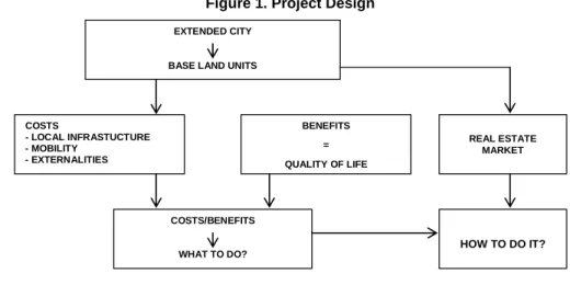
- Characterization of the real estate market in the process of urban dispersion. 2. Project Design
Figure 1. Project Design
EXTENDED CITY
BASE LAND UNITS
COSTS - LOCAL INFRASTUCTURE - MOBILITY - EXTERNALITIES BENEFITS = QUALITY OF LIFE REAL ESTATE MARKET COSTS/BENEFITS WHAT TO DO? HOW TO DO IT? 2.1 Urban Territories
2.1.1. Dispersion is assumed to be one of many urban forms existing within the Extended City. The Project’s aim is to compare these different urban settlement forms (some compact, some dispersed) among themselves on a local scale, the scale of what has been named a Base Land Unit (BLU). Ultimately, the goal is to find directions for City Planning, namely for dispersed areas.
2.1.2. There are, then, some presumptions on the concepts put forward, namely:
- Extended City: each continuous city and its surroundings, composed by urban fragments or dispersed development, intertwined with more or less residual agricultural and forest areas;
172 - BLU: similar to the neighbourhood or neighbourhood unit concepts, to be applied to areas of dispersed
occupation;
- City Planning: defined as an effort to rationally locate and articulate infrastructure, buildings and their uses on a given territory; it is further assumed that such a quest for rationality should entail cost/benefit analysis aiming at maximizing the quality of life/ environmental and financial costs binomial.
2.1.3. Further and more precise definition and examples of these and other concepts should be sought, namely: continuous, fragmented and dispersed settlements on the BLU-scale; dispersed settlements’ morpho-typologies on the BLU-scale.
2.2 Local infrastructure costs
2.2.1. By Public Infrastructure it is meant the several networks and systems, all public spaces and facilities of a local scope, namely: water supply systems, domestic and pluvial sewer systems; collection of solid waste, electricity, street illumination and telecommunications networks, gas system; public streets, parking, public spaces; basic support equipment for BLUs.
2.2.2. To know its costs, one needs to:
- Identify and characterize different solutions/typologies for each infrastructure possible in the continuous city and/or in the different forms of dispersed settlements;
- Identify their respective initial construction costs per unit;
- Identify management and conservation costs (inexistent or difficult to reach information) 2.2.3. Finally, it is the Project’s purpose to:
- Identify and compare standard infrastructure costs in BLUs representing different settlement forms; - Create scenarios with different infrastructure service levels for dispersed BLUs, relating each one to
the maximum construction loads admissible. 2.3 Integrated Mobility Costs
2.3.1. The aim is to calculate integrated costs per km and per user for each transport mode used in Portugal, including vehicle and energy consumption costs and environmental externalities. Infrastructure costs are not considered, for they are already accounted for among local infrastructure.
2.3.2. The task will entail:
- Identifying the different transport modes operating in Portugal; - Quantifying and characterizing each transport mode’s vehicle fleet;
- Identifying hypothetical regional differences (based on the two case-study cities). 2.3.3. Through the case-studies and respective mobility surveys, it will be possible to: - Compare mobility costs in different BLUs, namely compact and dispersed ones; - Design of possible mobility organization scenarios for dispersed BLUs.
2.4 Quality of Life
2.4.1. “Quality of Life” is a threshold concept between several scientific subjects and research fields, taking specific terms or dimensions according to the different facets of life under scrutiny (Felce and Perry, 1995). Since the 1960s, it has evolved from an essentially economic perspective, based on income and individual utility, to current approaches emphasising its multidimensionality and the conjugation of subjective/qualitative perceptions and objective/quantitative conditions with the individual and community levels (Hancock, 2000). Departing from the concept’s multidimensionality, a specific focus is needed: that of different urban settlement forms’ impact on quality of life.
2.4.2. The broad QoL concept, when put against the Project’s purposes, is narrowed down to a evaluation of different urban forms’ contribution to QoL, that is to say, of people’s assessment of different forms.
173 An attempt at the construction of an algorithm regarding QoL will be made. The algorithm should be adjustable according to different assessments of the attributes considered and allow the identification of different social groups/ opinion patterns.
The algorithm’s formulation should:
- Consider econometric methods for the estimation of utility functions (Constant Elasticity of Substitution, Cobb-Douglas);
- Consider Contingent Valuation methods;
- Anticipate two sorts of difficulties – quantifying and objectifying opinions and identifying opinion groups from individual judgements.
2.4.3. Such difficulties have brought about the question if quality of life is even measurable (see Nussbaum and Sen’s “The Quality of Life”, 1993). Facing them, attempting to translate the concept into an algorithm requires:
- Ability to synthesise, critical spirit and transparency in conceiving and divulging it; - Relativizing the concept by identifying dimensions which reveal different opinion groups. 2.5 Cost/Benefit Analysis
2.5.1. Following systemic approaches in planning, heavily reliant on mathematical models, there was a period of demystifying these methods’ alleged scientificity and neutrality, namely when seeking to quantify subjective matters (such as quality of life) and to integrate variables of distinct natures (like confronting economic costs, environmental costs and quality of life indicators).
2.5.2. However, if Spatial Planning is to be assumed as an effort of rationally localizing and articulating different land uses, then decision makers and the general public should be provided, with due caution, a framework as objective and explicit as possible on the existing dispersion dynamics, the costs they entail and the benefits they may carry (for whom?).
2.5.3. The data, as objective as possible, on costs and benefits of urban dispersion, as opposed to continuous settlement patterns, will allow for recommendations and conclusions to be drawn:
- On the attitude to adopt facing dispersion’s continuing growth, be it the need to avoid it or the possibility of admitting it, if following certain guidelines;
- On desirable scenarios for existing urban dispersion’s evolution, in what concerns infrastructure and/or mobility and/or construction loads, aiming at maximizing the quality of life/integrated costs ratio. 2.6 Real Estate Market
2.6.1. The implementation of any given spatial planning model requires knowledge on the real estate market’s functioning. That is why an understanding of the market leading to dispersed settlements will be sought:
- Stakeholders involved, main typologies of real estate products, used land characteristics, and processes of land and building transformation;
- Correlations between said agents, products and land characteristics and transformation processes. 2.6.2. With an opinion on “what to do”, knowledge on real estate dynamics and processes will allow recommendations on desirable urbanization processes and on how Public Offices should deal accordingly with the stakeholders involved in urban dispersion. In other words, it will allow recommendations on “how to do it”.
2.7 Case Studies
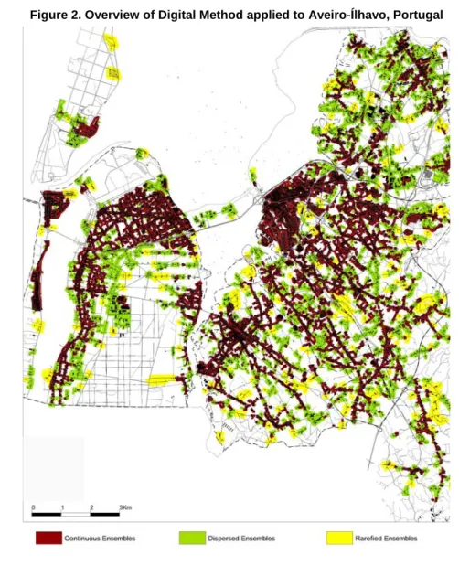
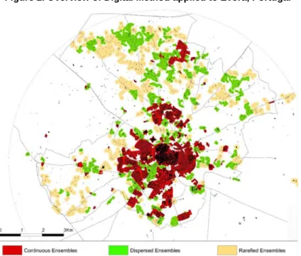
2.7.1. The case-studies are two mid-sized cities – Aveiro/Ílhavo and Évora – bearing different morpho-typological characteristics, including dispersed settlements. The outputs of a digital method based on
174 building continuities and roads they relate to allow the identification of continuous, dispersed and rarefied3 building ensembles, as seen on Figures 2 and 3. A brief look is enough to recognize different settlement patterns in each of the case studies.
2.7.2. In Aveiro-Ílhavo (Figure 2), Aveiro’s continuous and compact centre dilutes along its access ways. Buildings concentrate along them, creating a structure of built-up areas on their margins. Between them, small dispersed ensembles and agricultural and/or forest spaces abound, indicating a profound imbrication of construction and agricultural and forest areas. This linear settlement structure meets occasional concentrations in pre-existing agglomerations of reasonable significance. Finally, one should also mention compact ensembles by the seaside and vast unbuilt natural areas (delta; woods) which staunch otherwise pervasive constructive dynamics.
2.7.3. In Évora (Figure 3), the pattern is different, displaying a continuous and considerably compact central area with reasonably defined borders. Beyond it, a few continuous and compact ensembles emerge, disconnected from the rest of the continuous city. In the outer rings, dispersed and rarefied ensembles abound, with vast agricultural and forest spaces between them. The road network, despite having a natural influence on these ensembles’ location, does not play a determinant role in it.
Figure 2. Overview of Digital Method applied to Aveiro-Ílhavo, Portugal
3
The Method developed by the Team consists in aggregating buildings based on maximum pre-established distances between buildings (20m for continuous building ensembles, 90m for dispersed and 160m for rarefied ones). In some cases, marginal strips of roadways were integrated. A more detailed description of the Method will be presented elsewhere to this Congress (Jorge Carvalho and Carina Pais).
175 Figure 2. Overview of Digital Method applied to Évora, Portugal
2.7.2. According to the Project’s methodology, erudite knowledge will be gathered, systematized and confronted with both case-studies. This process is summarised in Figure 4.
Figure 4. Case Studies EXTENDED CITY
LBU Selection
Real Estate Market
- Quest. to residents (demand) - Quest. to promoters - Quest. to intermediaries Costs Infrastructure Costs Mobility Costs/ Benefits Questionnaire to Residents
- Real Estate demand - Mobility
- Quality of Life
2.7.3. Having identified and characterized each Extended City and subdivided them into BLUs, representative BLUs (continuous and dispersed ones) are selected as sample case-studies (actual; or acting as a referent for the construction of abstract type-cases), taking into account:
- Location within the extended city and uses set in;
- Morpho-typology (public space, lots and buildings; relationships among themselves); - Residents’ sociocultural characterization
2.7.4. The questionnaire (encompassing the following stages: conception, pilot questionnaire, questionnaire delivery and data handling) will provide data on:
- The concept of QoL, namely assessment parameters of each social group and/or place of residence, essential for building the algorithm;
- Demand for housing (effective demand and reasons behind last residential move, expectations and preferences) and, in dispersed BLUs, demand for facilities for economic activity;
176 2.7.5. Tasks relating to infrastructure costs include the following three subtasks:
- In-depth morpho-typological and functional characterization of each BLU;
- Calculating initial construction costs for each infrastructure, based on direct verification of its existence and applying unit costs;
- Design of service scenarios for each infrastructure in dispersed BLUs, relating them among themselves and with sensible construction loads.
2.7.6. For each BLU (actual or abstract) the purpose is, then, to obtain: integrated costs (local infrastructure and mobility); assessment parameters, differentiated by social groups/opinion patterns; confrontation of costs with benefits (assessment), referenced to several settlement patterns.
2.7.7. To gain knowledge on real estate markets in areas of dispersed occupation, real estate products on offer will be identified first, as well as their sites/land. Afterwards, promoters and intermediaries involved will be identified as well. These and municipal services will be interviewed and data on residents’ opinions and activities in place will be derived from the questionnaire. Crossing all the information gathered will provide insight into the processes that, departing from the available land, led to the construction of real estate products and also to the opinions/behaviour of supply and demand.
3. Fundamental operative questions
Work undertaken so far has allowed to identify three major fundamental questions within the Project’s Architecture, the answer to which has not been fully given yet:
- How to delimit/identify Urban Dispersion?
- How to survey people’s assessment of distinct Urban Forms (among which will be dispersed settlements)?
- How to calculate the integrated costs associated with each Urban Form? 3.1 How to delimit and identify Urban Dispersion?
3.1.1. Urban Dispersion questions the traditional Urban-Rural dichotomy, at least in what concerns the physical aspects of settlement patterns. Being an expression of today’s increasingly urban society, several authors consider it a new urban form, dependent on mobility (based mostly on the private car), constituent of the extended, diffuse city in which rurality subsists as a mere archetype.
Even if this is true on a cultural and experiential level (although it is felt that such a statement is worthy of a more thorough discussion), the question remains at the level of physical land use patterns. If, plainly put, traditional urban settlements are those based on buildings and public space/infrastructure and rural areas are essentially agricultural and/or forested, then dispersed settlements will be somewhere between these two extremes, areas where traditional urban and rural patterns mix, interpenetrate. If one’s purpose is to know and plan for this increasingly present Urban Dispersion, then one should begin by identifying and delimiting it with criteria as consensual as possible that simultaneously allow for comparable information, analysis and solutions to be gathered.
Between compact and continuous Urban areas and unbuilt Rural ones there is a wide array of in-between situations. Which threshold criteria separate Urban from Dispersed areas? And Dispersed from Rural ones? Following these questions, a final one arises: how to delimit a dispersed urban area?
3.1.2. The answer may depend on the scale of analysis. On a regional or national scale, the question may not even be posed, a geo-referenced grid may prove to be enough. But on a local scale, that of the
177 neighbourhood, the scale at which infrastructure service is organised, a fairly more precise delimitation is required. Reviewing existing studies, two observations are due when seeking a criterion:
- To be universal, it must be easily applicable, resorting to widespread IT instruments; - To be useful, operative, it must take into account at least existing buildings and ways These remarks have presided much of the Project’s initial reflections:
- Choosing the dispersed areas that will be samples for empirical work requires identifying and delimiting all dispersed areas which in turn implies that the concept itself is defined in the first place.
- A second question, following area delimitation, relates to characterizing and classifying them. In addition to defining what may be quantitative thresholds that separate Urban, Rural and Dispersed areas.
- If Urban Dispersion is an urban form, then it is important to find morpho-typologies that permit the distinction, when analysing and drafting of proposals, between the different realities “Urban Dispersion” encloses.
3.2 How to enquire people’s assessment of each Urban Form?
3.2.1. Another question that soon arose as one of the Project Team’s main concerns was how to get values for the benefits vector, particularly how to enquire urban forms.
These concerns mainly regard two intricately related levels:
- The first one is mostly conceptual and implies defining urban forms and the way they relate to the concept of QoL, translating into the definition of a set of attributes.
- The second one encompasses method issues related to the construction and application of the questionnaire to the case-study areas’ residents (in what concerns QoL). The relevance of such issues derives from the need to ensure that the elaborate theoretical framework behind the questionnaire gives way to simple questions, easily answered by residents from different social, economic and cultural backgrounds, whilst keeping the questionnaire as short and interesting as possible.
3.2.2. The intent of comparing costs and benefits of different urban settlement patterns requires that common territorial referents are adopted. Hence the abovementioned need to reach morpho-typological classifications of occupation forms, not only regarding traditional urban patterns, but also dispersed urban areas. The Project’s objective is, as said, to evaluate the contribution of different urban settlement forms to residents QoL. If people were asked to assess specific territories, the risk of factors not directly related to occupation forms, such as residents’ socioeconomic conditions or the area’s image, influencing people’s answers would be extremely high. Therefore, it was thought appropriate to resort to abstract territories in the questionnaire, to ensure that it were matters of form, uses and location and none other that are assessed.
3.2.3. It was therefore needed to define what would those abstract urban forms that would act as referents to calculating costs and benefits be. To do so, the concept of Urban Piece was devised (Carvalho et al., 2008), identifying a continuous territory with homogenous characteristics regarding urban fabric (cadastre, public space and buildings), an attribute often linked to the uses it houses and sometimes to the socioeconomic characteristics of its residents’. The process followed in defining those attributes of Urban Pieces which, thought of abstractly, influence individuals’ QoL followed two parallel paths (Belbute et al., 2008)
On the one side, departing from indicators of different Urban Pieces, attributes that differentiate them from each other and are influential in people’s choices were achieved. On the other, from the wide range of QoL indicators, those associable to Urban Pieces were chosen. In crossing both of them, QoL attributes on a
178 local scale that differentiate Pieces were found. These may be grouped under three great domains: urban fabric, use and location/context within the Extended City.
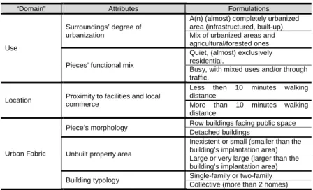
3.2.4. The step that followed consisted in confronting said list of attributes with the contingencies introduced by the Project’s design, namely the need to keep the number of attributes and their formulations to a minimum so that the Questionnaire to the residents’ feasibility is assured.
To do so, the Latin Square method was employed, for it allows obtaining information on a larger number of Urban Pieces than those that are actually surveyed.
For the same set of reasons, Urban Pieces are characterized through a set of six attributes with two formulations each (see Table 1), combined in twos. Applying the Latin Square narrows the amount of Pieces to enquire from the 64 possible combinations down to sixteen. However, by providing the assessment of each of the attributes’ formulations, it makes obtaining an individual assessment of each of the 64 Pieces possible. Thus, the combination of the attributes’ formulations is merely imposed by the method, not meaning that the attributes in question are naturally complementary.
3.2.5. Chosen attributes are presented in Table 1 and fit the three dimensions implied in Urban Pieces’ delimitation – urban fabric, use and location.
Table 1. Attributes of QoL on a local scale
“Domain” Attributes Formulations
Use
Surroundings’ degree of urbanization
A(n) (almost) completely urbanized area (infrastructured, built-up) Mix of urbanized areas and agricultural/forested ones
Pieces’ functional mix
Quiet, (almost) exclusively residential.
Busy, with mixed uses and/or through traffic.
Location Proximity to facilities and local
commerce
Less then 10 minutes walking distance
More than 10 minutes walking distance
Urban Fabric
Piece’s morphology Row buildings facing public space
Detached buildings
Unbuilt property area
Inexistent or small (smaller than the building’s implantation area) Large or very large (larger than the building’s implantation area)
Building typology Single-family or two-family
Collective (more than 2 homes)
3.2.6. In addition to the abovementioned narrowing down of concepts to the set of attributes in Table 1, “how to enquire?” is a relevant issue.
Two main aspects should be considered:
- Neutrality: an exclusively textual description of the Urban Pieces was set aside due to their abstract essence and the erudite nature of the concepts behind some of the attributes. Images accompanied by text were chosen instead, for more likely ensuring respondents’ comprehension of the complex conjugation of attributes at stake.
This graphic representation should be as neutral as possible, deprived of any connotation whatsoever, be it positive or negative. Furthermore, it should employ a restricted set of graphic elements (one sign only for every representation of a given attribute), combined in a simple fashion, allowing a rather intuitive reading of the image and a gradual appropriation of the lexicon employed, thus increasing answering speed.
179 - Size: the questionnaire on Urban Pieces is part of a broader questionnaire. The latter’s length and,
consequently, duration demand that ways of keeping the process lively and interesting are devised so that respondents are kept motivated to answer all questions as seriously as possible.
3.3 How to calculate integrated costs?
3.3.1. The third major question, transversal to the Project, relates to the attainment of integrated costs for subsequent confrontation with benefits. Firstly, the type of costs to consider was defined. Next, cost components to be accounted for were chosen.
3.3.2. Considering that the Project aims at comparing costs between urban settlements’ forms, average costs were adopted instead of marginal costs, more common in Cost-Benefit Analyses. The purpose is not to compare the costs of supplying an additional unit of infrastructure, but the average costs of building it according to the technical solution most suitable to the settlement pattern in question. It is not a matter of departing from an existing situation and calculating the cost of expanding its occupation, but one of, for a given Urban Piece, conceiving type-solutions and type-situations for which average costs will be found.
3.3.3. Considering the Project’s comparative purposes, resorting to user costs was not deemed appropriate because there are externalities that are not effectively paid by users and that should be accounted for. Consequently, costs are considered from a societal standpoint. The primary question in this Project is “how much does it costs?” and not “who pays for it?”, even though the latter is also extremely pertinent in a spatial planning process.
3.3.4. This societal logic has implications also for cost components to consider, demanding that every cost and externality are considered only once and financing costs are not taken into account. Specifically, and accordingly, the following were excluded:
- Fiscal load;
- Rates, tariffs and tolls; - Interest.
References
COST Action C10. Outskirts of European Cities. Brussels: European Commission - Directorate-General for Research,
2002.
Bauer, G. and J.-M.-. Roux. La Rurbanisation ou la Ville Éparpillée. Paris : Éditions du Seuil, 1976.
Belbute, J. M., J. L. Marques et al. Qualidade de Vida – uma análise à escala local. Actas do 14.º Congresso da Associação Portuguesa para o Desenvolvimento Regional, 2008, p 376-391. Internet:
http://www.apdr.pt/congresso/2008/pdf/B_tudo.pdf.
Burchell, R. W. The Costs of Sprawl 2000. T. R. 74. Washington, D.C.: Transportations Research Board, 2002. Burchell, R. W., N. A. Shad, et al. The Costs of Sprawl—Revisited. Washington, D.C., TCRP Report 39, 1998 Calthorpe, P. and W. Fulton. The Regional City: Planning for the End of Sprawl. Washington DC: Island Press, 2001. Carvalho, J., C. Pais et al. Custos de infra-estrutura local versus formas de ocupação do território urbano. Sociedade e Território, 2008, núm. 42, p. 110-117
Felce, D. and J. Perry. Quality of Life: Its Definition and Measurement. Research in Developmental Disabilities, 1995,
vol. 16, núm. 1, p. 51-74.
Font, A. L’Explosió de la Ciutat. Barcelona: COAC, 2004.
Gomes, C. S., J. L. Marques et al. A multidimensionalidade do conceito de Qualidade de Vida. Sociedade e Território,
2008, núm 42: 137-146
Hancock, T. (2000): Healthy Communities must also be Sustainable Communities. Public health reports, vol. 115, núm.
2-3, p. 151-156.
Indovina, F. La Cittá Diffusa. Venezia: Doest Ed, 1990.
l'APUMP and l'IET La Ville Étalée en Perspectives. Nîmes: Champ Social Éditions, 2002.
Mayoux, J. Demain, L’éspace. L´habitat Individuel Périurbain. Report de la mission d´étude. Paris: Ministére de
L'Environnement et du Cadre de Vie - service d'information, 1979.
Nussbaum, M. C. and A. Sen. The Quality of Life. Oxford: Oxford University Press, 1993.
Portas, N., Á. Domingues, et al. Políticas Urbanas – Tendências, estratégias e oportunidades. Lisboa: Fundação
Calouste Gulbenkian, 2003.