GRAVITY INVERSION OF THE ONSHORE POTIGUAR BASIN BASEMENT RELIEF:
SIMULATING RESULTS ASSOCIATED WITH DIFFERENT EXPLORATORY PHASES
Marina B. Gaino
1,3, Julio Cesar S.O. Lyrio
2and Walter E. Medeiros
3,4ABSTRACT.Gravity inversion results aiming to estimate the crystalline basement relief of the onshore Potiguar Basin are presented. It is assumed that the density contrast between the sediments and the crystalline basement is constant and known. The sediments are approximated with vertical rectangular prisms whose thick-nesses, representing the depths to crystalline basement, are the parameters to be estimated from the gravity inversion. In all cases, the inversion process was stabilized with smoothness constraint on the spatial variation of the basement relief. Besides the gravity data, we used information about the basement relief obtained from boreholes and from seismic interpretation. These data were combined in order to compose three different scenarios simulating different phases during the exploratory development of the basin. In the first scenario we used the gravity data only. In the second scenario we worked with two combinations, first we combined the gravity data with information from boreholes, and second, with the basement relief reference model that resulted from the seismic interpretation. Finally, in the third scenario, we used the gravity data, the information from the boreholes and the reference model obtained from the seismic interpretation. In all scenarios, we obtained reliable estimates for the basement relief. Concerning the discrepancies among the results, the estimates obtained with additional constraints (from boreholes and/or seis-mic interpretation) increased the overall resolution of the basement relief and the reliability of the absolute depth values. However, it is important to stress that the first scenario already yielded a reliable estimate to the basin relief. If one takes into account the huge difference both in financial cost and environmental impact associated with gravity and seismic surveys, respectively, as well as with borehole drilling, this result highlights the great importance of properly using the gravity data in the initial exploratory phase of the basin.
Keywords: gravity inversion, basement relief, Potiguar Basin, constrained inversion.
RESUMO.Este trabalho apresenta aplicac¸˜oes de invers˜ao gravim´etrica para a estimativa do relevo do embasamento cristalino da Bacia Potiguar emersa. Admite-se que o contraste de densidade entre os sedimentos e o embasamento da bacia ´e constante e conhecido. O pacote sedimentar ´e aproximado por um conjunto de prismas lateralmente justapostos cujas espessuras, ou profundidades at´e o embasamento, s˜ao os parˆametros a serem estimados na invers˜ao. Em todos os casos, o processo de invers˜ao foi estabilizado com o uso do v´ınculo de suavidade na variac¸˜ao espacial do relevo do embasamento. Al´em das medidas gravim´etricas, foram utilizados dados de poc¸os e/ou oriundos da interpretac¸˜ao s´ısmica, em diferentes combinac¸˜oes, de modo a simular diferentes etapas, ou cen´arios, de explorac¸˜ao da bacia ao longo do tempo. No primeiro cen´ario foram utilizados somente dados gravim´etricos. No segundo cen´ario, simulamos duas situac¸˜oes, em ambas adicionando outras informac¸˜oes aos dados gravim´etricos: na primeira delas, adicionamos somente v´ınculos de poc¸os e, na segunda, apenas um modelo s´ısmico de referencia para o embasamento. Por fim, no ´ultimo cen´ario foram agregados aos dados gravim´etricos os dados de poc¸os e o modelo s´ısmico. As estimativas obtidas para o relevo do embasamento revelaram nitidamente o arcabouc¸o da bacia em todos os cen´arios. Em relac¸˜ao `as variac¸˜oes das profundidades entre os cen´arios, as inclus˜oes dos v´ınculos dos poc¸os e do modelo s´ısmico aprimoraram a resoluc¸˜ao global dos resultados, como esperado. Contudo, ´e relevante destacar que a invers˜ao no primeiro cen´ario j´a forneceu um relevo bastante aproximado do arcabouc¸o conhecido da bacia. Se levarmos em conta as grandes diferenc¸as de custo financeiro e de impacto ambiental, respectivamente associados com os levantamentos gravim´etrico e s´ısmico, bem como com a perfurac¸˜ao de poc¸os, esse resultado evidencia a grande importˆancia de uma adequada utilizac¸˜ao dos dados gravim´etricos nas fases explorat´orias iniciais de uma bacia.
Palavras-chave: invers˜ao gravim´etrica, relevo do embasamento, Bacia Potiguar, invers˜ao vinculada.
1PETROBRAS/UO-RNCE/EXP/ABIG,Av. Euz´ebio Rocha, 1000, Cidade da Esperanc¸a, 59070-660Natal, RN, Brazil. Phone: +55(84) 3235-3855; Fax: +55(84) 3235-3237 – E-mail: [email protected]
2PETROBRAS/E&P/GEOF/MNS, Av. Rep´ublica do Chile, 330, Torre Leste, 11◦andar, Centro, 20031-170 Rio de Janeiro, RJ, Brazil. Phone: +55(21) 2144-1867 – E-mail: [email protected]
3Graduate Program in Geodynamics and Geophysics (PPGG/UFRN), Department of Geophysics, Universidade Federal do Rio Grande do Norte, Centro de Ciˆencias Exatas e da Terra (CCET/UFRN), Lagoa Nova, 59072-970 Natal, RN, Brazil. Phone: +55(84) 3342-2502 (ramal 205) – E-mail: walter@geof´ısica.ufrn.br
i i
“main” — 2014/4/10 — 20:52 — page 662 — #2
i i
662
GRAVITY INVERSION OF THE ONSHORE POTIGUAR BASIN BASEMENT RELIEF: SIMULATING RESULTS ASSOCIATED WITH DIFFERENT EXPLORATORY PHASESINTRODUCTION
The gravimetric inversion is a tool that can be used to estimate the relief of an interface between two homogeneous media such as, for example, the basement relief of a sedimentary basin. How-ever, this is a mathematically ill-posed problem due to the in-stability of the solutions. The usual way to rectify this problem is to minimize the functional, to adjust the gravity observations while incorporating constraints to the problem to stabilize its solution (e.g. Barbosa et al. (1999) and other references cited in this article).
This paper uses gravimetric inversion to estimate the base-ment relief of the onshore Rio Grande do Norte Basin. It is as-sumed that the density contrast between the sediments and the basement is constant and known, and an effective or average den-sity value was used (Litinsky, 1989). The sedimentary pack is approximated by a set of vertical prisms juxtaposed laterally whose thicknesses or depths up to the basement are the para-meters to be estimated in the inversion. The problem is stabilized with the smoothness constraints on the spatial variation of the basement relief and proximity to reference and/or known values, Barbosa et al. (1997, 1999) and Lyrio (2009).
In addition to the gravimetric measurements, borehole and/or seismic interpretation data were also used in different combina-tions, to simulate three different scenarios or stages of exploration in the basin over time. In the first scenario, the model used as input in the inversion is flat, in order to simulate complete lack of knowledge about the basin relief. In the second scenario, we have two options: the availability of borehole data or seismic refer-ence model. Finally, in the last scenario, the basement referrefer-ence seismic model is aggregated to the inversion process, coupled with information from the boreholes that reached the basement and those completed in the sedimentary section. The aim of this study is to investigate how the estimates of the basement relief change with the advancement of the exploratory phase, thus show-ing the benefits of applyshow-ing the gravimetric inversion method at different stages.
The paper is organized as follows. First, we will summarize the gravimetric inversion techniques used, and then present a synthesis of the structural framework of the onshore Potiguar Basin, as well as a description of all data used and the composed scenarios, and finally, we will discuss the results of the inversion for each scenario, followed by a comparative analysis.
GRAVIMETRIC INVERSION
The used gravimetric inversion technique is based on the study of Barbosa et al. (1997, 1999) on using smoothness constraints
on the spatial variation of the basement relief and the proxim-ity to known basement depth values from boreholes that reached the basement, for example. Operationally, we use the algorithm developed by Lyrio (2002, 2009), which extends the previous re-sults to also include constraints of unequal depths, associated with sites where the boreholes did not reach the basement. Math-ematically these constraints are introduced in the form of logarith-mic barriers (Lyrio 2002, 2009).
The sedimentary section is discretized into a set of juxta-posed and regular vertical prisms, whose thickness at each point is the depth to be estimated using the gravity field measured on the surface. It is assumed that the prisms have constant density (Litinsky, 1989), tops coincident with the Earth flat surface and regular spacing, equal to the mesh resulting from the interpola-tion of gravimetric data.
The algorithm used requires the knowledge of the residual gravity anomaly as a regular grid, the density contrast between the sediments and the basement, of a reference model for the basement relief, as well as control parameters associated with the stabilizing solution process. Information regarding boreholes, including those that did not reach the basement, may also be used. The regularization parameters used in the inversion algo-rithm were tested empirically in order to provide, simultaneously, good fit of the gravimetric data, solution stability and a reason-ably short computational time. Parameters were kept constant for all inversion scenarios.
STRUCTURAL FRAMEWORK OF THE ONSHORE POTIGUAR BASIN
The onshore Potiguar Basin is cretaceous and was implemented during the separation process of the South American and African plates (Matos, 1987). This basin is currently in a mature phase of its oil exploration that began in the mid-1970s. Therefore, from the point of view of exploration, it is assumed that the basin is well known, particularly its crystalline basement relief.
The structural framework of the onshore basin (Fig. 1) is de-fined by half-grabens and NE-SW internal highs, sandwiched be-tween shallow basement platforms, defining an asymmetric rift of rhombic shape (Matos, 1987). The Potiguar rift is chambered in half-grabens aligned in NE-SW direction and tilted to SE, Soares et al. (2003). These semi-grabens are bordered to the E-SE by the alignment of the Carnaubais faults (NE-SW), whose tailings are variable and may reach 5 km, constituting the faulted edge of the basin. Opposite, the flexural zone is associated with the Areia Branca Hinge, where the tailings are smaller and less significant.
Figure 1 – Structural framework of the onshore Potiguar Basin highlighting the main rift. Modified from Soares et al. (2003).
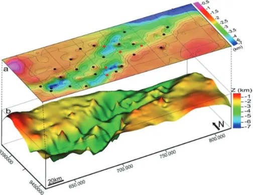
Figure 2 – Basement of the onshore Potiguar Basin obtained from the seismic depth map prepared by
Matos (1992): a) contour map, and b) Perspective view with vertical exaggeration 8×.
In turn, the NW-SE trending Apodi fault defines the S-SW bound-ary of the rift.
Although the NE-SW direction is prominent in the framework of the onshore Potiguar Basin, it is noteworthy the presence of another NW-SE alignment system, associated with the Afonso Bezerra fault system, which cuts orthogonally both the basin and the basement (Oliveira et al., 1993).
Geological details of the Potiguar Basin, including its stratig-raphy, can be found in Pessoa Neto et al. (2007).
USED DATA AND SCENARIOS
In this work, we use a reference model for the basement depths resulting from seismic interpretation, borehole information about
depth and gravity data. All data are associated with the onshore portion of the Potiguar Basin, except for the gravity data which included a slightly wider area (not shown), including the sea, to provide better definition of the regional and residual gravity fields. The onshore area comprises a rectangle of about 120× 230 km2 and encompasses the entire rift of the basin.
Figure 2 shows the reference model for the basement, which was built from the digitization of seismic structural map presented by Matos (1992) derived from the 2D seismic interpretation. Note that this model (Figs. 2a and 2b) reproduces very well all the structures shown in Figure 1. Also note that, for simplicity, we assume that the thickness of the sedimentary column is zero in the region outside the rift.
i i
“main” — 2014/4/10 — 20:52 — page 664 — #4
i i
664
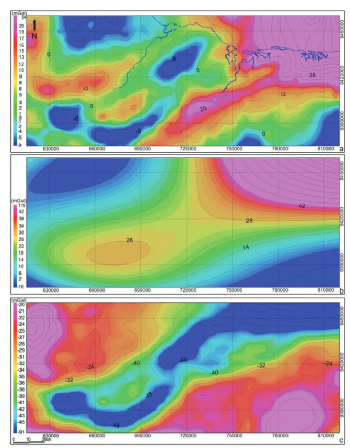
GRAVITY INVERSION OF THE ONSHORE POTIGUAR BASIN BASEMENT RELIEF: SIMULATING RESULTS ASSOCIATED WITH DIFFERENT EXPLORATORY PHASESFigure 3 – Maps of the onshore Potiguar Basin: a) Bouguer anomaly (contour interval of 4 mGal and coast blue line), b) regional gravity
anomaly obtained from the 4thorder polynomial fit (contour interval of 7 mGal), c) residual gravity anomaly (contour interval of 4 mGal).
Constraints on the depths of twenty-three boreholes that reached the basement, together with the information from five boreholes ending in the sedimentary section were added to the inversion process.
The gravity data used in this work originated from the data-base of the Universidade Federal do Rio Grande do Norte, Brazil, which aggregates different gravimetric stations and covers the entire Borborema Province and adjacent areas. These data were
previously treated by Oliveira (2008), who standardized all gravi-metric corrections.
The gravimetric measurements were interpolated onto a reg-ularly spaced grid with 5-km squares on each side, resulting in a set of 756 prisms for the gravimetric inversion process. Fig-ure 3a shows the resulting Bouguer field. Its separation into re-gional and residual components (including surrounding areas) was performed by the robust polynomial adjustment method of
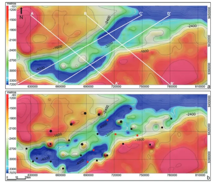
Figure 4 – Estimated basement relief of the onshore Potiguar Basin resulting from gravity inversions performed: a) Scenario 1 and
b) Scenario 2a. Also shown (a) location of profiles A-A’, B-B’, C-C’ and D-D’ in Figure 6, and (b) position of boreholes (black circles for the wells that reached the basement and red for wells ending in the sedimentary section) circles. Contour interval of 400 m.
Beltr˜ao et al. (1991). The 4thorder polynomial was chosen to rep-resent the regional component (Fig. 3b), resulting in the residual field shown in Figure 3c.
The effective density contrast (Litinsky, 1989) between sed-iments and basement was assumed constant and equal to −0.37 g/cm3. This value resulted from a series of inversion tests (with different density contrasts obtained from boreholes), in which the maximum depths of the basement were about 6 km, a reasonable limit to the maximum depth allowed for the basin.
The data described above were used in different combina-tions to simulate three different scenarios or basin exploration stages over time.
In the first scenario (Scenario 1), only the residual gravity field and an estimated density contrast are known, while a flat reference model is used as input to the inversion. Thus, a com-plete lack of knowledge about the basin relief is assumed, so that this first scenario would simulate an initial phase of its explo-ration process.
The second scenario analyzes two situations: the additional availability of borehole data (Scenario 2a), or a seismic reference model for the basement (Scenario 2b), thus reproducing interme-diate exploration stages of the basin. Finally, in the third scenario (Scenario 3), the seismic reference model is added to the inver-sion process, as well as information from boreholes, including those that have not reached the basement. This scenario, there-fore, simulates a very advanced exploration stage of the basin. The aim of this study is to investigate how the basement relief estimates change over time as the exploration advances, thus showing the benefits of applying the method of gravimetric in-version at different stages.
RESULTS AND DISCUSSION
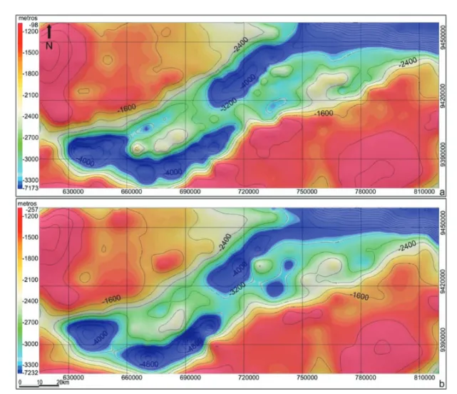
Estimates of the basement relief of the onshore Potiguar Basin associated with scenarios 1, 2a, 2b and 3 are presented as con-tour lines in Figures 4a, 4b, 5a and 5b, respectively. In order to
i i
“main” — 2014/4/10 — 20:52 — page 666 — #6
i i
666
GRAVITY INVERSION OF THE ONSHORE POTIGUAR BASIN BASEMENT RELIEF: SIMULATING RESULTS ASSOCIATED WITH DIFFERENT EXPLORATORY PHASESFigure 5 – Estimated basement relief of the onshore Potiguar Basin resulting from gravity inversions performed:
a) Scenario 2b, b) Scenario 3. Contour interval of 400 m.
facilitate viewing and comparing the results, the same estimates are also shown: (1) together as profiles strategically placed along the NW-SE (Figs. 6a and 6b) and NE-SW (Figs. 6c and 6d) trend-ing areas; (2) as maps and their views in perspective for each scenario (Figs. 7-10). Figure 7a also exhibits the used gravimet-ric measurements to provide the reader with an analysis of con-sistency and compatibility between the resolution obtained for the basement relief and the set of measurements. Figure 8a shows the boreholes aggregated into the inversion process, twenty-three wells (black circles) completed in the basement and five wells (red circles) completed in the sedimentary section.
The adjusted fields in all scenarios are not presented; how-ever, they all satisfactorily reproduce the residual gravity field (Fig. 3c).
In general, estimates of basement relief for all scenarios show the internal geometry of the onshore Potiguar Basin. It is notewor-thy that the resulting model in Scenario 2a shows some spurious features – in the form of pinnacles – associated with the borehole positions (Figures 4b, 8a and 8b). The most likely explanation for these is that they reflect too strong constraints to the depths
of the wells. However, the possibility that some of these wells are located on the edges of faults where abrupt depth changes occur, which are incompatible with the softness constraint im-posed, cannot be ruled out.
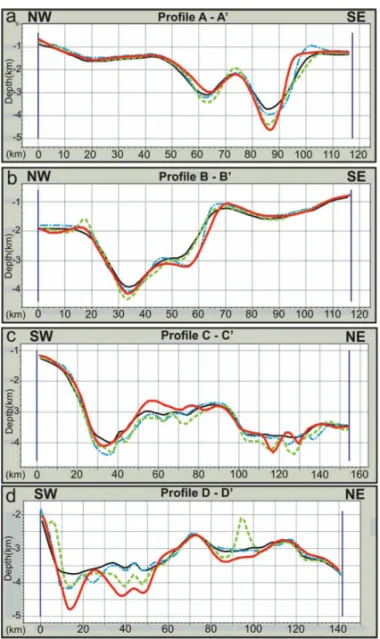
Regarding variations in basement depth, it is noted mainly through the profiles (Figs. 6a, 6b, 6c and 6d) that, as the con-straints are applied, the aggregate information increases the com-plexity level of the basement relief. Since these solutions are sta-ble, we can relate, at least as first approximation, the increasing complexity in the basement relief with increased resolution (ex-cept for the previously mentioned spurious features). The relief obtained in Scenario 3 (red lines in Figs. 6a-6d) is certainly the most reliable as it resulted from the reference model for the base-ment (derived from seismic interpretation), calibrated with bore-hole depths.
Subsequently, the comparative analysis of the results is going to be detailed. The first noteworthy observation from the results is that the gravimetric inversion in Scenario 1 has already provided a very good overview of the basement relief geometry (Figs. 4a, 7a and 7b). Note that this estimate was performed using only gravity
Figure 6 – Profiles of estimated basement relief resulting from gravity inversions
of the onshore Potiguar Basin: a) Profile A-A’ (NW-SE), b) Profile B-B’ (NW-SE), c) Profile C-C’(SW-NE), and d) Profile D-D’ (SW-NE). Legend: Scenario 1 (solid black line), Scenario 2a (dotted green line), Scenario 2b (dotted blue line), and Scenario 3 (solid red line). The location of the profiles is shown in Figure 4a. Note that the vertical and horizontal scales are different for each profile.
The inclusion of the depth data (derived from boreholes) in the gravimetric inversion of Scenario 2a gives, in general, a deeper estimation of basement relief (Figs. 4b, 8a and 8b), when compared to the inversion of Scenario 1 (Figs. 4a, 7a and 7b). However, as already noted, the resulting model has a few “pin-nacles” coincident with the borehole positions, especially those completed in the basement (Figs. 8a and 8b).
In Scenario 2b, the introduction of the seismic reference model for the basement (Figs. 2a and 2b) in the gravimetric in-version gives an estimation (Figures 5a, 9a and 9b) with
some-metric inversion in Scenario 3, provided not only a very good view of the basin framework (Figs. 5b, 10a and 10b), but also exhibited relief depths more consistent with the reference model, compared to previous results. This holds true not only in the deep regions of the basin but also in the shallower portions, which we believe, are virtually close to the actual features in the subsurface.
Noteworthy are the discrepancies in relation to the reference model (Figs. 2a and 2b) of the estimates obtained in Scenarios 2b and 3 (Figs. 9b and 10b), as illustrated in Figures 11a and 11c, respectively. The surfaces of the differences between the two estimates and the input model (Figs. 11b and 11d) allow us to conclude that the relief estimates are very similar to the seismic model, and generally deeper. However, in the central-southeast region of the Carnaubais fault (Fig. 1), aligned positive anomalies are observed, confirming that in this area the resulting estimates are relatively shallower than the seismic model (pink arrows in Figs. 11b and 11d).
These results suggest two hypotheses. The first, consider-ing the seismic model more accurate (that is, the best match to the actual basement relief), acknowledges that the discrepancies for the estimated gravity models could reflect possible variations of the density contrast between the sediments and the basement, or intra-basement variations of density. On the other hand, if the gravimetric model is more coherent (i.e., it is the best match to the true basement relief), then the seismic reference model contain inconsistencies that would distort the results. There are several possible explanations in this case, among them, inconsistencies in the time-depth conversion process associated with, for exam-ple, lateral velocity variations within the sedimentary pack.
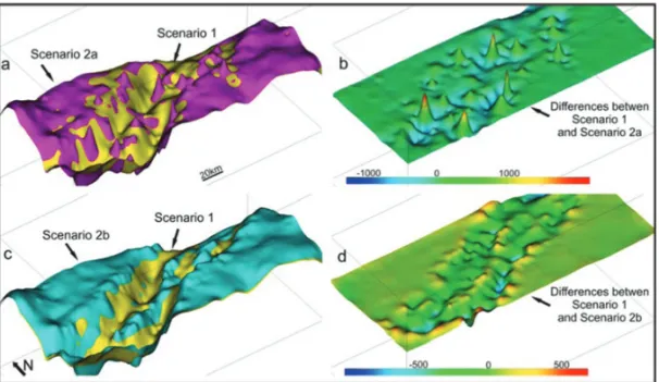
By jointly comparing the resulting estimates of inversion of Scenarios 1 and 2a (Fig. 12a), we note that, despite the simi-larity between the estimated reliefs, it is noteworthy the presence of spurious features associated with “pinnacles” in the boreholes (Fig. 12 b). The comparison between the estimated reliefs in Sce-narios 1 and 2b (Fig. 12c), the surface corresponding to the dif-ference between these estimates exhibits only minor anomalies possibly associated with the seismic reference model (Fig. 12d).
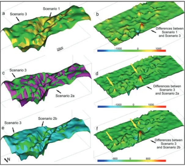
Moreover, the comparison between Scenarios 1 and 3 (Fig. 13a) shows similar responses differing mainly in the site of aggregate constraints (Fig. 13b). Regarding the comparison be-tween the estimates obtained in Scenarios 2a and 3 (Fig. 13c),
i i
“main” — 2014/4/10 — 20:52 — page 668 — #8
i i
668
GRAVITY INVERSION OF THE ONSHORE POTIGUAR BASIN BASEMENT RELIEF: SIMULATING RESULTS ASSOCIATED WITH DIFFERENT EXPLORATORY PHASESFigure 7 – Estimated basement relief of the onshore Potiguar Basin resulting from the gravimetric
inversion performed in Scenario 1: a) contour map with the location of gravimetric stations (black dots), b) Perspective view with vertical exaggeration 8×.
Figure 8 – Estimated basement relief of the onshore Potiguar Basin resulting from the gravimetric
inversion performed in Scenario 2a: a) Contour map showing locations of wells completed in the base-ment (black circles) and wells ending in the sedibase-mentary section (red circles), b) Perspective view with vertical exaggeration 8×.
the surface of the resulting difference (Fig. 13d) reproduces the positions of the wells, highlighting two anomalies (yellow arrows in Figure 13d), which we believe represent two unusually shallow wells ending at the edge of the rift fault.
Finally, the comparison between the reliefs obtained in Sce-narios 2b and 3 (Fig. 13e) shows a striking similarity, since the anomalies seen on the surface of the differences (Fig. 13f) display low amplitude and reproduce the information of relief
Figure 9 – Estimated basement relief of the onshore Potiguar Basin resulting from the gravimetric
inversion performed in Scenario 2b: a) contour map, b) Perspective view with vertical exaggeration 8×.
Figure 10 – Estimated basement relief of the onshore Potiguar Basin resulting from the gravimetric
inversion performed in Scenario 3: a) contour map, b) Perspective view with vertical exaggeration 8×.
variations aggregated by boreholes and the input model, but only locally (yellow arrows in Fig. 13f) at the same site already de-scribed in Figure 13d, but less evident (compare the scales of Figs. 13d and 13f).
Note then that, in general, in Scenario 3 the effect of “pinna-cles” in the boreholes is reduced by the inversion process with
the inclusion of a more accurate reference model. In this case, the borehole constraints helped to calibrate the depths, ensuring the effectiveness of the results with respect to the absolute values of the estimated depths. However, the gain in Scenario 1 compared to Scenario 3 was not as significant, since the regional features of the basin framework had already been defined in the gravity
i i
“main” — 2014/4/10 — 20:52 — page 670 — #10
i i
670
GRAVITY INVERSION OF THE ONSHORE POTIGUAR BASIN BASEMENT RELIEF: SIMULATING RESULTS ASSOCIATED WITH DIFFERENT EXPLORATORY PHASESFigure 11 – Perspective views to compare the estimates of the basement relief of the onshore Potiguar Basin and seismic
model: a) Overlap of the seismic model (red) and the estimate associated with Scenario 2b (blue), b) surface corresponding to the difference between these two models, c) overlap of the seismic model (red) and the estimate associated with Sce-nario 3 (green), d) Surface referring to the differences between these two models. Observe the pink arrows showing the central-southeast region of the Carnaubais fault. Vertical exaggeration 8× in all perspectives.
Figure 12 – Perspective views to compare the estimates of the basement relief of the onshore Potiguar Basin: a) overlap of
the estimates associated with Scenario 1 (yellow) and the second (pink), b) surface corresponding to the difference between these two models, c) overlap of the estimates associated with Scenarios 1 (yellow) and 2b (blue), d) surface corresponding to the differences between these two models. Vertical exaggeration 8× in all perspectives.
inversion associated with the first scenario. If we consider the low cost and low environmental impact characteristic of a gravity survey, we see that in terms of cost/benefit, the results obtained in Scenario 1 are significant and validate an extensive analysis of the gravity data in the initial exploratory phases.
CONCLUSIONS
In this work, gravimetric measurements and information from boreholes from seismic interpretation were combined
simulat-ing three different scenarios or exploratory stages of the onshore Potiguar Basin over time. In the first scenario, only gravity data were used. In the second scenario, gravity data were combined first, with borehole constraints and second, with a seismic refer-ence model for the basement. Finally, in the last scenario, gravi-metric and borehole data and the seismic reference model for the basement were all combined.
The estimates obtained for the basement relief clearly re-vealed the basin framework in all scenarios. The main conclusion
Figure 13 – Perspective views to compare the basement relief estimates of the onshore Potiguar Basin: a) overlap of the
estimates associated with Scenario 1 (yellow) and 3 (green), b) surface corresponding to the difference between these two models, c) overlap of the estimates associated with Scenarios 2a (pink) and 3 (green), d) surface corresponding to the differ-ences between these two respective models, e) overlap of the estimates associated with Scenarios 2b (blue) and 3 (green), f) surface corresponding to the differences between these two models. Observe the arrows (yellow) probably referring to the boreholes located on the edge of faults. Vertical exaggeration 8× in all perspectives.
is that the most striking features of the structural framework of the basin have been well delineated in the inversion associated with Scenario 1. This is important, especially when taking into account the costs and the environmental impact of a gravity sur-vey in relation to seismic sursur-vey or well drilling. The estimates obtained at later stages helped to enhance depth absolute values by increasing the resolution of the estimated relief, as additional information was added to the process.
Certainly, the basement relief of Scenario 3 estimated using borehole data and the seismic reference model is the most reliable because it is closer to the acceptable values for the area, not only in the rift region but also in the shallower portions of the basin.
It is noteworthy that, even when a basement relief obtained by the seismic interpretation is available; it is valid to estimate the relief based on the gravimetric inversion, because the dis-crepancies between the two methods can reveal inconsisten-cies in the assumptions used in the processing, such as
intra-basement density variations, seismic quality problems or incon-sistencies in the time-depth conversion process. Moreover, using gravity inversion coupled with borehole constraints and seismic model can ensure higher accuracy in the evaluation of a particu-lar area, especially in cases where small discrepancies are found between the estimates derived from seismic and gravimetric in-terpretations. In this case, lack of inconsistency validates the hy-pothesis used independently to treat individually the data from each method.
ACKNOWLEDGEMENTS
The authors thank the Universidade Federal do Rio Grande do Norte for providing the gravity data and PETROBRAS for provid-ing the InvGrav package used for the gravity inversion. Walter E. Medeiros thanks CNPq for the scholarship PQ (Process No. 304.301/2011-6) and associated grant.
i i
“main” — 2014/4/10 — 20:52 — page 672 — #12
i i
672
GRAVITY INVERSION OF THE ONSHORE POTIGUAR BASIN BASEMENT RELIEF: SIMULATING RESULTS ASSOCIATED WITH DIFFERENT EXPLORATORY PHASESREFERENCES
BARBOSA VCF, SILVA JBC & MEDEIROS WE. 1997. Gravity inversion of basement relief using approximate equality constraints on depth. Geo-physics, 62(6): 1745–1757.
BARBOSA VCF, SILVA JBC & MEDEIROS WE. 1999. Gravity inversion of a discontinuous relief stabilized by weighted smoothness constraints on depth. Geophysics, 64(5): 1429–1437.
BELTR˜AO JF, SILVA JBC & COSTA JC. 1991. Robust polynomial fitting method for regional gravity estimation. Geophysics, 56(1): 80–89. LITINSKY VA. 1989. Concept of effective density. Key to gravity determi-nations for sedimentary basins. Geophysics, 54: 1474–1482. LYRIO JCSO. 2002. Invers˜ao n˜ao-linear de dados gravim´etricos na Bacia do Recˆoncavo. In: VIII Simp´osio de Geof´ısica da Petrobr´as (008:2002, Vit´oria). Proccedings... Rio de Janeiro, Petrobr´as. CD-ROM.
LYRIO JCSO. 2009. Processing and inversion of full tensor gravity gra-diometry data. Faculty and the Board of Trustees of the Colorado School of Mines (USA) CSM Department of Geophysics, Number T6617, PhD Thesis. 244 pp.
MATOS RMD. 1987. Sistema de rifts Cret´aceos do NE Brasileiro.
In: Semin´ario de Tectˆonica da PETROBRAS – PETROBRAS/CENPES/ DEPEX. Rio de Janeiro, Atas, 126–159.
MATOS RMD. 1992. Deep Seismic profiling, basin geometry and tec-tonic evolution of intracontinental rift basins in Brazil. Cornell University, Ithaca, New York (USA). Ph.D. Thesis 276 pp.
OLIVEIRA DC, MATOS RMD & SOARES UM. 1993. Contribuic¸˜ao ao estudo das estruturas rasas na Bacia Potiguar: analise estrutural do afloramento de Afonso Bezerra (RN) e adjacˆencias. In: SBG/N´ucleo Bahia-Sergipe, Simp. Nac. de Estudos Tectˆonicos, 4, Belo Horizonte, 306–311.
OLIVEIRA RG. 2008. Arcabouc¸o geof´ısico, isostasia e causas do mag-matismo cenoz´oico da Prov´ıncia Borborema e de sua margem continen-tal (Nordeste do Brasil). Nacontinen-tal: Universidade Federal do Rio Grande do Norte. Ph.D. Thesis, 441 pp.
PESSOA NETO OC, SOARES UM, SILVA JGF, ROESNER EH, FLOREN-CIO CP & SOUZA CAV. 2007. Bacia Potiguar – Cartas Estratigr´aficas. Boletim de Geociˆencias da PETROBR´AS, 15(2): 357–369.
SOARES UM, ROSSETTI EL & CASSAB CT. 2003. Bacia Sedimentares Brasileiras: Bacia Potiguar. Phoenix, Aracaj´u, 5(56): 1–7.
Recebido em 16 maio, 2012 / Aceito em 12 novembro, 2012 Received on May 16, 2012 / Accepted on November 12, 2012
NOTES ABOUT THE AUTHORS
Marina Beatriz Gaino. Geologist (Universidade Estadual Paulista – UNESP, Rio Claro – 1988) and Master in Geophysics (Universidade Federal do Rio Grande do
Norte – UFRN – 2012). Works with Geophysics at Petrobras since 1989, interpreting seismic/geological data in exploration of hydrocarbons. Main interests: seismic interpretation and potential methods, focusing on gravimetry.
Julio Cesar Soares de Oliveira Lyrio. Geologist (Universidade Federal do Rio de Janeiro – UFRJ – 1985) and Ph.D. in Geophysics from Colorado School of Mines
(CSM) – USA, in 2009. Works as a geophysicist at Petrobras since 1987, analyzing and interpreting potential methods data. Main interests are gravity gradiometry, gravity inversion and researching new methodologies applied to the potential methods field.
Walter Eug ˆenio de Medeiros. Civil Engineer (Universidade Federal do Rio Grande do Norte – UFRN – 1981), Master (UFBa – 1987) and Ph.D. in Geophysics
(Universidade Federal do Par´a – UFPA – 1993). Currently, works as a Professor in the Department of Geophysics UFRN and is the coordinator of undergraduate Geophysics, in conjunction with the graduate program in Geophysics and Geodynamics UFRN, as advisor in 10 masters and 6 doctoral degrees. Areas of inter-est are: applied geophysics (inverse problems, tectonophysics, assessment of exploration potential of sedimentary basins, prospecting for groundwater and shallow geophysics). He has published 32 articles in national and international journals and 1 textbook. Holds 1A researcher position from CNPq and is a member of the editorial board of the Journal of Applied Geophysics and the Brazilian Journal of Geophysics.