SPATIAL DATA INFRASTRUCTURES MODEL FOR
DEVELOPING COUNTRIES
Chinonye Cletus Onah
SPATIAL DATA INFRASTRUCTURES MODEL FOR
DEVELOPING COUNTRIES
A case study of Nigeria
Dissertation supervised by
Professor Marco Painho, Ph.D
Dissertation co-supervised by
Professor Pedro Cabral, Ph.D
Professor Michael Gould, Ph.D
ACKNOWLEDGEMENTS
I would like to first of all thank the European Commission for this singular
opportunity given to me to participate in this prestigious ERASMUS MUNDUS
Fellowship Scheme. To them I owe much gratitude and pledge that the knowledge so
acquired will be used in accordance with the fundamental ideals of the ERASMUS
MUNDUS PROGRAMME.
Secondly, my Professors in the Universitat Jaume I, Spain, through Institute for
Geoinformatics, University of Muenster, Germany, to the Instituto Superior de
Estatística e Gestão de Informação , Universidade Nova de Lisboa, Portugal. Most
outstanding among them are the very supervisors of this work, Professor Doutor
Marco Painho, Professor Doutor Pedro Cabral and Professor Doctor Michael Gould.
To them I say a thousand thanks.
I equally wish to express my gratitude to my family, immediate and extended for
their prayers, support and patience during the 18months sojourn in Western Europe.
SPATIAL DATA INFRSTRUCTURES MODEL FOR
DEVELOPING COUNTRIES
A case study of Nigeria
ABSTRACT
This research explores the basics of SDI, and investigates the National SDI of
different countries. Further, the research analyses SDI implementation in developing
country with specific reference to the National Geospatial Data Infrastructure
(NGDI) of Nigeria. The research assesses the status and the milestones of NGDI
implementation using key SDI components as assessment variables. These
components were grouped into four classes: Policy and Legal Issues, Technical,
Funding and People. A questionnaire survey via email was conducted on the
stakeholders and users of geoinformation in Nigeria. From the analysis, the NGDI
has an advantage of having a national policy backing its implementation and the
establishment of the coordinating body. However, the lack of SDI directive and
funding are major hurdles in the implementation of the NGDI making it lack behind
most of the selected case study countries in other key components. Nigeria is also
found to be applying a Mixed Model of NSDI implementation as both product model
and process model are evident in the NGDI. In the real sense of access network and
KEYWORDS
Clearinghouse
Metadata
National Geospatial Data Infrastructure (NGDI)
Spatial Data Infrastructures (SDI)
ACRONYMS
ASDI - Australian Spatial Data Infrastructures
ANZLIC - Australian and New Zealand Land Information Council
EUROGI - European Umbrella Organization for Geographic Information in Europe
GIS - Geographical Information Systems
ICDE - Infrastructura Colombiana de Datos Espaciales
NASRDA - National Space Research and Development Agency
NGDI - National Geospatial Data Infrastructures
NGII - National Geographic Information Infrastructure
NSIF- National Spatial Information Framework
NSDI - National Spatial Data Infrastructures
TABLE OF CONTENTS
ACKNOWLEDGEMENTS……….. iii
ABSTRACT………...iv
KEYWORDS ………...v
ACRONYMS ………...vi
INDEX OF TABLES………... vii
INDEX OF FIGURES………ix
1. INTRODUCTION………... 1
1.1 Background……… 1
1.2 Statement of Problem……… 1
1.3 Research Objectives……….. 2
1.4 Research Questions……… ………3
1.5 Research Hypotheses………... 3
1.6 Research Methodology……….. 4
1.7 Organization of the Thesis………. 4
2. SPATIAL DATA INFRASTRUCTRUCTURES AND NATIONAL SDI CASE STUDIES ……… 6
2.1 Introduction……… 6
2.2 Definitions of SDI………. 6
2.3 Components of SDI………7
2.3.1 Data……… 8
2.3.2 Metadata……… 8
2.3.3 Standards……….. 8
2.3.4 Access Network……… 9
2.3.5 People and Partnership………. 9
2.3.6 Policies and Institutional Arrangement………. 10
2.5 Levels of SDI ………11
2.6 SDI Development Models………. 12
2.7 National SDI Initiative………. 13
2.7.1 Australian Spatial Data Infrastructure……….. 14
2.7.2 National Spatial Data Infrastructure (USA)……….. 16
2.7.3 National Geographic Information Infrastructure (The Netherlands)………. 20
2.7.4 National Spatial Information Framework (South Africa) ………23
2.7.5 Infraestructura Colombiana de Datos Espaciales (Colombia)... 25
2.7.6 NSDI in Indonesia……… 27
2.8 Summary and Conclusions……….. 29
3. THE NGDI AND RESEARCH METHODOLOGY……… 32
3.1 Introduction……….. 32
3.2 Nigeria at a Glance……… 33
3.3 NGDI and National Geoinformation Policy……….. 34
3.3.1 Driving Forces……….. 34
3.3.2 The NGDI Organization……….. 34
3.3.3 NGDI Components……… 36
3.4 Research Methodology……….. 40
3.4.1 Introduction……….. 40
3.4.2 A Review of SDI Assessment ………. 40
3.4.3 Adopted Methodology……….. 41
3.4.4 Questionnaire Survey ………... 41
3.5 Conclusion………..………42
4. RESULTS ……….. 44
4.1 Introduction………. 44
4.2 Analysis by Respondents………. 46
4.2.1 Analysis by Sector………. 46
4.2.3 Analysis by Position Rank………. 47
4.2.4 Analysis by Scores……… 48
4.3 Analysis by Indicators……….. 49
4.3.1 Policy and Legal Issues……… 51
4.3.2 Technical……….. 52
4.3.3 Funding……… 53
4.3.4 People ……….. 54
4.4 Conclusion……… 54
5. CONCLUSIONS AND RECOMMENDATIONS……… 55
5.1 Introduction……….. 55
5.2 Conclusions……… 55
5.3 Hypotheses Testing……… 58
5.4 Limitations of the Study……….59
5.5 Recommendations for Future Work……… 60
BIBLIOGRAPHIC REFERENCES……… 61
APPENDICES………. 71
1 Descriptive Summary of Case Study Countries……… 72
1.1 Descriptive Summary of Australian SDI……….. 72
1.2 Descriptive Summary of United States NSDI……….. 73
1.3 Descriptive Summary of Netherlands NGII………. 74
1.4 Descriptive Summary of South African NSIF………... 75
1.5 Descriptive Summary of Colombian ICDE………... …….. 76
1.6 Descriptive Summary of Indonesian SDI……… 77
1.7 Descriptive Summary of Nigerian NGDI……….... 78
2 Comparison among case study countries……….. 79
2.2 Comparison of Access Network Component among
case study countries……….. ………80
2.3 Comparison of Standards Component among case study
Countries……….. 81
2.4 Comparison of Policy Component among case study
Countries……… …….. 82
2.5 Comparison of Institutional Arrangement Component
among case study countries………3
INDEX OF TABLES
Table 1: An abridged comparative analysis of case study countries 31
Table 2: Composition of NGDI Committee (Agbaje & Akinyede, 2005) 35
Table 3: Results of Questionnaire Survey converted to scores 45
INDEX OF FIGURES
Figure 1: Organization of the Research………. 5
Figure 2: High-Level SDI architecture, taken from the FGDC-NASA Geospatial Interoperability Reference Model (FGDC, 2003) ………….. 9
Figure 3: Nature and Relations between SDI Components (Rajabifard, 2003) ……….. 10
Figure 4: SDI Hierarchy, Relationships among different levels of SDI and levels of planning (After Rajabifard et al, 2000) …………... ……. 12
Figure 5: Product and Process based Models for SDI development (Rajabifard and Williamson, 2003)……….………13
Figure 6: Map showing case study countries ………14
Figure 7: NSDI Components Nebert, 2006) ………. ……. 19
Figure 8: Location map of Nigeria………. 33
Figure 9: NGDI Organizational Framework (National GI Policy, 2003) ……….. 36
Figure 10: A Proposed Model of NGDI Network with a common Clearinghouse (Agbaje, et al, 2008)……… 38
Figure 11: Analysis by Sector ……….. 46
Figure 12: Analysis by Location……… 47
Figure 13: Analysis by Position Rank………47
Figure 14: Analysis by Scores……….. 48
Figure 15: Policy and Legal Issues Indicator Class………51
Figure 16: Technical Indicator Class………. 52
Figure 17: Funding Indicator Class………53
1. Introduction
1.1 Background
The term Spatial Data Infrastructures (SDI) is often used to denote the relevant base
collection of technologies, policies and institutional arrangements that facilitate the
availability of and access to spatial data. The SDI provides a basis for spatial data
discovery, evaluation, and application for users and providers within all levels of
government, the commercial sector, the non-profit sector, academia and by citizens
in general, (SDI Cookbook, 2001). SDI is now playing a much broader role in a
modern society. The concept involves a complex digital environment including a
wide range of spatial databases and is concerned with standards, institutional
structures and technologies including the World Wide Web (WWW). SDI is now
moving to underpin an information society and enable a society to be spatially
enabled, (Rabajifard, 2006a).
Many countries worldwide are engaged in SDI development, which involves the
development of geospatial services that support public service delivery. This
development ranges from local to state/provincial, national and regional levels, to a
global level. However, this research will focus on the development of National SDI
(NSDI) as it applies to developing nations using National Geospatial Data
Infrastructures of Nigeria as a case study.
1.2 Statement of Problem
The SDI concept continues to evolve as it becomes a core infrastructure supporting
economic development, environmental management and social stability in developed
and developing countries. Due to its dynamic and complex nature, it is still a fuzzy
concept to many, with practitioners, researchers and governments adopting different
perspectives depending on their needs and circumstances, (Williamson, et al, 2003a).
Building SDI is a complex task, not just because of the evolving nature of the SDI
context to which such development must respond. (Williamson et al, 2003b). The
reality is that every country is at a different point in ‘SDI development continuum’,
with the developed world at the front end of the pole, and the developing countries
lagging far behind. In addition, many developing countries still have fragmented
institutional arrangements in the spatial data and land information area. It is not
uncommon to find a range of different government departments, often in different
ministries, responsible for different aspects of the management of the spatial data. It
is not surprising that moves to establish SDI under these circumstances are
problematic at best or non-existent at worst, (Williamson et al, 2003b).
Current understanding of SDI has seen the development of SDI models that have not
met user needs as expected, currently providing mainly an ability to access and
retrieve spatial data. Hence the concept of an SDI needs to progress so that it allows
more than just the ability to access spatial information. It needs to become an entity
that is enhanced so that it is possible to share data, business goals, strategies,
processes, operations and value-added products and services in order to support a
spatially enabled government (Rajabifard et al. 2005b). Some studies have been
carried out on the initiatives and models of SDI in different parts of the world such as
documented in Nebert, (2006) for USA, Rajabifard et al (2006b) for Australia, GSDI
Cookbook, Version 2, (2004) Columbia, Crompvoets et al 2004 Worldwide
development of national SDI clearing house.
However, a systematic study of the development of national SDI in developing
countries with a view to assessing the success, challenges and problem which in turn
will help in developing a model for SDI development is lacking.
1.3 Research Objectives
The steps to develop an SDI model vary among countries, depending on a country’s
background and needs. However, it is important that countries develop and follow a
roadmap for SDI implementation.
Such aspects include the development of an SDI vision, the required improvements
in capacity of the country, the integration of different spatial datasets, the
Geospatial Data Infrastructure Project in Nigeria under the National Space Research
and Development Agency (NASRDA) has as its main objectives, the discovery,
harmonization and standardization of geospatial data production and management,
and the provision of a platform for data sharing thereby eliminating data duplication
and conserving cost and time spent in producing already available data, (Agbaje and
Akinyede, 2005).
The major objective of this thesis is to assess the status and milestones of the
implementation of the Nigerian Geospatial Data Infrastructures and compare it with
selected NSDI. In order to achieve this objective, the following specific objectives
have to be achieved:
1. To examine the institutional arrangements in place to facilitate GI sharing;
2. To examine the issue of data access, data security, and partnerships among
producers and users;
3. To examine progress made so far in the implementation of NGDI;
4. To examine the NGDI implementation in the light of some selected NSDI
from other parts of the world.
1.4 Research Questions
The research will be guided by the following questions:
1. Who are the major stakeholders in NGDI?
2. What institutional arrangement is in place for the development of NGDI?
3. What are the problems and challenges facing the development of NGDI?
4. What lessons can be learnt from NGDI experience?
5. Is NGDI development in line with the selected NSDI trends?
1.5 Research Hypotheses
The research will test the following hypotheses.
H1: The current NGDI is effective and developing according to the
H2: The NGDI experience is not different from the NSDI of the selected
countries.
1.6 Research Methodology
A questionnaire survey was carried out to assess systematically the development and
status of National Geospatial Data Infrastructure of Nigeria with reference to the SDI
components. The survey coverered most aspect of NGDI components including
policy, organizational and legal issues, data access mechanism, technical standards
(metadata and clearinghouse) prices for data, people (including partnership).
Considering the complex, dynamic and constantly evolving nature of NGDI, a
multi-view assessment framework is used, (Grus, Crompvoets and Bregt, 2007; Makanga
and Smit, 2008). These NGDI components are grouped into four headings: Policy
and Legal Issues, Technical, Funding and People. The data collected from the
questionnaire was analyzed. Further, a comparative analysis of selected NSDI across
the world was made vis-à-vis NGDI. Finally, recommendations will be made on the
future of NGDI. The workflow of the methodology is shown in Figure 1.
1.7 Organization of the Thesis
The thesis is organized in the following chapters:
Chapter One covers general introduction, statement of problem, objectives of the
study, research questions, research methodology, hypothesis, and structure of the
thesis.
Chapter Two reviews the relevant literature. A general introduction of SDI is
presented, definitions, components, hierarchy and history. National SDI initiatives
are explored; Australia, USA, Colombia, The Netherlands, South Africa, and
Indonesia.
Chapter Three focuses on the National Spatial Data Infrastructure of Nigeria.
Further, chapter describes the methodologies that were used for data collection in the
Chapter Four presents the data. Data Analysis is carried out with respect to data
collected from the field.
Chapter Five: summarizes the thesis with conclusions, limitations of the study and
recommendations for future work.
Figure 1: Organization of the research
Problem Identification Research Objectives & Questions.
SDI and Review of NSDI
Data Acquisition
Questionnaire Documents Interview
Conclusions & Recommendations Data Analysis
2.
Spatial Data Infrastructures and National
SDI Case Studies
2.1 Introduction
This chapter explores the background of SDI, definitions, components, history and
trends. Different levels of SDI: corporate, local, state, national, regional are
identified. The chapter goes further to investigate a number of National SDI from
both developed and developing world. Australia, Netherlands and United States were
selected from the developed world, while Colombia, Indonesia and South Africa are
selected from the developing countries. A summary of their respective NSDI is given
at the end of the chapter. The NGDI of Nigeria, which is the primary case study area,
is however treated in Chapter 3.
2.2 Definition of SDI
SDI is playing a much broader role in today’s information society as it evolves from
just a concept to become a core infrastructure supporting economic development and
environmental management across nations. A few definitions of SDI will highlight
the nature of the infrastructure. The term “Spatial Data Infrastructure” (SDI) is often
used to denote the relevant base collection of technologies, policies and institutional
arrangements that facilitate the availability of and access to spatial data. The SDI
provides a basis for spatial data discovery, evaluation, and application for users and
providers within all levels of government, the commercial sector, the non-profit
sector, academia and by citizens in general, (SDI Cookbook, 2001).
The Federal Geographic Data Committee (1997) defines the United States’ national
SDI as an umbrella of policies, standards, and procedures under which organizations
and technologies interact to foster more efficient use, management, and production of
that generate or use geospatial data and the technologies that facilitate use and
transfer of geospatial data, (Nebert, 2006).
Coleman and McLaughlin (1998) defines the Global SDI as encompassing ‘the
policies, technologies, standards and human resources necessary for the effective
collection, management, access, delivery and utilization of geospatial data in a global
community’. Dutch Council for Real Estate Information (RAVI) defines the Dutch
National Geographic Information Infrastructure as a collection of policy, datasets,
standards, technology (hardware, software and electronic communications) and
knowledge providing a user with the geographic information needed to carry out a
task (Masser, 1998).
In summary, SDI is about the facilitation and coordination of the exchange and
sharing of spatial data between stakeholders in the spatial data community. The
principal objective of developing an SDI is to provide a proper environment in which
all stakeholders, both users and producers of spatial information can cooperate with
each other in a cost-efficient and cost-effective way to better achieve their targets at
different political/administrative levels.
2.3 Components of SDI
The definitions of SDI in 2.1 reveal some core components of SDI. The Australia
New Zealand Land Information Council (ANZLIC, 1998) identifies institutional
framework, technical standards, fundamental datasets, and clearing house networks
as the core components. The institutional framework defines the policy and
administrative arrangements for building, maintaining, accessing and applying the
standards and datasets. The technical standards define the technical characteristics of
the fundamental datasets. The fundamental datasets are produced within the
institutional framework and fully comply with the technical standards. The
clearinghouse network is the means by which the fundamental datasets are made
accessible to the community, in accordance with policy determined within the
In addition to these basic components, there is the people component which includes
the spatial data users, suppliers and any value-adding agents in between, who interact
to drive the development of SDI, (Williamson et al, 2003b).
2.3.1 Data
Data sets, which may be used for many different purposes and in many different
applications, are often referred to as base data, core data, fundamental data or
reference data. These datasets are widely needed for a variety of purposes and by
many agencies. The other types of datasets are known as thematic datasets which are
derived from the fundamental datasets, (SDI Africa, 2004).
2.3.2 Metadata
Metadata is a summary document about the dataset, including the geographic area
that the dataset covers, the custodian, who to contact to obtain a copy of the dataset
and other useful information that helps people decide whether or not the dataset is
useful for their particular purpose. A geospatial metadata record includes core library
catalog elements such as Title, Abstract, and Publication Data; geographic elements
such as Geographic Extent and Projection Information; and database elements such
as Attribute Label Definitions and Attribute Domain Values.
2.3.3 Standards
Effective use and sharing of spatial information requires that it adheres to known and
accepted standards. Standards facilitate the use of a wider range of data.
Development of formal standards is a consultative process through national standard
bodies through international standard organizations. Spatial data are standardized in
terms of geographic referencing, the data content, the resolution, and metadata (SDI
Africa, 2004). Some international standard organization for geographic information
are ISO TC211 (de-jure) standards, and de facto specifications from organizations
such as OGC (Open Geospatial Consortium), Organization for the Advancement of
Structured Information Standards (OASIS) and W3C (Gould, et al, 2008). There is
close relationship between OGC and ISO TC211, resulting in an effective joint
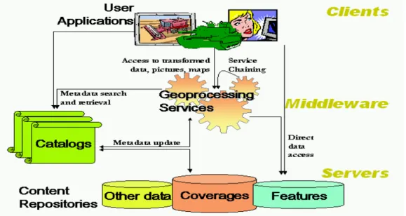
2.3.4 Access Network
Gould et al (2008) state that “Although SDI are primarily institutional collaboration
frameworks, they also define and guide implementation of heterogeneous distributed
information systems, consisting of four main software components linked via
Internet. These components are: 1) metadata editors and associated catalogue
services, 2) spatial data content repositories, 3) client applications for user search and
access to spatial data, and 4) middleware or intermediate geoprocessing services
which assist the user in finding and in transforming spatial data for use at the client
side application.” This is illustrated in Figure 2
Figure 2: High-level SDI architecture, taken from the FGDC-NASA Geospatial Interoperability Reference Model (GIRM), (FGDC, 2003).
2.3.5 People and Partnership
This component includes the spatial data users and suppliers and any value-adding
agents in between, who interact to drive the development of the SDI. For this reason
the formation of cross jurisdictional partnerships has been the foundation of SDI
initiatives supported to date. People are the key to transaction processing and
decision-making. All decisions require data and as data becomes more volatile
human issues of data sharing, security, accuracy and access forge the need for more
defined relationships between people and data. The rights, restrictions and
complex, through compelling and often competing issues of social, environmental
and economic management. Facilitating the role of people and data in governance
that appropriately supports decision-making and sustainable development objectives
is central to the concept of SDI.
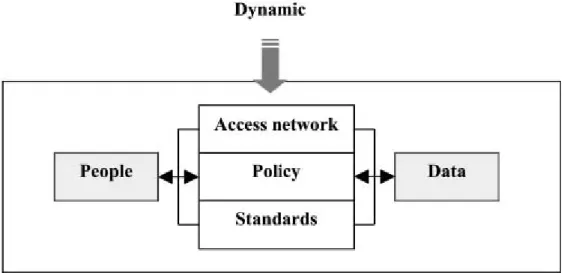
2.3.6 Policies and Institutional Arrangements.
The institutional framework defines the policy and administrative arrangements for
building, maintaining, accessing and applying the standards and datasets, (ANZLIC,
1998). Policies and Institutional Arrangements define other components of SDI such
as governance, data privacy and security, data sharing, and cost recovery, (Nebert,
2006). It is the policies and organizational components that make it possible for the
realization of aims and objective of SDI. Even when data and other components are
in place, without enabling policies, and institutional arrangements, coordination,
cooperation and sharing will not be achieved. Figure 3 illustrates the dynamic nature
and relationships of this SDI Components.
Figure 3: Nature and Relations between SDI Components. ( Rajabifard et al 2003a).
2.4 History of SDI
Like other forms of infrastructures SDI has development history, ‘with every country
development emerged in the mid-1980s when the USA and Australia, for example,
started to develop the data access relationships, which became the precursor to the
development of NSDI initiatives. At this time, countries developing SDI on any
jurisdictional level had only very limited ideas and knowledge about different
dimensions and issues of the SDI concept, and rather less experience of such
development. Within this generation, each country designed and developed SDI
based on their specific requirements and priorities and nationally specific
characteristics. The ultimate objectives of the SDI initiatives in this generation as
summarized by Masser (1999) were to promote economic development, to stimulate
better government and to foster environmental sustainability. A significant milestone
overcome by the first generation, for whom there were few experiences and existing
SDI developments from which to learn, was the documentation of researchers’ and
practitioners’ experiences and status reports on their SDI initiatives and as part of
that report on their clearinghouse activities which facilitated their SDI initiatives.
2.5 Levels of SDI
SDI can be developed at corporate level, local level, state level, national level
(NSDI), regional level and global level. Many countries are developing SDI at
different levels ranging from local to state/provincial, national and regional levels, to
a global level. The objectives of these initiatives are to promote economic
development, to stimulate better government and to foster environmental
sustainability, (Masser, 1998). Rajabifard et al (2000) developed a model of SDI
hierarchy that includes SDI developed at different political-administrative levels.
Based on this model, the SDI hierarchy creates an environment, in which
decision-makers working at any level can draw on data from other levels, depending on the
themes, scales, currency and coverage of the data needed, (Figure 4). The
double-ended arrow in this figure represents the continuum of the relationship between
different levels of detail for the data to be used at the different levels of planning
Fig 4: SDI Hierarchy, Relationships among different levels of SDI and levels of Planning (Adapted from Rajabifard et al, 2000).
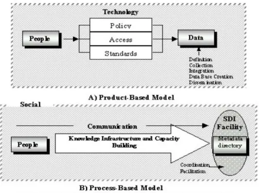
2.6 SDI Development Models
Rajabifard, and Williamson, (2003b), identified two models namely product-based
and process-based that can be identified in contemporary SDI development, as
illustrated in Figure 5. The product-based model (Figure 5A), represents the main
aim of an SDI initiative being to link existing and upcoming databases of the
respective political/administrative levels of the community. The process-based
model, (Figure 5B) presents the main aim of an SDI initiative as defining a
framework to facilitate the management of information assets. In other words, the
objectives behind the design of an SDI, by any coordinating agency, are to provide
better communication channels for the community for sharing and using data assets,
Figure 5: Product and Process based models for SDI development (Rajabifard and Williamson, 2003b).
2.7 National SDI Initiatives
Since the publication of the Executive Order 12906 on ‘Coordinating Geographic
Data Acquisition and Access: The National Spatial Data Infrastructure’ (President
Clinton, USA, 1994), many countries throughout the have initiated NSDI. The goal
of these infrastructures is to reduce duplication of effort among agencies, improve
quality and reduce costs related to geographic information, to make geographic data
more accessible to the public, to increase the benefits of using available data, and to
establish key partnerships with states, counties, cities, tribal nations, academia and
the private sector to increase data availability, (FGDC, 2006). According to
Rajabifard et al, (2003c), ‘the national SDI is an initiative intended to create an
enabling environment for a wide variety of users to access and retrieve complete and
SDI forms a fundamental framework to exchange data across many agencies and
disciplines.’
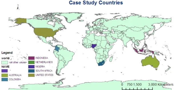
NGDI of Nigeria is the primary case study NSDI. However, in order to have a
comprehensive and comparative analysis of NGDI, other NSDI of other countries
have to be reviewed. Six countries were selected, using the United Nation indices for
human development of 2007 that divided the world into highly developed and
developing nations. From the highly developed world, Australia (ASDI), The
Netherlands (NGII), and United States (NSDI) were selected. From the developing
nations, Colombia (ICDE), Indonesia (INSDI) and Republic of South Africa (NSIF)
were selected. In addition to this development based criteria, the selection reflected
geographical distribution, in that one country was selected from each continent,
(Figure 6).
Figure 6: Map showing case study countries.
2.7.1 Australian Spatial Data Infrastructures (ASDI) - Australia
The Australian Spatial Data Infrastructure (ASDI) is a national framework for
linking users with providers of spatial information. The ASDI comprises the people,
through all levels of government, the private sector, non-profit organizations and
academia.
Busby and Kelly (2004) stated that the Australian Spatial Data Infrastructures is
designed to empower users by facilitating ready access to spatially referenced
information, no matter where it is held. Initiated by the Australian Commonwealth
and State and Territory governments in 1986, under the auspices of ANZLIC–The
Spatial Information Council, the ASDI links SDI that are being established within
each of the nine government jurisdictions throughout Australia. The ASDI is also
reaching out to the private and education sectors and the wider community
Components
Fundamental Datasets
Clarke, et al (2003) stated that one important early initiative was the fundamental
datasets scoreboard project, which was designed to focus attention on the availability
of key reference ASDI datasets. Ten themes were selected for audit –administrative
boundaries, cadastre, elevation, land use, place names, roads, street addresses,
vegetation and water. These datasets are used by multiple GIS applications, and
underpin many spatial products and services.
Access Network
In 1995, ANZLIC established a Metadata Working Group to design and develop a
national spatial data directory system. The Australian Spatial Data Directory (ASDD)
is an online directory that enables people to discover what spatial data is available
throughout Australia. The information contained in the directory is called metadata.
Clarke (2001) states that the clearinghouse component of the ASDI is not well
defined beyond the central role of the ASDD. Busby and Kelly (2004) maintains that
‘Like other national clearinghouse initiatives based on client-server architecture and
largely driven by data providers, the ASDI are proving difficult to sustain in its
Standards
In response to changing user expectations, SDI in Australia are moving towards a
web services model based on new international standards (ISO19115 and OGC
Catalog Service specification). This will better meet the needs of a more aware and
growing user base and make it easier to sustain the commitment to enhanced data
discovery and access.’
Policies
ANZLIC has prepared a set of guiding principles to assist the preparation of a model
spatial data access and pricing policy. The policy is aimed at providing easy, efficient
and equitable access to fundamental spatial data’, (Guiding Principles for Spatial
Data Access and Pricing Policy, 2001). These principles emphasize easy, efficient
and equitable community access and the maximizing of net benefits, and there is
much less variation between jurisdiction pricing policies today, (Clarke, et al 2003).
However, each jurisdiction is responsible for determining its own access conditions
and arrangements. All jurisdictions have worked towards developing data pricing and
access policies. Two recent national developments which underline the trend towards
a more open pro-user spatial data pricing policy within Australian governments are
documented in Clarke, et al, (2003).
Institutional Arrangements
ANZLIC comprises one representative from each of the eight Australian state and
territory governments, one from the Australian Commonwealth Government, and one
from the New Zealand Government. Each of these representatives is the head of the
spatial information coordinating body in their respective jurisdictions, ensuring that
ANZLIC represents all the public sector spatial data agencies.
2.7.2 National Spatial Data Infrastructure - USA
Executive Order 12906 (Coordinating Geographic Data Acquisition and Access: The
National Spatial Data Infrastructure) calls for the establishment of the National
necessary to promote sharing of geospatial data throughout all levels of government,
the private and non-profit sectors, and the academic community. The goal of this
Infrastructure is to reduce duplication of effort among agencies, improve quality and
reduce costs related to geographic information, to make geographic data more
accessible to the public, to increase the benefits of using available data, and to
establish key partnerships with states, counties, cities, tribal nations, academia and
the private sector to increase data availability, (FGDC, 2008). The Federal
Geographic Data Committee (FGDC), established by the President's Office of
Management and Budget to coordinate geospatial data activities, is charged with
coordinating the development of the NSDI through three major activities:
establishment of a National Geospatial Data Clearinghouse; development of
standards for data documentation, collection, and exchange, and development of
policies, procedures and partnerships to create a national digital geospatial data,
(FGDC, 2005).
Components
Since its inception, FGDC has worked to implement the six basic building blocks, or
common elements, of the NSDI: metadata, clearinghouse, standards, framework,
geospatial data, and partnerships. Each of these components serves as a cornerstone
in establishing consistency and structure when it comes to documenting spatial data
for everyday applications, as well as in building a distributed network of producers
and users that facilitate data sharing. Nebert (2006) captures in Figure 7.
Fundamental Datasets
Geospatial data themes providing the core, most commonly used set of base data are
known as framework data. They are geodetic control, orthoimagery, elevation and
bathymetry, transportation, hydrography, cadastral, and governmental units, (NSDI
Framework Factsheet, 2004). The framework is a collaborative community based
effort in which these commonly needed data themes are developed, maintained, and
integrated by public and private organizations within a geographic area. The
NSDI. The framework concept was developed by representatives of county,
regional, State, Federal, and other organizations under the auspices of the FGDC.
Access Network
The FGDC is tasked by Executive Order 12906 to develop procedures and assist in
the implementation of a distributed discovery mechanism for national digital
geospatial data. Geospatial metadata are critical to data discovery and serves as the
fuel for the Geospatial One-Stop data portal and the NSDI Clearinghouse, (FGDC,
2008). The FGDC coordinates the sharing of geographic data, maps, and online
services through an online portal, geodata.gov that searches metadata held within the
NSDI Clearinghouse Network. The geodata.gov portal is operated in support of the
Geospatial One-Stop Initiative to provide “one-stop” access to all registered
geographic information and related online access services within the United States.
The NSDI Clearinghouse Network is a community of distributed data providers who
publish collections of metadata that describe their map and data resources within
their areas of responsibility, documenting data quality, characteristics, and
accessibility. Each metadata collection, known as a Clearinghouse Node, is hosted by
an organization to publicize the availability of data within the NSDI. The metadata in
these nodes is searched by the geodata.gov portal to provide quick assessment of the
extent and properties of available geographic resources, (FGDC, 2008).
Standards
The FGDC develops geospatial data standards for implementing the NSDI, in
consultation and cooperation with state, local, and tribal governments, the private
sector and academic community, and, to the extent feasible, the international
community. The FGDC develops geospatial data standards only when no equivalent
voluntary consensus standards exist, in accordance with OMB Circular A-119. OMB
Circular A-119 directs Federal agencies to participate in voluntary consensus
standards bodies. Some key voluntary consensus standard bodies include ISO
Technical Committee 211 (ISO TC 211), Open Geospatial Consortium (OGC) and
Policies
The U.S. Office of Management and Budget and the U.S. Congress set policy for
Federal agencies. The Federal Geographic Data Committee, a Federal interagency
coordinating committee, is guided by those policies in the design of programs,
activities and technologies. The FGDC sets geospatial information policy in harmony
with overall information policy. Executive Order 12906 is the Presidential Directive
establishing NSDI.
Institutional Arrangements
The FGDC, established by the President's Office of Management and Budget, is
charged with coordinating the development of the NSDI. The FGDC Coordination
Group is comprised of chairpersons of the thematic Subcommittees and 'cross-cut'
Working Groups, and representatives from Federal agencies and FGDC recognized
stakeholder groups.
2.7.3 The National Geographic Information Infrastructure - the Netherlands
“The Dutch NSDI can be described as the result of various initiatives taken in a
bottom-up approach for more than 10 years. Different stakeholders take initiatives
and eventually reach agreements for collaboration and elaboration. Different actors
are actively involved and the NSDI is of a very dynamic nature but was, until recent,
without legal steering”, (INSPIRE State of Play Report, 2007).
The three main providers of geographic information are the Cadastre, the
Topographic Agency, and the Statistical Bureau, (Bas C. Kok and Bastian van
Loenen, 2000).
RAVI, the Dutch council for Real Estate Information, developed the national
structure plan for geo information, approved by the Dutch Council of Ministers in
1992. The main target of this vision was to increase the compatibility and exchange
between the main core data sets. In 1995, RAVI launched a discussion document for
the National Geographic Information Infrastructure (NGII) which is defined in
respect to policy, geographic data sets, technology, standards, knowledge and
education. The case for developing a NGII was also strengthened by the emergency
needs created by the severe flooding that took place in 1995, (SAI Publication,
1999).
Components
Fundamental Datasets
Kok and Loenen states that “the NGII and e-government processes are based on the
concept of core data – data that most people and organizations need in solving
problems. This core data concept is similar to the FGDC’s Framework Data
Concept.” In addition to the cadastral database and socio-economic data, the two
foundation blocks are the 1:10,000 scale maps for the whole country which is being
developed by the Topographic Agency, and the large scale 1:1,000 map being
developed by a consortium including the Cadastre, Dutch Telecom, local
Access Network
It is estimated that there are 36,000 data sets in the public sector of potential use to
others. Documenting these datasets and making them visible to potential users is
therefore a crucial task. For this purpose a National Clearing House Project was
initiated by RAVI in 1995.
“Technically access to the data sets is being provided among others through the
establishment of National Clearinghouse Geo-information (NCGI), an electronic
metadata information desk. The clearinghouse provides a means for finding available
data set, public and private, via the Internet. At the moment the NCGI provides only
metadata, free of charge, contained in a central database. The data sets themselves
are contained at the owning organization, being among others government agencies,
provincial and local authorities”, (Onsrud, 1998). The NCGI promotes the access to
(public) GI; the standardization of metadata; the use of geo-information; the use of
OpenGIS technology.
Institutional Arrangements
Since its initiation, the NGII was coordinated by RAVI, through the foundation
NCGI (in which RAVI has a leading role). RAVI had a scientific advisory board, a
Platform for Public Agencies and Platform for Companies (INSPIRE 2007). RAVI
has been playing a crucial role in developing a vision for an NGII, creating
awareness, and developing political support. Much progress has been made over the
last few years, but given that this organization has no formal powers to compel
public agencies to participate in the plan, developing consensus and sense of purpose
is difficult. In the future, Geonovum will take over the role of RAVI and NCGI.
Policies
The NSDI initiative is partially integrated in legal instruments. The Ministry of
Spatial Planning and Environment, MinVROM has the formal responsibility for GI
related matters in the Netherlands. A Ministerial Decree of 2 June 2006 installed the
GI-Board. Its task is to make recommendations to the minister of housing, spatial
planning and environment and to other ministers and public authorities on strategic
propose frameworks for coordination, infrastructure and conditions for access,
stimulating use, and standardization of spatial information. It should also advise the
government on European and international affairs, and organize projects to improve
the Dutch spatial data
Standards
SAI publication (1999) outlines linking of the core data sets, overcoming the barriers
to data availability, issues of data pricing, data digitization and awareness creation as
some of the burning issues. Netherlands response to the GSDI questionnaire (1998)
highlighted that The RAVI seeks to achieve the status of a node in the European
Geographic Information Infrastructure for the Netherlands and is a member of the
European Umbrella Organization for Geographic Information (EUROGI),and that
the NGII conforms to the EGII and ISO TC211 standards development.
Institutional Arrangements
Geonovum is the National Spatial Data Infrastructure (NSDI) executive committee in
the Netherlands. The organization was founded in 2007 and devotes itself to
providing better access to geo-information in the public sector. Geonovum develops
and manages the geo-standards necessary to implement this goal. The tasks focus in
particular on developing and controlling standards, making up-to-date
geo-information accessible, developing knowledge and giving advice to the Council for
Geo-information on technology and implementation aspects, (Geonovum, 2007).
European Umbrella Organization for Geographic Information (EUROGI)
The emergence of regional spatial data infrastructure organizations began with the
creation of the European Umbrella Organization for Geographic Information
(EUROGI) in 1993 (Masser, 2003). EUROGI is an independently funded,
non-governmental, and non-profit European organization that seeks to develop a
European approach towards the use of geographic information technologies. “Its
mission is to maximize the use of GI for the benefit of citizens, good governance and
commerce. It promotes, stimulates, encourages and supports the development and
Infrastructure for Spatial Information in Europe (INSPIRE)
INSPIRE is an initiative currently being prepared by the European Commission to
support the availability of spatial information for the formulation, implementation
and evaluation of the EU policies. It intends to set the legal framework for the
gradual creation of a spatial information infrastructure.The INSPIRE policy vision is
to make harmonized and high quality geographic information readily available for
formulating, implementing, monitoring and evaluating Community policy and for the
citizen to access spatial information, whether local, regional, national or
international, (INSPIRE EU Directive, 2007).
INSPIRE State of Play (2007) reports that the Dutch Ministry of Spatial Planning
and Environment (MinVROM) assigned Geonovum to execute the INSPIRE
progamme in the Netherlands. Part of this programme is the development of the
Dutch part of INSPIRE network, including national INSPIRE portal, connected to
European INSPIRE portal, filled with geo-data and metadata and properly managed.
2.7.4 National Spatial Information Framework (NSIF) - South Africa
The National Spatial Information Framework (NSIF) is a national initiative
to co-ordinate the development of infrastructure needed to support the
utilization of spatial information in decision making. This building of a
Spatial Data Infrastructure as it is termed in similar
endeavors all over the world, includes policies, institutional arrangements,
developing human resources and standards for geographic information, (NSIF,2008).
The South African Spatial Information Bill was passed on 13th May, 2003 “To
establish the South African Spatial Data Infrastructure, the Committee for Spatial
Information, and an electronic metadata catalogue; to provide for the determination
of standards and prescriptions with regard to the facilitation of the sharing of spatial
information; to provide for the capture and publishing of metadata and the
avoidance of the duplication of such capture;…”, (Spatial Information Infrastructure
Bill, May 2003 Revised) which established the South African Spatial Data
facilitating the capture, management, maintenance, integration, distribution and
utilization
Components
Fundamental Data
The NSIF Directorate, listed the following as Core data sets agreed upon by
geographic information community: Cadastral Boundaries, Land cover,
Hydrographic data, Services and Utilities, Elevation (DEMs), Administrative
Boundaries, Digital Orthophotos.
Access Network
The Spatial Data Discovery Facility (SDDF) is a system for connecting spatial data
users with spatial data sources, so that data can be exchanged. This will prevent
costly duplication of effort in capturing and maintaining spatial datasets, (NSIF,
2008). According to the NSIF, the Spatial Data Discovery Facility (SDDF) is a
“yellow pages” for accessing information about several hundred data sets. Danzfuss
and Bishop (1999) state that the Spatial Data Discovery Facility (SDDF) is a web
based application that allows users to discover the location and/or existence of spatial
data. The design was based on three tier architecture: Database tier, Application tier
and Presentation tier. There is a focus on developing mechanisms to improve access
to existing information, avoid duplication in data collection and management and
ensure that new data captured can be easily utilized together with existing geographic
data, to enhance their collective values.
Standards
There is not much available data on standards component of South African NSDI.
Policies
In South Africa, the Directorate, NSIF is mandated to promote the development of
operation on 28th of April, 2006. The SII Bill was published in Government Gazette
No.25973, vol. 464 on 4th February 2004, and signed into operation by the President
on 28th April, 2006.
Institutional Arrangements
The NSIF provides the parameters for a coherent national spatial data infrastructure
and promote the utilization of spatial information in South Africa.
The NSIF is mandated to co-ordinate the development of infrastructure needed to
support the utilization of spatial information in decision making. There are NSIF
membership comprising surveyors, planners, geographers, IT technologist and three
Working Groups or Task Teams on: policies, standards, and marketing and
education.
2.7.5 Infraestructura Colombiana de Datos Espaciales (ICDE)-Colombia
The Colombian Spatial Data Infrastructure, (Infrastructura Colombiana de Datos
Espaciales, ICDE) is defined as the set of policies, standards, organizations and
technology working together to produce, share, and use geographic information
about Colombia in order to support national sustainable development. The ICDE is a
young but promising initiative.
In the 1990's, an awareness of the benefits of geographic information started to grow
in Colombia among municipalities, environmental agencies, oil companies, and the
utilities sector, (GSDI Cookbook v.2, 2004). Colombian government agencies that
have the mandate to produce geographic information are outlined in the GSDI
Cookbook v.2, 2004. The development of NSDI in Colombia (ICDE) is a joint
venture between various agencies and driven by the nation’s programmes for
governance to address national issues related to the environment, the economy, and
Components
Main ICDE components may be defined as: administrative information policies and
guidelines, geographic information standards including metadata, fundamental data,
and a national geographic information network. (GSDI Cookbook v.2, 2004).
Response to GSDI questionnaire (1998) indicated existence of metadata,
clearinghouse, data standards, and core data.
Fundamental Datasets
Colombia Response to GSDI questionnaire (1998) identified the following basic
datasets in building the national geographic database: Ground control points,
transportation, hydrography, cadastre, relief, vegetation, land use, administrative,
political areas, and geosciences.
Access Network
There is metadata availability in ICDE, and access mechanism is through the
websites of the participating institutions. There is no clearinghouse yet.
Standards
A working group on standards and metadata is in place. A national geographic
metadata standard was defined in March 1999 and standardization efforts are linked
to ISO TC 211 and FGDC.
Policies
In Colombia, there is no formal mandate for the establishment and implementation of
NSDI (Eelderink, 2006, GSDI Survey, 1998). According to Eelderink report,”IGAC
guides the process but no official leader has been appointed.IGAC realizes that
high-level support seems to be the major area requiring further efforts. No formal legal
agreements exist to address issues such as privacy, access, use, pricing and liability”.
Institutional Arrangements
There are well educated GIS/SDI experts in Colombia. The Centre of Research and
courses. In the 1990s, NSDI awareness started to grow in Colombia, and presently
most of the public institutions know about ICDE and understand its importance.
2.7.6 National Spatial Data Infrastructure in Indonesia
The vision of Indonesian Spatial Data Infrastructure (ISDI) is “to make the national
fundamental datasets available, accessible and integrated in one national data
standard”, (Terima Kasih, 2005). Masser (2005) stated that in 1993, an interagency
working group was established to identify the most important land data users and
producers to establish a national geographic information system for planning
purposes in Indonesia.Bakosurtanal, the National Coordinating Agency for
Surveying and Mapping, coordinated the working group.
Components
Fundamental Datasets
Under the Indonesian National Spatial Data Infrastructure (NSDI)'s concept, the
fundamental datasets and the thematic data sets will be made available. The
fundamental data sets comprises of geodetic framework; topographic databases,
cadastral databases and bathymetric databases, (GSDI Survey, 1998). The geodetic
control network includes the National Geodetic horizontal, vertical and gravity
control networks spanning the whole Archipelagoes of Indonesia (more than 17.000
islands, large and small). Other than this, various thematic data bases cover
International and National Boundaries, Land and Marine resources data bases,
Indonesian Economic Exclusive and Continental shelf data bases, etc. Most of the
fundamental data sets, as well as the thematic data sets, are available in digital
format. Government institutions produce most data; the government requires that all
producers deliver data to users. However, most data is produced for their own use,
data is not well managed, and there is little awareness to disseminate data, (Matindas,
Access Network
Matindas et al (2004) indicated that there is little awareness to disseminate data, and
there is no data directory or metadata. The development of the clearinghouse is a
long and complex process because it involves a large number of datasets, many data
producing institutes and quite a number of professionals. The FGDC standard has
been adopted for the collection of metadata. The access network can be accessed
through the website of Bakosurtanal.
Standards
The FGDC standards have been adopted. However, the existence of standardized
metadata in almost all data producing institutes is inappropriate, (Puntedewo and
Nataprawira, 2004). In the second phase of the SDI initiative (2005-2009), Indonesia
started with the development of a National Spatial Information System for the
standardized data collection. However, regulations seem not to be available yet.
Policies
In July 2007, establishment of NSDI was institutionalized by a presidential decree.
The NSDI will benefit the entire sector as it would provide spatial data not only of
central. Government and provincial governments but also up local government level.
The data will be available on the net for the government and private sectors.
Recommendations for the establishment of legal aspects and policy within the
Indonesian SDI are described in Abdulharis et al, (2005). A long term vision
document (up to 2020) is also available.
Institutional Arrangement
One of the mission statements of Badan Koordinasi Survei dan Pemetaan Nasional –
BAKOSURTANAL (National Coordinating Agency for Surveying and Mapping) is
“to build National Spatial Data Infrastructure (NSDI), which covers elements of
institution, regulation standard, spatial fundamental data, human resources,
research and technology of surveys and environment for national
Bakosurtanal is the coordinator of the Indonesian SDI, and it carries out this function
in collaboration with other agencies. Bakosurtanal has broken down the development
of the infrastructure in phases. In 2001, the first phase started with the development
of the SDI nodes, databases and metadata, a clearinghouse and standards. The
following phase, which started in 2005, focuses on the improvement of coordination
mechanisms; the completion of the spatial databases and national metadata
developments, and the activities of the clearinghouse. Bakosurtanal have developed a
long term NSDI vision, up to 2020. Issues such as the implementation of local
clearinghouses and the maintenance of spatial fundamental data, and standards have
been taken into considerations.
2.8 Summary and Conclusions
In this chapter, the status of NSDI of Australia, USA, Netherlands (developed
countries) and South Africa, Colombia and Indonesia (developing countries) were
reviewed. Tables summarizing each of these respective NSDI are presented in
Appendix 1.
This chapter has defined some fundamental concepts and terminologies within the
field of Spatial Data Infrastructures. We have identified and selected six nations with
their NSDI at different development continuum, and analyzed them with a view to
finding the driving forces behind the initiatives, their present status and future
direction.
The analysis of the definitions of SDI by respective NSDI is similar, and their
fundamental (core) datasets are similar. On the driving forces behind the initiatives,
there is however some variations between developed countries and developing
countries. While the major driving force is to promote data sharing and reduce
duplication in the developed world, it is to promote awareness in the use of
geo-information to address national issues such as governance and environment in
developing countries.
Access Network are better developed in countries of United States and The
Netherlands with the presence of apex clearinghouse, while other countries in less
the NSDI have no formal mandate such as Colombia, and the Netherlands. One thing
in common with all the reviewed NSDI is that their development is a continuous
process as awareness and technology improves. Having reviewed the status and
direction of the selected case study countries, an abridged version of comparative
analysis of their summary is presented in Table 1, while more comprehensive
CASE STUDY COUNTRIES
Developed World Developing World
SDI COMPONENT SPECIFIC VARIABLES Au stra lia Uni te d St at es Neth erla nd s So ut h Af ri ca Co lomb ia In d onesi a Ni geri a Data Core datasets Data Format Updating Resolution Defined Digital Yes Different Defined Digital Yes Different Defined Digital Yes Different Defined Digital Yes Different Defined Digital Yes Different Defined Digital Yes Different Defined Analogue Yes Two Scales Access Network Metadata Access Mechanism Network Architecture Clearinghouse Yes Yes 25 distributed nodes Not well defined Yes Yes Distributed data providers Yes Yes Yes Web based architecture Yes Yes Yes
Web based with several nodes Yes Yes Yes LAN/Internet in institutions Yes Yes Yes Network Gateway No No Central Server Standards Data Transfer Transfer Standard Interoperability Arranged ISO 19115,OGC Yes Arranged FGDC,ISO TC211,OGC Yes Arranged EGII,ISO TC211 Yes No Data FGDC,ISO, SDI ACT No Arranged ISO TC 211 FGDC No Arranged FGDC No Not Arranged SON,ISO Standards No
Policy Coordinating Body SDI Directive Data Access and Pricing
Yes Yes Yes Yes Yes Yes Yes Yes Yes Yes Yes Yes No No No Yes Yes Yes Yes No Yes Institutional Arrangements Coordinating Body Participating Agencies Working Groups Present Yes No Present Yes Yes Present Yes No Present No Yes Present Yes Yes Present Yes Not Defined Present Yes No
3.
The NGDI and Research Methodology
3.1 Introduction
The National Geospatial Data Infrastructures of Nigeria (NGDI) is an NSDI initiative
that among other objectives is to promote the production, dissemination and use of
geospatial information for poverty alleviation, food security, job creation,
improvement of quality of life, good governance, education and health care delivery,
water resources management, environmental and disaster management,
transportation, tourism, communications, gender mainstreaming, national defense
and security, economic planning and natural resources management.
Other objectives include the discovery, harmonization and standardization of
geospatial data production and management, and the provision of a platform for data
sharing thereby eliminating data duplication and conserving cost and time spent in
producing already available data, (Agbaje and Akinyede, 2005). An efficient
functioning NGDI and the associated GI Policy is regarded as vital requirements for
sustainable national development.
This chapter focuses on the National Geospatial Data Infrastructure (NGDI) of
Nigeria: the development of the NGDI from policy formulation, stakeholders,
organization, problems, challenges and prospects as documented in the literature will
be presented. The chapter will also present research methodology adopted in this
study.
3.2 Nigeria at a Glance
Nigeria, officially named the Federal Republic of Nigeria is a federal constitutional
republic comprising thirty six states and one Federal Capital Territory. There are 774
local government areas in the country. The country is located in West Africa and
shares land borders with the Republic of Benin in the West, Chad and Cameroon in
the East, and Niger in the North. Its coast lies on the Gulf of Guinea, part of the
surface area of 923,768km2 (Figure 8). It has a population estimate of 148 million
people comprising about 250 ethnic groups.
Fig 8: Location map of Nigeria, (©Oxford Cartographers, 2008)
Nigeria has a varied landscape. From the Obudu Hills in the southeast through the
beaches in the south, the rainforest, the Lagos estuary and savanna in the middle and
southwest of the country and the Sahel and the encroaching Sahara Desert in the
extreme north. Nigeria is also an important center for bio- diversity. Nigeria’s main
rivers are the Niger, the Benue which converge and empty out in the Niger Delta, one
of the world's largest river deltas. As a federal state, it has three-tier government: the
federal, the state, and the local government, all coordinated by the ministries,
3.3 NGDI & National Geoinformation Policy
3.3.1 The Driving forces
Due to the increasing awareness of the use of GI for decision-making over the past
years, coupled with the expected availability of primary dataset from the Nigerian
Satellite, the country has realized the need to adopt policies for promoting greater
awareness and public access to standard and coordinated geo-spatial data production,
management and dissemination by all sectoral institutions and the need for the
establishment of a Geospatial Data Clearinghouse at various levels in the country
(local, state and federal) and linkages with the private sectors. Other driving forces
include: New Partnership for Africa’s Development (NEPAD)-provision of relevant
GI to facilitate national development and regional integration; call of the United
Nations Economic Commission for Africa (UNECA) to establish SDI, and
Information and Communication Technology as it permits GI sharing and growth.
In September, 2003, the final draft of Nigerian Geoinformation Policy was
formulated by the Federal Ministry of Science and Technology, Abuja. The vision of
the GI Policy is to enhance optimal use of Geospatial Information as a critical
resource in all phases of sustainable national development for the alleviation of
poverty and improvement of quality of life of the people of Nigeria by establishing
and maintaining an NGDI, (National Geoinformation Policy). The references to this
section unless otherwise stated refer to National Geoinformation Policy.
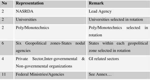
3.3.2 The NGDI Organization
The mission of the NGDI, among others is to generate and disseminate geospatial
databases, which are vital for development at the National, State and Local levels in
Nigeria by facilitating cooperation and collaboration among GI stakeholders. To
achieve these objectives, the National GI Policy has provided for the establishment