www.biogeosciences.net/7/71/2010/
© Author(s) 2010. This work is distributed under the Creative Commons Attribution 3.0 License.
Biogeosciences
A spatial resolution threshold of land cover in estimating terrestrial
carbon sequestration in four counties in Georgia and Alabama, USA
S. Q. Zhao1,2,*, S. Liu3, Z. Li2, and T. L. Sohl3
1College of Urban and Environmental Sciences, Peking University, Beijing 100871, China
2Arctic Slope Regional Corporation (ASRC) Research and Technology Solutions, Contractor to US Geological Survey
(USGS) Earth Resources Observation and Science (EROS) Center, Sioux Falls, SD 57198, USA
3USGS EROS Center, Sioux Falls, SD 57198, USA *Work performed under USGS contract 08HQCN0007
Received: 17 July 2009 – Published in Biogeosciences Discuss.: 5 August 2009
Revised: 14 December 2009 – Accepted: 17 December 2009 – Published: 7 January 2010
Abstract. Changes in carbon density (i.e., carbon stock per unit area) and land cover greatly affect carbon sequestration. Previous studies have shown that land cover change detection strongly depends on spatial scale. However, the influence of the spatial resolution of land cover change information on the estimated terrestrial carbon sequestration is not known. Here, we quantified and evaluated the impact of land cover change databases at various spatial resolutions (250 m, 500 m, 1 km, 2 km, and 4 km) on the magnitude and spatial patterns of re-gional carbon sequestration in four counties in Georgia and Alabama using the General Ensemble biogeochemical Mod-eling System (GEMS). Results indicated a threshold of 1 km in the land cover change databases and in the estimated re-gional terrestrial carbon sequestration. Beyond this thresh-old, significant biases occurred in the estimation of terrestrial carbon sequestration, its interannual variability, and spatial patterns. In addition, the overriding impact of interannual climate variability on the temporal change of regional carbon sequestration was unrealistically overshadowed by the im-pact of land cover change beyond the threshold. The implica-tions of these findings directly challenge current continental-to global-scale carbon modeling efforts relying on informa-tion at coarse spatial resoluinforma-tion without incorporating fine-scale land cover dynamics.
Correspondence to:S. Q. Zhao ([email protected])
1 Introduction
Various approaches have been proposed to study the role of the terrestrial biosphere on regulating CO2concentration
assimilating land cover change information into simulations over large areas (Houghton et al., 1999; Prentice et al., 2001; Achard et al., 2004; Ramankutty et al., 2007). In a previous study (Zhao et al., 2009), we investigated the possible biases in quantifying carbon exchange between the land and atmo-sphere caused by ignoring detailed fast-changing dynamics of land cover, using the General Ensemble biogeochemical Modeling System (GEMS). GEMS can dynamically assim-ilate land cover change information into the simulation pro-cess over large areas. We found that ignoring the detailed fast-changing dynamics of land cover can lead to a significant overestimation of carbon uptake by the terrestrial ecosystem (Zhao et al., 2009). Given the inherent heterogeneity of land-scapes at various spatial scales, modeled carbon exchange between the land and atmosphere may vary with the spatial resolution or grain size of land cover information. There-fore, the present study was conducted to examine the possi-ble influence of spatial resolution of land cover change in-formation on the estimation of terrestrial carbon sequestra-tion in four counties in Georgia and Alabama, USA over the period 1992–2007, using the GEMS model, coupled with land cover information at spatial resolutions of 250 m, 500 m, 1 km, 2 km, and 4 km.
2 Methods
2.1 Study area
The study area, with a total area of 3852 km2, is located along
the border of Georgia and Alabama, United States, consisting of Chattahoochee, Marion, and Muscogee Counties in Geor-gia and Russell County in Alabama (Fig. 1). The climate is subtropical with an annual mean precipitation of 1245 mm and annual mean air temperature of 17.8◦C between 1972 and 2007. Forest is the dominant land cover in the region (∼75%). Most of the forests are intensively managed for timber production, resulting in rapid turnover between clear-cutting and regenerating forest. The city of Columbus, Geor-gia, and the Fort Benning military complexes account for much of the developed land, and agricultural land and wet-land accounted for much of the rest. Because of the hetero-geneity of land cover and short rotational forestry, this area is ideal for investigating how the spatial grain size of land cover change maps affects carbon dynamics at the regional scale.
2.2 Model description
To simulate the impacts of land use change and spatial res-olution of land use change maps on regional carbon sources and sinks, it is apparent that the underlying model should have the capability of simulating carbon dynamics over large areas with explicit incorporation of dynamic land use change information. GEMS, developed to upscale carbon stocks and fluxes from sites to regions, is one of such models (Liu et al., 2004a). GEMS has the potential of taking control
Fig. 1.The study area in Georgia and Alabama. Nearly 75% of the study area is forested, with cropland, wetland, and developed land covering most of the rest of the region.
probability density functions of the biophysical properties, were performed to transfer input data uncertainty into GEMS output. More detailed descriptions of the model can be found in Liu et al. (2004a, b) and Liu (2010).
2.3 Land cover change database
Consistent, high-quality, and spatially explicit land cover change databases at 250-m by 250-m resolution were de-veloped using the FORE-SCE (FOREcasting SCEnarios of future land cover) model (Sohl et al., 2007). FORE-SCE can project future land use changes from spatial and temporal characteristics of historical land cover change and probability-of-occurrence surfaces for each unique land cover type. In this study, FORE-SCE relied heavily on the data generated by the US Geological Survey’s Land Cover Trends project (Loveland et al., 2002) for model parame-terization. Specifically, FORE-SCE projections were based on extrapolation of annual “prescriptions” of key land use change variables derived from the Land Cover Trends project (e.g., the rates of change for individual land cover types, like-lihood of specific land cover transitions, and basic character-istics of patch size) from the 1992–2000 time period to 2001– 2007. Logistic regression was used to develop probability-of-occurrence surfaces for each land cover type based on bio-physical and socioeconomic drivers related to land use type at a given location. Individual patches of new land cover were placed on the landscape in an iterative process until the annual scenario prescriptions had been met. Patch sizes of land use change were uniquely assigned by approximating the historical distribution of patch sizes for each land cover type in the region. The process continues with yearly itera-tions to create a history of variable tracking age classes for forest and other classes. A more detailed description of the model can be found in Sohl and Sayler (2008).
To investigate the potential influence of spatial resolution of land use change data on carbon sequestration, we used land cover information at five spatial resolutions (250 m, 500 m, 1 km, 2 km, and 4 km). The spatial resolution of the original land cover dataset was 250 m, and the land cover maps were resampled to grain sizes of 500 m, 1 km, 2 km, and 4 km. We understood that different sampling approaches may produce different results. However, the difference was not the focus of our study. We were interested in detecting a threshold, if any, that is a spatial characteristic of the land cover change activities in the region and that is independent of sampling approaches. To find the threshold, the sampling approach should be the most effective among all possible sampling approaches in retaining finer-scale land cover in-formation (composition and transitions) as the spatial scale becomes coarser. In this study, we used the frequently used majority sampling (MS) approach and the nearest neighbor sampling (NNS) approach to resample the land cover data. Results clearly show the NNS approach was much better than the MS approach in retaining finer-scale land cover change
information (Fig. 2). As a result, the land cover data resam-pled using the NNS approach was selected as the basis for this study.
2.4 Carbon stocks, NPP, and Geospatial Data Layers
Key forest parameters were derived from the Forest Ser-vice’s Forest Inventory and Analysis (FIA) database (http: //fia.fs.fed.us/tools-data/default.asp). The estimates of net primary productivity (NPP) and carbon stock were used for model validation, and forest age distribution, mortality, and selective cutting were used for model parameterization (see Liu et al., 2004a). The stock and annual increment of above-ground live biomass carbon density, natural mortality, and se-lective and clear-cut harvesting were derived from all the FIA field plots of 21 inventories (spanning from 1970 to 2005) in the southeastern United States.
NPP of any forest inventory plot was estimated using the common assumption that annual root production equals an-nual fine litterfall (Raich and Nadelhoffer, 1989; Jenkins et al., 2001):
NPPi=2Li+Gi
whereLi is annual fine litterfall, andGi is the annual incre-ment of aboveground woody components, including stems and branches. According to the above equation, the average NPP of forests at the county level can be estimated by: NPP=2L+G
where NPP,L, andGare county-wide mean NPPi,Li, and
Gi, respectively. The values ofGfor the counties were esti-mated from the FIA database. The average annual fine litter was estimated to be 2 Mg C ha−1yr−1 in this region on the basis of Meldahl et al. (1998) and Jenkins et al. (2001). Be-lowground biomass C stock in live roots was estimated using the regression equation for temperate forests (Cairns et al., 1997). Estimated belowground biomass C stock was then added to the aboveground estimate to produce an estimate of total biomass C stock.
73
Fig. 2. Temporal changes in area percentage of forest, cropland, urban, and transitional barren from 1992 to 2007 at different spatial resolutions resampled using the nearest-neighbor and majority resampling approaches.
assessed using forest stands that were inventoried in both the current and historical databases. Other data used in this study are listed in Table 1.
2.5 Model simulations
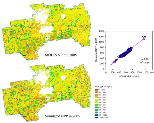
Adequately representing the spatial variability of NPP is a key challenge in simulating the impacts of land use change on carbon sequestration from landscape to regional scales. NPP in EDCM is estimated by multiplying site-specific po-tential NPP with scalars representing the impacts of environ-mental factors such as temperature, moisture, and nutrient status. It is impossible to manually parameterize EDCM with realistic site-specific potential NPP values over a large area. We developed a data assimilation approach to inversely cal-culate spatially explicit potential NPP from Moderate Reso-lution Imaging Spectroradiometer (MODIS) NPP from 2000
Table 1.Other geospatial data layers used in this study.
Variables Data source
Climate
monthly minimum temperature, monthly maximum temperature, and monthly precipitation
http://www.prism.oregonstate.edu/products/
Soil
soil texture, bulk density, organic matter content, wilting point, and field capacity
http://soils.usda.gov/survey/geography/ssurgo/
drainage classes http://edna.usgs.gov/Edna/datalayers/cti.asp
Forest
species composition, forest age, and biomass distribution data
http://fia.fs.fed.us/tools-data/default.asp
Cropping practices
shares of various crops and rotation probabilities
http://www.nrcs.usda.gov/technical/NRI/
Total atmospheric nitrogen deposition
http://nadp.sws.uiuc.edu/
y = 0.99x R2 = 0.86
0 200 400 600 800 1000 1200 1400
0 200 400 600 800 1000 1200 1400 MODIS NPP in 2005
S
im
ul
a
ted N
P
P
i
n 200
5
2.6 Analysis
Current year carbon sequestration was calculated as the difference between the current year’s and previous year’s ecosystem carbon stock (including carbon accumulated in live biomass, forest floor, and soil), which was equal to net biome productivity (NBP) using the carbon cycle concepts and terminology of Chapin et al. (2006). Positive values rep-resent uptake, and negative values indicate carbon loss from the biome.
To quantify the impact of spatial resolution of land cover change information on estimating carbon sequestration, we used the carbon sequestration estimates at the finest tion (250 m) as the base for comparison. The spatial resolu-tion at which carbon sequestraresolu-tion characteristics (e.g., mean and variability measures) demonstrated significant changes from the base would be considered the critical spatial resolu-tion. To find the critical resolution, we calculated the abso-lute relative change of a carbon sequestration metricδi:
δi=
Ci−C250 m
|C250 m|
whereCj is the mean, minimum, maximum, or standard de-viation of the annual carbon sequestration rates at spatial res-olutioni(i=250 m, 500 m, 1 km, 2 km, and 4 km). To facili-tate comparison across different statistics, we normalizedδi:
1i=
δi
max{|δ250 m|,|δ500 m|,|δ1 km|,|δ2 km|,|δ4 km|}
×100%
3 Results
3.1 Influence of spatial resolution on land cover
Forest was the dominant land cover type in the region (>75%), followed by cropland and urban areas. Combined, they accounted for more than 90% of the study area. The transitional barren category, caused primarily by forest har-vesting, was closely associated with the dynamics of forest. We analyzed the detailed area changes of these four land cover types with the degradation of spatial resolution over the period 1992–2007 (Fig. 2, based on NNS). Overall, the area of forestland and cropland decreased while urban area expanded based on the 250-m resolution data.
The overall temporal pattern of land cover change re-mained unchanged as the resolution coarsened from 250 m to 1 km. In addition, the magnitudes or compositions of land cover showed little change among these spatial resolutions. In contrast, as the resolution coarsened from 1 km to 4 km, these four land cover types demonstrated apparent changes in magnitude, suggesting changes in land cover composi-tion (Fig. 2). For the year 1992, for example, as the resolu-tion coarsened from 1 km to 4 km, urban area increased from 5.6% to 6.9%, forest area decreased from 79.1% to 77.2%, and cropland increased from 6.7% to 8.5%.
The transitional barren coverage was not significantly af-fected by the change in spatial resolution from 250 m to 1 km. As the spatial resolution was further coarsened to 2 km and 4 km, the interannual variation in the area percentage of tran-sitional barren became pronounced, and even the original pattern was altered when the spatial resolution degraded to 4 km (Fig. 2). Although the long-term average percentage of transitional barren did not change significantly, the coef-ficient of variability (i.e., standard deviation divided by the mean) increased from 0.29 to 0.88. Since the transitional barren was caused primarily by forest harvesting, the inter-annual variation in transitional barren corresponded closely with the variation in forest. At the resolution of 4 km, tran-sitional barren coverage was anomalously high in 2004 and anomalously low in 2002 and 2003. Correspondingly, forest was anomalously low in 2004 and anomalously high in 2002 and 2003 (Fig. 2).
3.2 Influence of spatial resolution on carbon sequestration
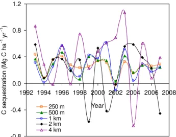
As the spatial resolution degraded from 250 m to 500 m, 1 km, 2 km, and 4 km, the estimated mean carbon sequestra-tion rate during the study period changed from 0.27 to 0.26, 0.27, 0.18, and 0.40 Mg C ha−1yr−1, respectively. The car-bon sequestration rate remained relatively stable (normalized relative change1within 10%) when the resolution changed from 250 m to 1 km (Figs. 4 and 5). It changed drastically and unpredictably, however, when the resolution was fur-ther degraded to 4 km. The change was a decrease of 33% from 1 km to 2 km but an increase of 48% from 1 km to 4 km (Fig. 4). The results suggest that a critical threshold of spatial resolution for estimating carbon sequestration in the region was larger than 1 km but smaller than 2 km, corresponding well with the land cover change threshold described above. Beyond this critical resolution, the estimated regional carbon sequestration rate became unreliable.
-0.8 -0.4 0.0 0.4 0.8 1.2
1992 1994 1996 1998 2000 2002 2004 2006 2008
Year
C
s
eques
tr
at
ion (
M
g C
ha
-1
yr
-1 )
250 m 500 m 1 km 2 km 4 km
Fig. 4. Temporal changes of carbon sequestration between 1992 and 2007 for five spatial resolutions.
under spatial resolutions of 250 m, 500 m, 1 km, 2 km, and 4 km, respectively. An intermediate change in the minimum rate was detected (1=15%) from 500 m to 1 km, and a dra-matic change from 1 km to 2 km (1>90%). The change of maximum annual carbon sequestration was gradual, but it increased significantly from 0.44 to 0.47, 0.62, 0.59, and 1.07 Mg C ha−1yr−1as the spatial resolution coarsened. The maximum annual carbon sequestration changed dramatically (1=29%) from 500 m to 1 km. That the standard devia-tion of annual carbon sequestradevia-tion changed from 0.12 to 0.13, 0.21, 0.39, and 0.43 Mg C ha−1yr−1also suggested that the critical spatial resolution threshold was from 500 m to 1 km (1=29%). All the evidence from variability metrics (i.e., minimum, maximum, and standard deviation) clearly demonstrated significant changes (1from 15 to 29%) in the temporal variability of carbon sequestration from 500 m to 1 km, and larger changes (1=24%–90%) when resolution changed from 1 km to 2 km. The results indicated that a res-olution between 500 m and 1 km was the critical spatial reso-lution for adequately characterizing the interannual variabil-ity of carbon sequestration at the regional scale. Beyond the threshold, the interannual variability would be exaggerated.
The critical resolution between 500 m and 1 km for tempo-ral variability was smaller but close to the critical threshold (larger than 1 km but smaller than 2 km) for mean carbon se-questration. For simplicity, we refer to 1 km as the critical threshold for estimating carbon sequestration in the region in the rest of the paper despite the small difference for mean and variability.
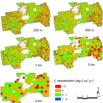
The spatial distributions of the average rate of carbon se-questration between 1992 and 2007 at the five spatial resolu-tions showed a high degree of spatial heterogeneity (Fig. 6). At 250-m resolution, the carbon sequestration map showed detailed spatial patterns and variability. As the spatial
reso--100 -80 -60 -40 -20 0 20 40 60 80 100
Mean Minimum Maximum Standard Deviation
Descriptive statistics of annual C sequestration rates from 1992 to 2007
N
o
rm
aliz
ed
r
ela
tiv
e c
h
an
g
e (%
)
250 m 500 m 1 km 2 km 4 km
Fig. 5. Normalized relative change of the mean, minimum, max-imum, and standard deviation of carbon sequestration rates as the spatial resolution of land cover information changed from 250 m, to 500 m, 1 km, 2 km, and 4 km.
lution was coarsened, many spatial details of carbon seques-tration disappeared (Fig. 6). Averaging across all the years for all pixels, the minimum mean carbon sequestration rate at the pixel level in the region was −15.9, −14.1, −13.0,
−10.9, and−9.0 Mg C ha−1yr−1as the resolution changed from 250 m to 4 km, and the maximum changed from 3.8 to 3.6, 3.0, 2.7, and 2.3 Mg C ha−1yr−1. This clearly shows that aggregating land cover information in space diminished the range of spatial variability of simulated carbon sequestra-tion on the landscape. Our results highlight the necessity of characterizing land cover changes that influence carbon ex-change between the terrestrial biosphere and the atmosphere using spatially explicit information at the scale where land cover change activities happen (i.e., at the field scale).
4 Discussion
Fig. 6.The distributions of carbon sequestration between 1992 and 2007 for five spatial resolutions. White represents urban/residential areas (mainly Columbus in the central north) and the cantonments in the installation (i.e., two big contiguous areas at the central south and the right). These areas were masked because of lack of input data or proper understanding of the underlying processes.
Several previous studies have documented the effects of spatial resolution on land cover classification/mapping and consequent carbon exchange between the terrestrial biosphere and the atmosphere. For example, Kimball et al. (1999) found that NPP was strongly sensitive to land cover spatial scale due primarily to land cover aggregation ef-fects on the representation of deciduous and coniferous life-forms. Jung et al. (2007), on the other hand, documented that the spatial land cover resolution has little effect on mod-eling gross primary productivity over Europe. However, both of these studies used a general ecosystem process model, Biome-BGC, which is incapable of dynamically assimilating land cover change information into the simulation process across large spatial extents. This represents a limitation in the ability to use such models to examine the possible im-pacts of the spatial resolution of land cover maps over time. In addition, Turner et al. (2000) reported detailed effects of alternative spatial resolution on land cover mapping over a managed forest landscape in western Oregon and evaluated its influences on the estimation of NPP and net ecosystem productivity using a simple bookkeeping approach. Unfor-tunately, this approach was unable to capture the spatial and temporal influences of land cover change information on car-bon fluxes. Our study relied on consistent and spatially ex-plicit land cover change databases and a robust biogeochemi-cal modeling system that is capable of dynamibiogeochemi-cally
assimilat-ing land use change information into the simulation process across large spatial extents (Liu et al., 2003, 2004a, b; Liu, 2010; Tan et al., 2005, 2006, 2007).
This study showed that the coarsening of spatial resolu-tion in land cover databases altered land cover patterns and ignored the spatial details of land cover change, resulting in significant biases in estimated terrestrial ecosystem carbon sequestration. Our results also indicated that a resolution threshold of 1 km existed in the study area, and beyond this critical threshold not only the magnitude but also the general patterns of land cover and carbon sequestration would be al-tered. This finding has important implications for continental to global carbon studies because most modeling efforts rely heavily on land cover data at coarse spatial resolution (often coarser than 0.5◦grid cells) (e.g., Schimel et al., 2000; Hurtt
et al., 2002; Krinner et al., 2005). Two issues should be ad-dressed properly at the continental and global scales. First, is the threshold of 1 km found in this study still valid as we deal with modeling efforts at the continental and global scale? The critical threshold value of 1 km might be universal be-cause most of the land disturbances and management activi-ties occur at or below this spatial scale. However, more stud-ies should be performed to confirm or disprove the generality of this finding in other areas or other land cover resampling approaches. The issue of spatial resolution is not only related to the estimation of carbon sequestration as demonstrated in this study but also relevant to any surveys on forests and land use activities such as estimating timber reserves, forest area, or regional biodiversity (Crawley and Harral, 2001; Hame et al., 2001; Chase and Leibold, 2002).
Second, approaches for upscaling carbon dynamics at the plot scale to global scale with adequate assimilation of land cover change dynamics at the finer spatial resolution have to be developed at continental to global scales. Without proper upscaling techniques, significant errors can be introduced to the estimated spatial and temporal changes of carbon seques-tration. Our study showed that beyond the threshold of 1 km, the magnitude and the interannual variability of carbon se-questration estimates differed significantly from those within the threshold. In addition, the overriding effect of interannual climate variability on the temporal change of regional carbon sequestration was unrealistically overshadowed by the im-pacts of land cover change once the threshold was crossed. Nevertheless, there were efforts to bring land cover change information into global biogeochemical models using tem-poral fractional changes of land cover within each grid cell or pixel (Sitch et al., 2003; Zaehle, 2005; Jung et al., 2007; Bondeau et al., 2007; Strassmann et al., 2008). However, these approaches are not sufficient because they only simu-lated impacts of the net land use changes rather than detailed gross land use transitions at the grid cell level. The conse-quence of this treatment is not known.
than a property associated with the specific land cover resam-pling approach we used. We used the land cover data gener-ated from using the nearest-neighbor resampling approach because it effectively retained finer-scale land cover change information as the scale became coarser (Fig. 2), a require-ment for detecting the threshold of land cover resolution. The frequently used majority sampling approach was not suitable for threshold detection because it could not effectively retain land cover change information across scales. The errors in model simulations caused by different resampling schemes, especially the most popular majority resampling approach, and remedy measures should be further investigated.
Land cover change is critical in determining the distri-bution, magnitude, and mechanisms of terrestrial carbon sources and sinks at local to global scales (Canadell, 2002; Houghton, 2003; Kauppi et al., 2006). More importantly, it is critical to examine land cover change and its subsequent influence on carbon sequestration at the scale where land cover change activities occur. Otherwise, it is impossible to accurately quantify biological carbon sequestration potential and to further formulate strategies to mitigate global climate change.
Acknowledgements. This study is supported by the Department
of Defense’s Strategic Environmental Research and Development Program (SERDP) (project SI-1642), and US Geological Survey’s Geographic Analysis and Monitoring (GAM) and the Earth Surface Dynamics (ESD) Programs. S. Q. Zhao acknowledges the support of the Outstanding Young Fellow Program of Peking University.
Edited by: A. Arneth
References
Achard, F., Eva, H. D., Mayaux, P., Stibig, H. J., and Belward, A.: Improved estimates of net carbon emissions from land cover change in the tropics for the 1990s, Global Biogeochem. Cy., 18, GB2008, doi:10.1029/2003GB002142, 2004.
Binford, M. W., Gholz, H. L., Starr, G., and Martin, T. A.: Regional carbon dynamics in the southeastern U.S. coastal plain: Balancing land cover type, timber harvesting, fire, and environmental variation, J. Geophys. Res., 111, D24S92, doi:10.1029/2005JD006820, 2006.
Bondeau, A., Smith, P. C., Zaehle, S., Schaphoff, S., Lucht, W., Cramer, W., Gerten, D., Lotze-Campen, H., Muller, C., Reich-stein, M., and Smith, B.: Modelling the role of agriculture for the 20th century global terrestrial carbon balance, Glob. Change Biol., 13, 1–28, 2007.
Brown, S., Schroeder, P., and Birdsey, R.: Aboveground biomass distribution of US eastern hardwood forests and the use of large trees as an indicator of forest development, Forest Ecol. Manage., 96, 37–47, 1997.
Cairns, M. A., Brown, S., Helmer, E. H., and Baumgardner, G. A.: Root biomass allocation in the world’s upland forests, Oecologia, 111, 1–11, 1997.
Canadell, J. G.: Land use effects on terrestrial carbon sources and sinks, Science in China Series C-Life Sciences, 45, 1–9, 2002.
Chapin, F. S., Woodwell, G. M., Randerson, J. T., et al.: Reconcil-ing carbon-cycle concepts, terminology, and methods, Ecosys-tems, 9, 1041–1050, 2006.
Chase, J. M. and Leibold, M. A.: Spatial scale dictates the productivity–biodiversity relationship, Nature, 416, 427–430, 2002.
Crawley, M. J. and Harral, J. E.: Scale dependence in plant biodi-versity, Science, 291, 864–868, 2001.
Fang, J. Y., Chen, A. P., Peng, C. H., Zhao, S. Q., and Ci, L.: Changes in forest biomass carbon storage in China between 1949 and 1998, Science, 292, 2320–2322, 2001.
Garten, C. T. and Ashwood, T. L.: Land Cover Differences in Soil Carbon and Nitrogen at Fort Benning, Georgia, ORNL/TM-2004/14, Oak Ridge National Laboratory, Oak Ridge, TN 37831, 2004.
Goodale, C. L., Apps, M. J., Birdsey, R. A., et al.: Forest carbon sinks in the Northern Hemisphere, Ecol. Appl., 12, 891–899, 2002.
H¨ame, T., Stenberg, P., Anderson, K., Rauste, Y., Kennedy, P., Folv-ing, S., and Sarkeala J.: AVHRR-based forest proportion map of the Pan-European area, Remote Sens. Environ., 77, 76–91, 2001. Houghton, R. A., Hackler, J. L., and Lawrence, K. T.: The US car-bon budget: Contributions from land-use change, Science, 285, 574–578, 1999.
Houghton, R. A.: Revised estimates of the annual net flux of carbon to the atmosphere from changes in land use and land manage-ment 1850–2000, Tellus B, 55, 378–390, 2003.
Houghton, R. A. and Goodale, C. L.: Effects of land-use change on the carbon balance of terrestrial ecosystems, in: Ecosystems and land use change, edited by: DeFries, R. S., Asner, G. P., and Houghton, R. A., American Geophysical Union, Washing-ton, DC, 85–98, 2004.
Hurtt, G. C., Pacala, S. W., Moorcroft, P. R., Caspersen, J., Shevli-akova, E., Houghton, R. A., and Moore III, B.: Predicting the future of the U.S. carbon sink, P. Natl. Acad. Sci. USA, 99, 1389– 1394, 2002.
Jenkins, J. C., Birdsey, R. A., and Pan, Y.: Biomass and NPP esti-mation for the mid-Atlantic region (USA) using plot-level forest inventory data, Ecol. Appl., 11, 1174–1193, 2001.
Jung, M., Vetter, M., and Herold, M., et al.: Uncertainties of modeling gross primary productivity over Europe: A system-atic study on the effects of using different drivers and terres-trial biosphere models, Global Biogeochem. Cy., 21, GB4021, doi:10.1029/2006GB002915, 2007.
Kauppi, P. E., Ausubel, J. H., Fang, J. Y., Mather, A. S., Sedjo, R. A., and Waggoner, P. E.: Returning forests analyzed with the for-est identity, P. Natl. Acad. Sci. USA, 103, 17574–17579, 2006. Kimball, J. S., Running, S. W., and Saatchi, S. S.: Sensitivity of
bo-real forest regional water flux and net primary production simu-lations to sub-grid-scale land cover complexity, J. Geophys. Res., 104(D22), 27789–27801, 1999.
Krinner, G., Viovy, N., de Noblet-Ducoudre, N., Ogee, J., Polcher, J., Friedlingstein, P., Ciais, P., Sitch, S., and Prentice, I. C.: A dynamic global vegetation model for studies of the cou-pled atmosphere-biosphere system, Global Biogeochem. Cy., 19, GB1015, doi:10.1029/2003GB002199, 2005.
American Geophysical Union, in press, 2010.
Liu, S., Bliss, N., Sundquist, E., and Huntington, T. G.: Model-ing carbon dynamics in vegetation and soil under the impact of soil erosion and deposition, Global Biogeochem. Cy., 17, 1074, doi:10.1029/2002GB002010, 2003.
Liu, S., Loveland, T. R., and Kurtz, R. M.: Contemporary carbon dynamics in terrestrial ecosystems in the Southeastern plains of the United States, Environ. Manage., 33, S442–S456, 2004a. Liu, S., Kaire, M., Wood, E., Diallo, O., and Tieszen, L. L.: Impacts
of land use and climate change on carbon dynamics in south-central Senegal, J. Arid Environ., 59, 583–604, 2004b.
Loveland, T. R., Sohl, T. L., Stehman, S. V., Gallant, A. L., Sayler, K. L., and Napton, D. E.: A strategy for estimating the rates of recent United States land-cover changes, Photogramm. Eng. Rem. Sens., 68, 1091–1099, 2002.
McGuire, A. D., Sitch, S., Clein, J. S., et al.: Carbon Balance of the Terrestrial Biosphere in the Twentieth Century: Analy-ses of CO2, Climate and Land Use Effects with Four
Process-Based Ecosystem Models, Global Biogeochem. Cy., 15, 183– 206, 2001.
Meldahl, R. S., Kush, J. S., Rayamaijhi, J. N., and Farrar Jr., R. M.: Productivity of natural stands of longleaf pine in relation to competition and climatic factors, in: The productivity and sus-tainability of southern forest ecosystems in a changing environ-ment, edited by: Mickler, R. A. and Fox, S., Springer-Verlag, New York, 231–235, 1998.
Myneni, R. B., Dong, J., Tucker, C. J., et al.: A large carbon sink in the woody biomass of northern forests, P. Natl Acad. Sci. USA, 98, 14784–14789, 2001.
Parton, W. J., Schimel, D. S., Cole, C. V., and Ojima, D. S.: Analy-sis of factors controlling soil organic matter levels in Great Plains grasslands, Soil Sci. Soc. Am. J., 51, 1173–1179, 1987. Prentice, I. C.: The carbon cycle and atmospheric carbon
diox-ide, in: Climate Change 2001: The Scientific Basis, edited by: Houghton, J. T. and Ding, Y. H., Cambridge Univ. Press, Cam-bridge, 183–237, 2001.
Quaife, T., Quegan, S., Disney, M., Lewis, P., Lomas, M., and Woodward, F. I.: Impact of land cover uncertainties on esti-mates of biospheric carbon fluxes, Global Biogeochem. Cy., 22, GB4016, doi:10.1029/2007GB003097, 2008.
Raich, J. W. and Nadelhoffer, K. J.: Belowground carbon allocation in forest ecosystems: global trends, Ecology, 70, 1346–1354, 1989.
Ramankutty, N., Gibbs, H. K., Achard, F., et al.: Challenges to estimating carbon emissions from tropical deforestation, Glo. Change Biol., 13, 51–66, 2007.
Reiners, W. A., Liu, S., Gerow, K. G., Keller, M., and Schimel, D. S.: Historical and future land use effects on trace gas emissions using an ensemble modeling approach: Costa Rica’s Caribbean Lowlands as an example, Global Biogeochem. Cy., 16, 1068, doi:10.1029/2001GB001437, 2002.
Schimel, D., Melillo, J., Tian, H., et al.: Contribution of increasing CO2 and climate to carbon storage by ecosystems in the United States, Science, 287, 2004–2006, 2000.
Schimel, D. S., House, J. I., Hibbard, K. A., et al.: Recent patterns and mechanisms of carbon exchange by terrestrial ecosystems, Nature, 414, 169–172, 2001.
Sitch, S., Smith, B., Prentice, I. C., Arneth, A., Bondeau, A., Cramer, W., Kaplan, J. O., Levis, S., Lucht, W., Sykes, M. T., Thonicke, K., and Venevsky, S.: Evaluation of ecosystem dy-namics, plant geography and terrestrial carbon cycling in the LPJ dynamic global vegetation model, Glob. Change Biol., 9, 161– 185, 2003.
Sitch, S., Brovkin, V., von Bloh, W., van Vuuren, D., Eickhout, B., and Ganopolski, A.: Impacts of future land cover changes on atmospheric CO2and climate, Global Biogeochem. Cy., 19,
GB2013, doi:10.1029/2004GB002311, 2005.
Smith J. E., Heath, L. S., and Woodbury, P. B.: How to estimate forest carbon for large areas from inventory data, J. Forest., 102, 25–31, 2004.
Smith, J. E., Heath, L. S., Skog, K. E., and Birdsey, R. A.: Methods for calculating forest ecosystem and harvested carbon with stan-dard estimates for forest types of the United States, US Forest Service General Technical Report NE-GTR-343, 216 pp., 2006. Strassmann, K. M., Joos, F., and Fischer, G.: Simulating effects of
land use changes on carbon fluxes: past contributions to atmo-spheric CO2increases and future commitments due to losses of terrestrial sink capacity, Tellus, 60B, 583–603, 2008.
Tan, Z., Liu, S., Johnston, C. A., Loveland, T. R.,Tieszen, L .L., Liu, J. X., and Kurtz, R.: Soil organic carbon dynamics as related to land use history in the Northwestern Great Plains, Global Bio-geochem. Cy., 19, GB3011, doi:10.1029/2005GB002536, 2005. Tan, Z., Liu, S., Johnston, C. A., Liu, J. X., and Tieszen, L. L.: Analysis of ecosystem controls on soil carbon source-sink rela-tionships in the northwest Great Plains, Global Biogeochem. Cy., 20, GB4012, doi:10.1029/2005GB002610, 2006.
Tan, Z., Liu, S., Li, Z. P., and Loveland, T. R.: Simulated responses of soil organic carbon stock to tillage management scenarios in the Northwest Great Plains, Carbon Balance Manage., 2(7), doi:10.1186/1750-0680-2-7, 2007.
Turner, D. P., Cohen, W. B., and Kennedy, R. E.: Alternative spatial resolutions and estimation of carbon flux over a managed forest landscape in western Oregon, Landsc. Ecol., 15, 441–452, 2000. Zaehle, S.: Process-based simulation of the European terrestrial biosphere – An evaluation of present-day and future terrestrial carbon balance estimates and their uncertainty, PhD thesis, Uni-versitat Potsdam, Potsdam, Germany, 2005.