Abstract— A system is proposed here concerning actions for children to take when a disaster occurs. The actions children should take while commuting in a disaster can be input by parents as instructions. Parents can verify their child’s school route and means of transportation, and any possible accidents. They can consider concrete countermeasures against them and then resister them on the system screen. They actually use the system themselves and can verify the validity of the content. A child can also use the system when an earthquake occurs. The system was created for use on a laptop PC and a wireless LAN. The results of evaluation experiments indicated two particular points: dangerous objects on school routes could be confirmed for parents and the awareness of disaster prevention for children improved. The conclusion was drawn that the system proved useful.
Index Terms— disaster prevention, school routes, parents, children
I. INTRODUCTION
APAN frequently has earthquakes, with it therefore being known as an “earthquake country.” as the mass media has recently reported that major possible future earthquakes include a Tokai Earthquake, Tonankai Earthquake, Nankai Earthquake, and a Tokyo Metropolitan Earthquake. According to a database compiled by the Japan Meteorological Agency from 02/07/2010 through to 01/07/2011 small earthquakes occurred 35 times in Osaka prefecture and 47 times in Shiga prefecture. The data then indicates that earthquakes, even if only small, occur 3 to 4 times every month. The data also suggests the strong likelihood that elementary schoolchildren could be exposed to an earthquake within their school zone. Countermeasures against disasters need to be considered by the people themselves who could be exposed to one. However, elementary school students have limits to what they can take into consideration themselves on how to deal with an earthquake, thus making it necessary that their parents do so. The hope with this system is that it will be of support to any such parents. The South Hyogo prefecture Earthquake in 1995 recorded a seismic intensity of 7 in Kobe. The scale of the intensity was considered to be only 6 at the time, but a seismic intensity of 7 established at a later date [1]. The
Manuscript received July 15, 2011; revised August 01, 2011. This work was supported by Ritsumeikan University.
K. Tsuji and Y. Nakatani are with the Graduate School of Science and Engineering, Ritsumeikan University, Kusatsu city, Shiga, 525-8577 Japan
(e-mail: [email protected]) (e-mail: [email protected]).
estimated population of 0 to 14 years old in Hyogo prefecture on October 01, 1994 was about 910,000, of whom about 400 died [2]. This is less than 10 percent of the total fatalities, but still significant. 362 0 to 19 year olds also died in Kobe city [3]. It is difficult for resulting damage to children to be focused upon and most questionnaires on damage after earthquakes have a focus on adults and the elderly. There are more dangers present indoors than outdoors, although that changes depending on where people are when an earthquake occurs. This proposed system therefore indicates actions children should take when a disaster occurs. Instructions which children should act upon while commuting in a disaster can be input by their parents. The system provides an environment through which parents can plan and prepare beforehand for a disaster.
II. CHILD ORIENTED DISASTER PREVENTION RESEARCH
Disaster prevention measure research to date has focused on disaster prevention education, the maintenance of disaster preventive manuals, and the maintenance and dissemination of evacuation routes, etc. The activities of highlighting and providing warnings also take place in frequently flooded areas and danger zones, for example any areas prone to landslides, using disaster prevention or hazard maps. Adults can respond to sudden earthquakes via use of those measures whereas elementary schoolchildren typically cannot.
A. Development of Education Programs and Materials for Disaster Mitigation and Preparedness using Victims’ Experiences in Local Historical Disasters
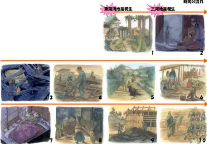
Kimura and Hayashi developed an educational program and materials for elementary school students [4]. The Tokai region in Japan has had the two strong earthquakes of the Tonankai Earthquake on December 7, 1944, and the Mikawa Earthquake January on 13, 1945, 37 days later.
They made a survey via semi-structured interviews of people who had experienced the earthquakes.
That reasons for that are provided below.
i. The inland earthquake occurred about a month after the inter-plate earthquake. The aspect of the earthquake occurring is appropriate in Japan as it is typically a precedent to heightened activity.
ii. Journals scarcely recorded the process of livelihood rehabilitation from the earthquake disaster after the South Hyogo prefecture Earthquake in 1995. The study was appropriate as cases of earthquake which resulted in so much damage can be compared against The South Hyogo prefecture Earthquake.
Disaster Planning Support System for Parents
and Their Children while on the Way to School
Kosuke Tsuji, Yoshio Nakatani
The situation of the damage, disaster correspondence, and livelihood rehabilitation identified through interview were depicted as paintings by an artist. A technique of arranging the paintings using a time axis was then developed Kimura and Hayashi as disaster educational materials for children.
This then provided the following special features.
i. The paintings provided the children with concrete images concerning disasters that have very little records of them like movies or pictures.
ii. The paintings provide knowledge and precepts that are hard to put into words but which children can then visualize.
iii. People not interested in disasters become interested in them.
iv. The younger generations, for example young children and students, can easily gain knowledge on disasters. v. They can compare and consider other knowledge and
precepts as a picture via one unit.
Sisters that suffered from the earthquakes, roughly of the same age, were the target of the interview. The content of the interview involved the true story of their experiences and were then used in disaster education materials for the upper grades of elementary school.
They experimented on the children using the below 10 situations in the same order.
Fig. 1. Paintings as disaster education materials
The study process was provided as part of the 4 grade system as a feature for children studying disaster prevention. Apathy, awareness, correct understanding, accurate decisions, and actions to take in a disaster are all included. A representative phenomenon with it is that it is easy to induce awareness in children if it includes a story that focuses on humans. An example of this is a biography that shows how a man thinks, acts, and changes as time goes on. No explanation about the laws and principles of natural phenomena is included and instead the actual experiences of victims over time are used as educational materials in inducing awareness of children. The above worksheet was made to connect to understanding knowledge on and the precepts of disasters by bringing up and turning over each situation after a disaster while viewing some paintings. The teachers in charge implementing the lessons provided the following evaluation: “It is useful materials to use with children because they can be reminded of the story of the
victims by taking advantage of the paintings being in parallel to the course of time after the disaster. In addition, the content can be considered to be precepts to disaster prevention. ”
B. Problems of usual studies to be solved
Prior education for children is very important but it can be difficult to predict exactly what will occur and thus how well children will react when they only have inexpert or even limited disaster preventive knowledge and limited disaster preventive training. Teaching lessons that aids in the perception of children via paintings is thus very effective. However, they can be costly and slightly unreal to some children, thus making a lower cost and more general techniques needed. Parents providing the necessary guidance can enable children to make more effective decisions and take the appropriate actions in a timelier manner when an earthquake occurs. The purpose of this study was therefore solving the above questions and problems.
III. SYSTEM OVERVIEW
This system is assumed to be of use on children’s school routes. Disaster prevention systems need to be tailored to the individual situations of children. Children are capable acting calmly in the event of a small-scale earthquake, for example an intensity of 1 – 3, if they have conversed about being prepared at home, and have at least been exposed to disaster prevention education at school. However, children may not be capable of acting appropriately if they do have not conversed about being prepared at home, and disaster prevention education at schools can be insufficient unless the appropriate methodology is used. It is important for children, who cannot always make the right judgments, to get reliable concrete instructions. Children typically rely on their parents the most, with parents knowing their children’s situation the best. In this study, therefore, parents set instructions to follow when a disaster occurs with their children’s individual situation taken into account.
This system is practical in that it takes the concrete individual situations of children into account, unlike conventional disaster prevention manuals like above.
This study envisions the following tasks. i. Parents identify their child’s school route.
ii. Parents identify their child’s means of transportation. iii. Parents identify possible accidents.
iv. Parents consider concrete countermeasures against the possible accidents and then register them on the system. v. Parents actually use the system themselves and verify
the validity of the content.
vi. The child uses the system when an earthquake occurs.
A. Obtaining present location
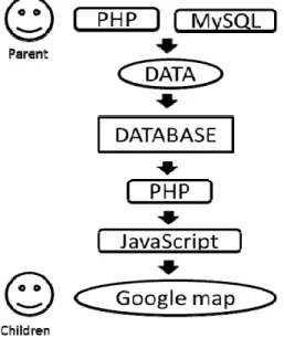
B. PlaceEngine
The current location uses PlaceEngine, a service provided by Koozyt Inc. PlaceEngine enables users to easily estimate their current location via Wi-Fi devices, thus allowing them to find out more about their surroundings and gain access to local information. Any device equipped with Wi-Fi can easily be used estimate its location. PlaceEngine uses Wi-Fi information sent from Wi-Fi access points, thus enabling a device to determine its location both indoors and
underground, where it might normally not be possible with GPS [5]. The precision is vastly improved if users register new locations into the PlaceEngine database.
Wireless communication is typically in hot demand after an earthquake has occurred. It also proved a great success in the Tohoku Earthquake of March 11th. In Tokyo, away from the hypocenter of the great tremor, most people utilized wireless communication via laptop PCs or Smartphones.
C. Input into the system by parents
There is a lot of information that needs to be input into the system by parents. First their home and elementary school need to be nominated on a map. The content to be registered includes five dangerous topics managed on a database. The content includes the names of dangerous objects, photos of them taken by the parents, arrows to indicate the direction children should evacuate in, the latitude and longitude that are automatically obtained from their present location, and comments on evacuating which provide concrete instructions to children. Figure 2 shows a sample system display screen concerning dangerous objects to be input by parents.
Fig. 2. Sample system display screen
Routes judged safe from home to school by parents can also be specified and displayed on the map using different colors, which children can use to judge how to deal with any immediate dangers, confirm a safe route, and identify their present location. Figure 3 depicts a typical map.
Fig. 3. Sample safe evacuation route
Fig. 4. Input into the system by parents function
The next figure (figure 4) reveals the system architecture on how parents are related to the system. Parents who select a simulation mode and walking route with the system can then confirm what where and how instructions to display.
Fig. 5. Image of input into the system by parents
D. Use of the system by parents
This system is expected simultaneously available when an earthquake occurs. When the system first starts up “PlaceEngine” identifies the children’s present location.
The center of Google Maps is displayed as their present location. Information on safe routes that was input by parents is also displayed on the map.
The children basically do very little to the system. Possible operations include just the two matters of displaying other information or part of a non-visible map. “PlaceEngine” identifies the present location of children at all times while the children are evacuating.
IV. RESULTS
The system was evaluated by 3 housewives living in Shiga prefecture in Japan and their 4 elementary school boys. While they could not be expected to provide expert evaluations they were able to put the system to practical use and provide 29 surveys on disaster evacuations. Before using the system all the parents stated that they did not know of any dangerous spots or objects on their child’s school route, as discussed below.
i. If an earthquake occurs on the way to school the students still have to get to school. However, I do not know the danger spots along their route.
ii. All the students need to quickly evacuate to a public hall. However, I have never thought about any dangerous objects along the route.
iii. I typically do not know if our children have dropped in somewhere for a short visit.
However, after using the system the parent realized that anything unexpected could be a danger on the child’s school route.
The following TABLE Σ displays the necessary time for input into the system by parents. This evaluator needs 10 minutes by foot to get from home to the elementary school, and input 5 objects as being possibly dangerous.
One parent did not spend much time on identifying any dangerous objects and instead emphasized comments on the direction of evacuation when she input dangerous objects into the system. Schools typically decide school routes beforehand and oblige students to go to school in groups, revealing the care taken with the safety of the children. It follows from this that school routes typically have few dangerous objects along them.
Fig. 6. Example of the system being used by parents
One parent input the dangerous objects, as in figure 6, into the system. First she input the name of a “shop”, and then the direction to take to seek refuge. The picture was taken from the height of child. The part attached to the wall has only three screws at the head of the signboard and two lower down, which is why the structure is dangerous. In addition, it could be very dangerous in an earthquake because all the screws are rusty. The sentence ‘Enter the Murakami orthopedic surgery’ is written in the comment box. People are always present at the hospital due to the consultation hours being when the students pass by, which is the reason the parent used it as an evacuation site.
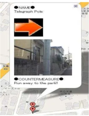
Next another parent input a dangerous object using a picture (figure 7). It was named “Telegraph Pole”, and the direction children should seek refuge was established as being to the right. “Run to the park” was written in the comment box. To the left of the telegraph pole is a wall so children have to escape to the park to the right of it, which is why this parent established this evacuation site.
TABLEI
TIME NEEDEDFOR INPUT BY PARENTS
Task Elapsed Time Time to input dangerous object 40 min
Fig. 7. Example of the system being used by parents
Before using the system the children also answered that evacuation training only took place at school, and hence they did not know how to evacuate when outdoors. However, after using the system they answered that they now realized how to evacuate when outdoors if an earthquake were to occur. The result of surveys revealed that children can find reading maps difficult. The children also provided the following opinions concerning maps via the surveys.
i. I do not have the opportunity to read maps (3rd grade). ii. I often look at an atlas in class but seldom look at road
maps (6th grade).
iii. We are accustomed to looking at maps if we understand how to view them because we often look at maps on video games (4 children).
The children initially found reading the map difficult. However, children can recognize the route to take if their home and school are displayed on a map beforehand. Conversely however, it can be very difficult for children to recognize their route on a map, even if they walk to school using the same route every day. And while they do get the opportunity to look at maps they do not seem to have had many chances to read a map for the purpose of using it. 6th grade students appear to be more accustomed to reading maps, and for that reason more education or training for schoolchildren in lower grades needs to take place. TABLE
Τ shows the time wasted by children.
The above revealed some information on disaster education and how to evacuate immediately from an actual spot was obtained in some surveys. The conclusion was that
the system had proved useful.
One parent answered on a questionnaire that “I might not be able to identify the position of my child.” Including a mail function is therefore needed as a future task. If children were to be exposed to an earthquake on their way to school their parent could figure out their rough position using the input information. However, it would be better to where their child is using the function of the child’s latitude and longitude being sent to the parent’s mobile phone from PlaceEngine. Not only their latitude and longitude but a picture of the place using Google map could also be sent. This would then enable the position of children to be constantly identified and make it easy for parents to search for them when the system starts. Next concerns the map display. How could classes be provided on utilizing maps at elementary school? There is insufficient research in this currently. If something easier to understand for children than a map were to be used, for example street view, by the system, what would the resulting evaluation be? This task also needs to be examined in the future.
V. CONCLUSION
This research targeted a system of which the purpose was parent and child disaster prevention and pre-educational status. The content includes the two points of parents being able to input dangerous objects and a safe route into system identified in the field, which children can then use with no special knowledge. PlaceEngine was adopted for use in the system rather than GPS, and hence their present location can be constantly identified via wireless LAN. Future challenges include making easy to understand maps for children, and the system covering the areas of others via the sharing of information about the school routes of others, i.e. not only their own routes but also others routes.
ACKNOWLEDGMENT
Our deepest appreciation goes to the parents and children who participated in the experiments. This research was supported in part by a grant as part of a Strategic Research Foundation Grant-aided Project for Private Universities made available by the Ministry of Education, Culture, Sport, Science, and Technology, Japan (MEXT), 2010-2014 (S1091040).
REFERENCES
[1] Japan Meteorological Agency. (2011, June 29). Summary of Tables
explaining the JMA Seismic Intensity Scale. Available:
http://www.jma.go.jp/jma/en/Activities/earthquake.html
[2] Ministry of Health, Minister's Secretariat Statistics and Information
Department. The death situation from viewpoint of vital statistics on
The South Hyogo prefecture Earthquake in Japanese, 1995, pp. 1. [3] Mitaka, Fire Information Res. Center Regional disaster prevention
data overview. The South Hyogo prefecture Earthquake edited by fact
data in Japanese, 1997, pp. 7.
[4] Reo KIMURA, Haruo HAYASHI “Development of Education Programs and Materials for Disaster Mitigation and Preparedness using Victims’ Experiences of Local Historical Disasters” ,Institute of Social Safety Science Journal, 2009
[5] Koozyt. (2011, June 28). PlaceEngine. Available: http://www.placeengine.com/en
TABLEΤ
TIME USED BY CHILDREN
Task Elapsed Time Confirmation of input dangerous object 25 min