to r. u fc. b r 1984-2201
Copyright © 2002, Universidade Federal do Ceará
FROM THERE TO HERE, THE DAS CONTAS
RIVER DRAWING... ITS LANDSCAPES
(*) CORRESPONDING AUTHOR
Address: UESC, Rodovia Jorge Amado, km 16, CEP: 45662900, Ilhéus (BA), Brasil. Telefone: (+ 55 73) 36805112 E-mail: jaque@uesc.br
ABSTRACT
The inspiration for writing this poetic essay was the pictorial-poetic image of the Das Contas River, re-presenting the landscapes drawn along its banks. The essay aims to make a geographical reading of this waterway, interpreting and analyzing its landscape, based on its pictorial representation. To and fro…
from the source to the mouth ... or from west to east, the Das Contas River lows approximately 500 km
in the Bahia, connecting three biomes: the Cerrado, the Caatinga and the Atlantic Forest. It is born on the
Tromba mountain range in the municipality of Piatã, and lows into the Atlantic Ocean, in front of the city
of Itacaré, in southern Bahia. These images were analyzed using the phenomenological method, relating their reading and interpretation to the understanding of the landscape as perceived by us and lived by the people who sail on its waters and inhabit its banks, going beyond reality to the meaning of the river, its essence. The main landscapes represented range from the green mountains of the Chapada Diamantina, passing through the yellow Caatinga of Bahia’s hinterlands to the green landscape of the Cabruca Forests (an agro forestry system intercropping cocoa with the forest), in the Atlantic Forest on the south coast of Bahia.
Keywords: Das Contas River, pictorial-poetic image, landscape.
RESUMO/ RESUMEN
DE LÁ PARA CÁ, O RIO DAS CONTAS DESENHANDO... SUAS PAISAGENS
A inspiração para a escrita desde ensaio poético foi a imagem pictórico-poética do rio das Contas,
repre-sentando as paisagens desenhadas ao longo de suas margens. Objetiva fazer uma leitura geográica dessa estrada hídrica, em direção à interpretação e análise da sua paisagem, a partir da sua representação pictórica. De lá para cá... da nascente à foz... ou de oeste a leste, o rio das Contas percorre, aproximadamente, 500
km na Bahia, conectando três biomas: Cerrado, Caatinga e Mata Atlântica. Nasce na serra do Tromba, em
Piatã, e deságua no Oceano Atlântico, na cidade de Itacaré, no sul da Bahia. A análise dessa imagem seguiu
os caminhos da fenomenologia, relacionando sua leitura e interpretação à compreensão das paisagens
per-cebidas por nós e vividas pelas pessoas a navegarem suas águas e habitarem suas margens, indo além da
realidade ao sentido do rio, sua essência. As principais paisagens representadas vão do verde das montanhas da Chapada Diamantina, passando pela caatinga amarela do sertão baiano, até a paisagem novamente verde
da cabruca (cultivo do cacau consorciado com loresta), na Mata Atlântica no litoral sul baiano.
Palavras-chave: Rio das Contas; Imagem pictórico-poética; Paisagem.
DE ALLÁ PARA ACÁ, EL RÍO DE CUENTAS DIBUJANDO… SUS PAISAJES
La fuente de inspiración para escribir este ensayo poético fue la imagen pictórico-poética del Río de Cuentas, representando los paisajes dibujados a lo largo de sus orillas. El ensayo quiere hacer una lectura
geográica de esta ruta luvial, hacia la interpretación y el análisis de sus paisajes, con base en su represen
-tación pictórica. De allá para acá... desde la naciente a la boca... o de oeste a este, el Río de Cuentas corre aproximadamente 500 km en la Bahía, conectando tres biomas: Cerrado, Caatinga y Mata Atlántica. Nace en Tromba, municipio de Piatã, Chapada Diamantina y desemboca en el Océano Atlántico, en la ciudad de Itacaré, sur de Bahía. El análisis de esta imagen fue hecha por medio de la fenomenología, relacionando la
lectura e interpretación a la comprensión del paisaje percibido por nosotros y vivida por las personas que
navegan por sus aguas y habitan en sus orillas, yendo más allá de la realidad hacia el signiicado del río,
su esencia. Los principales paisajes van desde las verdes montañas de la Chapada Diamantina, atravesando
la caatinga amarilla del semiárido Bahiano y retornando a un paisaje verde de bosque de cabruca (cultivo intercalado de cacao con bosque), en la Mata Atlántica en la costa sur de Bahía.
Palabras clave: Río de Cuentas, Imagen pictórico-poética, Paisaje.
CHIAPETTI, Rita Jaqueline Nogueira;a *
(a) DSc in Geography, Lecteur University State of Santa Cruz (UESC). http://lattes.cnpq.br/3991631209906844
A rti cl e h is tor y: Re ce ive
d 31 D
ec em be r, 2016 A cc ept
ed 2 F
ebrua ry , 2017 P ubl is he
r 15 M
ay
w
w
w
.me
rca
to
INTRODUCTION
The river tells man what he must do.
And man follows the river’s orders. Otherwise, he succumbs (MELLO, 1987, p. 24).
According to the epigraph that begins this text, we must obey the river in order not to perish. So, following its order, in this text we navigate with our rudder facing the course of the (not always)
torrential stream of the Das Contas River, having as our artistic support its pictorial-poetic image, as a representation of its landscape from there to here, that is, from the source to the mouth or from
west to east. The purpose of this text is to make a geographical reading of the Das Contas River
and to interpret and analyze its landscape from its pictorial representation.
We consider the waters of the Das Contas River rising on the summit of a mountain to give life to the people of its river basin, as rivers are for the brilliant artist-painter-scientist Leonardo Da Vinci, as in his paintings rivers represent the veins of the human body or veins of the Earth, making an analogy between the human body and the Earth’s body. In this conception, rivers are more than simply water courses... they are life-givers, they are the Earth’s veins, as Bachelard (2002, p. 65) thinks water: “[...] must command the earth. It is the Earth’s blood. The life of the Earth. It is water that will drag the whole landscape to its own destiny”. For the same author, the waters of the rivers, maternal waters, female waters are compared with a mother’s love, immensely large, eternal and
projected into ininity...
Water seduces us with its vital energy, awakening poetic images translated into aquatic sym-bolism. For Dardel (2011), the waters that emerge from rivers are life-giving waters, the ultimate
symbol of life or a fountain of youth. Oliveira (2002) corroborates the statement about water as a
symbol of life, making itself present to guarantee our biological life. For Chevalier and Gheerbrant
(2007, p. 781): “[...] the river always symbolizes human existence and the course of life, with the
succession of desires, feelings and intentions [...]”.
A river is connected to its low ... to the continuous movement of its stream of water, leading
its waters to its destination ... which may be another river, a lake or the sea. The same banks that separate, even if it is only an apparent separation, can unite, delimit, separate or join, depending
on people or our perception. This is the Das Contas River, a river that lows through the lands of
Bahia... a vein that rises delicately like a stream of water on a mountain in the Chapada Diamantina, gaining more water on the surface, running in depressions and plateaus for more than 500 km from west to east, donating life or living conditions to the people who made and make our Bahia, until
reaching its mouth in the south coast of Bahia, where the mangrove swamps and mudlats on its
banks are essential to human life.
According to Chiapetti (2009), along its length, the Das Contas River connects three biomes: the Cerrado in the Chapada Diamantina (young river), the Caatinga in the sertão (mature river)
and the Atlantic Forest in the area closest to the coast (mature and old river). In the irst biome (Cerrado), the river lows for approximately 135 km, in the second (Caatinga) for about 230 km and in the third biome (Atlantic Forest) for around 125 km. It is diicult to estimate its width and depth throughout the course, but in the Atlantic Forest it is approximately 30 m from one margin
to the other, with an estimated depth of 3 m. In the section near its mouth it is around 200 m wide, with a good depth, although at low tide it displays many sandbars (deposits of sand in the form of cords that cause the silting of its bed).
The main tributaries that give their waters to the Das Contas River on the right bank are:
to
r.
u
fc.
b
r
mainly due to the rigors of the semi-arid climate of the sertão in Bahia, where there is water loss by evaporation, contributing considerably to the decrease of the water volume in this section, since most of its tributaries are intermittent in the Cerrado and Caatinga biomes. However, within the Atlantic Forest its water volume increases due to the generosity of its tributaries and the amount of rain that falls regularly during almost the whole year in this biome (CHIAPETTI, 2009).
The Das Contas River is not just one of the ive main rivers in Bahia, which is born in an oasis within its semi-arid region, that is, the Chapada Diamantina, lowing through the sertão without its
waters drying out and providing the subsistence of the population of the sertão... that navigates the
forest telling the sertão’s secrets... before inally emptying into the sea. It is also a historic river,
like all the great rivers that are references to society. In ancient times, boats loaded with food na-vigated its waters ensuring the survival of many people in the villages on its banks. It also served as a guide for Europeans penetrating the continent, looking for riches in the Brazilian subsoil and taking them out of the country (how sad!).
In the waters of the Das Contas River people draw their life stories, “their geographies”, and so it draws landscapes on its banks, full of life, that “sing and tell” its way through the lands of Bahia. Inspired by Bachelard (2002, p. 17), for whom: “[...] the language of waters is a direct poetic reality
[...]”, in the next item we present the pictorial-poetic image of the river, which was designed/drawn to illuminate its course, while illuminating/illustrating our text, since water gives movement to the senses and expressions, which are revealed through our poetic language.
THE POETRY OF THE DAS CONTAS RIVER: FROM
THE CHAPADA DIAMANTINA TO THE ATLANTIC
OCEAN
It is important to clarify that we have analyzed the pictorial-poetic image of the Das Contas River through the paths of phenomenology, relating its reading and interpretation to the understanding of the landscapes perceived by us and lived by the people who navigate its waters and inhabit its
banks, going beyond reality to the meaning of the river, its essence. Our phenomenological view, as
well as Lessa’s (2007), considers materiality as a result of the presentiment of values and signs, that
is, landscapes are conigured as essences that characterize and qualify the spatial identity of places.
According to Bachelard (2005), only phenomenology, that is, the consideration of the begin-ning of an image in an individual consciousness can help us to reconstitute the subjectivity of the image and measure its amplitude, force and the meaning of its trans-subjectivity. For Bachelard, the
phenomenological method allows the force of our experience in the vision of the image, not being a purely descriptive method but rather, it appropriates the strength of the individual experience for
the description.
We use phenomenology, therefore, in an attempt to explain our experience/understanding of the poetics of the river (in the image), the symbols, their landscapes and inally, the meaning of
the river, from what we perceive, know and recreate. The meaning of the river is its essence and, according to Holzer (1997), these essences are as many as the meanings we can produce through perception, thought, memory and imagination, giving these interpretations universal, inter-subjective and absolute marks. We also use phenomenology with the intention of tracing another writing of the
river, such as Gratão (2007a), referring to Dardel when he deals with existence and geographical
reality, by the poetic approach that makes Geography.
w
w
w
.me
rca
to
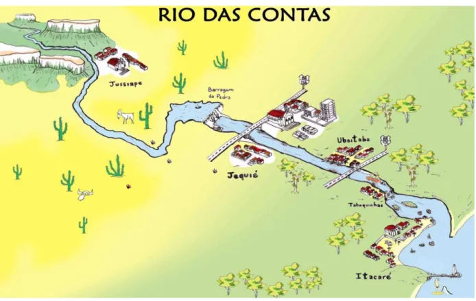
entire course of a river in Bahia, which lows from a mountain range of the Chapada Diamantina, in the municipality of Piatã (from there) and lows into the Atlantic Ocean in Itacaré (to here), a
city in southern Brazil (Figure 1).
Figure 1 - Pictorial-poetic image of the Das Contas River, Bahia. Source: Chiapetti (2009, p. 72). From Bruno Harry Ceccato
It is important to emphasize that our reading of the image cannot be taken as an absolute truth
because just like a written text it may have insuiciencies and limitations, since it is made from our
perception and cognition. When this image was elaborated, its main purpose was to represent the Das Contas River within the Atlantic Forest, the main focus of our research at that time, so perhaps
it has more details in its inal section: “In the beauty of the place, Das Contas River going... to the
sea” (CHIAPETTI, 2009).
But why are we calling this pictorial drawing a poetic image? Because when we asked Bruno to create it, we showed him some images of the Das Contas River and we described it from the source to the mouth, talking about it as if it were a person, a friend, so great has been our intimacy
with this river, since we decided to study it. Like Gratão (2002, 2007a), we ind ourselves with the river, we feel a water geography that is born of the deep afective bond with it: hydric topophilia
or hydrophilia!
So Bruno imagined the river materially and poetically and created this drawing/image, as if
he were navigating its waters... experiencing every bank, every landscape, every moment, every
curve of the river. His imaginary was seduced by our imagination, which led his hand to draw the river and its banks bathed in life all along its route! After all, according to Bachelard (2005, p. 2): “The poetic image emerges in consciousness as a direct product of the heart, the soul, the being of man taken in its totality”. However, it also has matter. Water is matter and imagination, it wraps dreams, and it is a source of poetic inspiration, as manifest in human images and symbols and in
their actions (GRATÃO, 2007b).
to
r.
u
fc.
b
r
and soul). We imagine that it is diicult to give a sense of understanding and to be able to commu
-nicate one’s vision, so as to interpret what a humanist geographer thinks, charmed by the object of
study. In this sense, we can airm that the architect-artist’s gaze took place through the “eyes of
the mind” because it came from his perception and imagination in relation to the images we gave him, from the aspects of the landscapes of these images, seeking the elements that represent them. The imagination surpasses reality, it sees the invisible, it goes to the bottom of things... the image can only be captured in the measure that it has its entire being in the imagination (CHIAPETTI;
GRATÃO, 2010).
Now, if an image is the result of the eye of the person who creates it, imagines it and its mea-ning is a consequence of the interpretation given by the viewer, observer or the spectator, then the pictorial-poetic image of the Das Contas River is a result of our way of looking at the river and according to Ferraz (2009), it is this look of the observer/creator that interests [Humanist]
Geo-graphy. On the humanist perspective of Geography, Chiapetti and Gratão (2010) write that it is a
science that has the possibility of meeting with art, through its categories of analysis, contained
in their poetry or in any type of artistic representation, such as an image, for example. These are “new” (or not so new) ways of understanding space and interpreting the culture expressed through
language and/or image, created by authors and artists. A humanist geographer must, among other things, awaken our awareness that we are responsible for our geographic space and that we must
relect critically on it, by diferent means (art may be one of them). Therefore, in this text we carried
out, with sensitivity and knowledge of reality, the analysis and interpretation of the image (in this case, pictorial or artistic) that represents the Das Contas River and its phenomena, with human life represented in its landscape.
An image can represent what we perceive, know, feel, yearn, imagine, dream, live, experience, think, write, discuss... Reading and analyzing an artistic image can be a way of aesthetically relecting
on that place, that landscape (world view), because we can read and interpret this image and, from
it, get information, knowledge about the place, about the world. But, like all non-verbal texts, it
allows several interpretations of its signs or drawings; it is the way we grasp its meanings that will reveal our reading of the image. Between the image and the reality that it represents there are many factors that can guide our reading, so everything depends on our knowledge of reality, the cultural conditions, perception, imagination, feelings... for the image to be a true reconstruction of reality. The understanding of the aesthetics and poetics of the pictorial-poetic image of the Das
Con-tas River leads us to a relection on the course of the river, on its river basin, from our knowledge of the reality of the river. Of course, in addition to geographic knowledge, sensitivity is needed to understand the context in which this image was created. Thus, the artistic and sensitive aesthetic
interpretation of this image reveals our emotions regarding the river. Its reading and analysis are
ways of understanding the river and its real banks and aesthetically ofering information as if it were a language, that is, a visual or non-verbal text.
This pictorial-poetic image illuminates our words, giving them poetic sense, as it also adorns our “river-friend.” We give ourselves the right to call it that, since in the time in which we have
researched and experienced it, we have come to know it beyond its physical form, knowing its es
-sence. This is how the Das Contas River presents itself in this image/language. Our intention in this text is not to conceptually analyze the pictorial-poetic image within the notions of semiotics, but
rather to improve our geographic reading of the river, poetically, as Ferraz (2009) writes, through aesthetic and sign analysis, toward an interpretation of the landscape from its pictorial representation.
This pictorial drawing of the Das Contas River is a ixed image, stopped in time but able to
represent its landscapes. The main forms of occupation of the banks of the river are represented by
igures or symbols expressing ideas, that is, the igurative and stylized drawing (a igure for each object) functions as a sign (symbol) of writing. It is as if a text on the Das Contas River was written
w
w
w
.me
rca
to
(2000), photography is a subjective, emotional look that interprets cuts, selects and chooses; but also, it is the look of the enthusiast, with their culture, emotion and life history. Photography is still
an indirect text, in which one can hide, beyond the image, in the imaginary.
When we look at the image, the Das Contas River emerges as if it were born in the background (in the west), in the mountains of the Chapada Diamantina, distant in the image, another landscape and winding with the movement (energy) of its waters, it symbolizes the life on its banks, until reaching its destination, in the foreground of the image (in the east), when it ends in the sea, in front of the city of Itacaré, on the south coast of Bahia. Also we can imagine a river that rises on the top of the mountain (1,500 m of altitude), descends... symbolically telling all the adventures of life in the sertão… and enters the forest to meet the sea. In this way, the river serves as a representation of human life wherever it passes, since its water kills thirst and hunger, washes, leads, produces energy, entertains... it is human survival itself!
In this pictorial-poetic image we are poetizing the Das Contas River. To poetize is to say what could not be said otherwise, it is to seek words in silence; it is to draw from its image and landscape the inspiration to compose a song, write a poem, make a drawing, a painting or simply art, besides imagining, dreaming, daydreaming or thinking about reality. We agree with Bosi (2006, p. 75):
“The truth of art is a truth of body and soul” and therefore any artistic expression can be a direct way to reach people’s understanding of what we want to express because it is a universal language,
which can be understood by diferent cultures, promoting dialogue, relection, an encounter betwe
-en them. To poetize is also to delight in this image of the Das Contas River, which creates a kind of poetic narrative about it, represented in the blue of the water and in the shades of colors of its banks between (the Brazilian) green and yellow, going from the green of the mountains, through the semi-arid yellow sertão and gradually, in a transition area, becoming greenish yellow, until it reaches the green Atlantic Forest.
Furthermore, we can interpret this pictorial-poetic image, relecting on the river that is born
in a “green oasis” within the “yellow sertão of Bahia”, contributing to the living conditions of the Chapada Diamantina’s population (tourist activity in the mountains and agriculture on the valley
loors). Then, in the “yellow Caatinga”, it continues donating life to agriculture, goat breeding and
electric energy production, to return to being “green in the Atlantic Forest”, its most populous
stre-tch, afectionately known as the Cocoa Region of Bahia (a region that still produces cocoa, a great wealth of Brazil), and inally to empty into the calm Concha beach, in the city of Itacaré, heavily
frequented by Brazilian and foreign tourists.
The colors are very important in this poetic of the river, they are like elements that sustain the
landscape, contrasting with the blue of the water, which seems to low through by the image and
in reality producing electric energy (Pedras Hydroelectric Plant, in Jequié), connecting the three biomes, crossing two large Brazilian highways (BR 116 and BR 101), linking cities in Bahia (Ju-ciape - Jequié - Ubaitaba - Itacaré), passing through Taboquinhas district (municipality of Itacaré),
when the river narrows into a canyon and inally meeting the sea, or turning into the sea!
The symbolic value of the colors represented in the pictorial-poetic image goes through the life of the river itself, born in the touristic Chapada Diamantina, from beautiful landscapes, surviving in
the long-sufering Caatinga of the sertão, of the Mandacaru cactus and the goat, but also produces beautiful landscapes (depending on the eye), experiencing the coastal tourism of Bahia, of green forests, crystalline rivers and wonderful beaches. We can airm, according to Gratão (2007a, p.
103): “It is ‘The river’ perceived through the look, by the senses, sensations, in what is ‘visible’ in the ‘not visible’; in the shift...in movement ... in color... in the smell... in sounds & tones... ‘The river’ evoking feelings, emotions, memories, evoking the Spirit of the place...”.
to
r.
u
fc.
b
r
THE RIVER ... DRAWING ITS LANDSCAPES
The geographic landscape is not, in its essence, only to be contemplated, but refers to the in-sertion of people in the world, a place of life, a manifestation of their being with others, the basis of their social being (CHIAPETTI, 2009). Therefore, landscapes presuppose the presence of
peo-ple, even when they are physically absent, because they express their fulillment and existence on Earth. Thus, we can airm that the landscapes of the Das Contas River represent the experiences
of the people who have passed through, inhabited and inhabit its river basin. They are, therefore, lived landscapes, in which the relations of people with their place are evident, being substrates
of their experiences in the river. For Besse (2006), the landscape is the expression of existence,
being a bearer of meaning, because it represents the encounter between the Earth and society. It is essentially more of a human world than natural. It is culture as the meeting of human freedom with its place, the Earth.
The landscape is the representation of what we see, however, vision is only the sensation of what we perceive, evidence of the invisible. Thus, when trying to represent what we perceive and which is often invisible, we use symbols. Therefore, a landscape can be symbolic, representing
the expression of the multiple senses that we confer to our environment. Yázigi (2001) also writes about the symbolism of landscapes, saying that they have expressively symbolic attributes, which
leads us to consider that the natural beauties of the Das Contas River are some of its symbols and therefore represent some of their landscapes.
The landscapes of the Das Contas River are the result of historical processes, representing
diferent moments of the societies that inhabited its river basin. It is as if it were pouring into its
banks the landscapes that have been transported in its waters since time immemorial, becoming a
memory of the history of Bahia and, perhaps, of Brazil. As an example, in the Chapada Diamantina its landscape has marks of the gold and diamond exploration of the past and in the Atlantic Forest
the landscapes are of cacao farms, which historically keep producing in the same way. The beautiful
and diicult reality that moves and shelters on the banks of the Das Contas River presents itself,
not merely as landscapes represented in a pictorial-poetic image, but as an inseparable part of the whole, which constitutes the essence of its river basin, human sensitivity (or not), the mysteries of life, in short, the lives of the people who inhabited and still inhabit the banks of this river, building their landscape and their identity. For Gratão (2002) these are landscapes described and internalized
in feelings, registering intimacies and guarding perceptions and signiicant experiences.
The landscapes keep the intentions and actions of the people in the places, because they are
marks imprinted on the original landscapes and events are recorded over time, considering diferent
natural and cultural factors. Therefore, landscapes are the result of a succession of intricate supe-rimposed factors, which are registered in the individual and collective memory of society, becoming
powerful elements of cultural identiication, which are constantly being updated.
So, in order to analyze a landscape or, in this case, the landscapes drawn along the Das Con-tas River, in addition to the natural and human elements it is necessary to understand the meaning of this river in Bahia’s history and the history of the river itself, geared towards the people who
produced/constructed/experienced its landscapes. These landscapes were experienced by native people, slaves, miners, European explorers, Portuguese settlers, foreign pirates-thieves, sugar cane
planters, inhabitants of the villages and after the small towns that formed along the banks, cacao
growers, ferrymen, boatmen, ishermen, seafood ishers, laundrywomen, escaped slaves, tourist guides, rafting instructors, tourists, athletes, poets, thinkers... landscapes experienced by people
who have built and continue to build the identity of the river.
w
w
w
.me
rca
to
Inácio Hill (the largest in the image), besides being aesthetically beautiful, there are no words to explain the sensation we feel when we are up there. Perhaps the feeling of belonging to nature,
being nature itself, or perhaps being so small near such greatness! The Tromba mountain range (the river’s source), on the west side of the Chapada Diamantina, is considered to be one of the most preserved in the state of Bahia. The whole drainage network of this mountain enters the Das Contas
River, which is born in the extreme south of the municipality of Piatã.
The landscape of the Chapada Diamantina can be geomorphologically identiied, according to
Brasil (1981) as an old and worn relief, with mountains, dissected plateaus that stand out, carved by water and wind, cut by deep valleys of rivers. This landscape was formed thanks to millions of years of erosion because as some sedimentary rocks are more compact and others more permeable,
that is, easier to be iniltrated by water, with the passage of time some resisted, others were more worn down. Sandstone, for example, is more resistant to water action and has resisted in the higher altitudes. The cracks in the rocks facilitated the iniltration of water, and thus, the less resistant ones
were eroded, with the aid of climatic variations.
According to the Brazilian Institute of Geography and Statistics (IBGE, 1960), the Chapada Diamantina area (like the entire northeastern sertão) was subject to a series of diverse morphocli-matic systems. Initially, there was a wet period when the valleys were carved out and the inversion of the relief began. Subsequently, the climate became drier, the granitic rocks were removed more quickly and the sandstones and limestones became more prominent. Due to the dry climate, the
inter-mountain plains and sediments of ine limestone, known as calcareous Caatinga, were exten
-ded. These sediments are evidence that the area was subject to alternating climates.
When the weather became more humid, the rivers began to carve their beds in the limestone. However, when another dry phase began, they started to be clogged again by deposits brought about by the action of rainwater. This climatic alternation occurred in the Pleistocene and
Holo-cene geological periods (IBGE, 1960). The climatic oscillations of the PleistoHolo-cene afected all the
old surfaces, introducing alterations in the evolution of the slopes, so that it is possible to glimpse
several morphoclimatic systems in the Chapada Diamantina. In order to explain the evolution of
the Chapada Diamantina’s landscape we must understand that its formation took place in distinct processes and occurred in times geologically very far apart (BRASIL, 1981).
In relation to the human occupation of its river basin Jorge (2006), when writing that the Das Contas River, with its tributaries, amid hills, sertão, forests and mangrove swamps, gave Bahia’s lands a truly charming aspect, with an environment conducive to the establishment of human
set-tlements, as the physical conditions, lora, fauna and water provided people with an opportunity
for subsistence. Like many other rivers, the Das Contas River certainly had great importance in the beginning of the towns that gave origin to the cities located along its route. It was from this
that the exploration of gold advanced in the sertão of Bahia, settlements emerging and roads being
built in the region nowadays occupied by the Chapada Diamantina (TEIXEIRA, LINSKER, 2005). In the pictorial-poetic image of the river, Jussiape is the city that represents the urban landscape
in the Chapada Diamantina area, a municipality with intense tourist activity. Oicially, the muni
-cipality of Jussiape is included in the gold circuit, possessing a historical landscape preserved by folk customs and traditions, as well as the beauties of the landscapes, such as the Serra da Itobira
and the former gold mines of Pedro Silva and Beta da Tavinha. There are also signiicant archaeo
-logical sites, such as the unpublished pictorial representations of the Serra da Tapera and the cave paintings of Espinho (http://www.bahiaemfoco.com/jussiape).
to
r.
u
fc.
b
r
metamorphized rocks or areas of crystalline shells, which are characterized by being subjected to
intense removal and where morphoclimatic inluences predominate on these structures.
For Conti (2002), the landscape from the semi-arid climate, with its lithological and geo-morphological characteristics, is very particular, mainly due to the presence of the vast Caatinga,
formed by dry shrubs, cacti, bromeliáceas and trees of rare beauty, like the umbuzeiro (Spondias
tuberosa). The cactus named Mandacaru, is an important symbol of Bahia’s sertão and was there-fore represented in the pictorial-poetic image of the river, in addition to goat breeding, which also
composes its poetic landscape (pastures for breeding goats - the largest lock - predominate in the
Caatinga). The symbolic content of the landscapes can be used to create touristic images, which, in the case of Bahia’s sertão are very well represented by these elements or symbols, that is, cacti and goat breeding.
Within this domain the Das Contas River, does not have a large volume of water, due to the rigors of the semi-arid climate, with an absence of rain for most of the year and with water loss by evaporation. Another factor that contributes to the dry landscape of the river is that in the
munici-pality of Jequié it was dammed to control loods, supply water, agricultural irrigation and electric power generation, according to the São Francisco Hydroelectric Company (CHESF). It now lows slower in a large lake (approximately 70 km long and 38,700 km2), gaining strength and power to
generate the turbines of the Pedras Hydroelectric Plant, since 1969 (www.chesf.gov.br). After this intervention in the river’s course, its waters were controlled by people, who have power over the life of the river (releasing more or less water in the spillways of the great lake) and only then can
it become once more a humble river lowing downstream... in search of its bed. It is important to
remember that even with all the controversy about the installation of a hydroelectric power plant, the
Pedras dam’s lake in Jequié enchants many people, who use it for fun, ishing, sports, inspiration,
contemplation... another landscape!
Like the Chapada Diamantina, the Das Contas River played an important role in the human occupation of Bahia’s sertão. In the relation that the sertanejo establishes with the river, there is
an entire relationship of the exchange of survival between them and the river itself, in the way of feeling it, using it and experiencing it. As an example Jequié, the largest municipality on its banks,
is considered to be the mouth of the sertão, because it is located in the transition area between the sertão and the forest. As it was formerly more voluminous and narrow and therefore navigable, the Das Contas River was the main transportation route for the products necessary for the subsistence of the local inhabitants, such as: cereals, vegetables, fruits, greens and some industrialized products. Thus, Jequié developed from a lively market (a tradition of northeastern culture) that attracted people and merchants from all over the region.
Finally, to end our trip through the waters of the Das Contas River, the landscape of the Atlantic Forest comprises the South-Baiano, Pre-Coastal and Coastal Plateaus. These plateaus
cover mountainous reliefs with mountainous features, interspersed with relatively lat areas, with
decreasing altitudes to the coast (BRASIL, 1981). According to Brasil (1981), within this biome, in the vicinity of the river mouth, in the geomorphological domain of the Coastal Plain, there are
Marine and Fluvial-marine Plains, which have marine, luvial, colluvial and eolic origins that
translate the stages of evolution of the coast and the lower courses of the rivers. Along much of its
extension in this landscape the Das Contas River is bordered by the remnants of the Atlantic Forest
in its secondary phase, which follows the gliding of the river, sometimes slow or fast in the rapids of the district of Taboquinhas (Itacaré municipality). The trees in this area are large and harbor a rich and diverse fauna.
On its journey through the forest, the Das Contas River is dammed again for its waters to
move the turbines of the Funil Hydroelectric Plant (operating since 1962), in the municipality of Ubaitaba, in the south of Bahia. The walls of this dam imprison it, again, forming a small lake of
w
w
w
.me
rca
to
who sufer the loss of the river and the Funil waterfall, which was submerged with the construction
of the reservoir. For Ferreira (2001, p. 100): “At that time, only the region’s progress was taken into account and environmental protection was forgotten. The plant was built and given the name of ‘Funnel Hydroelectric Plant’, after the waterfall. It is just as well they remembered this tribute!” Thus, future generations will know that there is a beautiful waterfall submerged in the waters of
the Funil dam. This same author explains that the waterfall was formed by three large stones that
together resulted in a huge crater in the form of a funnel; hence the origin of its name. When the Das Contas River had little water, the stream passed under the stones, giving the impression that
the waters disappeared into the earth, only to low into the sea, much later.
In the Atlantic Forest area of southern Bahia, the Das Contas River was one of the great mo-tives for the beginning of settlement, being the shelter/home of the native people who inhabited the region before the arrival of the Europeans and the waterway of the Portuguese in search of the interior of the Continent, as well as a refuge for fugitive slaves. In this section, the Das Contas Ri-ver represents a link between the cities of Jequié, Jitaúna, Ipiaú, Barra do Rocha, Ubatã, Aurelino Leal, Ubaitaba and Itacaré, since all are blessed with its water, but they are also responsible for life of the river, for its landscapes. Everything that is done in one city comes to the other... it is water connecting lives. But unfortunately, in this region the river shows signs of pollution due to the waste dumped in its waters by the population of these cities, even though the Superintendence of Water Resources of Bahia (SRH/BA) does not prove this fact, because, according to this state body, the river is only polluted in the vicinity of the city of Jequié, in the transition from the Caatinga to the Atlantic Forest.
On the river lowing and full in this landscape there is only longing, like that of the poet Fuad
Maron, who with sensitivity and beauty sings, in his poem, the Das Contas River of Ipiaú.
Das Contas River, root of my longing
When the sunlight seeps The dark sky appears Then the water descends,
Fills the river, and the heron lies ...
While rowing, the canoe dances, The hopeful boatmen
Cast their nets in the water,
While it lows out
The river runs, narrows and passes Foaming past the huts
Under a beautiful indigo sky Racing through the funnel And then galloping to the sea.
From Jequié is lows full
The river kissed the sunset
Relected on the lush
Today cut in half ...
to
r.
u
fc.
b
r
Nothing else moves in it
There are no ferries and canoes! ...
The Kingisher no longer lies
The long-tailed tyrants and herons have left...
The Water Rail in other places
Oh! My river, I missed you for nothing.
Far away today, I reap an aurora.
The Das Contas River at six o’clock
Receives a kiss from the breeze Singing birds are heard
Warbling on your banks
When the sun extinguishes its skirt
At night which garland is seen In the white silver moonlight, And the coconut palm fronds Are vigilant warriors
Where the isherman is hiding
And in other trees with fronds And in the tawny sandbanks.
Das Contas River from my city
Your sands are so white.
You are the root of my longing, You run in my veins.
Source: Maron (1997).
On the other hand, in Itacaré, the last municipality that it bathes the Das Contas River ofers its
waters and landscapes to tourism, which is the means of survival for a large part of the population, corroborating Gratão (2007b), for whom throughout the world water has attracted tourism, more and more desired and sought after - adventure, cultural and religious tourism. It is the presence of the turbulent and calm water of the river, the mountains, the Atlantic Forest (still with conserved areas) and also the local characteristics of the sea that become attractive for regional, national and international tourism. In the course of the Atlantic Rainforest within the territory of Itacaré, the landscapes of the Das Contas River are marked mainly by adventure tourism in its waters, as it winds snake capriciously through ravines, forming rapids (stretches of rivers, where the waters are faster), a canyon (narrower river) and the last waterfalls from its bed, the waterfalls of Fumo and Pé da Pancada, in the district of Taboquinhas.
w
w
w
.me
rca
to
river, until it reached the sea. It is one of the river’s landscapes, a landscape humanly registered in its waters and in the memory of the people of Taboquinhas! It is incredible how we imagine this
landscape experienced by the people of the river, when we know the village of Taboquinhas and its
history! In fact, there is still the stone road that carried the carts loaded with cacao to its right bank.
Another landscape of the Das Contas River, within the Atlantic Forest, is the practice of extre
-me sports, mainly by tourists. The waters agitated by rapids (they serve as paths for the practice of sports) and the narrow banks of the canyon are conducive to rafting (represented in the image by a boat carrying people by the waters of the river, in Taboquinhas). This is a type of sport practiced in
rapids and small river waterfalls using inlatable boats and oars, in which the practitioners must use
helmets and life jackets. Rafting is a symbol of the river’s landscape in the district of Taboquinhas,
since it is a tourist landscape greatly promoted by the regional media and experienced by domestic
and foreign tourists.
Also in its last stretch, the Das Contas River lives and at the same time is the location of the beautiful landscape of speed canoeing, a sport practiced mainly in the riverside cities of Ubaitaba (called Bahia’s canoeing capital) and Itacaré. This sport impresses by the beauty of the canoes skimming gently through the water... as if the canoeists were gliding over the river... competing with the speed of the water or mingling with it!
The river, in its heroic adventure through Bahia, inally inds its destination, with the certain
-ty of a du-ty fulilled, that is, to carry water in its river bed, mixing it with the sea of the immense Atlantic Ocean! The last landscapes of the river are recorded in its estuary and in its pictorial-poetic image: ishing boats arriving from work at sea, canoes or boats for touring the waters of the river,
the urban tourist life of Itacaré, Concha beach and the Barra Lighthouse, which daily witness the encounter of the river with the sea, when the river turns to sea.
Before inishing this text, besides the essence of the river, we would like to write about its
agony, that is to say, about the death of the Das Contas River in the stretches in which some cities, mainly Jequié and some on the lower river, in its most populous stretch in the Atlantic Forest. Even if this is not drawn in its pictorial-poetic image, the real landscape represents the sad image of reality and does not hide this sadness! These are the waters of the Das Contas River in the south of Bahia, traversing many cities and carrying the pollution poured into its bed, without blame for those who do so.
We need rivers so much and why do we mistreat them so badly?! Are not we dying along with our rivers?! If water commands the earth, it commands life, it is the life of the earth, how can we mistreat it, polluting it? What will the fate of the Das Contas River in a while? We have no answers
to these questions but with this text we want people to relect...
We ask, then, does the Das Contas River still exist? The jequieense poet Daniel Gomes de
Souza Júnior, in his poem “There is a river”, writes about the importance of this river in the past,
a river that today is abandoned and with an uncertain existence in the future.
There is a river
There is a river that in the past has been explored, sucked dry.
Today there is an abandoned river,
Dirty, almost inished.
The past remembers the river with longing; This river that crosses several cities
to
r.
u
fc.
b
r
People who look at the river without afection,
Without looking at the concrete... the river and its uncertain future. Without knowing if one day... we can call the poem: there is a river or There was a river
Source: www.webartigos.com/articles/22272/1/RIO-DE-CONTAS/pagina1. html#ixzz1KjCJ91z8.
The social death of the river, as the anthropologist Leonel (1998) writes about the relations of society with nature, which are inseparable from the relationships that men maintain among them-selves. Regarding the relationship we have built with the Earth, Gratão (2007a) invites us to change our thinking and attitude, since we have become the owners of natural resources, not respecting our natural and cultural ties with the Earth. A new way of looking at the world starts from fundamental
changes in our thoughts, perceptions, attitudes and values. We must relect!
FINAL CONSIDERATION
Relection... we hope that we have succeeded in providing a geographic-humanist relection
in this text, a poetic essay, conducted by the waters of the Das Contas River, through its pictorial
--poetic image, representing the landscapes lived by the people of its river basin and described by
our perception. We refer to a geographic-humanist relection because we place human beings as the object of scientiic knowledge, since the landscapes are constructed and lived by them.
Through phenomenology, a theoretical-methodological proposal that led to our analysis, it was possible to interpret, describe and understand, with great sensitivity, the course of the Das
Contas River from there to here ... drawing its landscapes, empowered by our experience and ge
-ographical knowledge. Phenomenological research starts from the understanding of living and not
from deinitions or concepts, being an understanding directed at the meanings of perceiving, which
shows itself and in itself as it is. Thus, this focus, approach or methodological attitude, considered by many to be unusual, proved to be valid in our work, considering that we could understand what was manifested, what was actually shown in the landscapes constructed by the people of the river. The pictorial-poetic image had the role of representing in an artistic and aesthetic way our emo-tions in relation to the Das Contas River, since art is a way of manifesting / living the poetic quality
of life. Thus, signs, symbols or igures represented our perception or geographical interpretation of
reality and also how we perceive the meanings of the landscapes that were pictorially represented, or rather, how we poetically portrayed our knowledge of the geographic reality of the river.
Finally, our main objective was reached, since we intended, with the elaboration of this po-etic essay on the Das Contas River, to make a geographical reading towards the interpretation and analysis of its landscape, from its pictorial representation. All the landscapes drawn by the river in the image and registered in its waters and margins are real demonstrations of the people’s connection
with “their river”, of the experience of the being in the world, their lived space. The river, along its
path (green, yellow and green again), carries the landscapes of the touristic Chapada Diamantina, of the distant sertão of Bahia, the green Atlantic Forest and the beautiful southern coast of Bahia,
recording the experiences, intentions and actions of people in the river-place. The pictorial-poetic
w
w
w
.me
rca
to
BIBLIOGRAPHIC REFERENCES
BACHELARD, Gaston. A água e os sonhos: ensaios sobre a imaginação da matéria. São Paulo: Martins Fontes, 2002. 202 p.
BACHELARD, Gaston. A poética do espaço. São Paulo: Martins Fontes, 2005. 242 p.
BESSE, Jean-Marc. Ver a terra: seis ensaios sobre a paisagem e a geograia. São Paulo: Perspectiva, 2006. 108 p.
BOSI, Alfredo. Fenomenologia do olhar. In: NOVAES, Adauto (Org.) et al. O olhar. São Paulo: Companhia
das Letras, 2006. p. 65- 87. 495 p.
BRASIL, Ministério das Minas e Energia, Secretaria Geral. Projeto RADAMBRASIL. Folha SD 24 Sal-vador: geologia, geomorfologia, pedologia, vegetação e uso potencial da terra. Rio de Janeiro, 1981. CHEVALIER, Jean; GHEERBRANT, Alain. Dicionário de símbolos: mitos, sonhos, costumes, gestos,
formas, iguras, cores, números. Colaboração de André Barbault et al. e coordenação de Carlos Sussekind. 21. ed. Tradução de Vera da Costa e Silva et al. Rio de Janeiro: José Olympio, 2007. 996 p.
CHIAPETTI, Rita Jaqueline Nogueira. Na beleza do lugar, o rio das contas indo... ao mar. 2009. 216 f.
Tese (Doutorado em Geograia) - Instituto de Geociências e Ciências Exatas, Universidade Estadual Paulista
Júlio de Mesquita Filho, UNESP, Rio Claro, São Paulo, 2009.
CHIAPETTI, Rita Jaqueline Nogueira; GRATÃO, Lúcia Helena Batista. A poética n’as curvas do rio: a
imaginação geográica no rio Cachoeira. Geograia, Rio Claro, v. 35, n. 2, p. 275-289, maio/ago. 2010.
CONTI, José Bueno. A natureza nos caminhos do turismo. In: RODRIGUES, Adyr Balastreri (Org.). Turismo e ambiente: relexões e propostas. 3. ed. São Paulo: Hucitec, 2002. 177 p. p. 17-26.
DARDEL, Eric. O homem e a Terra: natureza da realidade geográica. São Paulo: Perspectiva, 2011. 159 p.
FERRAZ, Claudio Benito Oliveira. Geograia: o olhar e a imagem pictórica. Pro-Posições, Campinas, v.
20, n. 3, p. 29-41, set./dez. 2009.
FERREIRA, Ivan Estevam. Ponte do Cristal. Vitória da Conquista, BA: Edições UESB, 2001. 224 p.
GRATÃO, Lúcia Helena Batista. A poética d’ “O rio” – ARAGUAIA! De cheias... &... vazantes... (à) luz da imaginação! 2002. 354 f. Tese (Doutorado em Geograia Física) - FFLCH, Universidade de São Paulo,
USP, São Paulo, 2002.
GRATÃO, Lúcia Helena Batista. (À) Luz da imaginação! “O Rio” se revela na voz dos personagens do
lugar-ARAGUAIA! Caderno de Geograia, Belo Horizonte, v. 17, n. 28, p. 89-120, 1º sem. 2007a.
GRATÃO, Lúcia Helena Batista. A água no luxo do turismo - do elemento essencial ao destino do turista...
convite ao lazer, prazer, ócio, hierofonia, sonhos e imaginação! In: SEABRA, Giovanni. Turismo de base local: identidade cultural e desenvolvimento regional. João Pessoa: Editora Universitária da UFPB, 2007b.
356 p. p. 51-64.
HOLZER, Werther. Uma discussão fenomenológica sobre os conceitos de paisagem e lugar, território e meio
ambiente. Revista Território, Rio de Janeiro, n. 3, p. 77-85, jul./dez. 1997.
IBGE. Instituto Brasileiro de Geograia e Estatística. Enciclopédia dos municípios brasileiros. Rio de
Janeiro: IBGE, 1960. Vol. V.
JORGE, Janes. Tietê, o rio que a cidade perdeu: o Tietê em São Paulo – 1890 a 1940. São Paulo: Alameda,
2006. 232 p.
LEONEL, Mauro. A morte social dos rios. São Paulo: Perspectiva; Instituto de Antropologia e Meio
Am-biente; FAPESB, 1998. 263 p. (Coleção Estudos, 157).
LESSA, Gabriela. No baixo São Francisco, a viagem do redescobrimento: do espaço ao lugar. Niterói, RJ,
2007. 167 f. Dissertação (Mestrado em Arquitetura e Urbanismo) – Universidade Federal Fluminense, UFF, Niterói, RJ, 2007.
MARON, Fuad. Os canoeiros do rio das Contas. Salvador: Graicartes, 1997. 117 p.
to
r.
u
fc.
b
r
OLIVEIRA, Lívia de. Sertão rosiano: percepção, cognição e afetividade geográica. Scripta, Belo Horizonte,
v. 5, n. 10, p. 234-242, 1º sem. 2002.
PINHEIRO, Jane. Antropologia, arte, fotograia: diálogos interconexos. Cadernos de Antropologia e
Ima-gem, Rio de Janeiro, UERJ, v. 10, n. 1, p. 125-35, 2000.
SEI. Superintendência de Estudos Econômicos e Sociais da Bahia. 1994. Disponível em: <http://www.sei. ba.gov.br/>. Acesso em: maio 2013.
TEIXEIRA, Wilson; LINSKER, Roberto (Coords.). Chapada Diamantina: águas no sertão. São Paulo: Terra Virgem, 2005. 160 p.
YÁZIGI, Eduardo. A alma do lugar: turismo, planejamento e o cotidiano em litorais e montanhas. São