Repositório ISCTE-IUL
Deposited in Repositório ISCTE-IUL: 2019-04-12Deposited version: Post-print
Peer-review status of attached file: Peer-reviewed
Citation for published item:
Afonso, L., Souto, N., Sebastião, P., Ribeiro, M., Tavares, T. & Marinheiro, R. (2016). Cellular for the skies: exploiting mobile network infrastructure for low altitude air-to-ground communications. IEEE Aerospace and Electronic Systems Magazine. 31 (8), 4-11
Further information on publisher's website: 10.1109/MAES.2016.150170
Publisher's copyright statement:
This is the peer reviewed version of the following article: Afonso, L., Souto, N., Sebastião, P., Ribeiro, M., Tavares, T. & Marinheiro, R. (2016). Cellular for the skies: exploiting mobile network
infrastructure for low altitude air-to-ground communications. IEEE Aerospace and Electronic Systems Magazine. 31 (8), 4-11, which has been published in final form at
https://dx.doi.org/10.1109/MAES.2016.150170. This article may be used for non-commercial purposes in accordance with the Publisher's Terms and Conditions for self-archiving.
Use policy
Creative Commons CC BY 4.0
The full-text may be used and/or reproduced, and given to third parties in any format or medium, without prior permission or charge, for personal research or study, educational, or not-for-profit purposes provided that:
• a full bibliographic reference is made to the original source • a link is made to the metadata record in the Repository • the full-text is not changed in any way
The full-text must not be sold in any format or medium without the formal permission of the copyright holders.
Serviços de Informação e Documentação, Instituto Universitário de Lisboa (ISCTE-IUL) Av. das Forças Armadas, Edifício II, 1649-026 Lisboa Portugal
Phone: +(351) 217 903 024 | e-mail: [email protected] https://repositorio.iscte-iul.pt
L. Afonso, N. Souto, P. Sebastião, M. Ribeiro, T. Tavares and R. Marinheiro are with the ISCTE-University Institute of Lisbon, and with the Instituto de Telecomunicações, Portugal ([email protected], [email protected], [email protected], [email protected], [email protected], [email protected]).
Cellular for the Skies: Exploiting Mobile
Network Infrastructure for Low Altitude
Air-to-Ground Communications
Luís Afonso, Nuno Souto, Pedro Sebastião, Marco Ribeiro, Tiago Tavares, Rui Marinheiro
ABSTRACT
In the last few years, unmanned aerial vehicles (UAVs) have been standing out as a pervasive tool in numerous civil and commercial applications. Although different wireless technologies can be employed to establish communications between a UAV and a ground control station (GCS), most either limit the operational radius or increase substantially the complexity of the system. Taking into account insights from our own real-world experiments and studies carried out within the scope of the SAAS project from Instituto de Telecomunicações, in this article we discuss the use of mobile networks for low altitude air-to-ground (A2G) communications as a possible solution to provide extended mobility and range to operators and UAVs. Besides addressing the advantages and the associated constraints of using these networks, we propose a flexible architecture for multiple UAVs and GCSs. Although our experimental results have shown that current mobile networks can fulfil the basic requirements for many envisioned UAV applications, we discuss how the evolution towards 5G networks is expected to improve the support for reliable real-time A2G communications and even for air-to-air communications.
I. INTRODUCTION
Although the concept was born within military use, in recent years we have witnessed an impressive development of unmanned aerial vehicles (UAVs) for civil and academic applications. Driving this growth is the myriad of possible scenarios where this technology can be deployed, such as: fire detection, search and rescue operations, surveillance, police operations, building and engineering inspections, aerial photography and video for post-disaster assessment, agricultural monitoring, remote detection (radiation, chemical, electromagnetic), weather services, UAV photogrammetry, airborne relay networks, and more [1]. Undoubtedly, the increased use of UAVs has been sustained through the research and development of multiple low cost solutions for the control of aerial vehicles, the evolution in microelectronics with multiple off-the-shelf components and sensors and also through a growing global developers community with several UAV related open source projects.
The safe operation of a UAV requires a communication link to deliver telemetry data, control commands and other information between the vehicle and a ground control station (GCS). Different solutions have been studied and implemented, as discussed in [2], but most suffer from either a restricted operational range or a high implementation complexity. A potential alternative to overcome the range limitation with reduced complexity, which has not been adequately studied so far is to use existing wide coverage mobile radio infrastructures, such as GPRS/EDGE, UMTS, HSPA+, LTE and LTE-A. In this article, we discuss the viability of this approach. Based on our own experimental studies, performed within the scope of the Portuguese Remotely Piloted Semi-Autonomous Aerial Surveillance System Using Terrestrial Wireless Networks (SAAS) research project, we will focus on the advantages of using cellular networks as well as on the problems that can arise and possible solutions to deal with them. We present a flexible architecture for a multi-UAV, multi-operator system which can make use of third and fourth generation (3G/4G) wireless networks and describe some results obtained from experimental tests using our
unmanned aerial system (UAS) implementation. Finally we comment on potential improvements that can be expected from future cellular networks in this context.
II. UNMANNED AERIAL SYSTEMS
In general, a UAS consists of the vehicle, known as UAV, and the mechanisms, logistic and equipment regarding its proper operation. UAVs can be grouped into different categories according to their size [3], with the micro aerial vehicle (MAV), which typically weighs less than 2 kg and operates at low altitudes, being the most appellative for civil use. Several companies and academic groups have developed proprietary and open source hardware/firmware/software for UASs. The hardware includes the vehicle, flight avionics (which includes the flight controller) and the wireless communication subsystem. The firmware running on the flight controller is responsible for the stabilization of the vehicle, geolocation and preprogramed waypoint navigation. Additional software is often provided for implementation of GCS functions namely, mission planning, monitoring and control. A ground operator can use the GCS application to communicate with the flight controller platform using a bidirectional link.
The most popular open source flight controller is the Ardupilot Mega (APM)1, although several other well-known platforms exist, such as Pixhawk2, OpenPilot3 and Paparazzi4. A detailed comparison of different open source projects is provided in [4]. While most of these flight controllers are intended for multi-rotors, some also support other airframe configurations such as fixed-wing, helicopters or even ground rovers.
III. UAV COMMUNICATION ASPECTS
In order to control and monitor UAVs, telemetry and command links are mandatory as they provide crucial information for the ground operators. Additionally, the transmission of video may
1
Ardupilot Mega, Multiplatform Autopilot. [Online]. http://ardupilot.com/ 2 Pixhawk Autopilot. [Online]. https://pixhawk.org
3 Openpilot. [Online]. http://www.openpilot.org/
also be required either due to the specific application where the vehicle is being used or as an aid for its proper operation by providing the operator with an exocentric view of the environment. In this section we address several relevant aspects regarding air-to-ground (A2G) communications with UAVs, supported over mobile networks.
A. Wireless Communication Technologies
In military applications, a beyond line of sight (BLOS) connection between the GCS and the vehicle is often provided through satellite links. However, these links are very expensive, have high latencies and the hardware is too heavy and complex for most civil applications. For this reason, systems for the control and monitoring of UAVs in a civil context often rely on radio-frequency (RF) links, with conventional radio remote control (RC) being the most common technology employed. These radio systems generally work at the RC reserved frequency bands or at the industrial, scientific and medical (ISM) 2.4 GHz band, with most flight operations being accomplished in line of sight (LOS). Due to the different flight controller platforms available, some open source RC projects (hardware and software) have emerged to support remote vehicle control with multiple customizable features and telemetry transmission, such as OpenTx5 and OpenLRS6. The video transmission usually requires separate hardware, which consists of a dedicated transmitter working at a higher frequency, often at 5.8 GHz.
Besides RC radios, ad-hoc connections are becoming common as they can be easily implemented and, in some cases, directly support video transmission. The most popular radio system implementations are based on the IEEE 802.11a/b/g/n [5][6], IEEE 802.15.4 [4] and Bluetooth standards [7]. Despite the implementation simplicity, these radio technologies were not developed aiming the aerial environment, their operational range is limited by the transmitter power and the
5 Welcome to OpenTX. [Online]. http://www.open-tx.org/
supported bit rates can be too restrictive as in the case of IEEE 802.15.4 (inadequate for video streaming).
Another solution, which has received some attention in recent literature, in the context of autonomous cooperation between vehicles, relies on the use of mesh networks of UAVs. In this case, a mobile ad-hoc network (MANET) approach can be adopted which consists on the formation of an ad-hoc airborne connection layer intended to communicate with the GCS layer [1]. The network comprises multiple nodes which are in-flight UAVs that support connectivity to their pairs [8]. In this network topology, at least one vehicle is responsible for the communication with the GCS, often through the aforementioned ad-hoc connections thus experiencing the same limitations discussed above. Furthermore, the benefits of expanding the coverage require a great investment in several UAVs and respective operation, making it an interesting solution only in some specific applications.
In [8], the possibility of employing dedicated cellular networks was discussed but this solution requires the implementation of the entire infrastructure, which most often is not economically feasible. A more viable approach is to take advantage of the existing infrastructure of mobile wireless networks. Besides their wide coverage and mobility support, current cellular technologies have capabilities in terms of throughput and latencies (see Table 1) which make them potential solutions to support real-time A2G communications with UAVs.
Table 1. Theoretical data rates and latencies for mobile cellular technologies [10].
Technology Data rate (downlink) – Mbps Data rate (uplink) – Mbps Latency – ms
EDGE 0.236 0.059 150
UMTS 2 0.384 100
HSPA+ 42 11.5 50
LTE 300 75 10
These capabilities can make mobile cellular technology suitable not only for telemetry and commands but also for streaming video, a functionality which is not always present in civil UAVs due to the additional hardware required. Although thorough performance assessments of cellular networks for UAVs are still lacking, the possibility of resorting to these for A2G communications was previously discussed in [9] and has started to be incorporated into some recent commercial projects such as Skydrone7, StreamBox Drone8 and DroneDeploy9. The use of existing mobile radio infrastructure can also enable the implementation of a system with multiple operators and multiple UAVs and simplifies the introduction of redundancy into the communication link, through the use of two or more mobile frequencies. Another important advantage is the fact that it provides access to the internet, enabling the implementation of a system supported over multiple different access networks. Despite the potential advantages, cellular networks are not deployed with the aim of supporting A2G communications. For example, base station (BS) antennas are often tilted down which can result in possible loss of radio coverage even at low altitudes. Furthermore, these networks may not be a solution or at least the only solution for some specific applications like search and rescue where, in a disaster situation like an earthquake, the cellular network infrastructure can fail to operate.
B. Radio Propagation
Maintaining a reliable communication link between a BS and a UAV requires that the received power remains above a given threshold. Thus, in order to use cellular networks for A2G communications it is important to analyse the conditions of signal propagation, which implies the development of propagation models for the scenarios where the communications will occur. These models typically depend on several factors, e.g., frequency, distance, BS and terminal heights, antenna pattern, obstacles. Most of the existing models for outdoor environments were
7 SkyDrone. [Online]. http://www.skydrone.aero/index.php
8 StreamBox Drone. [Online]. http://www.streambox.com/products/streambox-drone 9 DroneDeploy. [Online]. https://www.dronedeploy.com/
created for terrestrial communication scenarios, which in the case of a UAS can correspond to the link established between a GCS and a BS. However, these models are not adequate for the A2G link between a UAV and a BS, and so new ones have to be developed.
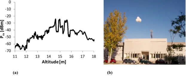
(a) (b)
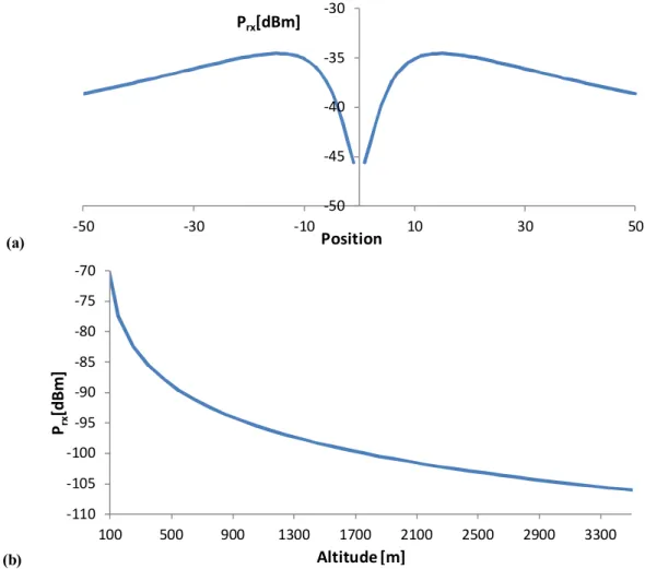
Fig. 1. Received power measurements in the 1800 MHz band (a) obtained using weather balloons (b). Within the scope of the SAAS project, we have proposed a new propagation model for computing the path loss in A2G links in outdoor urban scenarios [11]. The model was developed and validated for the frequency ranges of GSM (900 MHz), UMTS (1800 MHz) and LTE (2100 MHz) through several field trials and received power measurements in the vicinity of a BS using weather balloons. Fig. 1 shows a batch of samples obtained in the 1800 MHz band close to a BS located on the roof of a building with a height of 11 m. The altitude of the BS antennas was approximately 15 m and the downtilt angle was 10 degrees. Using multiple sets of measurements taken from different locations, a statistical analysis was performed. The results allowed us to extend a terrestrial propagation model through the adjustment of existing parameters and the addition of new ones, in order to fit it, as close as possible, to the behaviour of the real channel. This led to an empirical propagation model that can reproduce the average path loss between the transmitter and receiver as a function of distance, BS and terminal heights, frequency, tilt angle, elevation, azimuth and sectorization (more details can be found in [11]). Based on the propagation model, Fig. 2(a) shows the profile of the average received power (Prx) as a function
-70 -60 -50 -40 -30 -20 -10 0 11 12 13 14 15 16 17 18 Altitude [m] Prx [d B m ]
of position (BS is located at the origin) for an altitude of 19 m and Fig. 2(b) shows the profile as a function of the altitude of the UAV for a fixed horizontal distance to the BS of 8 m.
(a)
(b)
Fig. 2. Profile of the average received power (a) as a function of position along an horizontal line and (b) as a function of UAV altitude.
Besides the expected decrease of received power with increasing distance, an abrupt drop is visible above the BS which can be explained by the antenna pattern and respective downtilt. It is important to highlight that even though a UAV located over this ‘hole’ is basically at the centre of the cell, it is possible that a stronger signal can be received by a neighbour BS, which may result in a handover. In fact, when the altitude increases, the handover probability will tend to be higher. By inspection of Fig. 2(b) we can see that, for a typical LTE receiver sensitivity of -100 dBm, a maximum altitude around 1.7 km could theoretically be supported.
-50 -45 -40 -35 -30 -50 -30 -10 10 30 50 Position Prx[dBm] -110 -105 -100 -95 -90 -85 -80 -75 -70 100 500 900 1300 1700 2100 2500 2900 3300 Prx [d B m ] Altitude [m]
C. Device to Device Communication
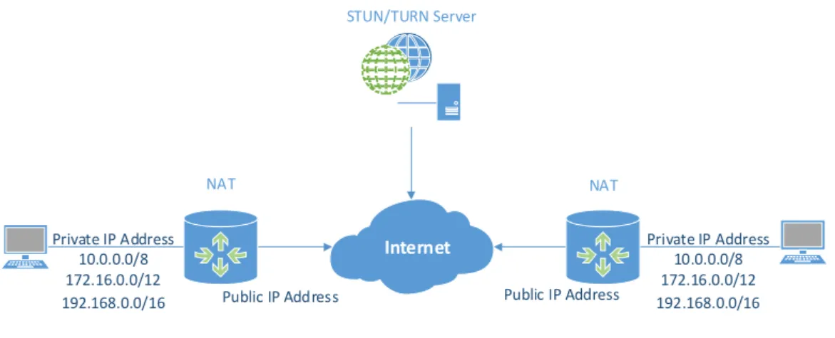
When establishing a connection between two devices over the Internet some difficulties can arise due to the network architecture. This is particularly true when direct communication is expected between UAVs and GCSs, and possibly when they are placed in different mobile networks. To overcome IPv4 address scarcity, most operators have resorted to private networks and use network address translation (NAT) when communication to the Internet is necessary, as shown in Fig. 3. Unfortunately, NAT is not standardized, creating interaction difficulties due to the diversity of NAT rules that may be used. This raises security problems by the possible fracture in the communication between hosts and third party servers that implement NAT traversal protocols. Basically this can lead to a connectivity problem between two peers, especially if both peers are placed behind certain types of NAT.
Internet Public IP Address Private IP Address 10.0.0.0/8 172.16.0.0/12 192.168.0.0/16 Private IP Address 10.0.0.0/8 172.16.0.0/12 192.168.0.0/16 Public IP Address STUN/TURN Server NAT NAT
Fig. 3. NAT as an interface between a private network and a public network.
While a full and rapid deployment of IPv6 could be the ideal solution to overcome all the problems raised by the use of NATs, in the meantime, to allow devices to establish peer-to-peer communications, one has to circumvent these problems by using NAT traversal techniques. Due to the wide range of NAT implementations, several traversal tools, methods and protocols usually employed on client-server applications (Fig. 3) have been developed over time, such as:
Session traversal utilities for NAT (STUN) protocol, RFC5389, which is used for detecting the presence of NAT and the public IP address. It works for the least problematic NAT implementations, but unfortunately it is not a complete solution, particularly on networks masqueraded by symmetric NAT.
Traversal using relays around NAT (TURN) protocol, RFC5766, which is used for relaying data between hosts in the presence of a NAT with address and port dependent mapping and filtering rules [12]. This type of NAT maps every internal request to a unique external IP and port, preventing the communication from the public side. TURN provides devices not only with the tools to control the operation of the relay but also to exchange data with other devices using the relay.
Interactive connectivity establishment (ICE), RFC5245, is a protocol that provides a full NAT traversal solution. It helps devices on discovering enough information about their network topologies and possibly finding a communication path using other protocols such as STUN and TURN [12].
In a typical scenario, connections between UAVs and GCSs may have to resort to different mobile networks. In order to deal with the possible presence of NATs, communication modules must implement NAT traversal techniques for establishing direct or relayed connections.
D. Fail-safe Mechanisms
When exploiting mobile radio infrastructure and a packet-switched network such as the Internet, there are performance issues that are relevant for real time communications, namely latency, packet loss and jitter, which can impact the UAVs’ operation and make manual flight potentially unsafe. Therefore, in order to deal with network delays and possible low reliability of the connection, the operation of UAVs under these networks should be based on autonomous and semi-autonomous flight modes.
Furthermore, as multiple 3G/4G networks are often available, the probability of losingradio coverage can be reduced by designing a UAS that operates with several simultaneous communication links. However, as the communication can still fail, additional fail-safe mechanisms can be implemented. A possibility is to incorporate the UAV with the capability of performing self-rescue by backtracking. While the vehicle is airborne, if a loss of connectivity is detected and the link is not re-established, a local command can be executed by the flight controller in order to 1) fly to the last geolocation with radio coverage using the same route or 2) decide for an emergency landing. Other solutions exist such as the one proposed in [13], where a path planning algorithm based on the A* algorithm is used so as to maintain a continuous communication link with the vehicle. This solution requires previous knowledge about the network’s cells conditions, which is not always possible.
E. Monitoring and Controlling UAVs
Remotely operating UAVs requires specific application level protocols for executing monitoring, control and mission command functions. There are various protocols available for the communication between MAVs and GCSs, e.g., UAVTalk, used by the OpenPilot platform, Micro Air Vehicle Communication Protocol (MAVLink10), adopted by the popular APM, and Ivy, implemented in the Paparazzi platform. These protocols provide a specific format for the transmission of telemetry, e.g., GPS position, IMU measurements, speed, barometric readings, battery status and commands. They define a set of telemetry messages, the encapsulation method and state machine for transmission of information over a serial communication channel, wired or wireless. To give an idea of the communication requirements, the MAVLink protocol defines the telemetry messages as arrays of 8 to 263 bytes, transmitted with a frequency of up to 20 Hz. Therefore, the telemetry streams will require bitrates up to 42 kbps.
10 MAVLink, Micro Air Vehicle Communication Protocol. [Online]. http://qgroundcontrol.org/mavlink/start
As mentioned before, a video stream is often necessary when controlling a UAV in order to assess the environment where the vehicle is deployed. The bitrate required to receive video with acceptable quality may typically lay between 200 kbps and 800 kbps, depending on the codec used, frames per second (fps) and video bitrate. Many different protocols may be used for streaming video over IP networks. A protocol extensively employed is the real-time transport protocol (RTP), RFC 3550, encapsulated typically over the user datagram protocol (UDP). However this may create problems when traversing firewalls. For this and other reasons, HTTP live streaming (HLS)11 and other competing alternatives are becoming increasingly popular. Not only because they facilitate better connectivity but also because they adapt better to network conditions by enabling adaptive bitrate streaming over HTTP. However, RTP, HLS or similar alternatives are only defined for encapsulating the encoded data, which for video can be based on H.261, H.263, H.264 and MPEG-4 standards.
IV. FLEXIBLE UAS ARCHITECTURE
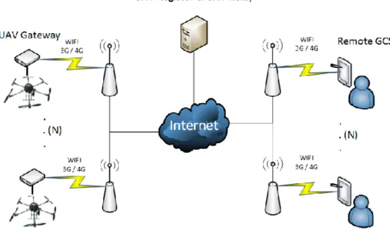
In Fig. 4 we present a flexible UAS architecture for multiple UAVs and GCSs where radio links can be established through cellular networks. The system comprises the following three main modules:
UAV Register & UAV Relay are applications located in a ground located server. The UAV Register is used for registering and exchanging network information from each UAV Gateway and Remote GCS module, such as IP addresses and the identification of the flight controller. The UAV Relay is used for the implementation of NAT traversal protocols, namely TURN. It can also be used for efficient IP multicast management between multiple vehicles and GCSs, with possible simultaneous radio connections. UAV Gateway behaves as an interface, intended to establish a connection between the
local flight controller and the Remote GCS. This module, located in the vehicle, is
responsible for NAT discovery procedures, UAV registration in the UAV Register module, verifying the connectivity to the network and maintaining a continuous connection between the Remote GCS module and the flight controller.
Remote GCS is the module that centralizes information from the vehicles, receiving telemetry and video streams. Similarly to the UAV Gateway module, it has several network functions such as discovering the NAT and registering network information.
Fig. 4. Flexible UAS architecture with support for cellular radio and other access technologies, multiple operators and multiple UAVs.
Although designed with the aim of exploiting mobile radio networks, the proposed architecture is transparent to the access technology in the sense that any of the vehicles, through the UAV Gateway module, or in the case of the GCSs, through the Remote GCS module, can use either 3G/4G, IEEE 802.15.4, WiFi, a dedicated link or even a wired connection (for a GCS). In fact, both the UAV Gateway and the Remote GCS can integrate multiple radio connections that can operate simultaneously in case of overlapping coverage and increase the reliability of the system.
The possibility of dynamically choosing a communication link in order to improve reliability of UAV communications was also discussed in [14].
Although this architecture is presented in the scope of A2G communications, it can be extended for air-to-air communications between multiple UAVs, as this functionality can be implemented in the UAV Gateway. In this case the UAV Gateway also acts as an interface between the ground radio network and an airborne network, which allows the adoption of a device-to-device (D2D) communication approach [15] that can extend the cellular coverage through multi-hopping as well as the support of coordinating and swarming functionalities between multiple UAVs [2][16].
V. EXPERIMENTAL SETUP and RESULTS
In order to assess the use of mobile networks, the UAS architecture proposed in Fig. 4 was implemented and tested. Flight tests were performed according to the mission plan shown in Fig. 5(a), and using the hexacopter vehicle, shown in Fig. 5(b). The duration of each flight lasted around 5 minutes, covering a total path length of 1760 m (4 laps of 440 m) with speeds varying between 1-8 m/s. The altitude ranged from 10 to 100 m above ground level which are common values for civilian applications. In our implementation we adopted the APM as the UAV flight controller and part of the experiment consisted in using the MAVlink msg_ping message to measure the round-trip time (RTT) at the Application Layer. A 4G smartphone was used for the implementation of the UAV Gateway. Three different wireless access technologies were tested, namely EDGE, HSPA+ and LTE, for two different situations:
best case scenario, where the UAV and the GCS were connected to the same BS, communicating without a relay (Remote GCS with a public IP address and the vehicle behind a port restricted cone NAT);
worst case scenario, where the UAV and the GCS were connected to different BSs and used the UAV Relay module to communicate.
(a)
(b)
Fig. 5 Mission plan in 2D (a) and in 3D (b), with the UAV prototype used for the flight tests.
Several received power (Prx) and quality of service measurements, namely the average RTT and
jitter (evaluated as the RTT standard deviation and peak values), were taken during the flight tests. Table 2 summarizes the results. The Prx values depend on the particular BS serving the
UAV for each wireless technology and are mostly useful for correlation with the RTT measurements. As expected, there are relevant differences between the different mobile technologies with LTE providing the lowest latencies and jitter (RTT of 127 ms and standard deviation of 48 ms for the worst case scenario) and EDGE having the worst results (RTT of 430 ms and standard deviation of 176 ms). Although in the worst case scenario the received power level only showed a decrease in average value for HSPA+, the average RTT and jitter increased for the three technologies. This is due to the use of the relaying module which requires the packets to travel a longer path. Even though in both scenarios the measured latencies and jitter
can be considered excessive for manual control, especially in the case of HSPA+ and EDGE, they are perfectly suitable for semi-autonomous flight modes. In fact, during the tests it was observed that in these modes the latency had no perceived impact on the monitoring and controlling functions of the vehicle.
Table 2. Performance measurements obtained during the flight tests.
Scenarios Mobile Technologies
Prx (dBm) RTT (ms) Jitter (ms)
avg max min avg std.dev max min
Best case EDGE -71.29 -59 -93 410.98 152.47 839.25 235.13 HSPA+ -68.07 -55 -91 135.42 47.62 487.32 82.52 LTE -85.34 -75 -104 86.10 29.61 313.61 46.01 Worst case EDGE -64.38 -53 -79 429.61 175.76 1738.12 273.00 HSPA+ -85.17 -59 -97 180.67 137.87 1572.28 105.52 LTE -80.36 -72 -106 127.34 48.24 420.78 81.46
During the tests, the observed data rates associated with the reception of telemetry, averaged around 8 kbps with peaks of 27.2 kbps while the transmission rate from the GCS was mostly below 4 kbps (the GCS sends periodic heartbeat messages at a frequency of 1Hz while commands are only sent when the operator wants to execute a manoeuvre). This shows that a communication protocol for MAVs like the MAVlink can be used in low bitrate channels and it is not particularly demanding for current wireless technologies. When a video stream encoded with a resolution of 320x240 pixels and 20 fps was also being received, the overall data rates achieved an average of 272 kbps, with peaks of 585.6 kbps, well below the maximum rates of HSPA+ and LTE (Table 1). Therefore this functionality seems entirely supportable with these technologies and higher quality video encodings or additional streams are even possible. Finally, it is important to highlight that tests performed on other scenarios also revealed results similar to those just described.
VI. FUTURE MOBILE TECHNOLOGIES
While further performance assessments are still required concerning the use of 3G and 4G cellular networks for UAV communications, it is important to discuss what should be expected from future mobile networks in this context. With several research studies already underway regarding the design of upcoming 5G mobile networks [17], it is very likely that UAV communications may benefit even further with the future deployment of these networks. Although not all the key technologies and scenarios driving 5G research are particularly relevant for UAVs, some may be particularly tailored for them, namely those that aim at:
Higher capacity, data rates and extended coverage, through the use of more spectrum (higher frequency bands, unlicensed spectrum, carrier aggregation techniques), advanced physical layer techniques (higher spectral efficient modulation and coding schemes, massive multiple input multiple output antennas - MIMO, interference mitigation techniques, new waveforms and multiple access schemes), integration of multi radio access technologies, native support for D2D and vehicle-to-X (V2X) communications and nomadic cells [17][18]. It is important to note that while higher data rates may not be significant for telemetry they can support higher quality video streams coming from one or more airborne cameras.
Low latency and high reliability through redesigned air interfaces, network architecture, protocol stack, backbone, backhaul and traffic optimization techniques. End to end latencies of 1ms with high reliability are envisioned which could improve the response time of the vehicles to remote commands and enable real-time manual operation.
Some of these enhancements will start to be incorporated into the next releases of LTE-A, namely carrier aggregation, massive MIMO, D2D communications, machine-type communications and LTE over unlicensed spectrum. These enhancements should allow an improved support for UAV communications even before 5G networks start to be deployed.
VII. CONCLUSIONS
In this article we presented an overview of UASs for civil applications focusing on the communication component. We identified several available communication technologies for UAVs, their constraints and also protocols available for implementing the remote operation of the vehicles. As an attractive solution for the A2G communication link for UAVs we discussed the potential of mobile networks with their fully deployed infrastructures, wide radio coverage, high throughputs, reduced latencies and large availability of radio modems. We described how a UAS can be implemented in a flexible and modular approach that allows it to rely on one or several wireless (UAVs and GCSs) and wired (GCSs) technologies.
Despite the advantages of a system based on cellular and IP networks, there are problems that must be dealt with, namely, possible loss of radio coverage, presence of NAT, delay, jitter and packet loss. Following the proposed architecture, we implemented an UAS and conducted some flight tests, which showed that the operation of the vehicles in semi-automatic or fully automatic modes is feasible. It is expected that future enhancements for 4G networks and evolution to 5G will benefit UAV communications even further with lower latencies, higher throughput and higher reliability.
VIII. ACKNOWLEDGMENTS
This work was partially supported by the SAAS (Remotely Piloted Semi-Autonomous Aerial Surveillance System Using Terrestrial Wireless Networks) project which was funded by the Instituto de Telecomunicações and the FCT - Fundação para a Ciência e Tecnologia (PEst-OE/EEI/LA0008/2013).
REFERENCES
[1] I. Bekmezci, O. K. Sahingoz, and S. Temel, “Flying Ad-Hoc Networks (FANET): A Survey,” Ad Hoc Networks, vol. 11, no. 3, pp. 1254–1270, May 2013.
[2] T. Andre, K. Hummel, A. Schoellig, and E. Yanmaz, "Application-driven design of aerial communication networks," IEEE Communications Magazine, vol. 52, no. 5, pp. 129 - 137, May 2014.
[3] R. Austin, Unmanned aircraft systems: UAVS design, development and deployment. Chichester : Wiley, 2010.
[4] H. Lim, J. Par, D. Lee, and H. Kim, "Open-Source Projects on Unmanned Aerial Vehicles: Build Your own quadcopter," IEEE Robotics and Automation Magazine, vol. 19, no. 3, pp. 33 - 45, 2012.
[5] E. Yanmaz, S. Hayat, J. Scherer, and C. Bettstetter, "Experimental Performance Analysis of Two-Hop Aerial 802.11 Networks," in IEEE Wireless Communications and Networking
Conference (WCNC), Istanbul, Turkey, 2014, pp. 3118-3123.
[6] J. Jang and D. Liccardo, "Small UAV Automation Using MEMS," IEEE Aerospace and
Electronic Systems Magazine, vol. 22, no. 5, pp. 30 - 34, May 2007.
[7] M. Ilarslan, M. K. Bayrakceken and A. Arisoy, " Avionics System Design of a Mini VTOL UAV," IEEE Aerospace and Electronic Systems Magazine, vol. 26, no. 10, pp. 35 - 40, October 2011.
[8] E. Frew and T. Brown, "Airborne Communication Networks for Small Unmanned Aircraft Systems," Proceedings of the IEEE, vol. 96, no. 12, pp. 2008 - 2027, 2008.
[9] K. Daniel and C. Wietfeld, "Using Public Network Infrastructures for UAV Remote Sensing in Civilian Security Operations," in Homeland Security Affairs (HSAJ), March, 2011.
[10] C. Cox, An Introduction to LTE : LTE, LTE-Advanced, SAE and 4G Mobile
communications. Chichester: Wiley, 2012.
[11] T.Tavares , P. Sebastião , N.S. Souto , F.C. Cercas , M. A. Ribeiro , A. Correia , F. J. Velez , “Generalized LUI propagation model for UAVs communications using terrestrial
cellular networks” , IEEE Vehicular Technology Conf. - VTC-Fall , Boston MA , United States , September , 2015.
[12] Y. Lin, C. Tseng, C. Ho, and Y. Wu, "How NAT-compatible are VoIP applications?,"
IEEE Communications Magazine, vol. 48, no. 12, pp. 58 - 65, 2010.
[13] T. Chi, Y. Ming, Tseng, and S. Kuo, "Civil UAV Path Planning Algorithm for Considering Connection with Cellular Data Network," in IEEE 12th International Conference on
Computer and Information Technology (CIT), Chengdu, October 2012, pp. 327 - 331.
[14] E. Pastor, J. Lopez and P. Royo, "UAV Payload and Mission Control Hardware/Software Architecture," IEEE Aerospace and Electronic Systems Magazine, vol. 22, no. 6, pp. 3 - 8, June 2007.
[15] G. Fodor et al., "Design aspects of network assisted device-to-device communications,"
IEEE Communications Magazine, vol. 50, no. 3, pp. 170-177, March 2012.
[16] M. Asadpour, B. Bergh, D. Giustiniano, and K. Hummel, "Micro aerial vehicle networks: an experimental analysis of challenges and opportunities," IEEE Communications
Magazine, vol. 52, no. 7, pp. 141 - 149, July 2014.
[17] A. Osseiran, F. Boccardi, V. Braun, K. Kusume, and et. al., "Scenarios for 5G Mobile and Wireless Communications: The Vision of the METIS Project," IEEE Communications
Magazine, vol. 52, no. 5, pp. 26-35, May 2014.
[18] P. Agyapong, M. Iwamura, D. Staehle, W. Kiess, and A. Benjebbour, "Design Considerations for a 5G Network Architecture," IEEE Communications Magazine, vol. 52, no. 11, pp. 65-75, November 2014.
![Table 1. Theoretical data rates and latencies for mobile cellular technologies [10].](https://thumb-eu.123doks.com/thumbv2/123dok_br/18206022.876357/6.892.139.756.909.1055/table-theoretical-data-rates-latencies-mobile-cellular-technologies.webp)