circulatory ratio (Rc), Stream frequency (Fs), Elongation ratio (Re), form factor(Rf), total basin relief (Rr) relief ratio (Rh) of the basin are computed using standards formulae suggested by Horten (1932, 1945), Miller (1953), Schumm (1956) and Strahler (1957). The lineament data collected from topographical maps and straight segments of streams were traced by method proposed by OLeary (1976). The lineament data were collected from all order streams present in basin with help of topographical maps. The accuracy of analysis and the preparation of maps are dependent on the scale lithology and structural characteristics of study area. Study area. Hydrometeorology. The climate of basin on the whole is semi-arid to sub-humid. The winter season is from December to middle of February followed by summer season (February to May) and June to September is the south-west monsoon season, whereas October and November constitute the post-monsoon season. The mean minimum temperature is 14.4 °C to 18 °C and mean maximum temperature is 36.8°C to 40°C in area with average of 23-24°C. Average annual rainfall is 1800 mm in the area.
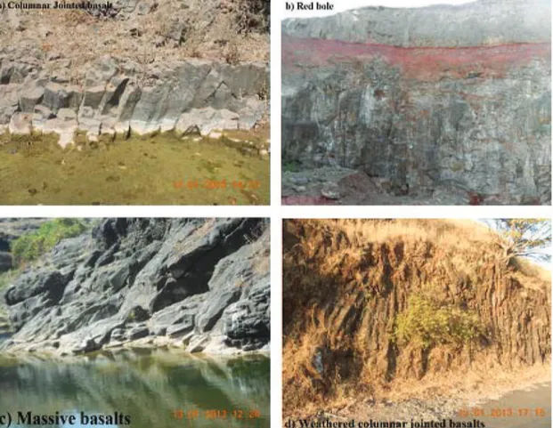
Geology. Study area is geologically covered by Deccan Volcanic Province of India. In this area there are six different types of basaltic lava flows, while topmost layer is generally red clayey material, called as red bole (GSI, 1987). Due to impact of the temperature, water and climate basalt is converted into the laterite and capped on basalt. Hilly area has been found to be extensively capped by laterites. It is residual product of deep chemical weathering. Generally laterites exhibit a porous, pitted and earthy appearance with red, yellow, brown to grey mottled colour, invariably with limonite as a crust. Stratigraphic successions of Tarali river basin were presented in Table 1 and Fig. 1.
Int. j. econ. environ. geol. Vol:4(1) 21-26, 2013
ÓSEGMITE
Available online at www.econ-environ-geol.org
Introduction
In India day by day demand of water is increasing due to growing population, increasing industrialization, rapid urbanization and agricultural irrigation. The demand for water multiplying is leading to the scarcity problem. The water scarcity is also increasing problem of water pollution and over exploitation of groundwater in certain areas. Due to rainfall variation and water deficiency at some places water is supplied with the help of tankers. Thus, management of water resource is essential. In this regard neo-tectonic activities were studied with the help of lineament and morphometric analysis of Tarali River basin which is tributary of Krishna River Basin, western India. The neo-tectonics indicates faulting and upliftment of landmass form during recent years which controls geomorphology of area and also drainage patterns. Geomorphological and tectonic settlement of area helps in various factors which is useful for management and planning of basin development. Drainage morphometry will signifying the construction sites for artificial recharging structures for implication of hydrology (Golekar et al, 2013 and Babar, 2005).
Methods of field studies. Topographical maps covering the area are enlarged to scale 500m=1cm. The different geomorphological and hydrological units are observed. As reference and base map preparation, four SOI toposheets (47 G/14, 47 G/15 47 K/2 and 47 K/3) on 1:50000 scales in paper format were used. The order was given to each stream followed by Strahler (1957) stream ordering technique. Analysis of various drainage parameters namely ordering of the various streams and measurement of area of basin, perimeter of basin, length of drainage channels, drainage density (Dd), drainage frequency, bifurcation ratio (Rb), texture ratio (T) and
Lineament and Morphometric Analysis for Watershed Development
of Tarali River Basin, Western India
Vikrant Bartakke
1, R. B. Golekar
1*, M. V. Baride
2,
S. N. Patil
1, R. A. Suryawanshi
31
Department of Civil Engineering, Shri Chhatrapati Shivaji College of Engineering, Rahuri,
District Ahmednagar-413706 (M.S), India
2
Department of Geology, Z. B. Patil College, Dhule, India - 424002
2Department of Geology, Y. C. College, Karad, District Satara, India - 415124
*
Email: [email protected]
The lava flows are Aa, pa-hoe-hoe, megacryst, simple and mixed. These lava flows contain predominantly compact (massive) basalt, also columnar basalt and red boles found at some places (Fig 1). Volcanic vents and volcanic breccias are very common in the area under study. The compact basalt is showing spheroidal weathering and basalt contains red bole observed at lot of places. The sediments are found at base of hills, bank of river and streams. Sediment contains unconsolidated, consolidated sediments, soil and alluvium.
Geomorphology. The area is covered by Deccan Plateau of Sahyadri ranges i.e. the residual hills ranges, well developed table lands and intermediate valleys forms the main geomorphic elements present in the basin area. The river has largely been controlled by structural underlying basalt flows. Many streams are characterised by the straight segments. The rose diagram is constructed for straight segment of stream recorded on the fact that many streams are fractural controlled. The geomorphological and climatic characteristics of a basin govern its hydrological response to a considerable extent.
The geomorphological characteristics of a basin represent its attribute, which may be employed in synthesizing its hydrological response. The importance of geomorphic factors like basin shape and relief which cannot be overlooked in accurate prediction of runoff. Basin characteristics when measured and expressed in quantified geomorphic parameters can be studied for their influence on runoff. Hence, lining of the geomorphic parameter with the hydrological characteristic of basin can lead to simple and useful procedure to simulate the hydrological behaviour of various basins, particularly the engaged ones. Interpretation and quantitative analysis of various drainage parameters enables qualitative evolution of surface runoff, infiltration and susceptibility to erosion within the basin.
Geohydrology. The weathered and fractured traps occur in topographic lows form the main aquifer in the basin. The groundwater occurs under phreatic, semi-confined and unconfined conditions. Generally the shallower zones down to the depth of 20 m below ground level form phreatic aquifer. The water bearing zones occurring Fig. 1. Outcrop features illustrating the basalts and associated rocks from the Tarali river basin, India
Vikrant Bartakke et al;/Int. j. econ. environ. geol. Vol:4(1) 21-26, 2013
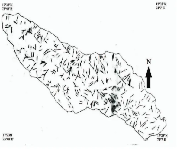
streams are characterised by straight segment with straps angles. The lineaments map prepared (Fig. 3) with the help of topographical maps. The lineaments data from the topographical maps are given in Table 2from Azimuth frequency that lineaments do not show any pronounced concentration in any direction. The maximum numbers of lineaments are observed at range of 351° to 360° from the North.
Rose diagram in Fig. 4 is constructed based on lineament data from topographical map sheets. Maximum development has Azimuth range 351°-360° N. The lineaments are marked from drainage pattern that, courses of many streams are structurally controlled. It is observed from rose diagram that maximum development lies 351° -360° N direction with 10.50% and 41 in the form of numbers, whereas sub maximum lies at 0°-10°, 31° -40°and 41°-50° with 30,28 and 30 numbers respectively and 7.69, 7.18 and 7.69 % straight segments are developed in the area. It is seen from Azimuth diagram that lineaments are NW-SE and NE-SW oriented fractures of shear origin.
Analysis of lineament from topographical sheets gives significant information about tectonic activity which has affected the area of study. The data show maximum development in 351°-360° N appears to be major direction of structural weakness. This lineament analysis of area matches with the major regional structural trends of India. The Rose diagram of lineament pattern from topographical maps, suggests the direction of major structural weakness is present at N - S and NE - SW. Linear and aerial parameters of Tarali River Basin (Krishna Sub basin) are given in Tables 3 and 4 respectively.
The 6th
order basin is showing dendritic to sub- parallel between the depths of 20 and 40 m are weathered interflow
or shear zones and yield water under semi-confined conditions. Deep confined aquifers occur below the depth of 40 m.
The vesicular portion of different lava flows varies in thickness from 8 to 10 m and forms the potential aquifer zones. However the nature and density of vesicles, their distribution and interconnection, depth of weathering and topography of the area are the decisive factors for occurrence and movement of groundwater in vesicular units. The massive portion of basaltic flows are devoid of water, but when it is weathered, fractured, jointed or contain weaker zones, groundwater occurs in it. Results and Discussion
The area of basin is drained by the streams which originated in Sahydri Ranges of the Western Ghats. Majority of streams flow in NW-SE direction, some flow towards W-E and NE-SW direction. Most of streams are showing straight segment which indicate structural control. Major tributaries are originated in southern part flowing towards northern direction. All these tributaries form dendritic drainage pattern, also showing sub-parallel drainage pattern. Drainage morphometry map of Tarali river basin is shown in Fig. 2.
A lineament is a linear feature in a landscape which is an expression of an underlying geological structure such as a fault, fracture zones and shear zones. Origins may be radically different from those of terrestrial lineaments due to the different tectonic processes involved. The lineament map is useful in evaluating the tectonic history of the continental area. Geomorphology and lineament pattern shows the tectonic activity in the area. Many
drainage pattern form due to moderate to high run-off in area. The morphometric parameters indicates the Tarali Basin is elongated basin and with fine drainage texture. The area is showing homogeneity in geological characters with steep slope and high relief. The streams in area flowing
for longer duration but low discharge run-off and high permeability of subsoil condition. The area is structurally controlled at N-S and NE-SW direction. The streams in the area flow towards NW-SE direction and elevation range present in area is 584 -1171M from mean sea level. Fig. 3. Lineament diagram of Tarali river basin, Maharashtra, India
Vikrant Bartakke et al;/Int. j. econ. environ. geol. Vol:4(1) 21-26, 2013
Conclusion
The computed morphometric parameters shows that lower order streams mostly dominate in the basin. The river network is of sixth order and general drainage pattern is dendritic. The drainage density of the basin indicates that the general nature of rocks is medium pervious. The average bifurcation ratio of the area is 3.954 indicates an abnormal value because of high gradient of the basin. The value of bifurcation ratio indicates that the area is slightly hilly with high gradient. The values of the circularity show a no-circular and highly elongated nature of the basin.
The lineament density reveals the variations of groundwater potentiality in the basin. The high lineament density areas are found in the central portion of Tarali
river basin indicating high groundwater potential. The medium lineament density indicates the moderate groundwater potential in the upper part of the basin. The central part of Tarali river basin is suitable for constructing the small dam for groundwater development. Acknowledgement
Authors officially acknowledge North Maharashtra University, Jalgaon, Maharashtra, India. The authors would like to thank reviewers for their valuable comments and suggestions, which improved the quality of this manuscript.
References
Babar, Md. (2005) Hydrogeomorphology. Fundamentals Table 3. Linear aspects of the Tarali river basin Satara district Maharashtra, India
Application and Techniques a Text Book, pp 137-138, New India Publishing Agency, New Delhi, India.
Golekar, R.B; Baride, M.V; Patil, S. N. (2013) Morphometric analysis and hydrogeological implication: Anjani and Jhiri river basin Maharashtra,
India Archives of Applied Science Research, 5, 33 41.
Horton, R.E. (1945) Erosional development of streams and their drainage basins: Hydrophysical approach to quantitative morphology, Geological Society of America Bulletin, 5, 275-370.
Horton, R.E. (1932) Drainage basin characteristics,
Tansactions of American Geophysical Association, 13, 350-361.
GSI, (1987) Field Report on Geology of Parts of Pune and Satara District, Geological Survey of India Regional Geology Division Operation, Maharashtra,
p. 12.
Miller, V.C. (1953) A Quantitative Geomorphic Study of Drainage Basin Characteristics in the Clinch Mountain Area, Varginia and Tennessee, Project NR 389- 042, Tech. Rept.3., Columbia University, Department of Geology, ONR, Geography Branch, New York.
OLeary, D.W; Friedman. J.D; Pohn, H.A. (1976) Lineament linear, lineation. Some, proposed new definitions for old terms, Geological Society American Bulletin, 87, 1463-1469.
Schumm, S.A. (1956) The evolution of drainage systems and slopes in badlands at Perth Amboi, New Jersey,
Geological Society American Bulletin, 67, 597-646.