N U S A N T A R A B I O S C I E N C E ISSN: 2087-3948
Vol. 7, No. 2, pp. 112-117 E-ISSN: 2087-3956
November 2015 DOI: 10.13057/nusbiosci/n070209
Land suitability for endemic plants in Kiara Payung Biodiversity Park,
West Java
TINA SAFARIA NILAWATI♥, WAHYU SURAKUSUMAH, VITA ANNISYA
Department of Biology Education, Faculty of Mathematics and Natural Sciences Education, Indonesian University of Education (UPI). Jl. Dr. Setiabudhi No. 229 Bandung 40154 Jawa Barat. Tel./Fax: +62-22-2001108.
email: nilawati.ts@gmail.com
Manuscript was received: 27 August 2015. Revision was accepted: 23 October 2015.
Abstract.Nilawati TS, Surakusumah W, Annisya V. 2015. Land suitability for endemic plants in Kiara Payung Biodiversity Park, West Java. Nusantara Bioscience 7: 112-117. According to Bappenas data (2003), there are 38.000 species of plants, 55% of which are endemic, in Indonesia. However, in Indonesia, there is severe environmental deterioration which may cause extinction of endemic plants. One way to solve the environmental degradation is conducting ex situ conservation, such as the establishment of Kiara Payung Biodiversity Park in Sumedang, West Java, Indonesia. The aim of this research was to determine land suitability of the park for plantation of endemic plants of West Java, Bouea macrophylla, Blumeodendron tokbrai, and Pterospermum javanicum, based on climatic and edaphic factors using GIS Arcview software. The climatic and edaphic data were taken from the field, and then they were overlaid in land unit maps with other parameters of every endemic plant species in West Java based on literature review. All data were interpreted based on land evaluation method by matching process. The results showed that the endemic plantsB. macrophyllaand P. javanicumare not suitable to be planted in Kiara Payung Biodiversity Park, whileB. tokbraiis suitable to be planted in the entire blocks 5, 6, and 7 and part of blocks 2,3,4 and 8 of this park.
Keywords: ArcGIS, Biodiversity Park, endemic plants, land suitability, West Java
INTRODUCTION
Due to its high endemism, Indonesia is categorized as a country having unique habitats for tropical plants with their various phenomena. However, Indonesia is also known for its high environmental deterioration level, especially species extinction and habitat destruction which result in biodiversity decline. Based on the data from the Ministry of Forestry, the rate of forest degradation in Indonesia was 2.83 million hectares per year during 2000-2005 (Departemen Kehutanan 2005). According to Forest Watch Indonesia (FWI), the forest coverage of Java Island in 2009, was only 6.90% of the land, or 897,978.82 ha. Compared to the forest coverage in 2000, Java Island had undergone deforestation as much as 60.64% (FWI 2011).
One way to solve the environmental deterioration is conducting ex situ conservation, such as the establishment of Biodiversity Park in Sumedang District. Before it was established as a Biodiversity Park, the land had been used for various activities related to biodiversity conservation. Evaluation of the park in 2012 was conducted with several parameters: size, altitude, ecosystem type, selection of main species, number of each main species, the suitability of supporting species in creating continuity of food sources for pollinators, planting distance among plants related to their height and size of crown, and land use type of the buffer zone (Roemantyo 2012). However, there had been no evaluation of land suitability of the main plant species in the park. The aim of this research was to determine land suitablity of the park for plantation of endemic plants of West Java,Bouea macrophylla(gandaria), Blumeodendron
tokbrai (ki batok), and Pterospermum javanicum (bayur), based on climatic and edaphic factors using GIS Arcview software. It is hoped that the results of this study can be used for re-evaluation of the park and the park management can further develop this park to support environmental conservation using spatial data of land suitability for endemic plants more specifically from the available pixels. Then, the park management can determine which species should be planted.
MATERIALS AND METHODS
This study was a descriptive one, using geographic information system (GIS) software, Arcview. Geographic Information System is designed to work with spatial data or geographic coordinates (Huisman and Rolf 2009). In conservation, GIS is very important for preparation, monitoring, analyses and evaluation of conservation.
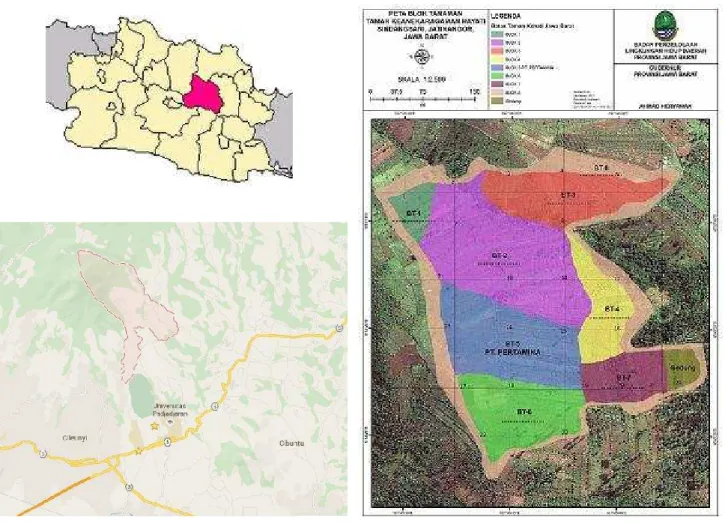
This study was conducted in February and June, 2014 in the Ecology Laboratory, Indonesian University of Education in Bandung and in Kiara Payung Biodiversity Park in Sindangsari Village, Sukasari Sub-district,
Sumedang District, West Java, Indonesia. The
measurements of climatic and edaphic parameters were done in 23 sites, each of which was separated 75 meters away from another (Figure 1). The measurements of organic parameters were done in the laboratory.
Figure 1.The map of sampling site distribution in in Kiara Payung Biodiversity Park in Sindangsari Village, Sukasari Sub-district, Sumedang District, West Java, Indonesia (BPLHD 2014)
sampling locations was based on the border of the park. Sampling was repeated 3 times for each site randomly. Literature review was also done to know the environmental requirement for the growth of plant species endemic to West Java (P. macrophylla, B. tokbrai, P. javanicum).
Climatic parameters measured in the field were relative humidity, temperature, light intensity and wind speed, while the edaphic parameters were soil moisture content, soil pH, soil temperature, soil aeration, topography and altitude. Tests of organic matter were done in the Ecology Laboratory, Indonesian University of Education. The spatial data were overlaid in land unit maps with other parameters of every endemic plant species in West Java based on literature review. All data were interpreted based on land evaluation method by matching process, namely comparing land characteristics and environmental requirement for growth to determine the land suitability.
RESULTS AND DISCUSSION
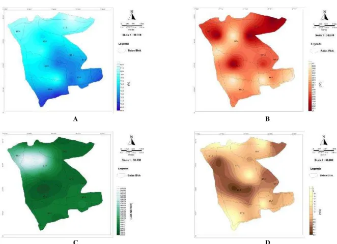
Field data were analyzed to make maps showing distribution of climatic and edaphic factors in the Biodiversity Park. The maps can also be used to determine the suitability of endemic plants.
Climatic factor
The relative humidity in Biodiversity Park varied widely from 68% to 82% (Figure 2A). The lowest relative humidity, 68%, was found in blocks 6 and 7, while the highest one, 82%, was recorded in block 8. The distribution pattern of temperature in the park is presented in Figure 2B. The air temperature was 25ºC-27ºC. The air temperature taken at 1110 m above sea level was 25ºC, while that at 1000 m above sea level was 27ºC. The lowest temperature, 25ºC, was found in several sites in blocks 2,3,5, and 8. The highest temperature, 27ºC, was found in several sites in blocks 2,5,6,7, and 8. The lowest light intensity, 20,000 lux, was found in block 5, whereas the highest one, 240.000 lux, was found in blocks 1 and 2. (Figure 2.C). The differences in light intensity among blocks were caused by tree stand density, as stated by Wertheim et al. (1986), light interception by the tree was linearly proportional to tree density. The relative humidity and air temperature in blocks 2 and 5 were similar because both block had the same altitude.
N U S A N T A R A B I O S C I E N C E 7 (2): 112-117, November 2015 114
0.3 m/s is categorized as class 1 (0.2 m/s-1.6 m/s) or light air and the wind speed of 2m/s is categorized as class 2 (1.9 m/s-3m/s) or light breeze. The light air is indicated by smoke direction, while light breeze is felt lightly by skin and causes slight movement of leaves. Based on Beaufort scales, the wind speed in the Biodiversity Park did not influence plant growth in every block because only strong wind may cause trees to fall and branches to break.
Edaphic factor
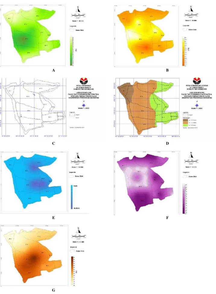
The soil moisture content ranged from 46 to 70% (Figure 3.A). The highest soil moisture content (70%) was found in blocks 1, 2, and 8. The range of soil moisture content in block 1 was between 66% and 70%. Parts of blocks 2 and 8 had soil moisture content between 66% and 70%, and the rest between 58% and 62%. The soil temperature ranged from 24oC to 26oC (Figure 3.B). The highest soil temperature (26ºC) was found in blocks 2,4, and 5, and the lowest one (23ºC) was found in part of block 5.
The highest soil moisture content was found in block 1 because the soil in this block was shaded by trees’ crown;
so, the sun light did not reach the soil surface. This finding is in accordance with that of Mulyana et al. (2011), stating that soil under thick vegetation had higher moisture content and lower temperature than soil with sparse vegetation.
The Biodiversity Park lies on 1010-1100 meter above sea level (Figure 3.C). The highest altitude, 1100 m, was
found in block 8, while the lowest one, 1010 m. was found in blocks of buildings and entrance of the park. The topographic map is presented clearly in Figure 3.D. The topography of the entire block 1 ranged from 26% to 40%. Parts of blocks 2 and 3 had topography between 6% and 25%, and the rest 8-15%. Most of the entire blocks 5 and 6 had topography of 16-25%, while the smallest parts 8-15%. The topography of whole blocks 4 and 7 was 8-15%, while that of block 8 ranged widely: 8-15%, 16-25% and 26-40%. Based on slope classification, the terrain of the Park belongs to class III (undulating), IV (rolling) and V (moderately steep). As a whole, the slope of the park which belonged to classes IV and V with a percentage >15% (rolling-moderately steep), as found in blocks 1, 2, 5, 6 and parts of blocks 3 and 8, had high potential for erosion; so, serious attention must be paid. The steeper the slope, the easier the soil particle rolls down due to raindrops, and so the erodibility will be high and vice versa (Arsyad 2000). The types of vegetation growing on the land affect erosion level because vegetation can protect soil surface from damage due to raindrops. Most blocks in the park were covered by grasses. According to Morgan and Rickson (2011), grasses can reduce erosion on slope. Dense plant coverage impedes the transport of soil by water. So, grasses will be needed in the parts of the park which will be planted with endemic plants.
A B
C D
A B
C D
E F
G
N U S A N T A R A B I O S C I E N C E 7 (2): 112-117, November 2015 116
A B
C
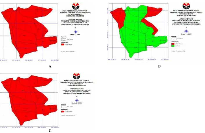
Figure 4.Land suitability map forBouea macrophylla(A),Blumeodendron tokbrai(B), andPterospermum javanicum(C) in Kiara Payung Biodiversity Park, West Java
The tests of soil aeration showed that the soil in the park had good aeration (Figure 3.E). The entire blocks 1,4,7 and 8 had good aeration. Only small parts of blocks 2,3,4 and 5 had bad aeration. The aeration tests showed that the soil in the park had good aeration which helps plants in respiration, resulting in energy used for synthesis and transport of organic compound to all parts of the plants. If the soil in the park is waterlogged, due to excessive irrigation or other causes, the plants will lack oxygen and wilt (Sairam et al. 2008).
The pH of soil in the Biodiversity Park ranged between 5.8 and 7.05 and was considered acidic to neutral soil (Figure 3.F). According to Jensen (2010), the ideal soil pH is close to neutral, and neutral soils are considered to fall within a range from a slightly acidic pH of 6.5 to slightly alkaline pH of 7.5. It has been determined that most plant nutrients are optimally within this 6.5 to 7.5 pH range. So, some areas at the park are not suitable to be planted without any treatments to the soil.
Organic matter content of soil in the park ranged 36% to 64% (Figure 3.G). When the organic matter content of a soil exceeds 20 to 35% (on a dry weight basis), it is considered organic soil material, and the soil is called an organic soil (Brady 1990). Therefore, soil in the Biodiversity Park is considered organic soil.
Land suitability for endemic plants of West Java The first endemic plant evaluated wasB. macrophylla. It can be concluded from Figure 4.A that this species is not
suitable to be planted in the Biodiversity Park. Based on literature review, it is known thatB. macrophyllanaturally grows in land with an altitude of 300m or more (Rivai 1992), but it can be cultivated up to 850m above sea level. It is suitable to grow in 8-45% slope, 14.8-22ºC air temperature, 55.3-68% relative humidity. The four parameters above do not match with edaphic and climatic factor of the park. Only one parameter, slope, matches with the requirement for plant growth ofB. macrophylla.
Based on matching processB. tokbrai is suitable for the entire blocks 5, 6, and 7 and small parts of blocks 2, 3, 4, and 8 (Figure 4.B). This species grows in altitude of 1300 m above sea level, air temperature of 22-32ºC, and relative humidity of 85-96%. So, the edaphic and climatic factors of this plant are similar to those found in the park. The suitability of plant character and the air temperature of the park will increase photosynthesis and respiration. According to Franklin and Wigge (2013), plants are incredibly sensitive to changes in temperature. Changes of a single degree or two in ambient temperature can impact plant architecture, developmental processes, immune response, and plant reproduction. In addition, other abiotic factors affecting plant growth are altitude and soil types. So, this species should be planted in this park.
55-98%, light intensity of 550-2401 lux, and soil pH of 3-5.5. The altitude is lower than that in the park, while the temperature is higher. So, the characteristics of climatic and edaphic factors where this plant grows do not match those in the Biodiversity Park. If this species is planted in the park, it will not grow and develop as well as in its natural habitat. Physiological and morphological changes of this plant will happen due to adaptation.
Based on the matching process of the overlaid maps, the climatic and edaphic factors of the Kiara Payung
Biodiversity Park do not match those where B.
macrophyllaandP. javanicumnaturally grow. So, there is no area in the park suitable to be planted with both species. B. tokbraiis suitable to be planted in the entire blocks 5, 6, and 7 and small parts of blocks 2, 3, 4, and 8. Due to lack of supporting data, such as requirement for plant lives, the uses of thematic maps were not maximal. It is recommended that more research on land suitability is conducted for other endemic species in West Java as references for the government to develop the Biodiversity Park.
REFERENCES
Arsyad S. 2000. Konservasi Tanah dan Air. UPT Produksi Media Informasi. Lembaga Sumberdaya Informasi. Institut Pertanian Bogor, IPB Press, Bogor. [Indonesian]
Bappenas. 2003. Strategi dan Rencana Aksi Keanekaragaman Hayati Indonesia 2003-2020. Dokumen Nasional. Pemerintah Republik Indonesia. [Indonesian]
BPLHD. 2014. Peta Blok Tanaman Taman Keanekaragaman Hayati Sindangsari, Jatinagor, Jawa Barat. Badan Pengelolaan Lingkungan Hidup Daerah Provinsi Jawa Barat, Bandung. [Indonesian]
Brady N. 1990. The Nature and Properties of Soils. Macmillan Publishing Company, New York.
DoF [Department of Forestry GoI]. 2005. Rekalkulasi Penutupan Lahan Indonesia Tahun 2005. Jakarta. Departemen Kehutanan Republik Indonesia. [Indonesian]
Franklin KA, Wigge PA. 2013. Temperature and Plant Development. Willey-Blackwell, New York.
FWI [Forest Watch Indonesia]. 2011. Potret Keadaan Hutan Indonesia: Periode Tahun 2000-2009. Forest Watch Indonesia. Bogor. [Indonesian]
Hardjowigeno S. 2007. Ilmu Tanah. CV. Akademika Pressindo, Jakarta. [Indonesian]
Huisman O, Rolf A. de B. 2009. Principles of Geographic Information Systems: An Introductory Textbook. 4th ed. ITC. Enschede The
Netherlands.
Jensen TL. 2010. Soil pH and the Availability of Plant Nutrients. IPNI Plant Nutrition Today: 2.
Morgan RPC, Rickson RJ. 2011. Slope Stabilization and Erosion Control: A Bioengineering Approach. Taylor & Fancis Group, New York. Mulyana D, Wilarso S, Basuki B, Sekar A. 2011. Perubahan lingkungan
mikro pada berbagai penutupan lahan hasil revegetasi.Artikel Tanah 17 (1): 24-25. [Indonesian]
Palys T. 2008. Purposive Sampling. In: Given LM (ed). The Sage Encyclopedia of Qualitative Research Methods (Vol. 2). Sage, Los Angeles.
Rivai MA. 1992.Bouea macrophylla Griffith. In: Coronel RE, Verheij EWM (eds.). Plant Resources of South East Asia No. 2: Edible Fruits and Nuts. Prosea Foundation. Bogor, Indonesia.
Roemantyo NM. 2012. Evaluasi Pembangunan Koleksi Taman Kehati Provinsi Jawa Barat. BPLHD Jawa Barat, Bandung. [Indonesian] Sairam RK, Kumutha D, Ezhilmathi K, Desmukh PS, Srivastava GC.
2008. Physiology and biochemistry of waterlogging tolerance in plants. Biologia Plantarum. 52(3):401-412.