INFORMATION SCIENCE AND AGRICULTURAL LAND SUITABILITY: INTERSCALAR APPROACHES FOR LAND USE PLANNING
Vitor Vieira Vasconcelos1 Paulo Pereira Martins Junior2 Abstract:
Technical and methodological innovations in programming, network sharing, information system analysis and geographic information systems (GIS) have enabled the representation, storage, processing and dissemination of information that was previously unavailable to interested parties. In this context, this study presents a proposal for the conceptual modeling of the integrated use of agricultural land suitability methods to develop support systems for land use decision-making information science methods. Knowledge-based modeling diagrams are structured using CommonKADS and Unified Modeling Language (UML) methods to simulate the processing of basic questions from farmers, including “what to plant”, “where to plant”, and “how to plant”. Finally, an interdisciplinary matrix, which explains the relationship between crop-specific agricultural land suitability and soil and terrain attributes to support decision-making at a detailed scale, is presented. The proposed system is an effective instrument for agricultural and environmental guidance and education because it provides environmentally sustainable alternatives to the user and explains the economic rationale for such proposals.
Keywords: Agronomy. Geographic Information Systems. Information Science. Decision-Making Support Systems. Environment.
1 INTRODUCTION
Land use planning for agricultural, forestry and pastoral activities has benefited over the years from suitability mapping techniques for rural economic activities. Some techniques that have traditionally been used include land use capability assessments (LEPSCH et al., 1991) and the Food and Agriculture Organization (FAO)/Brazilian Agricultural Land Suitability Evaluation System (RAMALHO FILHO and BEEK, 1995). Both methods provide a preliminary indication
1
Post-Doctoral Fellow at Stockholm Environment Institute, Asia Centre, Bangkok, Thailand – CNPq scholarship. PhD in Natural Sciences from Federal University of Ouro Preto, Ouro Preto, MG, Brazil, with sandwich PhD stage in Water Resources Engineering at Chulalongkorn University, Thailand. E-mail: vitor.v.v@gmail.com
2
of land suitability for different production activities under different management systems.
Crop-specific agroclimatic zoning is also used in the Brazilian agricultural environment. Typical examples include sugarcane (MANZATTO et al., 2009) and macadamia (SCHNEIDER et al., 2011) zoning, which focus on the possibilities of agricultural expansions of these crops in Brazil. Over the last decade, the Brazilian Agricultural Research Corporation (Empresa Brasileira de Pesquisa Agropecuária; Embrapa) has also conducted climate-risk agricultural zoning with the aim of supporting agricultural insurance (OZAKI, 2007), besides risk simulations based on climate change projections (ASSAD et al., 2013). The spatial distributions of humidity, rainfall and temperature restrictions and the risks of frost and other inclement weather conditions are characteristics of agroclimatic zoning (WOLLMANN and GALVANI, 2013).
Recently, a new type of mapping, ecological-economic zoning maps, has been added to rural expansion planning cartography, although the proper format of these methods is still a matter of academic debate (MARTINS JUNIOR et al., 2009). The attributes that are mapped include, at a minimum, the legal restrictions on territorial occupation (e.g., conservation units and permanent preservation areas); however, the maps may also reflect social agreements on the conservation of special areas, including ecological corridors and other key areas of conservation interest (BOLFE et al. 2015). Furthermore, the ecological-economic zoning concept is based on an attempt to integrate aspects of natural, social and economic resources into a regional proposal for sustainable development (VASCONCELOS et al., 2013). The breadth of its goals is challenging, especially regarding the epistemological limits of modern cartography.
1.1. Objectives
dissemination.
A conceptual framework to guide the development of spatial decision support systems (SDSSs) involving agricultural land suitability is proposed. The proposed knowledge framework aims to help: [1] meet the practical demands of government projects in watersheds, of environmental mitigation measures and of agricultural project planning, [2] answer a list of questions that are typically asked by users who have doubts about what should or should not be done on their farms given the geo-environmental conditions, [3] identify the problems in each farm by accessing cartographic and scientific databases to ensure that the answers are the most appropriate to the specific context, and [4] support both the landowner and the manager in developing a local-scale, sub-regional to regional rationale.
2 METHODOLOGY
The CommonKADS knowledge engineering method, which is used to deploy and manage knowledge-intensive systems (FAISAL et al., 2011), was used in this study. The Unified Modeling Language (UML; SEIDL et al., 2015), which is used in programming engineering (software) for standardized modeling of information and inference structures and is included in the CommonKADS method, was also used.
The process of acquiring and modeling data and information flows was developed from a joint study between experts in soil science and land planning from the Technological Center of Minas Gerais Foundation (Fundação Centro Tecnológico de Minas Gerais; CETEC-MG), the Minas Gerais Institute of Applied Geosciences (Instituto de Geociência Aplicadas de Minas Gerais; IGA) of the Federal University of Ouro Preto (Universidade Federal de Ouro Preto; UFOP) and Pontifical Catholic University of Minas Gerais (Pontifícia Universidade Católica de Minas Gerais; PUC-MINAS). The work was conducted based on the following research projects that focused on the Paracatu River Basin:
- the Water Resources Conservation in Drainage Basin Environmental and Agricultural Management [Conservação de Recursos Hídricos no âmbito da Gestão Ambiental e agrícola de Bacia Hidrográfica; CRHA] Project (MARTINS JUNIOR et al., 2006), which was funded by MCT/Finep – CT-Hidro (2002-2006).
- the Knowledge Architecture on Ecology-Economy [Arquitetura de Conhecimentos em Ecologia-Economia; ACEE] Project (MARTINS JUNIOR et al.,
- the Knowledge Architecture and Decision-Making Support Systems in Geoenvironmental and Economic Management of Drainage Basins and Farms [Sistemas de Arquitetura de Conhecimentos e de Auxílio à Decisão na Gestão Geoambiental e Econômica de Bacias Hidrográficas e Propriedades Rurais; SACD] Project (MARTINS JUNIOR et al., 2010), which was funded by Fapemig (2010-2011). The following knowledge acquisition methods were also used: texts, lists of concepts with their definitions, maps, tables, hierarchies, flow charts, organizational charts, diagrams and resolution of case examples (classical, actual and hypothetical cases). This variety of methods ensures that the experts express themselves in as diverse ways as possible because each form of expression reveals detailed knowledge that otherwise may be hidden. It is important to note that the reported knowledge derives not only from the acquisition by professional experts but also from other sources, such as books, articles, tables, files, databases, maps and GIS databases. These data complement the knowledge base of the proposed multi-expert system.
The study comprised the following stages:
1) Conceptual modeling of knowledge domains (vision, organization, and inference), tasks and communication (interface and module interaction) according to the CommonKADS method (FAISAL et al., 2011);
2) Use case diagrams in UML to support decision-making;
3) Object modeling for data structuring using context, class and activity diagrams in UML structure models; and
4) Systematization of agricultural land suitability criteria into an array of interdisciplinary knowledge.
3 DEVELOPMENT
The progressive development of cartographic databases that are available in GIS has enabled the development of logic-spatial algorithmic operations that are geared towards agricultural land suitability (AKINCI et al., 2013). These systems may be classified as spatial decision support systems (MEYER et al., 2013). By making GIS data available over networks (including the Internet), these tools may be useful to various interested users.
conceptual modeling is based on the theoretical foundations of Vasconcelos et al. (2005) and Martins Junior et al. (2006) under the proposals of the SisDec system. The following capabilities are combined:
- GIS enables users to visualize information about selected parcels of land, including both primary information and the results of calculations that are performed by expert algorithms. GIS also serves as the master database on which algorithms rely to produce simulations of agricultural land suitability and land planning. The interaction between GIS and SDSSs was conceptually modeled using the SIGea System (MARTINS JUNIOR et al., 2006).
- Conceptual databases may complement the information from expert systems and provide texts and didactic illustrations that help demonstrate the concepts and techniques that are used. In some instances, the texts may be provided in the SDSS interface; in others, a shortcut to specific information portals is indicated. The conceptual modeling of a conceptual database that incorporates correlation chains between economics and ecology, which is called SisOrci, was designed by Martins Junior et al. (2006) and developed by Martins Junior et al. (2007).
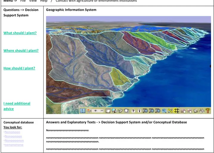
Figure 1 - Screen image simulation of the SDSS interface.
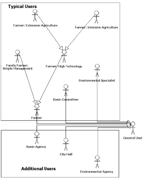
The identification of the type of user (e.g., farmer, drainage basin committee member, environmental expert) allows the selection of different methods of interaction between the interface system and the user. Thus, the available functions, language to be used for user-program communication, and additional useful guidelines conform to the profile of each user (Figure 2).
Figure 2 – Different user profiles with interests in agricultural land suitability information and land use planning.
Environmental interpreters may be given both the final products of the interpretation and intermediate products that will be useful for subsequent interpretations by the expert. This renders at least two response levels useful: one for the lay user and another for the expert user. The two levels have different communication formats.
labeled as such must be known.
Therefore, the advice and maps should always be accompanied by ecological, economic and social explanations that report the rationale behind the reason the answer was chosen. The explanations are provided for three main reasons: [1] to demonstrate the reliability and the basis of the answers to the user; [2] to present arguments to convince users to follow the advice; and [3] to act as an agricultural and environmental education tool that makes users more aware of the implications of their production activities.
The following integrated use capabilities, in their typical order, can be used in an expert system that integrates GIS and decision-making support algorithms:
1. Map the current land use;
2. Indicate the agro-climatological restrictions; 3. Indicate the environmental restrictions; 4. Indicate the legal restrictions;
5. Indicate the necessary conservation measures and how they may be economically beneficial;
6. Indicate the appropriate agricultural methods (including irrigation, soil correction and fertilization) for specific crops;
7. Map the optimal (optimized) use of the farm.
In the information modeling process, the use capabilities that are listed above were integrated into three specific use cases: [1] The question “what to plant”, which uses agroclimatological and soil suitability criteria; [2] the question “where to plant”, wherein the first question acquires a spatial dimension, and restriction criteria that are associated with the environmental and water resources characteristics of the area are considered; and [3] the question “how do I plant”, which directs the user towards specific advice regarding environmentally friendly farming methods and soil- and water-conservation methods based on information that is derived from the user's profile and the characteristics of the analyzed area.
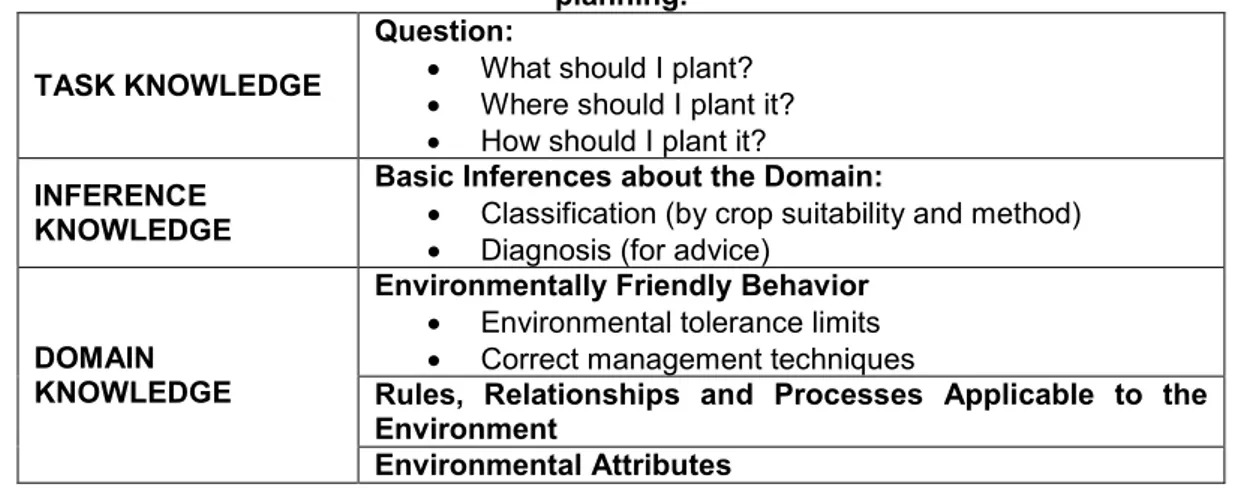
Table 1 – Knowledge levels involved in the domains of agricultural land suitability and land use planning.
TASK KNOWLEDGE
Question:
What should I plant? Where should I plant it? How should I plant it? INFERENCE
KNOWLEDGE
Basic Inferences about the Domain:
Classification (by crop suitability and method) Diagnosis (for advice)
DOMAIN KNOWLEDGE
Environmentally Friendly Behavior Environmental tolerance limits Correct management techniques
Rules, Relationships and Processes Applicable to the Environment
Environmental Attributes
Figure 3 shows the basic variables that are manipulated in the database. The goal is not to exhaust the possible variables to be used but rather to demonstrate their nature and the basic relationship between the variable groups.
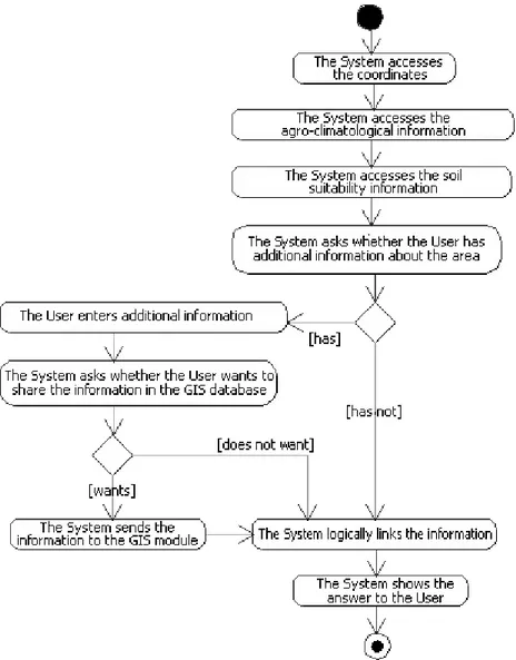
Figure 3 – Class diagram showing the objects and variables that are manipulated by the SDSS.
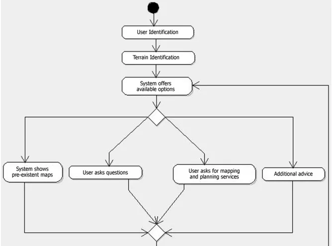
Figure 4 - Activity diagram describing the modes of interaction between a user and expert system during a typical run.
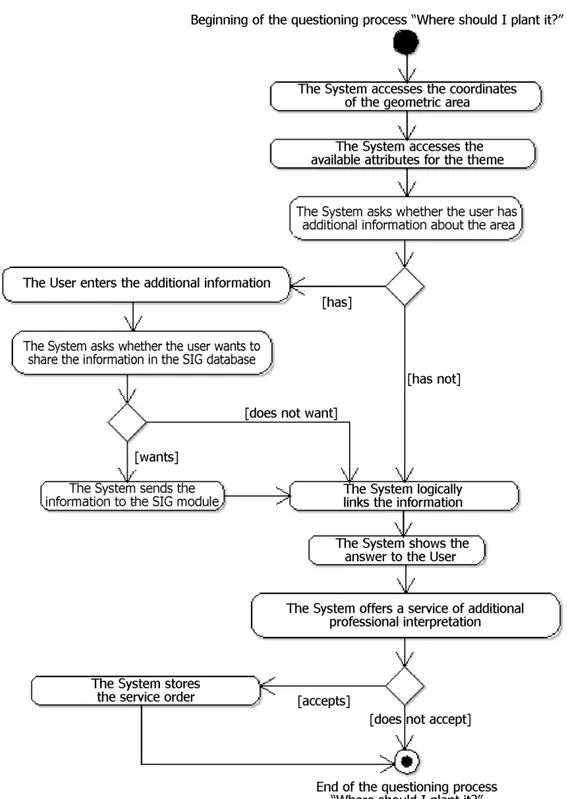
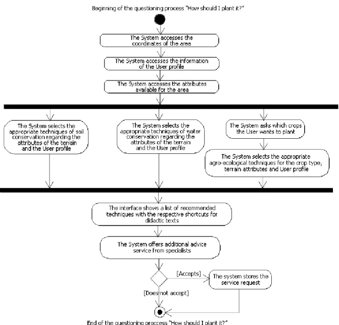
The activity diagrams in Figures 5, 6 and 7 show the flow of procedures that are involved in each use case (what, where and how to plant). It is important to note that the user is able to enter new (cartographic or point) data to support the decision-making process. The variables that are entered voluntarily may also be shared over the network to improve the structure of the information about the area. Entering data is a key characteristic to adapt the system to a multiple-scale function.
the optimal (optimized) design of productive land use (MARTINS JUNIOR et al., 2006).
Figure 5 - Diagram of activities showing the initial logic modeling of the explicit reasoning that is encompassed in the question “what should I plant?”.
this knowledge can be properly translated into the formal logical structure of a computational database.
Figure 6 - Activity diagram showing the initial logic modeling of the explicit reasoning that is
Figure 7 - Activity diagram showing the initial logic modeling of the explicit reasoning that is encompassed in the question “how do I plant it?”.
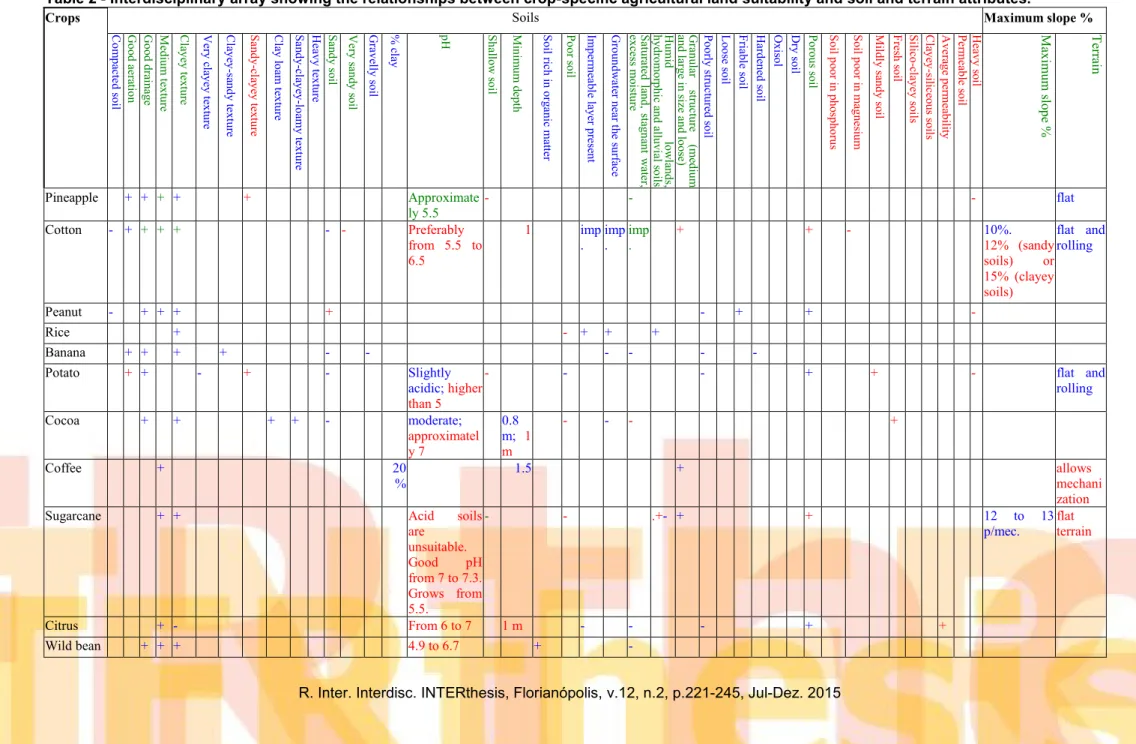
To address this epistemological challenge, a pilot systematization of agricultural land suitability criteria was performed based on the agronomic advice compilation studies of Lainetti and Brito (1986) and Queiroz et al. (1980). The goals were to identify the attributes that are most commonly associated with various crops and to assess the effect of the environmental attribute on the agricultural suitability of each species. The information systematization process followed the method of interdisciplinary logic arrays of MARTINS JUNIOR et al. (2006) and is shown in Table 2.
scientific approach to agricultural land suitability at a micro-scale would require gathering technical publications that are specific for each crop. Thus, Table 2 only shows the feasibility of building an information structure that combines data on agricultural land suitability that are currently scattered throughout several studies and agronomic newsletters. Integrating data about the suitability of each crop would enable computer comparisons to identify which crops would be best suited for production based on the terrain characteristics in microscale simulations.
During either knowledge modeling or its evaluation and refinement cycle, the following questions about the effectiveness of the decision-making support should be considered at the various scales of approach and user profiles (VASCONCELOS et al. 2005, p.14). [1] What legitimate action can be taken in a given circumstance that
is in the economic interest and is consistent with the environmental aspects? [2] How much environmental impact should be tolerated; i.e., in extreme cases, such as extensive and/or intensive farming, what is the limit when seeking to cover large areas with farming projects? [3] What alternatives are available when agricultural interests are confronted by environmental constraints? [4] What mitigations and preventive technical solutions are available, and at what cost, to ensure that the economic-ecological approach is respected? [5] What is prohibited by law?
An information feedback system in which users can respond about whether they agree or disagree with the advice (and why) may be made available to assess the efficacy of the system. Another form of interaction is to include additional questions for the users, which ask whether they intend to follow the advice or not and why.
Table 2 - Interdisciplinary array showing the relationships between crop-specific agricultural land suitability and soil and terrain attributes.
Crops Soils Maximum slope %
C o m p ac te d so il G o o d a er at io n G o o d d ra in ag e M ed iu m te x tu re C la y ey te x tu re V er y c la y ey te x tu re C la y ey -sa n d y te x tu re S an d y -c la y ey te x tu re C la y lo am te x tu re S an d y -c la y ey -lo amy te x tu re H ea v y te x tu re S an d y so il V er y s an d y s o il G ra v el ly s o il % cl ay pH S h al lo w s o il M in im u m d ep th S o il ric h in o rg an ic mat te r P o o r s o il Imp er me ab le la y er p re se n t G ro u n d w at er n ea r t h e su rf ac e S at u ra te d l an d , st ag n an t w at er , ex ce ss m o ist u re H u mi d lo w la n d s, h y d ro m o rp h ic a n d a llu v ia l s o ils G ra n u la r st ru ct u re (me d iu m an d la rg e in si ze a n d lo o se ) P o o rly st ru ct u re d s o il Lo o se so il F ria b le so il H ar d en ed s o il O x is o l D ry so il P o ro u s s o il S o il p o o r i n p h o sp h o ru s S o il p o o r i n ma g n esi u m M ild ly sa n d y so il F re sh s o il S ili co -cl ay ey so ils C la y ey -si lic eo u s s o ils A v er ag e p er mea b ili ty P er mea b le s o il H ea v y s o il M ax imu m slo p e % Terra in
Pineapple + + + + + Approximate ly 5.5
- - - flat
Cotton - + + + + - - Preferably from 5.5 to 6.5
1 imp
. imp .
imp .
+ + - 10%. 12% (sandy soils) or 15% (clayey soils)
flat and rolling
Peanut - + + + + - + + - Rice + - + + + Banana + + + + - - - - - -
Potato + + - + - Slightly acidic; higher than 5
- - - + + - flat and rolling
Cocoa + + + + - moderate; approximatel y 7
0.8 m; 1 m
- - - +
Coffee + 20 %
1.5 + allows mechani zation Sugarcane + + Acid soils
are unsuitable.
Good pH
from 7 to 7.3. Grows from 5.5.
- - .+- + + 12 to 13 p/mec.
flat terrain
Citrus + - From 6 to 7 1 m - - - + +
Crops Soils Maximum slope % C o m p ac te d so il G o o d a er at io n G o o d d ra in ag e M ed iu m te x tu re C la y ey te x tu re V er y c la y ey te x tu re C la y ey -sa n d y te x tu re S an d y -c la y ey te x tu re C la y lo am te x tu re S an d y -c la y ey -lo amy te x tu re H ea v y te x tu re S an d y so il V er y s an d y s o il G ra v el ly s o il % cl ay pH S h al lo w s o il M in im u m d ep th S o il ric h in o rg an ic mat te r P o o r s o il Imp er me ab le la y er p re se n t G ro u n d w at er n ea r t h e su rf ac e S at u ra te d l an d , st ag n an t w at er , ex ce ss m o ist u re H u mi d lo w la n d s, h y d ro m o rp h ic a n d a llu v ia l s o ils G ra n u la r st ru ct u re (me d iu m an d la rg e in si ze a n d lo o se ) P o o rly st ru ct u re d s o il Lo o se so il F ria b le so il H ar d en ed s o il O x is o l D ry so il P o ro u s s o il S o il p o o r i n p h o sp h o ru s S o il p o o r i n ma g n esi u m M ild ly sa n d y so il F re sh s o il S ili co -cl ay ey so ils C la y ey -si lic eo u s s o ils A v er ag e p er mea b ili ty P er mea b le s o il H ea v y s o il M ax imu m slo p e % Terra in
Cowpea + + + from 5.5 to 6.5
- + - + +
Common bean
+ + + + from 5.6 to 6.8
+ -
Castor bean
+ + - - 15 to 40 %
Near neutral; from 6 to 7
- - - + - + + + 12%
Cassava - + + +
-
-
imp .
+ + + + i m p.
10% flat
Corn + + + + + - + - + + 10 to 12 Soybean + + 1 to
2
+ 8 to 10
Sorghum + + + - - 30 to 35 %
1 - 12 to 13
Wheat + + - - 2 - + 12 Rubber
tree
+ + + + - - -
Legend:
+ Characteristic favorable to the crop - Characteristic adverse to the crop
Agroclimatic Atlas [Atlas agroclimatológico] (QUEIROZ et al., 1980)
Crop guide from A to Z [Guia de culturas de A a Z] (LAINETTI and BRITO, 1986)
4 CONCLUSIONS
The knowledge-modeling procedures indicated the possibility of developing a formal information structure and algorithms to help interpret agricultural land suitability and land planning at multiple scales. SDSS pilot projects have already been tested for agroclimatic crop selection (“what to plant”; HARTATI and SITANGGANG, 2010), generic zoning for agricultural land suitability (“where to plant”) at the macroscale (MOURA, 2007) and the microscale (DELARMELINDA et al., 2014), and agricultural management procedures (“how to plant”; KARMAKAR et al., 2007). However, the information structure that is proposed in this study suggests
the usefulness of integrating agricultural land suitability information, techniques and methods in the three approaches that were outlined in an ever broader knowledge architecture.
The main benefit of the SDSS model is to provide support for land planning decision-making to farmers and drainage basin managers. Advice may be useful in regions in which a new farming activity is about to start as well as in regions that are already under effective land use (BAJA et al., 2001).
Under a broad interpretation, the SDSS provides a set of geo-environmental logic commands that enable the selection of various land use solutions to maintain the overall stability of the natural systems, cause minimal irreversibility in any subsystem and thus meet adequate economic productivity goals (PEREIRA, 2002, p. 13-17; MARTINS JUNIOR et al., 2005; PEREIRA et al., 2006). The logical results that are based on the spatial attributes generate the recommendations that are provided to users.
The system is also an effective instrument for agricultural and environmental education because it proposes environmentally sustainable alternatives to users and explains the economic rationale for the proposals. Thus, the users are encouraged to take a more coherent stance on their land use activities that incorporates the correct environmental variables and the corresponding implications for economic productivity into their decisions. It is important to note that the system provides a nucleus of coordination between farmers, drainage basin managers and environmental managers by combining the three land planning approaches into an integrated ecological and economic rationale as was advocated by Pereira et al. (2006).
the SDSSs that were modeled in this study have the following limitations:
- difficulties in modeling tacit agricultural knowledge and performing generalizations based on this knowledge;
- the need for specialized information at a detailed scale to provide adequate guidance;
- limitations on the technical ability of users to enter information, understand the guidelines, and apply them effectively; and
- difficulties in accessing computers and the Internet in rural areas.
ACKNOWLEDGMENTS
CIÊNCIA DA INFORMAÇÃO E APTIDÃO AGRÍCOLA: ABORDAGENS INTERESCALARES PARA PLANEJAMENTO DE USO DA TERRA
Resumo:
As inovações técnicas e metodológicas de programação, compartilhamento em rede, análise de sistema de informação e sistemas de informação geográfica (SIG) permitem a representação, armazenamento, tratamento e disseminação de informações que antes não se havia disponíveis para diversos atores interessados. Partindo desse contexto, apresenta-se proposta de modelagem conceitual sobre o uso integrado das metodologias de Aptidão Agrícola para o desenvolvimento de sistemas de auxílio à decisão sobre uso da terra, auferidas por meio de metodologias da Ciência da Informação. São estruturados diagramas de modelagem de conhecimento por meio dos métodos CommonKADS e Unified Modeling Language (UML), para simular o processamento de perguntas básicas de um produtor rural, tais como “O que plantar?”, “Onde plantar?”, “Como plantar?”. Por fim, é apresentado uma matriz interdisciplinar explicitando a relação entre a aptidão Agrícola por cultivar com atributos de solo e relevo, para auxílio à decisão em escala de detalhe. O sistema proposto afigura-se um eficaz instrumento de orientação e educação agropecuária e ambiental, por demonstrar alternativas ecologicamente sustentáveis ao usuário e explicar a justificativa econômica para tais propostas. Palavras-chave: Agronomia. Sistemas de Informação Geográfica. Ciência da Informação. Sistemas de Auxílio à Decisão. Meio Ambiente.
CIÊNCIA DE LA INFORMACIÓN Y APTITUD AGRÍCOLA: ENFOQUES INTER-ESCALARES PARA PLANIFICACIÓN DEL USO DE LA TIERRA
Resumen:
Las innovaciones técnicas e metodológicas de programación, compartición en red, análisis de sistemas de informaciones e sistemas de información geográfica (SIG) permiten la representación, almacenamiento, tratamiento y diseminación de informaciones que anteriormente no estaban disponibles para los diversos actores interesados. A partir de este contexto, se presenta una propuesta de modelización conceptual acerca del uso integrado de las metodologías de aptitud agrícola para la implementación de sistemas de soporte a la decisión acerca del uso del suelo, por intermedio de metodologías de la Ciencia de la Información. Se estructuran diagramas de modelaje del conocimiento por los métodos CommonKADS y Unified Modeling Language (UML) para simular el tratamiento de cuestiones básicas de un productor rural, tales como “¿Qué puedo plantar?”, “¿Dónde plantar?”, “¿Cómo plantar?” Por último, una matriz interdisciplinaria es presentada, clarificando las relaciones entre aptitud agrícola con atributos del suelo y del relieve, de modo a auxiliar en la tomada de decisiones en escala de detalles. Lo sistema propuesto puede ser una instrumento eficaz para la orientación y educación agrícola y ambiental, por demonstrar alternativas ecológicamente sostenibles, mientras explana las justificación económica para tales alternativas.
Palabras clave: Agronomía, Sistemas de Información Geográfica, Ciencia de la Información, Sistemas de Soporte a la Decisión, Medio Ambiente
REFERENCES
AKINCI, H.; ÖZALP, A. Y.; TURGUT, B. Agricultural land use suitability analysis using GIS and AHP technique. Computers and electronics in agriculture, 97, 71-82. 2013.
ASSAD, E. D., MARTINS, S. C., BELTRÃO, N. E.M.; PINTO, H. S. Impactos das mudanças climáticas no zoneamento agrícola de risco climático para o cultivo de algodão no Brasil.Pesquisa Agropecuária Brasileira,48(1), 1-8. 2013.
BAJA, S., CHAPMAN, D.M., DRAGOVICH, D. A conceptual model for assessing agricultural land suitability at a catchment level using a continuous approach in GIS. Geospatial Information and Agriculture, The Regional Institute Ltd. 2001.
BOLFE, É. L., VICENTE, L. E., SPINELLI-ARAÚJO, L., VICTORIA, D.C, TÔSTO, S. G., TORRESAN, F., QUARTAROLI, C.F.; FURTADO, A.L.S.; MARTINS, M. A. M. Banco de Dados Geoespaciais do Macrozoneamento Ecológico-Econômico do Estado do Maranhão. In: SIMPÓSIO BRASILEIRO DE SENSORIAMENTO REMOTO, 17., 2015, João Pessoa. Anais... São José dos Campos: INPE, 2015.
DELARMELINDA, E. A., WADT, P. G. S., ANJOS, L. H. C., MASUTTI, C. S. M., SILVA, Ê. F., SILVA, M. B., COELHO, R.M.; SILVA, L.M.; SHIMIZU, S.H.; COUTO, W. H. Aplicação de sistemas de avaliação da aptidão agrícola das terras em solos do Estado do Acre, Amazônia. Biota Amazônia, 4(2): 87-95. 2014.
FAISAL, C.M.N.; AWAN, M.S.A.; ARSHAD, M.S. Knowledge Management: A Particle Approach to Design Knowledge based Portal Using CommonKADS. Lap Lambert, 2011. 60p.
GINSBERG, Matt - Essentials of Artificial Inteligence -Morgan Kaufmann Publihsers – USA, 1993.
HARTATI, S.; SITANGGANG, I. S. A fuzzy based decision support system for evaluating land suitability and selecting crops. Journal of Computer Sciences. 6(4):417-424, 2010
KARMAKAR, S.; LAGUË, C.; AGNEW, J.; LANDRY, H. Integrated decision support system (DSS) for manure management: A review and perspective. Computers and Electronics in Agriculture, 57(2), 190-201. 2007.
LEPSCH, I. F.; BELLINAZZI JR., R.; BERTOLINI, D.; ESPÍNDOLA, Carlos Roberto. Manual para levantamento utilitário do meio físico e classificação de terras no sistema de capacidade de uso. 4a aproximação. Campinas: SBCS, 1991. 175p.
LUPPI, A.S.L.; SANTOS, A.R.; EUGÊNIO, F.C.; BRAGANÇA, R.; PELUZIO, J.B.E.; DALFI, R.L. SILVA, R.G. Metodologia para classificação de zoneamento
agroclimatológico. Revista Brasileira de Climatologia. 10 (15): 80-97. Jul/Dez 2014
MANZATTO, C. V.; ASSAD, E. D.; BACCA, J. F. M.; ZARONI, M. J.; PEREIRA, S. E. M. Zoneamento agroecológico da cana-de-açúcar.Rio de Janeiro: Embrapa Solos. 2009
MARQUES, F.S.M.; MARTINS JUNIOR, P.P.; VASCONCELOS, V.V.; NOVAES, L.A.d`A. Proposição Metodológica para a Cartografia de Solos e Aptidão Agrícola: Estudo de Caso para a Bacia do Rio Paracatu. Revista Brasileira de Geografia Física, Vol. 5, No 1 (2012) 01-17.
MARTINS JUNIOR, P.P.; ROSA, S.A.G., CANTISANO, M.A.M., GOMES, L.A. M.. Zoneamentos Econômicos de Bacias Hidrográficas - Importância Ecológica. Revista ECEN - Economia & Energia, Ano XII. No 71, Dezembro, 2008 - Janeiro, 2009.
MARTINS JUNIOR, P.P. et al. Projeto ACEE – Arquitetura de Conhecimentos em Ecologia-Economia. MCT/CNPq 2005-2007. Relatório Final em 2007.
MARTINS JUNIOR, P.P. et al.. Projeto CRHA - Conservação de Recursos Hídricos no âmbito de Gestão Agrícola de Bacias Hidrográficas.
MCT/FINEP/CT-HIDRO 2002-2006. Relatório Final em 2006.
MARTINS JUNIOR, P.P. et al. Projeto SACD - Sistemas de Arquitetura de
Conhecimentos e de Auxílio à Decisão na Gestão Geo-Ambiental e Econômica de Bacias Hidrográficas e Propriedades Rurais. Fapemig (2010-2011). Relatório Final em 2012.
MOURA, L. C. (2007). A ocupação espaçotemporal dos cafezais no município de Machado, no Sul de Minas: a relação entre aptidão agrícola da terra e seu uso na atividade cafeeira. Tese (Doutorado). Universidade Federal de Lavras. Lavras-MG. 117p.
OZAKI, V. A. O papel do seguro na gestão do risco agrícola e os empecilhos para o seu desenvolvimento.Revista Brasileira de Risco e Seguro, 2(4), 75-92. 2007.
PEREIRA, L. C. Aptidão Agrícola das terras e sensibilidade ambiental: proposta metodológica. Tese de Doutorado. Faculdade de Engenharia Agrícola.
Universidade Estadual de Campinas (SP). 2002. 135p.
PEREIRA, L.C.; SILVEIRA, M.A.; LOBARDI NETO, F. Agroecologia e Aptidão de Terras: as bases científicas para uma agricultura sustentável. Embrapa Meio Ambiente: Jaguariuna, 2006, 5p.
PEREIRA, L.C.; LOMBARDI NETO, F. Avaliação da aptidão agrícola das terras: proposta metodológica. Jaguariúna: Embrapa Meio Ambiente, Documentos, nº 43. 2004. ISSN 1516-4691
PORTO, Rodrigo Amorim. Gestão do conhecimento: os desafios de explicitar conhecimentos técnicos. 2011. 55 f., il. Monografia (Bacharelado em
Administração)—Universidade de Brasília, Brasília, 2011.
QUEIROZ, R., SOUZA, A.G., SANTANA, D.P., ANTUNES, F.Z, FONTES, M. (coord.) – Zoneamento Agroclimatológico de Minas Gerais – Governo de Minas Gerais, Secretaria de Agricultura, Belo Horizonte, 1980.
RAMALHO FILHO, A.; BEEK, K. J. Sistema de avaliação da aptidão agrícola das terras. 3.ed. Rio de Janeiro: EMBRAPA-CNPS, 1995. 65p.
SCHNEIDER, L. M., ROLIM, G. D. S., SOBIERAJSKI, G. D. R., PRELA-PANTANO, A.; PERDONÁ, M. J. Zoneamento agroclimático de nogueira-macadâmia para o Brasil. Revista Brasileira de Fruticultura, 34, 515-524. 2012.
SEIDL, M., SCHOLZ, M., HUEMER, C.; KAPPEL, G..UML@ Classroom: An Introduction to Object-Oriented Modeling. Springer. 2015. 206 pages
Agrícolas - XVI SIMPÓSIO BRASILEIRO DE RECURSOS HÍDRICOS, Anais... 2005. 20 p.
WOLLMANN, C. A.; GALVANI, E.. Zoneamento agroclimático: linhas de pesquisa e caracterização teórica-conceitual.Revista Sociedade & Natureza,
Uberlândia,25(1). 2013.
WOLLMANN, C. A.; GALVANI, E. Zoneamento Agroclimático. Buqui Livros Digitais. 2014. 149p.
Article: