Abstract—In large parking areas such as those at mega shopping malls or stadiums, drivers always have difficulty to find vacant car-park lots especially during peak periods or when the car-parking lots are almost full. A solution to reduce the drivers’ searching time for vacant car-park lots will greatly save time, reduce cost and improve the traffic flow in the car park areas. In this paper, a research project which was developed to acquire car-park occupancy information using integrated approach of image processing algorithms is presented. Motivation for developing this system came from the fact that minimum cost is involved because image processing technique is used rather than sensor-based techniques. Security surveillance cameras which are readily available in most car parks can be used to acquire the images of the car park. This solution is much cost effective than installing sensor on each parking lot. This project is called as Car-Park Occupancy Information System (COINS), and it was tested using simulation model and also in real-case scenarios.
Keywords—Image processing, car park occupancy, object detection, information system.
I. INTRODUCTION
t is very common to have huge crowds in places like mega shopping malls and stadiums during peak periods. In shopping malls, discounts and season sales offered by merchants can attract thousands of customers to come during the sale periods. Most of the customers travel to the shopping malls with their own vehicles and it is not surprising to see that car parks are always full during these periods. However, research into drivers' parking behavior indicated that this does not seem to stop many drivers from queuing at their favorite car park for significant periods [1]. New generation information services have been proposed or developed to replace traditional "Full/Spaces" sign at the entrance. These come in the form of parking information via mobile phones, personal digital assistants (PDAs), RDS-TMC, navigation systems and Urban Traffic Management and Control (UTMC) [1]. Parking guidance system such as the one developed at Shinjuku, Japan [2] and Tapiola, Finland [3] are examples of systems developed to guide drivers in finding vacant car parks.
Manuscript received 23 November 2007.
D.B.L. Bong is a Lecturer with Faculty of Engineering, Universiti Malaysia Sarawak, 94300 Kota Samarahan, Sarawak, Malaysia. (phone: 60-82-583313; fax: 60-82-583409; email: [email protected]).
K.C. Ting is a Postgraduate Student with Faculty of Engineering, Universiti Malaysia Sarawak, 94300 Kota Samarahan, Sarawak, Malaysia.
K.C. Lai is a Postgraduate Student with Faculty of Engineering, Universiti Malaysia Sarawak, 94300 Kota Samarahan, Sarawak, Malaysia.
There are mainly four categories of car park guidance systems using different technologies - counter-based, wired sensor-based, wireless sensor-based and image-based. Counter-based systems use sensors to count the number of vehicles entering and exit a car park area. This can be gate-arm counters and induction loop detectors located at the entrances and exits [3]. This system can give information on the total number of vacant lots in a closed car park area, but does not help much in guiding the driver to the exact location of the vacant lots.
Wired sensor-based system, on the other hand, is using detection sensors such as ultrasonic sensors which are installed at each parking lot. These sensors are wired to a central control unit that store and manage the parking occupancy information. This information is then relayed to display panels at strategic locations in the car park. The display panels provide information, direction and guide the drivers to vacant parking lots. Yu and Liu [4] used vortex berth detector in the parking guidance system. MCU is used to process the sensor signal and parking information is transmitted through CAN bus interface to the control centre. Wolff et al used magnetic field sensors and wired-based concept to test on their simulation model [5]. One shortcoming of the wired sensor systems is long and complicated wiring is required from parking lots to the central control unit. Also, the cost for developing this system is high because large amount of sensor units are required and long distance of wiring from parking lots to the control centre.
With the advancement of wireless technologies, wireless-based methods have been employed in parking guidance systems. Wireless sensors nodes are deployed and each parking lot is equipped with one node. Tang, Zheng and Cao [6] developed such a system using Crossbow Mote products and the extended Crossbow XMesh network architecture. The sensor board is equipped with the sensors of light, temperature, acoustic and a sounder. Benson et al used DSYS25z sensing nodes which is an ATMega 128L micro-controller based system with RF transceiver and antenna. Wang, Zhou and Li adopted HMC1021 anisotropic magneto-resistive magnetic field sensor from Honeywell together with microprocessor and transceiver for the same purpose [7]. There are also other researches using wireless-based methods such as in [8] and [9]. Examples of start-up companies that are actively working in this field are ParkingCarma [10], Streetline Networks [11] and vehicleSense [12]. University of California at Berkeley [13] and EPFL Switzerland [14] carried out
Integrated Approach in the Design of Car Park
Occupancy Information System (COINS)
D.B.L. Bong, K.C. Ting and K.C. Lai
I
similar projects using wireless sensor nodes. In using wireless technologies, disadvantage in employing sensor at each parking lot is still present and can be very costly as each sensing unit is usually attached with a processing unit and a transceiver.
The last category of car park guidance systems use image-based techniques or some people call it as video sensor techniques. There are arguments concerning the viability of using image-based techniques. According to [6], the disadvantages are video sensor is energetically expensive and video sensor can generate large amount of data which can be difficult to transmit in a wireless network. The authors, however, believe that suitable places to have image-based car park guidance system such as shopping malls already have security surveillance camera in place. Therefore, to develop an image-based guidance system, one just need to tap on the existing surveillance camera, convert the image to digital video format and perform image processing on the video. It doesn't incur much cost as existing surveillance cameras are used. Usually the camera is connected to a central monitoring system using wired protocol and thus the need to have wireless network is avoided.
Image-based techniques are deployed widely in areas such as security surveillance [15][16][17][18], motion tracking [19][20] and traffic control [21]. Images can also be constructed by laser scan [22] but this usually comes with a moving autonomous vehicle. A few existing studies also focused on the applications of car parking system using video sensor technologies as in [23] but not much information is released. Funck, Mohler and Oertel proposed a system to estimate the occupancy of a car-park using a single image of a single camera. The algorithm works by constructing a reference image of the empty car-park given the input image using Principal Component Analysis, compare both images and calculate the occupancy estimate as the ratio of vehicle pixel area to car-park pixel area [24]. However, issues such as initial system setup, initialization and scope of the project are not properly detailed in the paper.
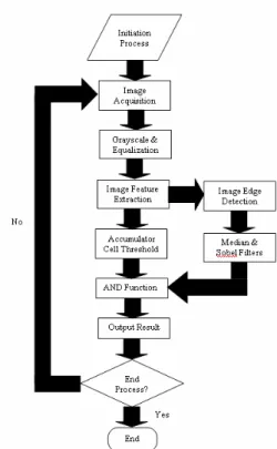
In this paper, the authors focus on using integrated approach of image processing methods to obtain car park occupancy information. The integrated approach covers initial setup and normal running operation of the system. Image processing techniques such as seeding, boundary search, object detection and edge detection are integrated to form a complete structure of the system. The system has been named as Car Park Occupancy Information System (hereafter called as “COINS”). Overview of the system, setup and initialization methods are presented in Section 2. Algorithm and methodologies used are explained in Section 3. Experiment and test result are presented in Section 4 and Section 5 concludes the paper.
II. SYSTEM OVERVIEW &SETUP
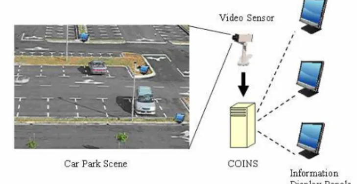
An overview of COINS is illustrated in Fig. 1. A car park scene is the input acquired by image or video sensor. This acquisition device is connected to a processing unit that runs Matlab program and Real Time Workshop. The images are
processed in the developed algorithms which used integrated approach. Result of the processing is output to display devices such as a computer monitor. In advanced implementation, display panels which are located at strategic locations in the car park are used. Various methods can be used to transmit the result either using wired or wireless system to the panels.
Fig. 1. COINS system overview.
COINS is developed based on single source input. A CCTV, webcam or any video sensors can be used to acquire digital images or video. Additional analog-to-digital converter is needed if analog video sensors are used. The digital video or images is processed using Matlab program with Real-Time Workshop. The camera is positioned in facing the front or rear view of parking lots, acquiring a fixed scene all the time. The height of the camera must be enough to obtain a clear, unobstructed top view of the parking lots. In our system, the value of approximately six times the height of vehicle is used. Video clip running at 2 frames per second is good enough for the project. Higher frame rate is not recommended unless high speed processing unit is used. Digital images were extracted out from the video clip for image processing.
Acquired images or video is processed in the developed algorithm and result is displayed on display devices. For COINS, computer monitor is used for display. However, in advanced implementation, occupancy information can be transmitted wirelessly to display panels that are located at strategic locations in the car park. Drivers will be able to find a vacant parking lot based on the information displayed in the panels.
There are two test platforms to gauge the performance of COINS. The first one used a simulation model where miniature car park is created using simple stationery. Small miniature car models of equal sizes are used in the simulation. A 320x240 pixel resolution webcam acts as video sensor to acquire real time video of the simulation model. Video acquisition rate is set at 2 frames per second. The system runs on Matlab program and uses Real Time Workshop. Result from COINS processing is displayed in real time on the computer monitor.
not expected to perform under low image luminance such as night time, unless street lighting is available.
III. SYSTEM INITIALIZATION
In this project, initialization is separated into two parts. First, a one-time manual seeding procedure is performed where using unedited image (with zero car present in the car park area), a yellow ‘seed’ is planted on each parking lot manually using any image editing software such as MS Paint. The purpose of this procedure is to get COINS algorithm to automatically identify location of every parking lot in the image. Distinct pure yellow seeds are chosen to differentiate them from any color that might present in the image. Fig. 2 is an example of unedited image and Fig. 3 is the image with seed at each parking lot. It should be noted that the lines separating the parking lots have to be visible, clear and unobstructed in the initialization process. In the event that the lines of the parking lots are not clear, manual redrawing of the lines can be done to solve this problem. Performing some manual tasks at this stage will not degrade efficiency of the system as the whole procedure of initialization is only performed once to find out the exact coordinates of all parking lots. The camera is assumed to be in a fixed position and facing a fixed direction all the time.
Fig. 2. Original image with zero occupied parking lot.
Fig. 3. Image (from Fig. 2) edited using manual seeding procedure.
The algorithm for initialization process will begin with the program searching for yellow seeds in the initial image by detecting the RGB values of yellow. Detected yellow seeds are then eroded into single pixels. From the single pixels, the program embarks on a local boundary search to identify the
locations of the boundaries of all parking lots. The boundary search used directions of 4-adjacency and detect white boundary lines of the parking lots. 4-adjacency is used because the camera is facing front or rear view of the vehicles, thus the boundary lines of the parking lot are almost perpendicular to the 4-adjacency directions. Detected white lines during local boundary search are taken as the lines separating adjacent parking lots. For each parking lot, 4 white lines will be detected, one at each side of the 4-adjacency direction. With the four detected lines, a box representing parking lot can be drawn and intersections of the lines are the four corners of the box. Spatial coordinates of the corners are stored in a database which is a comma separated value (.csv) file. With this information, exact location of parking lots in the image is known. Illustration of the boundary search is shown in Fig. 4. Fig. 5 shows the overall flow diagram of the initialization process. The initialization procedure and process are performed once only at the early stage of system setup.
Fig. 4. Illustration on boundary search.
Fig. 5. Flow diagram for initialization.
IV. INTEGRATED IMAGE PROCESSING METHODOLOGIES
occupancy based on current images. In normal operating condition, integrated image processing methodologies are used to determine occupancy of parking lots. Integrated approach is used as it gives better detection rate and lower false acceptance rate (FAR) and false rejection rate (FRR). The acquired images are converted to gray images first and histogram equalized. Then, a bi-stream detection approach is used which consists of mainly two main streams. The first is on image feature extraction to detect the presence of vehicle or object in parking lots. Threshold is set to detect the presence of pixels that are below a certain value. This purpose is to differentiate pixels that come from the vehicle (lower than the threshold value) and from the road which implies unoccupied lot. Unoccupied lots only have gray pixels of the road which values are above the threshold. This threshold value is obtained by getting the average value of the road pixels under different illumination conditions and adjusted to represent a fair amount (at least 90%) of unoccupied lot. The result from the first stream gives information on the presence of object or vehicle in the parking lots. The second stream works on eliminating false detection due to the presence of shadow of vehicles. Images of the vehicles in the car park are captured from the front or rear view. For an occupied lot, it is possible that shadow of the vehicle being projected onto the adjacent parking lot if the sunlight comes from the side. The projected shadow is detected as object from the first stream image processing and could cause a false detection. This, however, can be avoided by having the second stream works as a filter to give a null vote if shadow is detected. This second stream uses median filtering and Sobel edge detection. Each stream in the integrated approach casts a vote to the AND function at the end. Final result is based on the votes in the AND function. Fig. 6 shows the process flow of COINS and the two main streams.
A. Vehicle Detection
In vehicle detection stream, the aim is to detect the presence of a car or vehicle in a particular parking lot. Pixel detection is used to detect the presence of a vehicle in each parking lot. Bit-7 in the grayscale is used as the threshold to differentiate pixels from the vehicle and from unoccupied lot. A value of 0 in bit-7 shows the presence of vehicle component while a value of 1 shows component of unoccupied lot. Complement of this value is used to make the value of 1 representing the presence of vehicle component. This can be expressed as
g(x,y) = 1 – (bit-7) (1)
Fig. 6. Flow diagram for integrated approach of COINS.
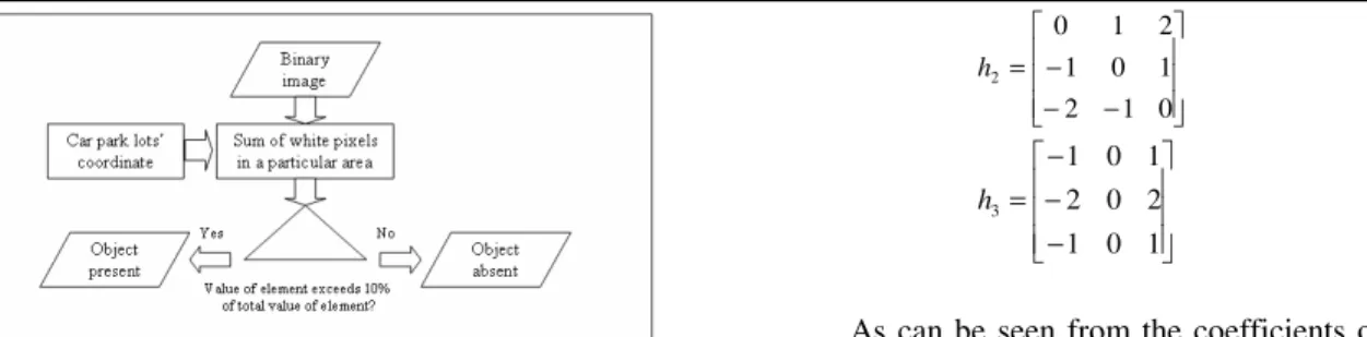
An accumulator agent is used to add up all the pixels’ values. Result of this accumulator agent is used to determine the presence of a vehicle in a particular parking lot. This is done by subjecting the result to a threshold value, T1 as
follows:
1
1
1
if
g(x,y) > T
'( , )
0 if
g(x,y)
T
g x y
=
≤
(2)The value T1 represents the threshold that separates between
object and background. It is common that undesirable noise presents in an image and contributed to the result of accumulator agent. With the threshold T1, vehicle detection is
more accurate and eliminated false detection due to the presence of noise. The value T1 is determined by many trials
and testing done on separately cropped parking lots. From the testing, it is found that optimum value of T1 is around 10% of
the total pixels of a particular parking lot. If the result of accumulator agent exceeds T1, the system will recognize that
Fig. 7. Vehicle detection algorithm.
Having a vehicle detection algorithm based on gray level segmentation, accumulator agents and threshold is not good enough as a major drawback of this algorithm is the false detection of projected shadow on adjacent parking lot. The projected shadow, although inconsistent, but most of the time can satisfy the threshold requirement and thus gives a false detection result.
B. Edge Detection Using Sobel Operators
The second stream of algorithm is used to eliminate shadow effect. Median filtering and edge detection are used in this stream. Median filtering is used as it is popular for eliminating random noise and provides excellent noise-reduction capabilities [25]. Median filter is performed first to reduce the presence of edges that come from random noise. This is important to as a pre-processing step for edge detection.
A number of operators can be used for edge detection such as Roberts, Prewitt and Sobel operators. In our implementation, Sobel operators are used because they have slightly superior noise-suppression characteristics [25]. Fig. 8 shows the result of applying Sobel operators.
Fig. 8. Result of Sobel edge detection.
Sobel operators are used as complement to the shortcoming that exists in vehicle detection. This is a gradient operator that approximates first order partial derivatives of a digital image. First order derivatives are used to detect edges in an image. The main purpose of edge detection used in this system is that it separates the shadow and object. More edge information is found on object compare to shadow [26]. Equations (3) to (5) show the coefficients in the masks of Sobel operators.
− − − =
1 2 1
0 0 0
1 2 1
1
h (3)
− −
− =
0 1 2
1 0 1
2 1 0
2
h (4)
− − − =
1 0 1
2 0 2
1 0 1
3
h (5)
As can be seen from the coefficients of Sobel operators, it uses a weight of 2 in the center coefficient. A weight value of 2 is used to achieve some smoothing by giving more importance to the center point [25]. If we apply h1 on a 3x3
region of an image (as shown in Fig. 9), a vector Gx in the
direction of x can be produced.
Gx = (z7 + 2z8 + z9) – (z1 + 2z2 + z3) (6)
Fig. 9. A 3x3 region of an image[25].
To obtain vector Gy, we use h3 on the region of image.
Gy = (z3 + 2z6 + z9) – (z1 + 2z4 + z7) (7)
Vector Gx and Gy form as the gradient components and the
gradient magnitude, G, can be approximated as
G = [Gx2 + Gy2]1/2 |Gx| + |Gy| (8)
The magnitude G gives the maximum rate of increase of image g(x,y) for horizontal and vertical edges. For diagonal direction, operator h2 can be used.
Fig. 10 and 11 show the images before and after the Sobel edge detection. After edge function, the system will accumulate detected edge pixels in every parking lot and subject the result of this summation to another threshold value, T2, which separates between shadow and object. Value of T2
comes from repeated testing and optimum value is about 5% of total pixels of parking lot. The edge of shadow usually contributed to the summation value but rarely exceed 5% of total pixels of parking lot. This is because shadow presents a uniform or smooth transition of shades of grays which does not constitute an edge. If the percentage of total white pixels exceeds 5% of total pixels, the system will recognize this particular parking lot consists of car or object, and vice versa for otherwise.
Fig. 10. Image with one parking lot occupied.
Fig. 11. Result of Sobel edge detection performed on Fig. 10.
C. Voting At The AND Function
Each of the result from vehicle detection and Sobel edge detection constitutes a vote which is then subject to an AND function. The AND Function is used to give a final result based on the votes of the two main streams. Table 1 shows the AND Function used in this project.
TABLE I THE AND FUNCTION
Vehicle detection Edge Detection Output
0 0 0
0 1 0
1 0 0
1 1 1
From Table 1, notice that the final output shows the particular parking lot is occupied with vehicle only when both the object and edge detections give positive outputs. With the absence of a positive output from either the object or edge detection, that particular parking lot is considered empty.
V. EXPERIMENT &TEST RESULTS
This system had been tested using (a) a car park simulation model and (b) real car park scenario. The output of this project uses color representation for car park lots’ availability identification and display on a computer monitor. Indicator points are display on the screen with each indicator representing one parking lot. The orientation of the rows of the indicators is following closely on the orientation of the parking lots. This is obviously shown in Fig. 14, Table II and Table III. For yellow indicators, they signify vacant parking lots while for purple indicators, they are occupied lots.
A. Simulation Model
Simulation model has been created for initial test to verify workability of the program. This is done prior to real-case scenario test. A low budget simulation model as shown in Fig. 12 is built. Small model cars are used to test on the reliability of the car park information system. The system was set up using a web camera with 320x240 pixel resolution facing directly to the front view of the car park in the simulation model. A real time running test is performed and three model cars are used. Simulation is based on design-of-experiment methodology where different scenarios of one, two or three cars parking and leaving are performed. Fig. 13 shows a snapshot of the graphic user interface of COINS program.
Fig. 12. Simulation model.
Fig. 13. GUI for COINS.
Table II shows some of the result of simulation using the car park simulation model. Result of the real time simulation is very reliable and accurate under controlled luminance conditions. The real time system typically takes less than one second to display the result. However, it can be observed that shadow effect is not apparent at this stage.
TABLE II
SAMPLES OF TEST RESULT ON SIMULATION MODEL
Input Image Output
B. Real-Case Scenarios
The same COINS program is again tested in real-case scenarios. A few locations in Universiti Malaysia Sarawak have been selected to perform the test. The tests have been conducted at different hours during day-time under different ambient conditions such as different weather scenarios and ambient luminance. Saloon cars were used during the tests. Images captured on real car park areas are presented to the program and processed to yield output.
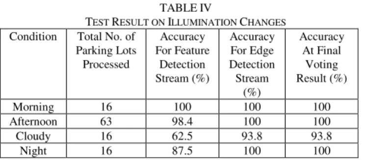
Different conditions have been chosen to represent broad possibilities of effects on the developed algorithm. These possible effects can be categorized into two groups – one on the surrounding illumination changes and the other on environment-induced image noise. Surrounding illumination changes can be represented with images captured during different hours such as sunny day time, cloudy day and night time. For night time or near-to-darkness scenarios, street lightings are expected to be available and image acquisition device is set to night operating mode. The absence of street lighting will cause total darkness which makes detection of vehicle become impossible, thus this is avoided in our tests. Shadow effect is very obvious especially for images taken in the afternoon. However, from the output, we can observe that the program is able to handle shadow effects correctly and did not misclassify them as occupied lots. Table III shows examples of different conditions due to ambient illumination. Table IV shows the result of detection under these conditions.
TABLE III
SAMPLES OF TEST RESULT ON ILLUMINATION CHANGES
Condition Input Image Output
Morning
Afternoon
Cloudy
Night
TABLE IV
TEST RESULT ON ILLUMINATION CHANGES Condition Total No. of
Parking Lots Processed
Accuracy For Feature
Detection Stream (%)
Accuracy For Edge Detection Stream
(%)
Accuracy At Final
Voting Result (%)
Morning 16 100 100 100
Afternoon 63 98.4 100 100
Cloudy 16 62.5 93.8 93.8
Night 16 87.5 100 100
Table IV shows that accuracy for feature detection stream tends to drop especially when images are captured during low illumination time, such as cloudy day or night time. However, this is saved by high accuracy for the edge detection stream which maintains more than 90%. Final occupancy detection result is very good with accuracy of more than 93%.
For the case of environmental-induced image noise, images were taken during rainy days. Rain is considered as noise to the images and can be detrimental because they appear as fine lines with edges and could cause false detection in the program stream for edge detection. Effects caused by snow are ignored as the test locations are in a tropical country. However, the authors expected severe effects caused by heavy snows as large occlusion could occurs and cause false vehicle detection. The developed algorithm is therefore meant to be used in places with no sign of snow. Table V shows examples of environmental image noise and Table VI shows the result of detection under these conditions.
TABLE V
SAMPLES OF TEST RESULT ON DIFFERENT IMAGE NOISE
Condition Input Image Output
Drizzling
Rain
Heavy Rain
After Rain
TABLE VI
TEST RESULT ON DIFFERENT IMAGE NOISE Condition Total No. of
Parking Lots Processed Accuracy For Feature Detection Stream (%) Accuracy For Edge Detection Stream (%) Accuracy At Final Voting Result (%)
Drizzling 8 100 100 100
Rain 24 95.8 91.7 95.8
Heavy Rain
32 93.8 87.5 93.8
After Rain 16 100 81.3 100
Table VI shows that accuracy for edge detection drops with the presence of heavy rain as image noise. This, however, is saved by the feature detection stream which maintains high accuracy of more than 93% when image noise presents. Final occupancy detection result is also very good with accuracy of more than 93%.
VI. CONCLUSION
Many different parking guidance systems have been developed and designed to shorten the searching time for vacant parking lots. This is especially crucial for drivers who need to search for available car parks during peak hours or when the car parks are almost full. Researches on car park occupancy information generally fall into four categories – counter-based, wired-based, wireless-based and image-based systems.
COINS has been developed using an integrated image processing approach. This particular system requires manual seeding procedure for initialization process and the program embarks on boundary search to obtain exact locations of the parking lots in the image. Normal operation uses mainly image difference, object detection, edge detection and voting algorithm. The system has been tested on a simulation model and real-case scenarios with different conditions such as weather situations and under different illumination changes. Results from the tests have been presented in this paper and shows accurate detection result of the car park occupancy. Feature detection stream is able to compensate the presence of image noise while edge detection stream is able to compensate weakness caused by low surrounding illumination.
REFERENCES
[1] M. E. Percival, and A. Sedgwick, “Information architectures for next generation car park services,” in Proc. 11th Int. Conf. Road Transport Information and Control, London, 2002, pp. 74-77.
[2] H. Kurogo, K. Takada and H. Akiyama, “Concept of a parking guidance system and its effects in the Shinjuku area – configuration, performance, and future improvement of system,” in Proc. Conf. Vehicle Navigation and Information Systems, Seattle, 1995, pp. 67-74. [3] T. Ristola, “Parking guidance system in Tapiola,” in Proc. IEE Conf.
Road Traffic Monitoring, 1992, pp.195.
[4] C. Yu and J. Liu, “A type of sensor to detect occupancy of vehicle berth in carpark,” in Proc. 7th Int. Conf. Signal Processing, 2004, pp. 2708-2711.
[5] J. Wolff, T. Heuer, H. Gao, M. Weinmann, S. Voit and U. Hartmann, “Parking monitor system based on magnetic field sensors,” in Proc. IEEE Conf. Intelligent Transportation Systems, Toronto, 2006, pp. 1275-1279.
[6] V. W. S. Tang, Y. Zheng and J. Cao, “An intelligent car park management system based on wireless sensor networks,” in Proc. Int. Sym. Pervasive Computing and Applications, Urumqi, 2006, pp. 65-70. [7] J. P. Benson, T. O’Donovan, P. O’Sullivan, U. Roedig and C. Sreenan,
“Car-park management using wireless sensor networks,” in Proc. 31st IEEE Conf. Local Computer Networks, Tampa, 2006, pp. 588-595. [8] H. D. Chon, D. Agrawal and A. El Abbadi, “NAPA: nearest available
parking lot application,” in Proc. 18th Int. Conf. Data Engineering, San Jose, 2002, pp. 496-497.
[9] J. Barton, J. Buckley, B. O’Flynn, S. C. O’Mathuna, J. P. Benson, T. O’Donovan and U. Roedig, “The D-systems project – wireless sensor networks for car-park management,” in Proc. IEEE 65th Conf. Vehicular Technology, Dublin, 2007, pp. 170-173.
[10] ParkingCarma, Inc. [Online]. Available: http://www.parkingcarma.com
[11] Streetline, Inc. [Online]. Available: http://www.streetlinenetworks.com
[12] VehicleSense, Inc. [Online]. Available: http://www.vehiclesense.com
[13] EzPARK [Online]. Available:
http://wow.eecs.berkeley.edu/ergen/EZPARK/index.htm
[14] SmartPark [Online]. Available: http://smartpark.epfl.ch
[15] L. Marchesotti, L. Marcenaro and C. Regazzoni, “A video surveillance architecture for alarm generation and video sequences retrieval,” in Proc. Int. Conf. Image Processing, 2002, pp. I-892 – I-895.
[16] P. Mills, “Image processing applications on the T9000 transputer,” in Proc. IEE Colloquium on T9000 Transputer, London, 1994, pp. 7/1 – 7/4.
[17] K. Zerzour and F. Marir, “Object-orientation and description logics techniques for implementing the indexing of surveillance video content,” in Proc. 2nd Int. Conf. Information Technology: Research and Education, 2004, pp.165-169.
[18] Z. Liu and K. Komiya, “Region-wide automatic visual search and pursuit surveillance system of vehicles and people using networked intelligent cameras,” in Proc. 6th Int. Conf. Signal Processing, 2002, pp. 945-948.
[19] J. Cotter and G. A. Jones, “Intelligent retrieval and storage of outdoor events derived from video,” in Proc. IEE Colloquium on Image Processing for Security Applications, London, 1997, pp. 8/1 – 8/7. [20] G. A. Jones and P. R. Giaccone, “Hierarchical tracking of motion in
multiple images,” in Proc. IEE Colloquium on Multiresolution Modeling and Analysis in Image Processing and Computer, London, 1995, pp. 7/1 – 7/6.
[21] S. Ozawa, “Image sensors in traffic and vehicle control,” in Proc. Conf. Vehicle Navigation and Information Systems, Yokohama, 1994, pp. PLEN27 – PLEN34.
[22] C. M. K. Tay, C. Pradalier and C. Laugier, “Vehicle detection and car park mapping using laser scanner,” in Proc. IEEE/RSJ Int. Conf. Intelligent Robots and Systems, 2005, pp. 2054-2060.
[23] Crossbow Technology, Inc. [Online]. Available: http://www.xbow.com
[24] S. Funck, N. Mohler and W. Oertel, “Determining car-park occupancy from single images,” in Proc. IEEE Sym. Intelligent Vehicles, 2004, pp. 325-328.
[25] R. C. Gonzalez and R. E. Woods, Digital Image Processing. New Jersey: Prentice-Hall, Inc., 2002, ch. 3 & 10.
[26] M. Sonka, V. Hlavac and R. Boyle, Image Processing, Analysis, and Machine Vision. California: PWS Publishing, 1999, ch. 4.
D.B.L. Bong is a Lecturer with Faculty of Engineering, Universiti Malaysia Sarawak. His research interest is mainly on image processing and artificial intelligence. He is a member of IEEE and a Corporate Member of Institution of Engineers, Malaysia (IEM).
K.C. Ting is currently a Postgraduate Candidate with Faculty of Engineering, Universiti Malaysia Sarawak. His research is on applications of image detection and recognition.
K.C. Lai is currently a Postgraduate Candidate with Faculty of Engineering, Universiti Malaysia Sarawak. His research is on imaging-based industrial machine design.