NHESSD
1, 1383–1407, 2013Forest fire danger rating – a case study
in the Bavarian Alps
C. Schunk et al.
Title Page
Abstract Introduction
Conclusions References
Tables Figures
◭ ◮
◭ ◮
Back Close
Full Screen / Esc
Printer-friendly Version Interactive Discussion
Discussion
P
a
per
|
Dis
cussion
P
a
per
|
Discussion
P
a
per
|
Discussio
n
P
a
per
|
Nat. Hazards Earth Syst. Sci. Discuss., 1, 1383–1407, 2013 www.nat-hazards-earth-syst-sci-discuss.net/1/1383/2013/ doi:10.5194/nhessd-1-1383-2013
© Author(s) 2013. CC Attribution 3.0 License.
Geoscientiic Geoscientiic
Geoscientiic Geoscientiic
Natural Hazards and Earth System Sciences
Open Access
Discussions
This discussion paper is/has been under review for the journal Natural Hazards and Earth System Sciences (NHESS). Please refer to the corresponding final paper in NHESS if available.
Forest fire danger rating in complex
topography – results from a case study in
the Bavarian Alps in autumn 2011
C. Schunk1, C. Wastl1,*, M. Leuchner1, C. Schuster1, and A. Menzel1
1
Chair of Ecoclimatology, Technische Universit ¨at M ¨unchen, Freising, Germany
*
now at: Central Institute for Meteorology and Geodynamics, Vienna, Austria
Received: 27 February 2013 – Accepted: 29 March 2013 – Published: 19 April 2013
Correspondence to: C. Schunk ([email protected])
NHESSD
1, 1383–1407, 2013Forest fire danger rating – a case study
in the Bavarian Alps
C. Schunk et al.
Title Page
Abstract Introduction
Conclusions References
Tables Figures
◭ ◮
◭ ◮
Back Close
Full Screen / Esc
Printer-friendly Version Interactive Discussion
Discussion
P
a
per
|
Dis
cussion
P
a
per
|
Discussion
P
a
per
|
Discussio
n
P
a
per
|
Abstract
Forest fire danger rating based on sparse meteorological stations is known to be poten-tially misleading when assigned to larger areas with a complex topography. This case study examines outputs of several fire danger rating systems based on data from two
meteorological stations in different elevations during a major drought period.
5
This drought was caused by a persistent high pressure system, inducing a pro-nounced temperature inversion with cool, humid conditions in the lower and warmer, dryer conditions in the upper layer. Thus, a massive drying of fuels, leading to a high fire danger level and multiple fire occurrences at higher elevations were contrasted by moderate fire danger in the valleys. The relative accuracy of fire danger rating indices
10
was studied based on a comparison with the actual fire danger as determined from expert observations, fire occurrences and fuel moisture measurements.
The results revealed that, during temperature inversion, differences in daily cycles
of meteorological parameters influence fire danger and that these are not resolved by standard meteorological stations and fire danger indices. Additional stations in higher
15
locations or high-resolution meteorological models in combination with fire danger in-dices that accept hourly input data may allow reasonable fire danger calculations under these circumstances.
1 Introduction
1.1 Forest fire danger rating fundamentals and purposes
20
Forest fires are an important natural hazard influencing public safety, ecology and management as well as productivity of forests in many countries around the world. In order to facilitate fire danger assessment on a given day and location, fire danger rating systems have been developed which integrate meteorological variables (and po-tentially additional factors) to produce numeric indices of fire potential (Chandler et al.,
NHESSD
1, 1383–1407, 2013Forest fire danger rating – a case study
in the Bavarian Alps
C. Schunk et al.
Title Page
Abstract Introduction
Conclusions References
Tables Figures
◭ ◮
◭ ◮
Back Close
Full Screen / Esc
Printer-friendly Version Interactive Discussion
Discussion
P
a
per
|
Dis
cussion
P
a
per
|
Discussion
P
a
per
|
Discussio
n
P
a
per
|
1983; Davis, 1959; Pyne et al., 1996). These can be used as a management tool, e.g. for preparedness planning, public information and warnings, mutual assistance and scheduling of prescribed fires (Baumgartner et al., 1967; Camia et al., 2006; Pyne et al., 1996).
1.2 Effects of mountain meteorological phenomena on forest fires and
5
fire danger rating
The diverse effects of mountain meteorological phenomena on forest fire danger and
behaviour have been described by several authors (e.g. Butler et al., 1998; Gorski and Farnsworth, 2000; Holden and Jolly, 2011; Mill ´an et al., 1998; Miller and Schlegel, 2006; Ryan, 1969). A comprehensive overview can be found in Sharples (2009). Key
10
phenomena include changes of temperature and relative humidity associated with
ex-position and elevation leading to a distinctive spatial distribution of fuel types, effects
on snow-melt and fuel moisture patterns, as well as diurnal mountain wind systems (e.g. thermally-caused along-slope, along-valley, cross-valley and mountain-plain wind
systems, all affecting fire behaviour and especially the direction of fire spread). More
15
complex features comprise temperature inversions (conditions more favorable to wild-fires at higher than at lower elevations), thermodynamic Foehn winds (warm and dry katabatic lee slope winds causing high fire danger and intensive fire behaviour), dy-namic channeling (a combination of upper winds and complex topography potentially leading to unexpected extreme fire behaviour and spotting), low-level jets (narrow
cur-20
rents of fast moving air influencing fire behaviour), and deflections and perturbations of airflows by mountainous terrain (mountain wind waves (e.g. gravity waves) linked to in-duced instability, strong gusty winds potentially leading to blow-ups; and thunderstorms with lightning as an ignition source) (Sharples, 2009).
Holden and Jolly (2011) modeled topographic influences on fuel moisture and fire
25
NHESSD
1, 1383–1407, 2013Forest fire danger rating – a case study
in the Bavarian Alps
C. Schunk et al.
Title Page
Abstract Introduction
Conclusions References
Tables Figures
◭ ◮
◭ ◮
Back Close
Full Screen / Esc
Printer-friendly Version Interactive Discussion
Discussion
P
a
per
|
Dis
cussion
P
a
per
|
Discussion
P
a
per
|
Discussio
n
P
a
per
|
moisture and fire danger in the study area. In addition to aspect, cold air drainage and subsequent temperature inversion were found to be a major cause of this heterogene-ity.
1.3 The general situation in the Bavarian Alps
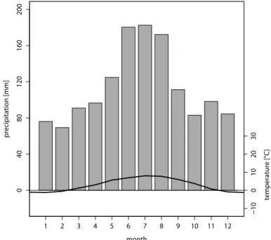
Forest fire danger along the northern rim of the European Alps and in particular in
5
southern Germany is usually quite moderate due to the temperate climate of the pre-vailing westerlies with relatively frequent year-round precipitation. Both large scale (orographically enhanced) and convective precipitation are the most important reasons for this (cf. Fig. 1); the summer maximum of precipitation is caused by convection which markedly decreases the forest fire danger when temperatures are highest. However,
10
there are occasional dry spells during which fire danger can rise significantly. A consid-erable fire hazard can result when such periods occur in spring, when the dead ground fuels (grass) remaining from the previous year dry most rapidly.
Overall, these conditions lead to an average of 36 forest fires per year, affecting an
area of 19.8 ha (reference period 2005–2011) in the whole State of Bavaria (total area
15
70 552 km2, of which 35 % is forested). Most of these (few and small) fires occur in the
lowlands with, on average, only two fires per year (8.8 ha burnt area per year) taking place in the Alpine area itself.
However, vulnerability to forest fires is much higher in the Alpine area than in the plains, because the steepness of the terrain, as well as the relative openness of forests
20
near the timber line, cause much faster drying of fuels, more severe fire behaviour and
more difficult fire-fighting operations (also reflected in the larger average burnt area per
fire). Additionally, most Alpine forests have important protective functions (e.g. against avalanches, rock fall and debris flows) and a loss or disturbance of those forests is especially worrying. Last but not least, forest restoration in this terrain is definitely more
25
NHESSD
1, 1383–1407, 2013Forest fire danger rating – a case study
in the Bavarian Alps
C. Schunk et al.
Title Page
Abstract Introduction
Conclusions References
Tables Figures
◭ ◮
◭ ◮
Back Close
Full Screen / Esc
Printer-friendly Version Interactive Discussion
Discussion
P
a
per
|
Dis
cussion
P
a
per
|
Discussion
P
a
per
|
Discussio
n
P
a
per
|
1.4 Autumn 2011 weather conditions
In autumn 2011, a meteorological situation occurred which resulted in a massive fire danger at the northern rim of the European Alps at a time when the first snows would normally have been expected. During this time, hardly any precipitation occurred due to persistent high pressure systems over Central Europe for more than one month.
5
Mean precipitation recorded for the whole of Germany (approx. 3 mm) indicates that November 2011 was the driest month since the start of systematic meteorological ob-servations in 1881 (DWD, 2011a). At many meteorological stations, no precipitation at all was registered. In contrast to the lowlands, where this drought event was accompa-nied mostly by foggy and cold weather, clear skies and high temperatures prevailed at
10
higher elevations (DWD, 2011a; Zimmermann and Raspe, 2012; Raspe et al., 2012). This was due to strong subsidence in the high pressure systems causing very stable conditions with a distinctive temperature inversion during the nights and early morn-ings.
The fire danger was further increased by dry-warm katabatic Foehn winds from the
15
south of the Alps on several days. In addition, some annual live fuels had already died
offin a previous cold period and thus responded much faster to the drought event.
These meteorological conditions led to a massive drying of fuels: moisture contents
<15 % dry-weight-basis in surface fuels (dead grass and forest litter) were measured
by the authors during the dry period. Under this prevailing high fire danger, several
20
fires occurred in higher elevation Alpine forests in Germany and Austria; one of these (the Sylvenstein reservoir fire) caused great concern as it burned for several days, was
extremely difficult to put out, and with 15 ha accounted for almost half (47 %) of the
annual area burnt in the State of Bavaria (Germany) in 2011.
Although this severe fire danger situation (by local standards) was very unusual, it
25
NHESSD
1, 1383–1407, 2013Forest fire danger rating – a case study
in the Bavarian Alps
C. Schunk et al.
Title Page
Abstract Introduction
Conclusions References
Tables Figures
◭ ◮
◭ ◮
Back Close
Full Screen / Esc
Printer-friendly Version Interactive Discussion
Discussion
P
a
per
|
Dis
cussion
P
a
per
|
Discussion
P
a
per
|
Discussio
n
P
a
per
|
DMC as well as hourly versions of McArthur’s FFDI and FFMC) during this period,
focusing on the differences between the actual and calculated fire danger in the valleys
and at higher elevations and their implications for fire danger rating and management.
2 Methods
2.1 Study site
5
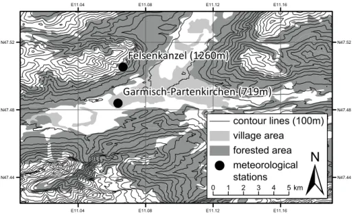
In order to calculate fire danger indices for different elevations, a location within the
Northern Alps was selected where two meteorological stations with a marked diff
e-rence in elevation exist in close proximity. Garmisch-Partenkirchen, Germany is lo-cated in a wide basin surrounded by the Ammer Mountains (elevations up to 2340 m a.s.l.) to the northwest, the Ester Mountains (elevations up to 2086 m a.s.l.) to the east
10
and the Wetterstein Mountains (including the Zugspitze, at 2962 m a.s.l. the highest mountain in Germany) to the south. The flat basin is used mostly for human settle-ments, infrastructure and agriculture, whereas the lower mountain slopes are covered by forests (approx. 800–1600 m a.s.l., depending on slope, exposition and human use).
These forests are usually mixed forests dominated by Norway spruce (Picea abies
15
(L.) Karst.), European silver fir (Abies albaMill.), European beech (Fagus sylvaticaL.)
and Sycamore (Acer pseudoplatanus L.), although pure stands, especially of Norway
spruce, can also occur. On south-facing slopes, a significant amount of Scots pine (
Pi-nus sylvestris L.) stands can be found. Higher elevations are covered by grass, dwarf
trees and shrubs, mainly Mugo pine (Pinus mugoT.), or bare rock.
20
2.2 Meteorological measurements
The meteorological station “Garmisch-Partenkirchen” is located on the valley floor
(719 m a.s.l., 47.48◦N 11.06◦E). It is run by the German Meteorological Service
(Deutscher Wetterdienst, DWD), and supplies hourly values of temperature and rel-ative humidity as well as hourly means of wind speed and hourly precipitation sums.
NHESSD
1, 1383–1407, 2013Forest fire danger rating – a case study
in the Bavarian Alps
C. Schunk et al.
Title Page
Abstract Introduction
Conclusions References
Tables Figures
◭ ◮
◭ ◮
Back Close
Full Screen / Esc
Printer-friendly Version Interactive Discussion
Discussion
P
a
per
|
Dis
cussion
P
a
per
|
Discussion
P
a
per
|
Discussio
n
P
a
per
|
A second meteorological station “Felsenkanzel” (1260 m a.s.l., 47.51◦N 11.07◦E,
2.4 km horizontal distance from Garmisch-Partenkirchen station) is operated by the Technische Universit ¨at M ¨unchen. This station is located on a steep south-facing slope near the upper end of the altitudinal forest range and measures selected standard meteorological parameters (temperature, relative humidity, precipitation, and others) at
5
10 min intervals. The location of both stations as well as the local topography and areas covered by forest and human settlements are shown in Fig. 2.
In addition, atmospheric sounding data were obtained from the nearby radiosonde
station at Innsbruck airport (47.26◦N 11.35◦E, approx. 30 km from
Garmisch-Partenkirchen) to illustrate the vertical stratification of the atmosphere.
10
2.3 Data processing and fire danger index calculation
All available data for both stations were obtained for 2011. The 10 min data of Felsenkanzel were subsequently converted to hourly values and missing parameters (wind speed) were filled by respective data from Garmisch-Partenkirchen, since it was the closest meteorological station available. Some data gaps still remained, but these
15
were short enough not to have any noticeable influence on index calculations.
A wide range of fire danger indices were calculated representing fire danger rating systems from several continents (North America, Europe, and Australia), and com-prising very simple to rather complex formulations. Here, we only provide some brief information about these indices. Both fast- and slow-reacting indices are all based on
20
standard meteorological observations only (since snow parameters and phenology, which are required for some specific indices, were not measured at Felsenkanzel). In order to identify even small variations in the index behaviour, all analyses are based on the direct index outputs, without any classification into a danger scale.
The Angstrom index is a simple Swedish fire danger index based on daily values of
25
NHESSD
1, 1383–1407, 2013Forest fire danger rating – a case study
in the Bavarian Alps
C. Schunk et al.
Title Page
Abstract Introduction
Conclusions References
Tables Figures
◭ ◮
◭ ◮
Back Close
Full Screen / Esc
Printer-friendly Version Interactive Discussion
Discussion
P
a
per
|
Dis
cussion
P
a
per
|
Discussion
P
a
per
|
Discussio
n
P
a
per
|
McArthur’s Forest Fire Danger Index (FFDI, Mark 5, Noble et al., 1980) is used in Australia to rate fire danger. It is calculated from daily values of temperature, relative humidity, wind speed, and the Keetch–Byram Drought Index (Keetch and Byram, 1968). Calculations at higher temporal resolution were performed following the procedure de-scribed in Boer et al. (2008).
5
Both the Fine Fuel Moisture Code (FFMC) and the DuffMoisture Code (DMC) are
components of the Canadian Forest Fire Danger Rating System (CFFDRS) and have been described in Van Wagner (1987) and Van Wagner and Pickett (1985). They are bookkeeping systems meant to track the moisture content of pre-defined fuels based on 12:00 LST meteorological observations. Whereas the fast-responding FFMC
cov-10
ers forest litter and other dead fine fuels and takes into account temperature, relative
humidity, precipitation and wind speed, the DMC represents a 5 kg m−2 decomposing
organic layer, not requiring wind speed inputs (Van Wagner, 1987). Starting values for 1 January were defined as 85 for FFMC and 6 for DMC (Van Wagner and Pickett, 1985). Hourly values of FFMC can generally be calculated using the methods of Lawson
15
et al. (1996) and Van Wagner (1977). There has been some discussion regarding the relative performance of those methods (Anderson, 2009; Beck and Armitage, 2001), however we preferred Van Wagner’s (1977) method since it calculates hourly FFMC directly from hourly inputs.
2.4 Data analysis
20
The meteorological data and the fire danger indices described above were plotted for several time periods. Qualitative comparisons between the particular index progres-sions were made from visual inspections of these plots.
Independent fire danger assessments were available in the form of expert observa-tions and fire occurrence data. Gravimetric measurements of dead fine fuel (forest litter,
25
NHESSD
1, 1383–1407, 2013Forest fire danger rating – a case study
in the Bavarian Alps
C. Schunk et al.
Title Page
Abstract Introduction
Conclusions References
Tables Figures
◭ ◮
◭ ◮
Back Close
Full Screen / Esc
Printer-friendly Version Interactive Discussion
Discussion
P
a
per
|
Dis
cussion
P
a
per
|
Discussion
P
a
per
|
Discussio
n
P
a
per
|
fire location. Although they support the statements made in this paper, unfortunately all of these additional observations and measurements were sparse and are therefore not adequate for further statistical analysis.
All calculations and plotting were performed with R, version 2.15.0, its package Ra-dioSonde, version 1.3, and ArcMAP, version 9.3.
5
3 Results
3.1 Meteorological conditions during the study period
Detailed meteorological conditions at both stations during the period of interest are plotted in Fig. 3. No precipitation was recorded at either station in the period from 27 October 2011 to 3 December 2011. During this period, temperatures ranged between
10
−6.6◦C and 19.5◦C and relative humidity between 19 and 100 % (extreme values from
both stations). However, distinct differences were observed between the two stations.
On the valley floor, Garmisch-Partenkirchen experienced more pronounced daily cy-cles of temperature and humidity, and the mean daily minimum temperature in the
period was well below freezing (−1.5◦C). Daily maximum relative humidity was
fre-15
quently close to 100 % (cf. Fig. 3). In contrast the Felsenkanzel station at 1260 m a.s.l.
measured less extreme daily cycles with a mean daily minimum temperature of 4.9◦C
and a mean daily maximum humidity of 67.2 %.
This meteorological situation can be considered as a typical example of a stable boundary layer with nightly temperature inversion in complex terrain as it frequently
oc-20
curs in most mountainous areas. Its relevance for forest fire danger will be considered
later in this paper (Sects. 3.2 and 3.3). Southerly Foehn winds had only minimal effects
in this area and period, since a large amount of cold air was present in the valley and the high, west–east oriented Wetterstein Mountain range acted as a barrier for these southerly winds.
NHESSD
1, 1383–1407, 2013Forest fire danger rating – a case study
in the Bavarian Alps
C. Schunk et al.
Title Page
Abstract Introduction
Conclusions References
Tables Figures
◭ ◮
◭ ◮
Back Close
Full Screen / Esc
Printer-friendly Version Interactive Discussion
Discussion
P
a
per
|
Dis
cussion
P
a
per
|
Discussion
P
a
per
|
Discussio
n
P
a
per
|
An atmospheric sounding taken at Innsbruck during this period is shown in Fig. 4. From this Skew-T Log-P diagram, information about vertical profiles of temperature, dew point, and wind speed and direction through the atmosphere can be obtained. The temperature inversion near the ground is clearly visible at a height of up to 1600 m (840 hPa). Close to the ground, temperature and dew point were identical as the air was
5
saturated and fog occurred. With increasing altitude, the temperature-dew point spread
increased until reaching a maximum of 41◦C at 4550 m (580 hPa). In this layer, very
dry air was present due to strong synoptical subsidence in the high pressure system. While at lower elevations almost no wind was measured, south–westerly to southerly winds of 21–39 knots could be found at higher elevations (above 4550 m/580 hPa).
10
3.2 Annual progression of selected fire danger indices
The annual progression of four of the selected forest fire danger indices for 2011 is shown in Fig. 5. In addition to the autumn event, a major drought period occurred in spring (end of April–beginning of May 2011) and another minor one in summer (end of August 2011).
15
Low values of the Angstrom index represent high fire danger and high values low fire danger, as opposed to all other indices shown here. Because of this, the Angstrom index values are plotted inversely in Fig. 5. Due to the high day-to-day variation in this non-cumulative index, the high danger periods described above do not show up very clearly in the index raw values of this graph. However, a local decrease of the Angstrom
20
values during these periods and a rise of the index afterwards are detectable.
The Australian McArthur Forest Fire Danger Index also tends to react quickly, espe-cially when dry conditions are combined with high wind speeds, and reveals the first and second dry periods rather clearly. While the summer event accounts for the ma-ximum McArthur value, only a very moderate rise in the index could be observed in
25
NHESSD
1, 1383–1407, 2013Forest fire danger rating – a case study
in the Bavarian Alps
C. Schunk et al.
Title Page
Abstract Introduction
Conclusions References
Tables Figures
◭ ◮
◭ ◮
Back Close
Full Screen / Esc
Printer-friendly Version Interactive Discussion
Discussion
P
a
per
|
Dis
cussion
P
a
per
|
Discussion
P
a
per
|
Discussio
n
P
a
per
|
The CFFDRS’s Fine Fuel Moisture Code (FFMC) is yet another fast reacting index, which gets close to its maximum value (100) after a few days without precipitation. During all danger periods, high or even near-maximum values of the FFMC could be
observed. As the end of the scale was (almost) reached, there was no clear diff
erenti-ation of the relative severity of the respective danger periods.
5
The Duff Moisture Code (DMC), however, responds more slowly to drought and
shows the three events rather clearly. Because of its slower response, it suggests that in autumn the danger level was rising until the end of the drought event. The maximum danger values were obtained for the spring event (maximum value of 46), closely fol-lowed by the autumn (maximum value of 38) and summer drought (maximum value of
10
35) and another short September drought event (maximum value of 26).
When comparing the indices calculated for the two different climate stations (black
and gray lines in Fig. 5), it could be noted that fire danger at Felsenkanzel was almost always equal or even lower than Garmisch-Partenkirchen. This is true even for large parts of the autumn drought period, when the actual fire danger, as described above,
15
was supposedly much more severe at higher (e.g. Felsenkanzel) than at lower (e.g. Garmisch-Partenkirchen) elevations.
Supporting evidence for this exceptional pattern of fire danger in autumn 2011 is also found in expert-based assessments (e.g. in DWD, 2011a; Raspe et al., 2012;
Zimmermann and Raspe, 2012 and information from local forest officers). It is further
20
confirmed by multiple fire occurrences at these elevations in Germany and Austria and the fuel moisture measurements carried out by the authors. The latter ones showed distinctly lower values (and thus greater fire danger) at mid and higher elevations (gravi-metric moisture content for dead grass and forest litter between 10 and 25 %) than near
the valley bottom (litter moisture content>40 %). Furthermore, the altitudinal variation
25
NHESSD
1, 1383–1407, 2013Forest fire danger rating – a case study
in the Bavarian Alps
C. Schunk et al.
Title Page
Abstract Introduction
Conclusions References
Tables Figures
◭ ◮
◭ ◮
Back Close
Full Screen / Esc
Printer-friendly Version Interactive Discussion
Discussion
P
a
per
|
Dis
cussion
P
a
per
|
Discussion
P
a
per
|
Discussio
n
P
a
per
|
3.3 Diurnal meteorological conditions and their impact on fire danger and
fire danger rating system calculations
In order to more closely investigate this striking fact, meteorological conditions and selected fire danger indices have been plotted for part of the autumn drought period (19–30 November 2011) in Fig. 7.
5
During this period it was quite obvious that the daily amplitudes of both tem-perature and relative humidity were generally much more pronounced in Garmisch-Partenkirchen (black lines) than at Felsenkanzel (gray lines). In fact, temperature was mostly very low and humidity generally very high at Garmisch-Partenkirchen, only for a short period after noon every day, the temperatures in the valley exceeded those
10
measured at Felsenkanzel and the relative humidity was equal. The reason for this was the disintegration of the nocturnal temperature inversion by strong solar heating during the day in the prevailing high pressure systems. During the night the clear sky caused strong radiative cooling and a gathering of the coldest air in the valley floor
(i.e. at Garmisch-Partenkirchen in our case). Hence, the meteorological differences
15
between Garmisch-Partenkirchen and Felsenkanzel were more pronounced during the night. The strong daily cycle for Garmisch-Partenkirchen can be clearly observed at the beginning of the plotted period (19–22 November 2011), during which the previously mentioned Sylvenstein reservoir forest fire started (20 November 2011). Later on, with decreasing day length, the nocturnal temperature inversion and associated fog
disinte-20
grated less evenly, leading to less regular cycles of temperature and relative humidity (e.g. 24 November 2011).
Throughout the selected period, both the daily FFMC and McArthur’s FFDI values (dashed lines in Fig. 7) were elevated or high and in contrast to reality, the fire danger at both stations was rated as almost identical in the beginning. From 23 November 2011
25
NHESSD
1, 1383–1407, 2013Forest fire danger rating – a case study
in the Bavarian Alps
C. Schunk et al.
Title Page
Abstract Introduction
Conclusions References
Tables Figures
◭ ◮
◭ ◮
Back Close
Full Screen / Esc
Printer-friendly Version Interactive Discussion
Discussion
P
a
per
|
Dis
cussion
P
a
per
|
Discussion
P
a
per
|
Discussio
n
P
a
per
|
The hourly calculated fire danger indices (solid lines in Fig. 7) manage to cap-ture the situation much better with both the hourly FFMCs and McArthur’s FFDIs
showing a marked difference between Garmisch-Partenkirchen and Felsenkanzel from
19 November 2011 onwards. Even a diurnal variation is apparent for Garmisch-Partenkirchen. Once more, a much more rapid reaction of McArthur’s index to the
5
meteorological input parameters is found.
4 Discussion
Daily fire danger rating systems seem to misjudge the altitudinal differences in fire
danger when a temperature inversion is present, as observed in the selected example of the autumn 2011 situation (especially in the period 19–22 November 2011).
10
The reason for this lies in the missing sensitivity of most daily fire danger rating sys-tems to the diurnal cycle of meteorological conditions. All daily fire danger indices con-sidered in this study, as well as most known fire danger rating systems, are calculated from meteorological values between 12:00 and 14:00 LST. During this period, as can be gathered from Fig. 7 for our example, meteorological conditions in a valley and a
mid-15
slope position may be almost identical because the temperature inversion (partially) disintegrates during the day due to solar heating (cf. also Fig. 8 in Holden and Jolly, 2011). Therefore the indices use similar input parameters for both locations/stations and are bound to rate fire danger at similar levels. In our example, they neither include the low temperatures and very high humidity at Garmisch-Partenkirchen (so that dew
20
and even rime may occur and wet the fuels) at night, nor the almost constant higher temperatures and lower relative humidity (which are likely to cause substantial fuel drying) at Felsenkanzel. Therefore and because temperature inversions are a regu-lar feature in most complex topographic areas, we state that not only can fire danger calculations from lowland stations be expected to be misleading (Sharples, 2009), but
25
NHESSD
1, 1383–1407, 2013Forest fire danger rating – a case study
in the Bavarian Alps
C. Schunk et al.
Title Page
Abstract Introduction
Conclusions References
Tables Figures
◭ ◮
◭ ◮
Back Close
Full Screen / Esc
Printer-friendly Version Interactive Discussion
Discussion
P
a
per
|
Dis
cussion
P
a
per
|
Discussion
P
a
per
|
Discussio
n
P
a
per
|
The assessment based on the hourly calculated FFMC (Van Wagner, 1977) and
McArthur’s index (Boer et al., 2008) is quite different and shows a distinctly higher
danger at Felsenkanzel and a diurnal variation of the danger level in Garmisch-Partenkirchen. Therefore this type of index seems much closer to the observed reality. However, the situation at Garmisch-Partenkirchen should probably be rated even less
5
severe, since fuel wetting by dew/rime occurred and there is no such wetting function implemented in either of the systems.
Another fire danger rating system that might be able to correctly account for the phe-nomenon described here is the National Fire Danger Rating System (USA, Bradshaw et al., 1983), which uses maximum and minimum temperature and relative humidity in
10
some of its components. Furthermore, there are physically-based fuel moisture models available (e.g. Wittich, 2005; Matthews et al., 2007), which can also operate with hourly
or higher resolved meteorological data. A new fire danger index
Waldbrandgefahrenin-dex (WBI; DWD, 2011b) is currently in development at the German Meteorological
Service, which will also be able to provide this capability.
15
5 Conclusions
From the fuel measurements, expert observations and fire occurrences during our case study, we can confirm the findings of Holden and Jolly (2011) and Sharples (2009), who stated that temperature inversions may produce unusual and highly heterogeneous patterns of fire danger in mountainous areas.
20
Due to the availability of meteorological data from a mid-slope and a valley station, we managed to analyze how such a situation, which may occur at any given time in most complex topographic areas in the world, is resolved by fire danger rating indices. In order to capture the relevant atmospheric conditions, meteorological stations in the valleys and at higher elevations (where forests or other vegetation still occur) or
high-25
NHESSD
1, 1383–1407, 2013Forest fire danger rating – a case study
in the Bavarian Alps
C. Schunk et al.
Title Page
Abstract Introduction
Conclusions References
Tables Figures
◭ ◮
◭ ◮
Back Close
Full Screen / Esc
Printer-friendly Version Interactive Discussion
Discussion
P
a
per
|
Dis
cussion
P
a
per
|
Discussion
P
a
per
|
Discussio
n
P
a
per
|
used for NFDRS calculations in the US are typically located at mid-elevation south-facing slopes, Cohen and Deeming, 1985; Holden and Jolly, 2011). Fire danger rating systems to be used in such areas and situations should be able to correctly account for variations in the daily cycle between the individual stations or grid points. Potential indices are components of the National Forest Fire Danger Rating System (Bradshaw
5
et al., 1983), the hourly version of the McArthur Forest Fire Danger Index (Noble et al., 1980) and the hourly Fine Fuel Moisture Code (Van Wagner, 1977). Further investi-gation as to which of these (or other additional) indices are best suited for fire danger rating purposes under the conditions described in this paper are necessary, as our current assessment is limited to qualitative comparisons.
10
Acknowledgements. The authors would like to acknowledge financial support from the Bavar-ian State Ministry for Food, Agriculture and Forestry through project KLIP 8 and from the Eu-ropean Union through the Alpine Space ALP FFIRS (no. 15-2-3-IT) project as well as from the European Research Council under the European Union’s Seventh Framework Programme (FP7/2007-2013)/ERC grant agreement no. 282250. In this paper, meteorological measure-15
ments supplied by the German Meteorological Service (Deutscher Wetterdienst, DWD), the KLIMAGRAD project (funded by the Bavarian State Ministry for the Environment and Pub-lic Health) and the University of Wyoming’s radiosonde database (http://weather.uwyo.edu/ upperair/sounding.html) have been used. A digital terrain model has been provided by the
Bavarian State Office for Surveying and Geographic Information, and Corine Landcover data
20
(CLC2006) by the Federal Office for the Environment, DLR-DFD 2009 has been used in Fig. 2.
The authors furthermore gratefully acknowledge the support by the Faculty Graduate Center Weihenstephan of TUM Graduate School at Technische Universit ¨at M ¨unchen, Germany.
References
Anderson, K. R.: A comparison of hourly fine fuel moisture code calculations within Canada, 25
in: Eigth Symposium on Fire and Forest Meteorology, Kalispell, MT, 13–15 October 2009, American Meteorological Society, Boston, 3A.4–3A.10, 2009.
NHESSD
1, 1383–1407, 2013Forest fire danger rating – a case study
in the Bavarian Alps
C. Schunk et al.
Title Page
Abstract Introduction
Conclusions References
Tables Figures
◭ ◮
◭ ◮
Back Close
Full Screen / Esc
Printer-friendly Version Interactive Discussion
Discussion
P
a
per
|
Dis
cussion
P
a
per
|
Discussion
P
a
per
|
Discussio
n
P
a
per
|
Ern ¨ahrung, Landwirtschaft und Forsten, Ministerialforstabteilung, 36, 57–79, 1967 (in Ger-man).
Beck, J. A. and Armitage, O. B.: Diurnal fine fuel moisture and FFMC characteristics at northern latitudes, in: Proceedings of the 22nd Tall Timbers Fire Ecology Conference: Fire in Temper-ate, Boreal, and Montane Ecosystems, Tallahassee, FL, 211–221, 2001.
5
Boer, M. M., Sadler, R. J., Bradstock, R. A., Gill, A. M., and Grierson, P. F.: Spatial scale invari-ance of southern Australian forest fires mirrors the scaling behaviour of fire-driving weather events, Landscape Ecol., 23, 899–913, doi:10.1007/s10980-008-9260-5, 2008.
Bradshaw, L. S., Deeming, J. E., Burgan, R. E., and Cohen, J. D.: The 1978 National Fire-Danger Rating System: technical documentation, USDA Forest Service General Technical 10
Report INT-169, Ogden, Utah, 1983.
Butler, B. W., Bartlette, R. A., Bradshaw, L. S., Cohen, J. D., Andrews, P. L., Putnam, T., and Mangan, R. J.: Fire behavior associated with the 1994 South Canyon Fire on Storm King Mountain, Colorado, USDA Forest Service, Research Paper RMRS-RP-9, Ogden, Utah, 1998.
15
Camia, A., Barbosa, P., Amatulli, G., and San-Miguel-Ayanz, J.: Fire danger rating in the Euro-pean Forest Fire Information System (EFFIS): Current developments, Forest. Ecol. Manag., 234, 20 pp., doi:10.1016/j.foreco.2006.08.036, 2006.
Chandler, C., Cheney, P., Thomas, P., Trabaud, L., and Williams, D.: Fire in Forestry – Forest
Fire Behaviour and Effects, John Wiley & Sons, New York, Chinchester, Brisbane, Toronto,
20
Singapore, 1983.
Cohen, J. D. and Deeming, J. E.: The National Fire Danger Rating System: Basic Equations, USDA Forest Service General Technical Report PSW-82, Berkeley, California, 1985. Davis, K. P.: Forest Fire: Control and Use, McGraw-Hill Book Company, Inc., New York, Toronto,
London, 1959. 25
Dowdy, A. J., Mills, G. A., Finkele, K., and de Groot, W.: Australian fire weather as represented by the McArthur Forest Fire Danger Index and the Canadian Forest Fire Weather Index, The Centre for Australian Weather and Climate Research, CAWCR Technical Report No. 10, Melbourne, Australia, 2009.
DWD: Deutschlandwetter im November 2011, German Meteorological Service (DWD), press 30
release dated 30 November 2011, Offenbach, Germany, 2011a.
DWD: Informationen zum Waldbrandgefahrenindex WBI, German Meteorological Service
NHESSD
1, 1383–1407, 2013Forest fire danger rating – a case study
in the Bavarian Alps
C. Schunk et al.
Title Page
Abstract Introduction
Conclusions References
Tables Figures
◭ ◮
◭ ◮
Back Close
Full Screen / Esc
Printer-friendly Version Interactive Discussion
Discussion
P
a
per
|
Dis
cussion
P
a
per
|
Discussion
P
a
per
|
Discussio
n
P
a
per
|
Content/Landwirtschaft/Warndienste/Waldbrand/wbx Informationen,templateId=raw,
property=publicationFile.pdf/wbx Informationen.pdf, last access: 15 April 2013, 2011b (in
German).
Gorski, C. J. and Farnsworth, A.: Fire weather and smoke management, Chapter 13, in: Moun-tain Meteorology Fundamentals and Applications, Oxford University Press, New York, 2000. 5
Holden, Z. A. and Jolly, W. M.: Modeling topographic influences on fuel moisture and fire dan-ger in complex terrain to improve wildland fire management decision support, Forest. Ecol. Manag., 262, 2133–2141, doi:10.1016/j.foreco.2011.08.002, 2011.
Keetch, J. J. and Byram, G. M.: A drought index for forest fire control, USDA Forest Service Research Paper SE-38, Asheville, North Carolina, 1968.
10
Langholz, H. and Schmidtmayer, E.: Meteorologische Verfahren zur Absch ¨atzung des Wald-brandrisikos, Allg. Forst Z., 48, 394–396, 1993 (in German).
Lawson, B. D., Armitage, O. B., and Hoskins, W. D.: Diurnal variation in the Fine Fuel Moisture Code: tables and computer source code, Canadian Forest Service, FRDA Report 245, BC Ministry of Forests, Victoria, BC, 1996.
15
Matthews, S., McCaw, W. L., Neal, J. E., and Smith, R. G.: Testing a process-based fine fuel moisture model in two forest types, Can. J. Forest Res., 37, 23–35, doi:10.1139/x06-207, 2007.
Mill ´an, M. M., Estrala, M. J., and Badenas, C.: Meteorological processes relevant to for-est fire dynamics on the Spanish Mediterranean coast, J. Appl. Meteorol., 37, 83–100, 20
10.1175/1520-0450(1998)037<0083:MPRTFF>2.0.CO;2, 1998.
Miller, N. L. and Schlegel, N. J.: Climate change-projected fire weather sensivity: California Santa Ana wind occurrence, Geophys. Res. Lett., 33, L15711, doi:10.1029/2006GL025808, 2006.
Noble, I. R., Bary, G. A. V., and Gill, A. M.: McArthur’s fire-danger meters expressed as equa-25
tions, Aust. J. Ecol., 5, 201–203, doi:10.1111/j.1442-9993.1980.tb01243.x, 1980.
Pyne, S. K., Andrews, P. L., and Laven, R. D.: Introduction to Wildland Fire, 2nd Edn., John Wiley & Sons, New York, Chinchester, Brisbane, Toronto, Singapore, 1996.
Raspe, S., Grimmeisen, W., and Zimmermann, L.: Lange Transpirationsphase der B ¨aume und Niederschl ¨age ohne Regen, LWF aktuell, 86, 32–33, 2012 (in German).
30
NHESSD
1, 1383–1407, 2013Forest fire danger rating – a case study
in the Bavarian Alps
C. Schunk et al.
Title Page
Abstract Introduction
Conclusions References
Tables Figures
◭ ◮
◭ ◮
Back Close
Full Screen / Esc
Printer-friendly Version Interactive Discussion
Discussion
P
a
per
|
Dis
cussion
P
a
per
|
Discussion
P
a
per
|
Discussio
n
P
a
per
|
Sharples, J. J.: An overview of mountain meteorological effects relevant to fire behaviour and
bushfire risk, Int. J. Wildland Fire, 18, 737–754, doi:10.1071/WF08041, 2009.
Van Wagner, C. E.: A Method of Computing Fine Fuel Moisture Content Throughout the Diurnal Cycle, Canadian Forest Service, Information Report PS-X-69, Chalk River, Ontario, 1977. Van Wagner, C. E.: Development and structure of the Canadian forest fire weather index Sys-5
tem, Technical Report 35, Canadian Forestry Service Forestry, Ottawa, 1987.
Van Wagner, C. E. and Pickett, T. L.: Equations and FORTRAN Program for the Canadian For-est Fire Weather Index System, ForFor-estry Technical Report 33, Canadian ForFor-estry Service, Ottawa, 1985.
Wittich, K.-P.: A single-layer litter-moisture model for estimating forest-fire danger, Meteorol. Z. 10
14, 157–164, doi:10.1127/0941-2948/2005/0017, 2005.
NHESSD
1, 1383–1407, 2013Forest fire danger rating – a case study
in the Bavarian Alps
C. Schunk et al.
Title Page
Abstract Introduction
Conclusions References
Tables Figures
◭ ◮
◭ ◮
Back Close
Full Screen / Esc
Printer-friendly Version Interactive Discussion
Discussion
P
a
per
|
Dis
cussion
P
a
per
|
Discussion
P
a
per
|
Discussio
n
P
a
per
|
1 2 3 4 5 6 7 8 9 10 11 12
0
4
0
80
120
160
200
−10
0
1
0
2
0
3
0
month
precipitation [mm]
temperature [°C]
Fig. 1. Climograph for the meteorological station Garmisch-Partenkirchen (719 m a.s.l.,
47.48◦N 11.06◦E), black line: mean monthly temperature, gray bars: mean monthly
NHESSD
1, 1383–1407, 2013Forest fire danger rating – a case study
in the Bavarian Alps
C. Schunk et al.
Title Page
Abstract Introduction
Conclusions References
Tables Figures
◭ ◮
◭ ◮
Back Close
Full Screen / Esc
Printer-friendly Version Interactive Discussion
Discussion
P
a
per
|
Dis
cussion
P
a
per
|
Discussion
P
a
per
|
Discussio
n
P
a
per
|
N47.52
N47.48
N47.44
!
(
!
(
E11.16 E11.16
E11.12 E11.12
E11.08 E11.08
E11.04 E11.04
N47.52
N47.48
N47.44
Felsenkanzel (1260m)
artenkirchen (719m) Garmisch-P
village area forested area
!
meteorologicalstations
±
0 1 2 3 4 5 kmcontour lines (100m)
NHESSD
1, 1383–1407, 2013Forest fire danger rating – a case study
in the Bavarian Alps
C. Schunk et al.
Title Page
Abstract Introduction
Conclusions References
Tables Figures
◭ ◮
◭ ◮
Back Close
Full Screen / Esc
Printer-friendly Version Interactive Discussion
Discussion
P
a
per
|
Dis
cussion
P
a
per
|
Discussion
P
a
per
|
Discussio
n
P
a
per
|
temperature
[°C]
04
0
8
0
relative
humidity [%]
01
0
date
precipitation
[mm]
10.10. 20.10. 30.10. 09.11. 19.11. 29.11.
Garmisch−Partenkirchen Felsenkanzel
20
0
20
10
NHESSD
1, 1383–1407, 2013Forest fire danger rating – a case study
in the Bavarian Alps
C. Schunk et al.
Title Page
Abstract Introduction
Conclusions References
Tables Figures
◭ ◮
◭ ◮
Back Close
Full Screen / Esc
Printer-friendly Version Interactive Discussion
Discussion
P
a
per
|
Dis
cussion
P
a
per
|
Discussion
P
a
per
|
Discussio
n
P
a
per
|
temperature [°C]
pressure [hPa]
−40 −30 −20 −10 0 10 20
1000
700
500
300
200
100
24 20 16 12 8
NHESSD
1, 1383–1407, 2013Forest fire danger rating – a case study
in the Bavarian Alps
C. Schunk et al.
Title Page
Abstract Introduction
Conclusions References
Tables Figures
◭ ◮
◭ ◮
Back Close
Full Screen / Esc
Printer-friendly Version Interactive Discussion
Discussion
P
a
per
|
Dis
cussion
P
a
per
|
Discussion
P
a
per
|
Discussio
n
P
a
per
|
Angstrom []
8642 0
5
10
15
McArthur []
Garmisch-Partenkirchen Felsenkanzel
0
2
04
06
08
0
month
FFMC []
Jan Mar May Jul Sep Nov
0
1
02
03
04
0
month
DMC []
Jan Mar May Jul Sep Nov Jan
NHESSD
1, 1383–1407, 2013Forest fire danger rating – a case study
in the Bavarian Alps
C. Schunk et al.
Title Page
Abstract Introduction
Conclusions References
Tables Figures
◭ ◮
◭ ◮
Back Close
Full Screen / Esc
Printer-friendly Version Interactive Discussion
Discussion
P
a
per
|
Dis
cussion
P
a
per
|
Discussion
P
a
per
|
Discussio
n
P
a
per
|
−5
5
1
5
temper ature [°C]
20
60
relative
humidity [%]
75
85
036
date
McArthur []
19.11. 20.11. 21.11. 22.11. 23.11. 24.11. 25.11. 26.11. 27.11. 28.11. 29.11. 30.11.
FFMC []