Regulations in the field of Geo-Information
Yaron FELUS, Eran KEINAN, Ronen REGEVSurvey of Israel, Lincoln 1, Tel-Aviv, Israel (Felus, Eran, Regev)@mapi.gov.il
Key words: Standards, Mapping, Geodesy, Photogrammetry
ABSTRACT
The geomatics profession has gone through a major revolution during the last two decades with the emergence of advanced GNSS, GIS and Remote Sensing technologies. These technologies have changed the core principles and working procedures of geomatics professionals. For this reason, surveying and mapping regulations, standards and specifications should be updated to reflect these changes.
In Israel, the "Survey Regulations" is the principal document that regulates the professional activities in four key areas geodetic control, mapping, cadastre and Georaphic information systems. Licensed Surveyors and mapping professionals in Israel are required to work according to those regulations. This year a new set of regulations have been published and include a few major amendments as follows:
In the Geodesy chapter, horizontal control is officially based on the Israeli network of Continuously Operating GNSS Reference Stations (CORS). The regulations were phrased in a manner that will allow minor datum changes to the CORS stations due to Earth Crustal Movements. Moreover, the regulations permit the use of GNSS for low accuracy height measurements.
In the Cadastre chapter, the most critical change is the move to Coordinate Based Cadastre (CBC). Each parcel corner point is ranked according to its quality (accuracy and clarity of definition). The highest ranking for a parcel corner is 1. A point with a rank of 1 is defined by its coordinates alone. Any other contradicting evidence is inferior to the coordinates values. Cadastral Information is stored and managed via the National Cadastral Databases.
In the Mapping and GIS chapter; the traditional paper maps (ranked by scale) are replaced by digital maps or spatial databases. These spatial databases are ranked by their quality level. Quality level is determined (similar to the ISO19157 Standard) by logical consistency, completeness, positional accuracy, attribute accuracy, temporal accuracy and usability. Metadata is another critical component of any spatial database. Every component in a map should have a metadata identification, even if the map was compiled from multiple resources. The regulations permit the use of advanced sensors and mapping techniques including LIDAR and digita l cameras that have been certified and meet the defined criteria. The article reviews these new regulations and the decision that led to them.
1. INTRODUCTION
The geomatics profession has been regulated in Israel since 1929 when the British Mandate enacted the Survey Ordinance of 1929. According to the Ordinance "No person shall engage in the surveying profession unless he holds a license". The Ordinance also states that "Any map, chart or diagram of land shell not be accepted by the Register Office or approved as an evidence in any court, unless prepared and signed by a licensed surveyor". The strong statements of the Ordinance requires proper definition the surveying profession, its work, and the appropriate standards that surveyors should follow.
The Survey Regulations is the official document that defines and regulates the surveying work in Israel. The regulations are signed by the Minister of Housing and Construction following a comprehensive legal and procedural review.
While, the Survey Regulations defines the basic principles and quality requirements of surveying and mapping work, it is the Director General Instructions that provide the technical details about the methodology and technologies.
The Survey Regulations are being updated once in about a decade to meet the new technological, legal, and administrative changes and developments. The update is made according to the following principles:
New regulations are developed as a joint cooperation between the Survey of Israel, Government Offices, public agencies, academy, surveying companies and the private sector.
The new regulations require high quality but one the same time promote efficient processes that maximize the utilization of technologies. The regulations should place emphasis on critical requirements and "separate
the wheat from the chaff" to expedite cadastral work (one of the national goals).
The new regulations should create uniformity in the requirements across different governmental offices and districts in the approval process of mapping and cadastral documents
The new regulations should be simple, easy to understand and follow standard working procedures in surveying and engineering.
The new regulations strengthen the link between planning processes, development and building permits, surveying and cadastre, and land registration.
In the following sections, we will describe the three chapters of the Survey Regulations, namely; the Geodesy, Cadastre, and Mapping and Geospatial Information chapters.
2. REGULATIONS IN GEODESY
CEP 95 -Circular Error Probable, a measure for the accuracy of horizontal coordinates. The radius of a circle centered on the measured coordinates that contains the most probable location with a probability of 95%.
LEP95-Linear Error Probable, a measure for the accuracy of a linear measurement (height, length, etc). Half of the interval that is center on a measured linear value and contain the most probable value with a probability of 95%.
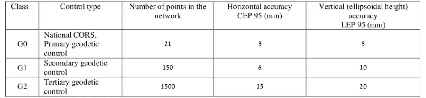
Table 1: Accuracy classes for horizontal control network surveyed by the Survey of Israel
Class Control type Number of points in the network
Horizontal accuracy CEP 95 (mm)
Vertical (ellipsoidal height) accuracy
LEP 95 (mm)
G0
National CORS, Primary geodetic control
21 3 5
G1 Secondary geodetic
control 150 6 10
G2 Tertiary geodetic
control 1500 15 20
The new regulations have set uniform and countrywide accuracy requirements for all survey work as listed in Tables 2.
Table 2: Accuracy classes for horizontal control network surveyed by private surveyors or by the Survey of Israel
Class Control type Surveying method Horizontal accuracy CEP 95 (mm)
Vertical (ellipsoidal height) accuracy
LEP 95 (mm)
S0 Private CORS GNSS 15 20
S1 - GNSS 25 60
S2 - GNSS or using a total
station 35
None
3S
Not for boundary points
determination
GNSS or using a total
station 50
None
Figure 1: The primary horizontal control in Israel is a network of 21 CORS
Further details about occupation time, difference between survey stations and so on are provided by the Director General Instructions, these are comparable to Caltrans 2012.
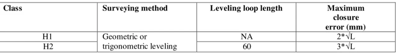
Unlike the horizontal network, the principles of the vertical network have not been changed. Initially, it was proposed that the vertical network should be based on the CORS network along with an official geoid model (Steinberg and Even-Tzur, 2006). Nonetheless, while it was agreed that in the future, the vertical network will be based on GNSS technology, it seemed that the currently GNSS technology with geoid undulation modeling does not meet accuracy standards for construction and civil engineering. Thus the national horizontal control is a network with two classes which was surveyed by geometric leveling with accuracy requirement (relative accuracy) as listed in Table 3.
Table 3: Accuracy classes for national vertical control network surveyed by the Survey of Israel
Class Surveying method Leveling loop length Maximum
closure error (mm)
H1 Geometric or
trigonometric leveling
NA 2*√L
H2 60 3*√L
Lower level vertical networks are divided into 4 classes as listed in Table 4.
Table 4: Accuracy classes for vertical control network surveyed by private surveyors and by the Survey of Israel
Class Surveying method Leveling GNSS
Ellipsoidal height accuracy
LEP 95 (mm) Leveling
segment length
Leveling loop length
Maximum closure
error (mm)
H3 Geometric or
trigonometric leveling 2 24 10*√L NA
H4 Geometric or
trigonometric leveling or using GNSS
technology
2 10 20*√L 10
H5 2 5 30*√L 20
H6 1 4 60*√L 40
3. CADASTRAL REGULATIONS
The current cadastral system in Israel was established in 1926 by the British mandate of Palestine, and is based on the Torrens principles (registration of titles). The country’s registered area, which includes 21,000 square km (about 5% of the area still is not registered), was divided into approximately 15,000 registration blocks; each contains an average of 50 parcels (about 750,000 parcels). Each block was assigned a unique number and was surveyed and drawn on a parcel map, along with a table of areas and parcel numbers. Surveying measurements and field notes were generally recorded in field books. The methods and the accuracies in which the boundaries were defined were heterogeneous. In some areas the boundaries are accurate to within a few centimeters but in some areas the boundaries are poorly defined and can be estimated to one or two meters accuracy.
Thus, every modification of land division (cadastre) requires massive amount of work that include the search and identification of the original boundary monuments, the reconstruction of the obliterated monuments, the establishment of the correct boundary lines, the design of the new division and the submission of a subdivision plat. Since there are about 1400 land modification (subdivision plats) every year, this process had to be improved.
The new Survey Regulations aim at improving the cadastral process by the following means:
1. Transform the Cadastral process from a paper based and manual one to a digital workflow enhanced by internet technologies (Felus et. al 2013). The new regulations do not require the submission of paper maps, paper field books but prefer digital maps signed digitally using digital signature technology and electronic field books and
calculations submitted using electronic portal according to standard computer formats and protocols.
2. Accurate and country wide consistent surveying procedures, which are based on GNSS technology. The new regulations require that boundary point coordinates will be determined to an accuracy of 5 cm (CEP 95) using the Israel CORS network (G0, as shown in Table 1). 3. Developing the Boundary Documentation Plat (BDP),
an instrument that will provide planners, architects and designers with accurate boundary coordinates. The BDP coordinates will be served as an accurate framework to support modern design procedures. Moreover, since the new planning zones will be based on approved and accurate boundaries, the conversion of the planning zones to subdivision plats is direct which will expedite registration.
4. Defining the National Cadastral Database (NCDB) as the dominant source of Cadastral information, this NCDB will be the only source in the future. Currently, Cadastral information is retrieved from a variety of heterogeneous resources including Block maps, field book, technical description, subdivision plats, existing monuments, land surveying etc.
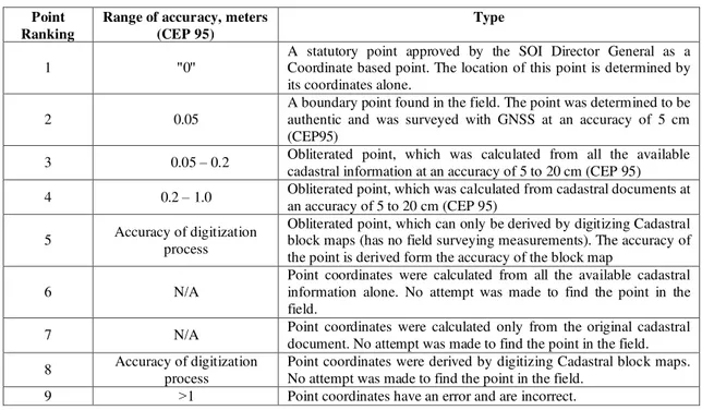
Table 5: Boundary point ranking
Type Range of accuracy, meters
(CEP 95) Point
Ranking
A statutory point approved by the SOI Director General as a Coordinate based point. The location of this point is determined by its coordinates alone.
" 0 " 1
A boundary point found in the field. The point was determined to be authentic and was surveyed with GNSS at an accuracy of 5 cm (CEP95)
0.05 2
Obliterated point, which was calculated from all the available cadastral information at an accuracy of 5 to 20 cm (CEP 95) 0.05 – 0.2
3
Obliterated point, which was calculated from cadastral documents at an accuracy of 5 to 20 cm (CEP 95)
0.2 – 1.0 4
Obliterated point, which can only be derived by digitizing Cadastral block maps (has no field surveying measurements). The accuracy of the point is derived form the accuracy of the block map
Accuracy of digitization process 5
Point coordinates were calculated from all the available cadastral information alone. No attempt was made to find the point in the field.
N/A 6
Point coordinates were calculated only from the original cadastral document. No attempt was made to find the point in the field. N/A
7
Point coordinates were derived by digitizing Cadastral block maps. No attempt was made to find the point in the field.
Accuracy of digitization process 8
Point coordinates have an error and are incorrect. 1
< 9
This new ranking allows efficient management of cadastral data at boundary point's level resolution. It also allows using different measures to treat boundary points with different quality.
The key concept underlying the table is that a point at rank 1 are legally determined by it coordinates alone. Any other contradicting evidence is inferior to the coordinates values. These regulations presents a major step towards Coordinate Based Cadastre, which will pave the way to a multi-dimensional cadastre, and to an overall more efficient Cadastre.
4. MAPPING AND GEOSPATIAL INFORMATION REGULATIONS
The field of mapping and Geospatial Information is consistently changing with new concepts and technologies making it impossible to set comprehensive regulations that will be valid for long time. Thus it was decided that the regulations will cover the basic definitions of mapping products and principal quality requirement and will not describe to the details of the technological procedures. The Director General Instructions are more dynamic and will be modified to follow technological changes. The three most important concepts that set the framework for the new regulations in mapping and Geospatial Information were: digital environment and metadata, sound quality control procedures and enabling emerging technologies and advanced mapping products.
4.1 Digital environment and metadata
The new regulations recognize the need to move away from paper maps with legend and specified scale to a digital spatial database (map) with metadata and specified quality parameters. Each digital spatial database should be provided according to the Director General Instructions, which specify the layer structure, attributes fields, table relationships etc. and with a
Metadata file. The Metadata file structure is specified in the Director General Instructions which are comparable to the ISO19115 standard.
4.2 Quality control procedures
The new regulations puts emphasis on modern quality control procedures, which are based on the ISO19157 principles and quality components. The six quality components are: logical consistency, positional accuracy, completeness, thematic accuracy, temporal accuracy, and usability. The Survey Regulation describe the detail requirements for the first four quality components, the last two components are used only rarely for unique projects.
A. Logical consistency – describe the fidelity of the relationships in the data set and the level of conformance to the required computer format. The dataset is automatically tested to see that it meets the computer format, otherwise it is rejected. In addition, automated software checks are carried out to evaluate the logical consistency parameter, for example:
Within a thematic layer - topological rules (e.g., search for overshoots or undershoots),
Domain rules for database fields and attributes (e.g., elevations cannot be smaller than -1000 m ) Between proper thematic layers (e.g., unreasonable
intersection of building layer with road layer)
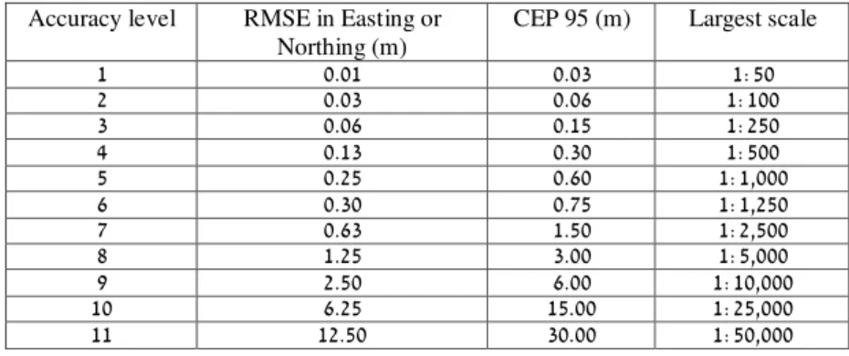
Table 6: Accuracy levels for mapping (horizontal)
Accuracy level RMSE in Easting or Northing (m)
CEP 95 (m) Largest scale
1 0.01 0.03 1:50
2 0.03 0.06 1:100
3 0.06 0.15 1:250
4 0.13 0.30 1:500
5 0.25 0.60 1:1,000
6 0.30 0.75 1:1,250
7 0.63 1.50 1:2,500
8 1.25 3.00 1:5,000
9 2.50 6.00 1:10,000
10 6.25 15.00 1:25,000
11 12.50 30.00 1:50,000
Table 7: Accuracy levels for mapping (vertical)
Accuracy level Spot height Elevation at well-defined point
Contour line interval (m) RMSE (m) LEP95 (m) RMSE (m) LEP95 (m)
1 0.01 0.02 0.02 0.04 0.05
2 0.02 0.04 0.03 0.06 0.10
3 0.05 0.10 0.08 0.15 0.25
4 0.10 0.20 0.15 0.30 0.50
5 0.20 0.40 0.30 0.60 1.00
6 0.25 0.50 0.38 0.75 1.25
7 0.50 1.00 0.75 1.50 2.50
8 1.00 2.00 1.50 3.00 5.00
9 2.00 4.00 3.00 6.00 10.00
10 5.00 10.00 7.50 15.00 25.00
11 10.00 20.00 15.00 30.00 50.00
Table 8: Ground resolution for digital images (used in mapping and for ortho imagery)
C. Completeness – Is information about omissions, commissions and selection criteria within the data set. The new regulations specify the exact ground resolution of images and orthophotographs used for mapping at different levels, see Table 8.
With this limiting resolution, the regulations specify two selection criteria for the completeness parameter:
Every permanent object which cover an area greater than 36 time the ground resolution (at Table 7) should be mapped as a matter of routine.
The Digital Terrain Model should include a breakline in every surface alteration larger than half the contour interval specified in Table 6
Tests for to evaluate completeness are specified in the Director General Instruction and are carried out either by performing duplicate surveys by two different mapping organizations or by superimposition of the vector map on the screen with the raster image of the aerial photograph. Results will be reported in the same manner specified by ISO 19157
D. Attribute Accuracy – is an assessment of the accuracy of the identification of entities and the assignment of attribute values in the data set.
This parameter is highly coupled with attribute accuracy because they have similar tests. Results will be reported in the same manner specified by ISO 19157
4.3 Enabling emerging technologies and advanced mapping products
One of the goals of the new wiregulation is to encourage the use of more efficient mapping procedures and technologies to produce more advanced mapping products.
Some of the latest mapping technologies include digital cameras (on satellites, aerial, on UAV's or on terrestrial systems), LIDAR, radar, mobile mapping systems. The regulations permit the use of any technology given that it was certified by the SOI as one that meets the quality requirements of a specific mapping level. Thus the regulations require that the SOI set up a certification program to test different sensors, and different combinations of integrated mapping platforms.
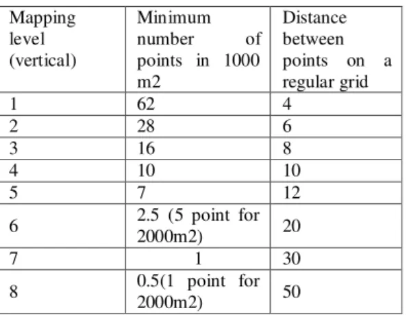
The regulation aims also at defining advanced mapping products that will be used to facilitate varying business activities (planning, design, construction, facility management, and more). Some of these include traditional products such as: Digital Elevation Model (DEM) - a regular grid of ground
points with spot heights, with density as described in table 9.
Digital Terrain Model (DTM) – a DEM with natural and artificial breaklines of the ground
Digital Surface Model (DSM) – a DTM with spot heights, elevation and breakline of earth's surface with all objects on it properly represented (building will have a rooftop breaklines as well as ground footprint breaklines).
Accuracy level 3 4 5 6 7 8 9
Table 9: Density of a DEM
Mapping level (vertical)
Minimum number of points in 1000 m2
Distance between points on a regular grid
1 62 4
2 28 6
3 16 8
4 10 10
5 7 12
6 2.5 (5 point for
2000m2) 20
7 1 30
8 0.5(1 point for
2000m2) 50
Moreover, the regulations define a 3D models as a mapping product, and specify it very similar to the OGC 2008 standard.
5. CONCLUSIONS AND FURTHER WORK
The new Survey Regulations form the framework for more efficient geodetic, cadastral, mapping and GIS working procedures in Israel. This framework will be used as the basis for the Director General Instructions, for guidelines to certify surveying and mapping equipment, for specifications in geo-information projects and so on. It is just the beginning.
In addition to publishing the regulations, the SOI is planning to develop a training campaign to make sure that the every professional understand the regulations and how to implement them.
Finally these regulation instigates the development of computer systems to support the new quality control requirement, and the development of regulations in related professional fields for example civil engineering, planning, valuation etc.
6. REFERENCES
Andreasson K. (2006) Legal Coordinated Cadastres – Theoretical Concepts and the Case of Singapore, Shaping the Change, XXIII FIG Congress Munich, Germany, October 8-13, 2006 at:
http://www.fig.net/pub/fig2006/papers/ts69/ts69_02_andreasson _0590.pdf
ASPRS (1989), ASPRS Accuracy Standards for Large Scale Maps,Photogrammetric Engineering and remote Sensing at: http://www.asprs.org/a/society/committees/standards/1990_jul_ 1068-1070.pdf
Bruce Joffe (2004), Implementing the NCEES Model Law for Surveyors and GIS Professionals, ESRI User Conference paper No. 1571 at:
http://proceedings.esri.com/library/userconf/proc04/docs/pap15 71.pdf
Caltrans (2012), Survey Manual, by the California Department of Transportation chapter 6, Global Positioning System (GPS) Survey Specifications at:
http://www.dot.ca.gov/hq/row/landsurveys/SurveysManual/06_ Surveys.pdf
ISO/FDIS 19157, Geographic information -- Data quality at: http://www.iso.org/iso/catalogue_detail.htm?csnumber=32575
Klebanov M., Felus Y., Fabrikant Y., Hodorov S.,(2009) Establishment of Coordinate Based Cadastre in Negev Desert, FIG Working Week 2009, Eilat, Israel, 3-8 May 2009 at: http://www.mapi.gov.il/UsefulInfo/MapiPublications/fig2009_k lebanov_etal_3257.pdf
OGC (2008), Open Geospatial Consortium, OpenGIS City Geography Markup Language (CityGML) Encoding Standard at: http://www.opengeospatial.org/standards/citygml
Steinberg G. (2001), Implementation of Legal Digital Cadastre in Israel. FIG Working Week 2001, Seoul, Korea 6–11 May 2001 at: http://www.fig.net/pub/proceedings/korea/full-papers/session10/steinberg.htm
Steinberg G. (2006) New Survey Regulations for Israel, XXIII FIG Congress, Munich, Germany, October 8-13, 2006 at: http://www.fig.net/pub/fig2006/papers/ts79/ts79_02_%20steinb erg_0306.pdf
Steinberg G. and Even-Tzur G. (2006) Permanent GNSS Networks and Official Geoid Undulations Model as a Substitute for Orthometric Control, Shaping the Change, XXIII FIG Congress Munich, Germany, October 8-13, 2006 at:
http://www.fig.net/pub/fig2006/papers/ts03/ts03_07_steinberg_ eventzur_0382.pdf
Jürg Kaufmann (2010) The New Swiss Law on Geoinformation and the Ordinance on the Cadastre on Public Law Restrictions (4064), FIG Congress 2010, Sydney, Australia, 11-16 April 2010 at:
http://www.fig.net/pub/fig2010/papers/ts07k/ts07k_kaufmann_ 4064.pdf
Srebro H. (2009) A Status Report of the Activity of the Survey of Israel, FIG Article of the Month at: