www.geogr-helv.net/70/239/2015/ doi:10.5194/gh-70-239-2015
© Author(s) 2015. CC Attribution 3.0 License.
Sight lines, sight areas and unbroken open spaces?
More-than-representational conceptualisations in
Dutch landscape planning
M. Bulkens, C. Minca, and H. Muzaini
Cultural Geography Group, Wageningen University, P.O. Box 47, 6700 AA, Wageningen, the Netherlands
Correspondence to:C. Minca ([email protected])
Received: 20 January 2015 – Revised: 14 July 2015 – Accepted: 21 August 2015 – Published: 11 September 2015
Abstract. Drawing on the case study of the Wageningse Eng, the Netherlands, this paper examines a set of spatial metaphors (and their attendant grounded impacts) employed within two key policy documents – the allocation plan and a related map – pertaining to how the cultural landscape is to be spatially managed and developed by the municipality. Although promoted as being based on historical facts and a cornerstone of Dutch commitment to participatory planning, the case being studied reveals the ways in which these metaphors are at times not only entirely subjective and arbitrary, but also perceived by residents and users as neglecting their rights with respect to the landscape and as instruments constraining what can or cannot be done in that area. More broadly, in the face of calls for more non-representational approaches to landscape analysis, the paper shows the continued salience of representational practices within spatial planning and how these may hold very material implications for landscapes.
1 Introduction
On 30 July 2012, “De Veluwepost”, a local newspaper of Wageningen, a town of about 37 000 inhabitants located just north of the river Rhine in the Dutch province of Gelderland (Gemeente Wageningen, 2012c), reports that, by order of the municipality, a walnut tree of 25 cm in diameter had to be eliminated from the landscape following a neighbour’s com-plain that it was “blocking the view out of her window”. The decision to cut the tree was announced by the alderman – second in command after the mayor, and responsible for spa-tial planning in Wageningen – with the claim, according to the newspaper, that “the allocation plan states that the Eng should be open. Trees are just not allowed” (Boer, 2012).
This episode provides a useful and provocative entry point into examining how the Wageningse Eng, a former agricul-tural area of 595 acres in size, located at the east side of the municipality, has become the subject of controversy over its development plans. The specific “tree incident” in fact coin-cided with a period in which the municipality was in the pro-cess of determining a new plan aimed at defining the legally binding rules for future spatial developments in the whole
by groups or individuals with vested interests on the ground. More broadly, it takes inspiration from Lorimer’s more-than-representational approach (2005) in terms of reflecting upon the continued salience of representational practices and their attendant consequences within society (see, among others, Anderson and Harrison, 2010). Indeed, even as scholars have criticised the “deadening” effect of representational practices (Lorimer, 2005) this paper argues that, at least in Wagenin-gen and possibly in the Dutch context at large, “represen-tational practices” remain key in how power is manifested through particular ideas about and conceptualisations of the landscape.
Following a brief review of recent theoretical shifts within cultural geography, we shed some light on specific features of participatory spatial planning in the Netherlands. This is dovetailed by a description of the case study area and of the methods adopted in the research, alongside introducing the spatial allocation plan for the environs of Wageningen and the above mentioned map produced by the TAWE. Particular emphasis is placed on how spatial/geographical metaphors – such as “open fields and spectacular views”; sight lines; and, to a lesser extent, sight areas and perspectives – have been utilised towards justifying specific practices within the Wa-geningse Eng. Drawing upon a series of in-depth interviews, the paper then demonstrates how these landscape conceptu-alisations and representations – as maintained by the two key texts here examined – are indeed perceived as “obvious” and “historical” by some, and as “undesirable” and “arbitrary” by others. Based on the findings, the conclusion first stresses how representations still matter a great deal in the crafting not only of ideas about the related landscapes, but also of the material geographies and the spatial practices those ideas may produce when mobilised to become part of a devel-opment plan for specific areas. Secondly, it highlights the ways in which, despite well-established discourses present-ing Dutch spatial plannpresent-ing as a fundamentally democratic process involving long and extenuating negotiations among the residents and the decision makers (Evers, 2008; Need-ham, 2007; Hagens, 2010), public debates about the nature and the management of landscapes, in Wageningen, and pre-sumably elsewhere in the Netherlands, are undermined by the workings of specific representations of landscapes deliv-ered by “top-down documents”. In Wageningen, despite be-ing the result of widely recognised (and formalised) partici-patory processes, plans are importantly influenced by a spe-cific set of landscape ideologies and by their related more-than-representational “power”, which impact on the real and imagined spatialities of the Wageningse Eng.
Towards a “more-than-representational” conceptualisation of landscape
As a concept, “landscape” has become the indelible “lens” for many cultural geographers trying to make sense of the in-teractions between individuals and their environment (Wylie,
2007; see also Minca, 2007a). Following the “cultural turn” of the late 1980s, under the umbrella of what was referred to as “new cultural geography”, the main focus has been on the analysis of (elements of) landscapes not only as physical manifestations in the world but also as being highly sym-bolic and profoundly ideological in terms of the meanings imputed within, or projected through, them (Cosgrove and Jackson, 1987; Duncan and Ley, 1993; Mitchell, 2000, 2001, 2002; Cosgrove and Daniels, 1988; Cresswell and Verstraete, 2003; Minca, 2007b). Far from being reified and necessar-ily accepted, however, these meanings are often contested by others with different ideas of how landscapes should look and what they should represent: a defining framework adopted by many scholars interested in studying the representational pol-itics of landscapes (Wylie, 2005, 2007; Minca, 2007b). Yet such an approach has subsequently also been critiqued as ne-glecting the natural, material and embodied aspects of land-scapes, and how these affectively and emotionally relate to people. Drawing on the Heideggerian concept of “dwelling”, which refers to anactiveengagement with the material world as “a meaningful place for people through being lived in”, anthropologist Ingold (2000:168) highlights how cultural ge-ographers have over-emphasised the representational facets of landscapes (what they mean or what they represent) at the expense of considering the materiality of landscapes and how individuals immanently “engage” with these and are conse-quently impacted upon by them (see also McHugh, 2009).
from Crouch’s (2000, 2003) research on encounters and em-bodiment in leisure and tourism via the study of caravanning and allotment gardening, to Dewsbury’s (2000) and Harri-son’s (2000) discussion of the relationship between embodi-ment and space, to Lorimer’s writings on learning geography (2003) and herding (2006), as well as to Wylie’s (2005) re-flections on walking.
One problem with the non-representational approach, however, is that it all too often underplays the fact that, in many spheres of life, landscapes are still viewed and treated “representationally”, with a strong emphasis placed on the set of meanings that make them up and/or that they have been engineered to project (Lorimer, 2005). This is espe-cially the case in the context of the work on/in landscape planning and participatory politics (Cadman, 2009). Hillier (2007), for instance, uses the term “post-representational” to argue that planning practices still largely revolve around representations, particularly representations of planning ar-eas captured within visual texts such as plans and maps. She indeed maintains that in “planning practice” these represen-tations are all too often taken for granted as natural, hege-monic and absolute truths of the world out there, “rather than reflecting the multidimensional, often conflicting repre-sentations which coexist in reality” (Hillier, 2007:195). She also argues for a much-needed step back to reflect upon the coming about of these representations, upon how these affect planning practices, and how they may be contested. A simi-lar claim is made by Healey, suggesting that the “analysis of the nature of concepts of place and space being deployed” is a less-developed field of planning studies, while these con-cepts have a performative capacity in shaping the actual spa-tial developments of areas (2004:46; also 2002). This seems especially relevant when it is recognised that “policymakers and planners [do not] care much about lived schemes of sig-nification” (Plłger, 2006:393).
The present article thus touches upon these debates within cultural geography and spatial planning by exemplifying the still-dominant position of landscape representations (com-pared to people’s everyday landscape practice) in one illus-trative case of local Dutch spatial planning, as well as en-gaging with the complex entanglements of representations and meaning in planning as not only ideological and hege-monic but also polyvocal and contested. Further, to consider the non-representational aspects of landscape (i.e. the prac-tices that constitute it) does not necessarily imply that ques-tions of intended meaning and the resulting (often contested) interpretations become unimportant. In fact, as Dewsbury et al. (2002:438) have argued, we should perceive representa-tions “not [only] as a code to be broken or as an illusion to be dispelled, [but] rather representations [should be] ap-prehended as performative in themselves; as doings”. The focus, therefore, should be on the act of representing it-self, an act that does not solely communicate a message – which may either be accepted or resisted (hence lending to contestation or negotiation) – but an act capable of
chang-ing and transformchang-ing individuals and their surroundchang-ings. Ac-cordingly, landscapes may therefore be seen as representa-tional not only in terms of what “they mean” but also in terms of what they “do” to people’s everyday practice. It is in line with this thinking that Lorimer (2005) introduces the term “more-than-representational”, a term that allows landscapes to be understood and studied not only for what they repre-sent but also for how they are performed towards real im-pacts (see also Anderson and Harrison, 2010). In this regard, landscapes thus become also active agents in themselves and not merely the end product of human actions and cognition, as conceived before under the auspices of new cultural geog-raphy.
2 Methods
The contemporary political and social climate in the Nether-lands has often been described as embracing the values of compromise and consensus building, a philosophy that ex-tends to the ways in which spatial planning is carried out in the entire country today (Evers et al., 2008; Hagens, 2010). Spatial planning scholar Barrie Needham (2007), studying land use planning in the Netherlands, famously traces this back to the “polder model” adopted in Dutch history, when water boards – governmental bodies maintaining the water system and safeguarding water safety – were created before any other form of public administrative body. Given the au-thority by the citizens to manage and maintain the polders, the water boards applied a deliberative process which medi-ated the interests of landowners and land users towards find-ing consensus or, when impossible, an acceptable compro-mise. This strategy, and “philosophy” behind it, soon spread as a way of managing public life, including that of spatial planning carried out in the entire country. Such an arguably “inclusive” approach, however, is not devoid of problems. For Needham (2007) it may produce “grey compromises” or, even worse, “lowest common denominator solutions”, thus making Dutch spatial planning “viscous” and “sticky”. Sim-ilarly,Habiforum(2003) – an influential network of profes-sionals in spatial planning and area development – describes issues pertaining to the management of conflicts of interest as among the major challenges faced in the past decades by spatial planning in the Netherlands. Even so, as part of broader processes in which citizens and non-governmental organisations are, at the local level, able to participate in decision-making processes (Van Assche, 2004), ideas such as “consultation” and “cooperation” between different groups remain key to the ways in which landscapes in the Nether-lands, including the Wageningse Eng, are planned (Need-ham, 2007:35).
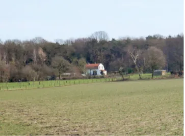
Figure 1. The Wageningse Eng, south side, photo by Maartje Bulkens.
years, however, the actual use of the Eng for agricultural purposes has been rather limited given its unprofitability, re-sulting in recreational and residential uses becoming more dominant. These include horse keeping, allotment gardening, small-scale biological farming, flower-picking gardens, and the cultivation of trees and plants (see Fig. 1) (Renes, 1993; Gemeente Wageningen, 2012a, b).
To manage such a variety of vested interests in the area, and in favour of public participation in spatial planning, for-mal organisations have emerged. In 2009, for example, the “Stichting Wageningse Eng” (SWE) was established to
stimulat[e] the maintenance and, where possible, the improvement of the natural landscape and cul-tural historical values of the Eng, as well as the development and facilitation of new sustainable forms of [land] use at and in favour of the Eng (Stichting Wageningse Eng, 2012; translation by authors).
In order to keep the diverse tasks of the foundation distinct, three subcommittees were created: the executive committee, the advisory committee and the TAWE. The executive com-mittee is responsible for managing the foundation and repre-senting the many different interests in the area. The advisory committee – composed of members with different stakes in the area, including residents, recreational users, users, etc. – provides the foundation with solicited and unsolicited advice. Finally, the TAWE was appointed by the mayor and the Al-dermen to garner advice on matters pertaining to the granting of licenses, municipal spatial development policy, and any other issues related to the landscape of the Wageningse Eng (Stichting Wageningse Eng, 2012).
Other involved associations areMooi Wageningen (Beauti-ful Wageningen), constituted by individuals concerned with the protection and preservation of “irreplaceable values of the surrounding nature and landscape of Wageningen” (Mooi
Wageningen, 2012), and theVereniging van Gebruikers en Eigenaren van de Wageningse Eng(Association of Owners and Users of the Wageningse Eng, now disbanded), made up predominantly of residents and users of the area who want more opportunities to participate in the spatial development at the Wageningse Eng.
Our fieldwork took place mainly in June 2012 in the weeks immediately following the release, on the part of the munic-ipality of Wageningen, of the “predesign”, a provisional de-sign opened to initial public discussion leading to the crafting of the official final design of the allocation plan. During this period, 15 “narrative interviews” (Jovchelovitch and Bauer, 2000), each lasting between 1.5 and 2.5 h, were conducted, in which interviewees were invited to narrate their own im-pressions of the Wageningse Eng and their views pertaining to the forging of the new allocation plan. Seven of these were with residents of the sparsely populated area, and eight with representatives of organisations that have played important roles in the actual planning processes. To consider the role of the municipality itself, we also interviewed the alderman. While not meant to be generalisable, this sampling has in-deed allowed us to capture the diversity of stories related to the process of establishing the new allocation plan, and about spatial planning processes at the Wageningse Eng more gen-erally. Because of the direct involvement of the interviewees in the projects examined here, only pseudonyms are used. These interviews were first coded and mined for relevant themes that emerged, and further supplemented by an analy-sis of policy documents and publicly available commentaries published during the period, which provided data on “polit-ical” processes at the Eng in relation to the allocation plan. Central to these interviews were ideas promoted/presented by the allocation plan and “the map”, to which we now turn.
The forthcoming Wageningen allocation plan and TAWE map
Dutch spatial plans are produced at different levels of gov-ernment: national, regional/provincial, and local/municipal. However, only the local/municipal allocation plan has di-rect legal consequences for citizens (see, for example, van der Valk, 2002). As a consequence, any decision to build or change a particular land use requires a permit granted by the municipality, which is evaluated on the basis of the alloca-tion plan. Indeed, the municipality is obliged to grant per-mits when the applications conform to the current plan. For rural areas the implementation of an allocation plan is com-pulsory, while for urban areas this is optional (van der Valk, 2002; Needham, 2008).
Wageningen met this requirement at the end of September 2013, when the renewed allocation plan was officially de-cided upon by the municipal council. The new legislation clearly prescribes the procedure to be followed when deter-mining a new allocation plan. Municipalities are obliged to give public notice of these very procedures through the lo-cal media, the Staatscourant, and on the Internet. Owners of land parcels included in the area in question must be ade-quately informed. In the definition of an allocation plan in the Netherlands there are two defining moments of participation for residents. The first is optional and determined in its for-mat by each municipality independently. This takes the form of a predesign. After publishing its predesign, the Wagenin-gen municipality received 55 public comments concerning the future allocation plan, 28 of which about the Wageningse Eng (Gemeente Goes, 2012; Gemeente Wageningen, 2013; deWro, 2013).
The second crucial moment of “public participation” nor-mally takes place after the first draft of the allocation plan has been completed. This is then made public both in print (for example through the local newspapers) and electroni-cally through the national website reporting all legal spatial plans of the Netherlands, a prerequisite so as to allow citi-zens to express again their views. Municipalities are legally obliged to facilitate this. This is how the Wageningen munic-ipality announced their new plan:
Content-wise there are no major changes in the new allocation plan compared to the current one: the plan is conservative in character. Because of the general standardisation of the plan set-up there may be differences in some of the details. (Staatscourant, 2013; authors’ translation).
Citizens can express their views on the document either verbally or in written form, but this must be done within a specific time frame, in order to be able to later lodge an appeal to the determined plan in which a change in alloca-tion or condialloca-tions is applied. Within 12 weeks after the end of the period of public consultation, the municipal council digitally determines the allocation plan (deWro, 2013). In the Netherlands, the legal plan is a digital plan and not a hard copy (interview of the alderman of Wageningen mu-nicipality, 19 October 2012). The plan consists of three main components: the official design; the accompanying explana-tion; and the rules describing what is allowed and what is not within particular allocations. It is beyond the scope of this paper to fully examine the rules applied to the Wagen-ingse Eng (see www.ruimtelijkeplannen.nl for the full plan), although, where necessary, references to these will be incor-porated in our discussion. For instance, it is perhaps useful to report how the conceptualisation of the Eng is given in the accompanying explanations:
In the past, engendeveloped at the flanks of the Veluwe. Engen are old agricultural areas charac-terised by anunbroken open area, surrounded by
plants and buildings with small-scale parcelling and cultural historical landscape elements. [...] Due to the differences in height [...]very striking viewscan be enjoyed in the urban area, the forest area, and the Eng itself. (Gemeente Wageningen, 2012b:26; authors’ translation; emphasis added).
In the current allocation plan the area is defined as a “city edge area with special landscape val-ues” [...] One of the basic principles is that of structurally preserving and improving the Eng as a landscape with rich land variations and anopen character. The current rights of use will be main-tained. Relevant area zoning, with respect to al-lotment gardens and equestrian sports, are adopted in the allocation plan. [...] New developments are not allowed in the area. (Gemeente Wageningen, 2012b:26; authors’ translation; emphasis added)
Within the allocation plan, no further specifications were made with regards to what terms like “unbroken open area” or “striking views” actually meant, although the second key “text” – the sight areas, sight lines and perspectives map, produced by TAWE – attempts to visually capture precisely these. Due to the way in which spatial planning is organised in the area, the map has thus become a specific representation of what both terms entail.
role in the spatial development of the Wageningse Eng, es-pecially in granting permits (TAWE member, personal com-munication, 13 September 2012). The map has become, in practice, a powerful representation of the Eng landscape due to the TAWE making use of it when advising the munici-pality. The rest of the paper will thus turn to the different and conflicting ways in which unbroken open area as well as sight lines, sight areas and perspectives are interpreted, despite their prominence in the official documents in charac-terising (and shaping) the Wageningse Eng landscape. More specifically, we will show how representations and textual conceptualisations of the landscape continue to play an im-portant role in local spatial planning, also in terms of how the material landscape is actually managed and developed.
3 Results
3.1 Dissonant interpretations of unbroken open areas According to the predesign of the allocation plan (Gemeente Wageningen, 2012b), an eng is defined as an unbroken open area, which pertains to the idea that the Wageningse Eng has historically been very much an “open” landscape. This view is also echoed by Mr Allen, a member of Mooi Wageningen, although the real extent of this “openness” remains uncertain:
from that history you look at the landscape then it would be nice if in that landscape the histor-ical characteristics remain recognisable, thus that openness is in that sense important. Then you im-mediately get into discussions about how open it should be, [...] and what kind of sight lines do you need.
This notion of openness is also often mentioned by other respondents when asked to reflect upon the historical devel-opment of the Eng. For the alderman,
considering the structure, it has been reasonably open the last period, 25, 40 years, and it has actu-ally always been like that, except for periods when the crops were growing, but that is of course only one part of the year.
The alderman’s description here is temporally qualified, referring to how the Wageningse Eng has not always been as open as it is today, since “there was tobacco grown for a while, and then it gradually but surely remained an open area with some small-scale agriculture and cultivation”. This in-dicates how, contrary to what is stated in the allocation plan, the Eng was not always an “open area” despite the fact that, in the last decades, it has become more so.
The conceptualisation of the Eng as an open landscape may perhaps be attributed to a longing for the “museumifi-cation” of the landscape, a process in which the landscape is represented as a still frame, to be preserved in its present form, thereby denying the possibility of change, now and in
the future, as declared by Mr Hall, former member of the Association of Owners and Users of the Wageningse Eng:
But if one perspective about the Eng becomes dominant, namely the Eng as a beautiful cultural landscape, that should predominantly be main-tained, that should remain open [...] the Eng is an area which is used in many different ways by the urban population of Wageningen, let us steer it in the right direction, let us applaud that, and not with a long face of the sight line.
All too often interviewees refer to how the definition of the Eng as an “open landscape” denies many of the current uses of the area. In her public comment to the predesign, the owner of one of the flower-picking gardens makes a plea to gain permission to create new facilities on her terrain, like a shelter; a toilet; a covered wagon; and the possibility of selling coffee, tea and sodas to the general public. She also claims that the TAWE agreed on these plans. However, in the formal response to this request, the municipality states that the TAWE never agreed upon these plans, and that they had to be turned down for not fitting in with the conservative char-acter of an open eng. By representing the Wageningse Eng as an open landscape, therefore, many potential land uses are inhibited.
This could be traced back to the tendency in Dutch land-scape planning for the eschewing of elements that may be seen as disturbing the “unity” of the Eng (Coeterier, 1996), such that the new additions were seen as unnecessary dis-ruptions to the overall coherence of the landscape as a vi-sually open space, even as this was never always the case. Here, therefore, a specific set of representations incorporated in the allocation plan have had a deadening effect on the land-scape, in line with Healey’s (2002:1785) claims that “once an imagination is brought to life, it has material effects”, by defining particular restricted practices in/of that landscape, even if there seems to be no historical basis for sustaining such a view. This reflects how dominant representations of a landscape may be questionable in their rendering of the past. As argued by Graham and Healey (1999:641), often plan-ners tend to let the representations of “articulate and powerful groups” become dominant, and may reveal a potentially “per-formative” capacity where these representations also sym-bolise “acts” with real impacts on the landscape and its users. The interpretation of the Eng as an open landscape has also been criticised by other users on the basis of land-scape typologies normally adopted in the Netherlands. As Ms Wilkinson, member of the advisory committee avers,
Later she adds that the term also causes problems “because it offers people who want to get rid of boscages and sheds, all opportunity to say it does not fit in an open landscape [sic]”. Here again, the idea that, historically, the Eng has never been a totally open landscape emerges. More importantly, how-ever, this quote reflects upon how dominant representations of landscapes within official documents may be skewed in order to achieve particular objectives, in this case to “get rid of boscages and sheds” and prevent alternative spatial de-velopments. Hence, with the representation of the Eng as an open area, there is as a consequence also no room within the new allocation plan for shelter opportunities or larger storage spaces. It is not surprising therefore that the 16 public com-ments on the predesign requesting for the building of shelters or larger storage spaces were all neglected. This decision was justified by the conservative character of the new allocation plan, meaning that no changes were allowed, including no opportunities for further spatial developments. More impor-tantly, it highlights how such “conservative” conceptualisa-tions of the Eng, along with policy goals and the accompa-nying rules, decisively affect the materiality of the landscape (Coeterier, 1996).
Remarkably, the majority of public reactions concerning the Wageningse Eng were either rebutted or outright turned down for not fitting in the conservative character of the plan. Although the publication of the predesign was meant to en-courage public participation and ensure a sense of trans-parency in the process – the cornerstone of spatial planning in the Netherlands – it appears as if only comments in line with the already-shaped predesign were incorporated into the following stages. This very fact thus possibly questions the notion of public participation in Dutch spatial planning and the ways in which, at the local level, this may be incorpo-rated in practice into the decision-making process (see also Bulkens et al., 2014).
3.2 The performative power of the “sight lines, sight areas and perspectives” Map
Another example of how particular representations may have real effects on the material landscape is provided by the ac-counts provided by Mr and Mrs Evans, who have been long-time residents of the Wageningse Eng (see Fig. 3). In 2002, they participated in a project aimed at strengthening the “eco-logical structure” of the area by reintroducing “old” land-scape elements, and they signed a 10-year contract with the commission ofLandschapsbeheer Gelderland(2003) (Land-scape Management Gelderland), which is responsible for the implementation of this project. Specifically, they sought to bring back a standard tree orchard on their property, con-forming to the location of the orchard as captured by old aerial pictures of the area. Due to circumstances they post-poned the project. When they decided to proceed with the original plan they went on to plant eight standard trees. How-ever, reminiscent of the walnut tree incident mentioned at the
beginning of the paper, a neighbour lodged an objection to this. Even with the presence of a signed contract with Land-schapsbeheer Gelderland, the municipality declared the trees illegal. When the couple consulted the TAWE, they too came to learn that the trees were illegal for obstructing an “impor-tant” sight line (see Fig. 2). After a protracted debate, a com-promise was reached with the TAWE, leading to the removal of two trees perceived as blocking the sight line. This partic-ular dispute aside, what emerges here is again a discrepancy between historical conceptualisations of the landscape – in-cluding tree orchards, as shown by old aerial photos in the possession of Mr and Ms Evans – and other contemporary conceptualisations where the trees no longer have a place, as determined by the sight line rationale depicted by the TAWE. This is clearly reflected in the following quote by Mr and Mrs Evans on the turn of events:
Because the line of approach was to restore the old cultural elements in the landscape and the orchard also belonged to those as well as hedges. But of course it goes against the regulations of the munic-ipality, because woody vegetation is not allowed. Thus, those trees, that is woody vegetation, but it is also an element in the cultural landscape. A standard tree, we especially selected an old apple strain. [...] And they [Landschapsbeheer Gelder-land] say restore the cultural landscape but what moment of the past are you going to restore, right.
This raises the important question of which historical pe-riod should be taken as foundational when one speaks of “re-turning” to the landscape of the past, something that has clear implications for how the “right” landscape ought to be con-ceptualised and governed today. As our case shows, answers to this question potentially vary depending onwho speaks. Even so, formal sets of representations, as concretised by the map as much as by the forthcoming allocation plan, do seem to take precedence when material changes to the actual land-scape are involved, hence demonstrating the way in which formal plans are not only subjective but also instrumental in influencing real landscape production and practice, as these representations travel from the framing of policy to those who make the decisions on regulations and permits (Healey, 2002).
Figure 2.Sight lines, sight areas and perspectives map, source Territoriale Advies Commissie Wageningse Eng (2012, written permission translated by author’s.).
by the term sight line (as stated in the TAWE’s map) and how this led to the trees having been removed. This could per-haps be traced back to the specific type of landscape idyll in the Netherlands, which generally tends to emphasise scenic beauty and visual aesthetics over what it looked like before (see De Vries et al., 2012).
doc-Figure 3. Property of Mr and Mrs Evans, photo by Maartje Bulkens.
uments and maps, such as openness, sight lines, unbroken area and “very striking views” – hold real implications be-yond the representational; indeed, notwithstanding the his-torical foundations of these representations of the landscape, they have nevertheless led to actual material interventions in the landscape, such as the removal of trees. We would like to argue then that representations of the landscape, although contested, often remain important elements, or even ‘acts’, in shaping the materiality of the landscape: by being reiterated and reinforced in the planning process they gain the power to impact upon the landscapes and its residents and users. Landscape representations, in other words, maintain actual effects on the spaces where people live and with which they identify; or, at least, this is illustrative of the Wageningse Eng and possibly of many other Dutch cases.
This can indeed be interpreted as a plea for a more-than-representational approach to the landscape within spatial planning, in which the landscape is as much part of the pol-itics of representation, as it is of the daily spatial practice of the people gravitating around it. The performative power of the map in question, reflecting a representation of an ideal landscape made of sight lines and sight areas, is derived from the map gaining the status of a “regime of truth” (Harley, 1989; Woods, 1992, 2010), as Ms Turner’s, member of the SWE, comments suggest:
That sight line map, I do think that is rather special, that map gains a status of truth, but that is located in a sight line, and then I think like well we can see five meters on the other side of the sight line and half a meter on the other side we also still can see.
Mr Hall, former member of the Association of Owners and Users of the Wageningse Eng, even went as far as to make an analogy with religion when discussing the sight lines, which he refers to as “a new article of faith”; their arbitrariness notwithstanding, they are still perceived as the way to go:
[Name of a party] takes it extremely far in “noth-ing is allowed”, the Eng should remain open, and one building block of the fragile construction of the Wageningse Eng is absolutised, it is almost a religious something right.
The analogy with religion shows how this map is perceived by some as a sort of revealed “truth”.
Nevertheless, like the open character of the Eng, the notion of a sight line is also criticised:
[Y]ou always get a situation with each sight line map you create that on paper there is a line.. That has a kind of inherent rigidity and arbitrariness, be-cause you can draw the line of course a bit dif-ferent. (Mr Hall, member of former Association of Owners and Users of the Wageningse Eng)
[The map] where they only talk about sight lines, when I saw that ten years ago for the first time, really the piece was absolutely full of arrows im-plicating that everything was a sight line, yes that is not a sight line. (Ms Wilkinson, member of the Advisory Committee)
The most recent version of the map consists of 29 different elements (ranging from sight areas to sight lines to perspec-tives). The map is a clear example of how, although arbitrary in nature, since those very lines could indeed be drawn differ-ently, this representation of the landscape of the Eng creates the conditions for the actual implementation of future spatial developments in the area. As, again, Ms Evans puts it,
That [the sight lines] is really questionable, you see, you can debate about it. We agreed that the shed actually stands in a sight line. [...] We asked the opinion of a landscape architect, an indepen-dent person, and he said well those trees stand in the perfect place as they do now [...] because the trees of that neighbour over there those stand in the same line, and that reinforces the view. And in the past they also used to stand like this. But well for peace and quiet we decided to agree with the TAWE, like we want this to end, we just want it solved.
with it. The powerful impact of the sight lines, as determined by the map (and the sight areas and perspectives, although these were not analysed in detail in this paper for lack of space), is something that critically problematises the actual participatory nature of the planning process, at least in the cases here described. The TAWE, also thanks to its map, not an official document but a potent more-than-representational tool indeed, has gained a dominant and powerful position in its role as advisory committee, while the map itself has achieved the status of a regime of truth over the definition (and the management) of the Wageningse Eng landscape.
4 Discussion and conclusion
The Wageningse Eng has proven to be a useful example of how spatial planning, even in a country characterised by a long tradition of participatory practice like the Netherlands, may be affected by the more-than-representational power of some representations, and not others. In addition, the case here studied reveals how, while the traditional focus on the representational aspects of landscape may rightly be criti-cised by the literature on non-representational theory in ge-ography, at the same time representations remain powerful acts if employed in documents produced by institutions with the capacity of incorporating them as regimes of truth. This is precisely what we have tried to highlight in this paper by em-phasising the role played by spatial metaphors like the ones adopted within the two key documents here taken into con-sideration.
All in all, this paper has shown how, within spatial plan-ning practice – that is, the very “act of spatial planplan-ning” – the representational may still play a decisive role in con-ceptualising and “naturalising” – as the realm of the taken for granted – what should and should not be allowed within the landscape. Representations captured in plans and maps in the case here studied have indeed become key and powerful sources in the definition of the natural and historical voca-tion of that landscape, for example by presenting it as “open to spectacular views”.
Moreover, the representations of the (cultural) landscape of the Wageningse Eng – often based on certain “Dutch” ide-als pertaining to landscape coherence, visual aesthetics and unity, through being repetitiously articulated – have gained a performative power in affecting not only the materiality of the landscape but also the practicesofandwithin the land-scape, even if this does not necessarily correspond to the his-torical nature and character of that specific landscape. Ad Maas’ walnut tree was cut down for not fitting within the dominant institutional planning representation of the Wagen-ingse Eng, like those produced and circulated by the munici-pality and the TAWE.
However, this paper has also demonstrated how, despite the hegemonic affordances of such representations of the landscape, they do not always go uncontested. Their
histor-ical veracity aside, some of those who “practice” the land-scape on a day-to-day basis, such as residents and visitors, have also argued that a representation of the Wageningse Eng as an open landscape with spectacular views makes the ac-tual use of the Eng very difficult (if not impossible), implic-itly accusing the politics of representation inherent to the in-cumbent planning of creating a deadening effect (Lorimer, 2005:83; Cadman, 2009:1) on the landscape as a place to live, where to keep horses, practice gardening, etc. A plea for a more-than-representational or post-representational ap-proach to landscape planning practices thus allows for more attention to be paid to the actual practicesofandinthe Wa-geningse Eng landscape. This is particularly important in or-der to avoid “participation” becoming a mere pacifier term denoting a process of consensus building and cooperation, while actual decisions are made from the top down. If spatial planning is indeed aimed at being an inclusive participatory process of decision making, the more-than-representational role of some spatial metaphors like the one here analysed should be taken into full consideration, also for their impli-cation for the actual practice of landscape.
Acknowledgements. This research is part of the strategic research program KBIV, “Sustainable spatial development of ecosystems, landscapes, seas and regions”, funded by the Dutch Ministry of Economic Affairs and carried out by Wageningen University Research Centre. It was also funded by the Cultural Geography Chair Group at Wageningen University.
Edited by: B. Korf
Reviewed by: three anonymous referees
References
Anderson, B. and Harrison, P.: The promise of non-representational theories, in: Taking-place: non-representational theories and ge-ography, edited by: Anderson, B. and Harrison, P., Ashgate, Farn-ham, United Kingdom, 1–36, 2010.
Boer, J.: Kafkaiaanse toestanden op de Wageningse Eng, De Veluwepost, 2012.
Bulkens, M., Minca, C., and Muzaini, H.: Storytelling as method in spatial planning, Eur. Plan. Stud., published online 8 August 2014.
Cadman, L.: Nonrepresentational Theory / Nonrepresentational Ge-ographies, in: International Encyclopedia of Human Geography, edited by: Kitchin, R. and Thrift, N., Elsevier, Amsterdam, The Netherlands, 2009.
Coeterier, J. F.: Dominant Attitudes in the Perception and Evalua-tion of the Dutch Landscape, Landscape Urban Plan., 34, 27–44, 1996.
Cosgrove, D. and Daniels, S.: The Iconography of Landscape, Cam-bridge University Press, CamCam-bridge, United Kingdom, 1988. Cosgrove, D. and Jackson, P.: New Directions in Cultural
Geogra-phy, Area, 19, 95–101, 1987.
Crouch, D.: Places Around Us, Leisure Stud., 19, 63–76, 2000. Crouch, D.: Spacing, Performing, and Becoming, Environ. Plann.
A, 35, 1945–1960, 2003.
De Vries, S., de Groot, M., and Boers, J.: Eyesores in Sight: Quanti-fying the Impact of Man-Made Elements on the Scenic Beauty of Dutch Landscapes, Landscape Urban Plan., 105, 118–127, 2012. DeWRO: http://www.wetruimtelijkeordening.net/page.php?3, last
access: 30 May 2013.
Dewsbury, J.-D.: Performativity and the Event, Environ. Plann. D, 18, 473–496, 2000.
Dewsbury, J. D., Harrison, Rose, M., and Wylie, J.: Enacting ge-ographies, Geoforum, 33, 437–440, 2002.
Duncan, J. and Ley, D.: Introduction: Representing the place of cul-ture, in: Place/Culture/Representation, edited by: Duncan, J. and Ley, D., Routledge, London, United Kingdom, 1–21, 1993. Evers, D.: Reflections on territorial cohesion and European spatial
planning, Tijdschr. Econ. Soc. Ge., 99, 303–315, 2008.
Gemeente Goes: http://www.goes.nl/bestemmingsplannen/ procedure-bestemmingsplan_3760/, last access: 2 July 2012. Gemeente Wageningen: Reactienota Voorontwerpbestemmingsplan
Buitengebied, Gemeente Wageningen, Wageningen, The Nether-lands, 2012a.
Gemeente Wageningen: Voorontwerp Bestemmingsplan Buitenge-bied, Gemeente Wageningen, Wageningen, The Netherlands, 2012b.
Gemeente Wageningen: http://www.wageningen.nl/Ontdek_ Wageningen/Feiten_en_cijfers/Algemene_feiten_en_cijfers, last access: 6 May 2012c.
Gemeente Wageningen: Ontwerp Bestemmingsplan Buitengebied, Gemeente Wageningen, Wageningen, The Netherlands, 2013. Graham, S. and Healey, P.: Relational Concepts of Space and Place,
Eur. Plan. Stud., 7, 623–646, 1999.
Habiforum: System Innovation urban and regional land use and area development. Habiforum. Gouda, The Netherlands, 2003. Hagens, J. E.: The performance of landscape concepts in
spa-tial planning, Ph.D. thesis, Wageningen University, Wageningen, The Netherlands, 180 pp., 2010.
Harley, J. B.: Deconstructing the Map, Cartographica, 26, 1–20, 1989.
Harrison, P.: Making sense: embodiment and the sensibilities of the everyday, Environ. Plann. D, 18, 497–517, 2000.
Healey, P.: On Creating the “City” as a Collective Resource, Urban. Stud., 39, 1777–1792, 2002.
Healey, P.: The Treatment of Space and Place in the New Strategic Spatial Planning in Europe, Int. J. Urban. Regional., 28, 45–67, 2004.
Hillier, J.: Stretching beyond the horizon, Ashgate Publishing ltd, Aldershot, United Kingdom, 2007.
Ingold, T.: The Perception of the Environment, Routledge, London, United Kingdom, 2000.
Jovchelovitch, S. and Bauer, M. W.: http://eprints.lse.ac.uk/2633 (Narrative interviewing) (last access: 19 May 2014), 2000. Landschapsbeheer Gelderland: http://www.
landschapsbeheergelderland.nl/over-ons/over-ons, last access: 27 September 2013.
Lorimer, H.: Telling small stories, T. I. Brit. Geogr., 28, 197–217, 2003.
Lorimer, H.: Cultural geography: the busyness of being “more-than-representational”, Prog. Hum. Geogr., 29, 83–94, 2005. Lorimer, H.: Herding memories of humans and animals. Environ.
Plann. D, 24, 497–518, 2006.
McHugh, K.: Movement, Memory, Landscape, GeoJournal, 74, 209–218, 2009.
Minca, C.: The tourist landscape paradox, Soc. Cult. Geogr., 8, 433– 453, 2007a.
Minca, C.: Humboldt’s compromise, or the forgotten geographies of landscape, Prog. Hum. Geogr., 31, 179–193, 2007b.
Mitchell, D.: Cultural Geography, Blackwell, Oxford, United King-dom, 2000.
Mitchell, D.: The lure of the local, Prog. Hum. Geogr., 25, 269–281, 2001.
Mitchell, D.: Cultural landscapes: the dialectical landscape – recent landscape research in human geography, Prog. Hum. Geogr., 26, 381–389, 2002.
Mooi Wageningen: http://www.mooiwageningen.nl/wat-wij-doen, last access: 30 August 2012.
Needham, B.: Dutch Land Use Planning, Sdu Uitgevers bv, Den Haag, the Netherlands, 2007.
Oakes, T. S. and Price, L.: The Cultural Geography Reader, Rout-ledge, London, United Kingdom, 2008.
Pløger, J.: In Search of Urban Vitalis, Space and Culture, 9, 382– 399, 2006.
Renes, H.: De Wageningse Eng, Eemvallei, 2, 61–80, 1993. Staatscourant: https://zoek.officielebekendmakingen.nl/
stcrt-2013-4953.html, last access: 28 February 2013.
Stichting Wageningse Eng: http://wageningseeng.nl/wie-zijn-wij/ missie-en-visie/, last access: 2 May 2012.
TAWE (Territorial Advisory Committee Wageningse Eng): Zienswijze op het voorontwerp bestemmingsplan buitengebied gemeente Wageningen, TAWE, Wageningen, 2012.
Thrift, N.: Spatial Formations, Sage Publications, London, United Kingdom, 1996.
Thrift, N.: Non-representational theory, in: The Dictionary of Hu-man Geography, Blackwell, Oxford, United Kingdom, 556–689, 2000.
Thrift, N.: Non-Representational Theory, Routledge, London, United Kingdom, 2007.
Van Assche, K.: Signs in time, Ph.D. thesis, Wageningen University, Wageningen, The Netherlands, 343 pp., 2004.
Van der Valk, A.: The Dutch planning experience, Landscape Urban Plan., 58, 201–210, 2002.
Woods, D.: The Power of Maps, The Guilford Press, New York, United States, 1992.
Woods, D.: Rethinking the Power of Maps, The Guilford Press, New York, United States, 2010.
Wylie, J.: A single day’s walking, T. I. Brit. Geogr., 30, 234–247, 2005.