Study of Communication using IPv6 in VANET
Prof. Uma Nagaraj
Department of Computer Engineering M.A.E Alandi (D)
Pune India
Ms. Deesha G. Deotale
Department of Computer EngineeringM.A.E Alandi (D) Pune, India
Abstract--The communication between the cars in the ad hoc network is important part of the intelligent transportation system (ITS). Application of vehicle needs suitable communication to extend in-vehicle capabilities and beware about surrounding event. Thus in this paper we study the basic concept of IPv6 and geographic addressing for vehicular communication, and different modes of communication for road safety, efficiency.
Keywords—V2V , V2I, I2V, VANET, IPv6, vehicle communication
I. INTRODUCTION
By now the rapid growth of the Internet and the impending shortage of Internet Protocol (IP) addresses have been well documented. Internet Protocol Version 6 (IPv6) is the next-generation protocol developed by the Internet Engineering Task Force (IETF) to replace the current addressing scheme, Internet Protocol Version 4 (IPv4). Vehicles are expected to exchange information beyond their immediate surroundings, with other vehicles and the road infrastructure. Nowadays, communications become essential in the society. Everyone can get information anywhere, even in mobility conditions. The vehicle is another place where users stay for long periods.
Thus, in addition to safety applications, considered as the most important services, other networked applications could bring an additional value for the comfort of drivers and passengers, as well as for driving efficiency, in terms of mobility, traffic fluency and environment preservation. Vehicular networks are characterized by a high mobility, dynamic and specific topology. Which affect the performance and feasibility of vehicular applications? The proper functioning of such networks remains a great challenge, and some enhancements should be considered and analyzed. Thus, in order to fill the VANET proprieties, the geographical position is highly required and encouraged by the availability of efficient location system receivers. There is no doubt that a wide deployment of vehicular applications and services to millions of vehicles will only be possible with IPv6. Based on this observation, the integration of the geographical information into IPv6 is one of the most important research challenges.
Take notice that few of these applications need to establish a unicast communication. Indeed, the sender often sends the messages to a group of receivers, according to the application needs. Although several works deal with packets forwarding
to a target area, few of them tackle the application of IPv6 multicast Thanks to IPv6 extended address space, embedded security, enhanced mobility support and ease of configuration, it is considered as the most appropriate technologies to support communication in VANET. One of the main features of IPv6 multicast is the efficient use of the network as only one message is delivered onto any given link needed to reach all the group members. Based on this observation, the integration of the geographical information into IPv6 is one of the most important research challenges.
The organization of this paper as follows: Section II explains IPv6 overview. Section III presents the short overview of main module of communication between vehicles. Section IV describes the Communication using IPv6. Section V explain communication modes and in Section VI explain communication flow. Section VII conclusion of the paper.
II. PV6 OVERVIEW
Internet is becoming ubiquitous and has been exponentially and continuously growing in size. The number of users,networks and domains connected to the internet seem to be exploiding. The 32-bit addresses of the IPv4 format are not sufficient to address the rapidly incressing users and domain,and will soon be exhausted . IPv4 does not provide a sufficient amount of available IP addresses. In 1997, there were 600 millions of vehicles worldwide. This amount will be double at present trend. However, the IPv4 address is 32 bit long i.e 2 32 approximate 4.3 billion. The IPv6 address have a length of 128 bits. The address exhausting problem completely resolving by IPv6 address space size of 2 128. Thanks to IPv6 extended address space, embeded security, enhance the mobility support and ease of configuration ,the most appropriate technology to support communication in VANET. Advantages of IPv6 are the provided auto-configuration capabilities and network mobility support. A Diadvantage of IPv6 no built in notion of geographical information.
III. MAIN ARCHITECHTURE
and Upper layer (IP-UL) and the SAP between C2CNet and Lower layer (C2C-LL).
Functional architecture will further have to be extended in order to consider other functions not specifically related to IPv6 Geonetworking but needed for operational deployment of IPv6 Geonetworking, in particular Quality of Service (QoS) management and security management to build GeoNet OBU (MR), GeoNet RSU (AR) and GeoNet-aware (MNN & CN) IPv6 nodes, different functional modules must be implemented in combination with existing modules (such as IEEE 802.11p lower layer). For example, the NEMO module is implemented in MR but not in AR. Moreover the same module may behave differently in MR, AR or IPv6 nodes. For example, Module “IP forwarding” performs router functions on MR but not on MNN.
Figure1. Main Functional Module
The management layer responsible for cross-layer management. The first module Geo-Destination to encode the information directly in the packet. However it cannot be transmitted in the payload as it would violate the separation of layer principle, and currently there is no field in the IPv6 header or optional header to carry this information besides using well-known multicast addressed mapped to dedicated areas
.
The mapping between a well-known multicast address and the target Geo-Destination (in the form of latitude, longitude, radius, etc.).The second module of this layer is Security and Privacy is in charge of tackling the security and privacy concerns that are specific to IPv6 Geonetworking and changing the C2CNet ID and the associated IPv6 address bound to this C2CNet ID so that the geographic location of the vehicle cannot be revealed from the IPv6 address carried in the IPv6 header. Security issues related to the global IPv6 address are addressed in Module IP forwarding and security issues related to the NEMO tunnel in Module Mobility support. The third of this Module “Position Sensor” provides geographic information to GeoNet modules in the C2CNet Layer and Upper Layers through MNG-IP and MNG-UL SAPs respectively. IP layer for IPv6 packet assembly and forwording.C2C Net for
Geonetworking. IP Forwarding implemented in all IPv6 nodes, this module acquires necessary IP parameters for communications such as IPv6 addresses and prefix information. It performs common IPv6 functions such as IPv6 address configuration, IPv6 packet generation and packet forwarding and routing. Three sub-modules are defined:
1. Pv6 over C2CNet: Implemented in GeoNet nodes only, this sub-module enables IPv6 nodes to support Geonetworking and is in charge of delivering efficiently a packet to its destination over the C2CNet link.
2. IPv6 over ingress: This sub-module enables IPv6 over the lower layer technology provided by an ingress interface and allows attaching other IPv6 nodes behind the GeoNet OBU or the GeoNet RSU.
3. Routing: This sub-module is in charge of selecting the interface where incoming packets from an ingress or egress interface should be forwarded to.
The mobility support this module is needed for all Internet-based scenarios Implemented in GeoNet OBU nodes only, it maintains Internet connectivity and provides session continuity to the GeoNet OBU nodes (MR) and in-vehicle IPv6 nodes. Location management module Implemented in all GeoNet OBUs and RSUs, this module manages location information among communication peers. It is composed of following sub-modules:
1. Beaconing: This sub-module exchanges the location information such as geographic position or velocity among communication peers, especially C2CNet neighbors, with beaconing messages.
2. Location table: This sub-module is used to record locally the location information of neighbors and other potential destination nodes.
3. Location service: This sub-module resolves the geographic location of a communication peer when location table has no valid entry for it.
The Upper layer for IPv6 including transport and application layer. To process geocast data. The application primitives are specific to each application. However the Geonetworking aware application to function some information about the geographical area where the packet shall be transmitted to (GeoDestination) must be exchange between the application layer and C2C layer. For this purpose it may interact with module Geo-Destination via MNG-UL SAP. The Lower layer module provides a platform independent interface to the LLC. It is platform specific and must be implemented for each platform the GeoNet protocol stack shall be ported to. The Service Access Point (SAPs) outlines the function to be performed.
IV. COMMUNICATION USING IPV6
personal sub system(third party located in the internet and communicate through ITS). The IPv6 node located in subsystem or anywhere in the internet illustrate in figure 2.
• IPv6 nodes located in the vehicle sub-system: The IPv6 Mobile Router (MR) and its attached IPv6 nodes (respectively, the On-Board Unit (OBU) and Application Units (AUs));
• IPv6 nodes located in the roadside sub-system: the IPv6 Access Router (AR) and its attached IPv6 nodes (respectively the Roadside Unit (RSU) and AUs);
• IPv6 nodes located in the Internet: IPv6 nodes located in the central or personal sub-systems or anywhere in the Internet and corresponding with vehicles and the roadside. These typically include ITS-dedicated servers, the Home Agent, nodes hosting other networking functions (e.g. DNS) and other third party
Figure 2. ITS communication Architechture-IPv6
The GeoNet architecture[4] supports safety, non safety and infotainment types of applications and considers communications involving nodes located in the vehicle subsystem
:
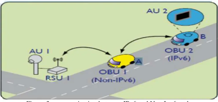
Infrastructure-less communications: Between vehicles alone without infrastructure support i.e. car to car communication. Infrastructure-based communications: Between vehicle and roadside peers or Internet peers.Two IPv6 Communication IPv6 and non IPv6 node Consider the scenario illustrate in figure3. Where two cars are driving around the roadside unit. Car A is within communication rage of RSU. Car B is out of the communication range of RSU but within the range of Car A. so the RSU reach to the CAR B via Car A. on the road IPv6 node (AUI) attached to the RSU 1 it’s functioning as an IPv6 Access Router (AR). In Car B IPv6 node (AU2) is attached to OBU functioning as an IPv6 mobile router its serving as in vehicle network in Car B. Car A not serve as a in vehicle network. So the AU1, AU2, RSU, OBU2 are IPV6 node. RSU, OBU1, OBU2 are equipped with wireless communication interface.
In the following figure3 AU1 is IPv6 camera AU2 is Laptop receiving and displaying the IPv6 video streaming from the camera
Figure 3: communication between IPv6 and Non Ipv6 node .
V. COMMUNICATION MODESS
The communication is done between the end points the end points are located in vehicle, roadside, or anywhere in the internet. Communication modes hold in the context of IPv6geonetworking: Vehicle-Vehicle (Communication occurs between a vehicle and another vehicle) Vehicle-Roadside (Communication occurs between a vehicle and the roadside) Vehicle-Internet (Communication occurs between a vehicle and a node located in the Internet).
a. Vehicle-based communication modes
This mode covers Vehicle-to-Vehicle communications without infrastructure support. Communication occurs between a vehicle and another or several vehicles. Applications based on IPv6 as well as other applications not based on IP can be supported, but only IPv6-based communications are in the scope of GeoNet. This mostly concerns safety and traffic efficiency applications.
b. Roadside-based communication modes This mode covers Vehicle-to-Roadside, Roadside-to-Vehicle and Vehicle-to-Vehicle communications with infrastructure support. Applications based on IPv6 as well as other applications not based on IP can be supported, but only IPv6-based communications are in the scope of GeoNet. This mostly concerns safety and traffic efficiency applications.
c. Internet-based communication modes
This mode covers Vehicle-Internet communications with infrastructure support. Note that any destination reachable through the Internet - including a destination vehicle – is considered as an Internet communication endpoint from the viewpoint of the source. Only applications based on IPv6 are supported. This mostly concerns infotainment, but numerous safety and traffic efficiency applications could benefit from this communication mode.
VI. COMMUNICATION FLOW
The destination range to consider from an IPv6 communication flow viewpoint is the following:
• IPv6 multicast: Communication between a single communication endpoint and multiple communication endpoints.
• IPv6 anycast: Communication between a single communication endpoint and a single arbitrary communication endpoint from a set of predefined devices.
The destination range to consider from a Geonetworking communication flow viewpoint is the following:
• GeoUnicast: Communication between a single communication endpoint and its identified counterparty located at a given geographical position.
Figure4: GeoUnicast
• GeoAnycast: Communication between a single communication endpoint and a single arbitrary communication endpoint from a set of predefined devices within a given geographical area.
Figure5: GeoAnycast
• GeoBroadcast: Communication between a single communication endpoint and all communication endpoints within a given geographical area.
Figure6: GeoBroadcast
IPv6 vehicle-based anycast (VA): Packets exchanged between two vehicles without infrastructure support. The end points are vehicle single vehicle endpoint identified by location (GeoAnycast). Event-driven low-latency query from a vehicle to an unknown neighbor vehicle heading in the opposite direction to report about traffic congestion. Example Traffic efficiency: Event-driven low-latency query from a vehicle to an unknown neighbor vehicle heading in the opposite direction to report about traffic congestion
IPv6 vehicle-based multicast (VM): Packets transmitted from a vehicle to multiple vehicles without infrastructure support the end points are vehicle. Multiple vehicle endpoints within a circle of specified radius around originator (GeoBroadcast).1 Road safety: Event-driven low-latency broadcast to multiple vehicles located within a geographical area in order to reliably and quickly disseminate safety information such as reporting
about black ice. 2. Road safety: Event-driven delay-tolerant IPv6 application-bound broadcast to multiple vehicles located within a geographical area piggy-backed over a sequence of beacons in order to reliably disseminate safety information by attaching it to scheduled network signaling. 3. IPv6 signaling: Periodic broadcast from a vehicle announcing the IP address range it can be reached at.
IPv6 roadside-based unicast (RU): Packets sent between the roadside and a vehicle at a specific location the end points are roadside originator and vehicle destination or vice-versa. Several of the communication endpoints and communication modes (e.g. Vehicle-Vehicle and Vehicle-Roadside).
IPv6 vehicle-based unicast (VU): Packets exchanged between two vehicles without infrastructure support. The end points are vehicles. Single vehicle endpoint of known identity whose position and identity are known through received beacons and/or a location service (GeoUnicast). Examples are: Road safety: Event-driven low-latency transmission from a vehicle announcing to a peer vehicle behind that it is decreasing speed. Infotainment: Delay-tolerant gaming between two vehicles with known identities. Single endpoint at specified geographic area or direction (GeoUnicast). Example: Road safety: event-driven low-latency packets sent from the roadside to a vehicle at a specific location and lane. Traffic efficiency: vehicle requesting to the roadside an empty space in parking lot.
IPv6 roadside-based anycast (RA): Packet sent from a roadside to a vehicle within the roadside's service area. The end points are roadside originator and vehicle destination. Single endpoint (GeoAnycast). Example: IPv6 signaling: IPv6 router advertisement and router solicitation sent between the vehicles and the roadside. Road safety: Dynamic speed limit notification from the roadside to all vehicles. Delivery of information to a vehicle at an unknown position (position request query flooding when the IPv6 access router has a message to deliver to a vehicle in its service area, but the vehicle's position is not known or delivery acknowledgement has timed out, a position request query may be flooded within its service area. The target vehicle responds with its current position. This procedure may be restricted to messages above a certain priority class).
IPv6 Internet-based unicast (IU): Bidirectional exchange between the vehicle and the Internet. Packets are first transmitted from the vehicle to the roadside and then from the roadside to the Internet, or vice versa. The end points are vehicle originator and Internet destination or vice versa. Single endpoints of known identity. Example: IPv6 signaling: IPv6 mobility management between vehicle and home agent. IPv6 application: traffic hazard (black ice, ghost driver) reported from the vehicle to some well-known server in the Internet.
GeoBroadcast). Example Road safety: Central server reporting about black ice to all vehicles in a geographic area
Three different end-to-end communication scenarios:
1. Information sent by a vehicle to all vehicles in an immediate geographic area around the vehicle (GeoBroadcast).
2. Information sent by a vehicle to a server in the Internet (IPv6 unicast / GeoUnicast).
3. Information sent by a server in the Internet to all vehicles in a given geographic area (IPv6 multicast / GeoBroadcast). Other end-to-end communication scenarios are not illustrated, 4.Information sent to any vehicle located in a target area (IPv6 anycast /GeoAnycast);
5. Information sent to one vehicle located in a given target area (IPv6 unicast /GeoUnicast).
In all of these scenarios, the sender and the receiver(s) could either be a vehicle, a roadside unit, or any node in the Internet, and the target area could be local (immediately surrounding the sender) or remote (reachable via other vehicles, roadside, or the Internet). Three types of hazard messages were reported: an accident, emergency vehicle, and congestion. The former two are directly reported by a moving vehicle (Green) to the road traffic centre while the latter is sent on demand by the traffic centre operator (in a real situation, the report would be sent based on fusion of information received at the traffic
VII. CONCLUSION
In this paper we study the main module architecture using IPv6 in vehicular ad-hoc network (VANET). Also show that communication between the end point using Geonetworking study all basic concepts related to the IPv6 using Geonetwork. The different way done the communication between the end points i.e. unicast multicast, Anycast, GeoBroadcast, GeoUnicast, GeoAnycast.
REFERENCES
[1] Yacine Khaled, Ines Ben Jemaa, Manabu Tsukada and Thierry Ernst “Application of IPv6 multicast to VANET” 2009 IEEE
[2] JinHyeock Choi, Yacine Khaled, Manabu Tsukada and Thierry Ernst ”IPv6 support for VANET with geographical routing” 2008 IEEE [3] B. Haberman and D. Thaler. Unicast-prefix-based ipv6 multicast
addresses. Rfc, IETF, 2002.
[4] Geonet project: http://www.geonet-project.eu.
[5] T. Hain. An ipv6 geographic global unicast address format. Internet-draft, IETF, 2008.
[6] Manabu Tsukada, Ines Ben Jemaa”experimental evaluation for IPv6 over VANET Geographic routing
[7] Satoru Noguchi, Manabu Tsukada”Real-vehical integration of driver support application with IPv6 GeoNetworking