USING THE GEOSPATIAL WEB TO DELIVER AND TEACH GISCIENCE EDUCATION
PROGRAMS
Bert Veenendaal
Department of Spatial Sciences, Curtin University, GPO Box U1987, Perth, Australia – [email protected]
Commission VI, WG VI/4
KEY WORDS: GIScience, GIS, Higher education, Geospatial web, Web mapping, Authentic learning
ABSTRACT:
Geographic information science (GIScience) education has undergone enormous changes over the past years. One major factor influencing this change is the role of the geospatial web in GIScience. In addition to the use of the web for enabling and enhancing GIScience education, it is also used as the infrastructure for communicating and collaborating among geospatial data and users. The web becomes both the means and the content for a geospatial education program. However, the web does not replace the traditional face-to-face environment, but rather is a means to enhance it, expand it and enable an authentic and real world learning environment. This paper outlines the use of the web in both the delivery and content of the GIScience program at Curtin University. The teaching of the geospatial web, web and cloud based mapping, and geospatial web services are key components of the program, and the use of the web and online learning are important to deliver this program. Some examples of authentic and real world learning environments are provided including joint learning activities with partner universities.
1. INTRODUCTION
Education programs and learning experiences in geographic information science (GIScience) have developed over the past couple of decades in response to changing technology as well as a changing learning and teaching environment. Not only the content of what is taught, but also the means of teaching it, have evolved dramatically.
One of the main influences in driving this change has been the advent and development of the web, and the geospatial web in particular (Unwin et al. 2012, Veenendaal 2000). The web has provided an underlying infrastructure and resource to share information, provide online learning resources, and enhance the communication and interaction among learners and with teachers. Learning management systems designed around an online environment support both face-to-face and distance education.
At the same time, the development of the geospatial web has triggered the expansion of GIScience programs to include a range of content and skills in relation to web mapping, online geospatial web services, virtual globes, web geographic information systems (GIS), mobile mapping, etc..
Additionally, the web has brought together a global village where people from all over the world are connected to this infrastructure and have access to information and interaction irrespective of time and place. This has opened up the possibilities for learning to a greater number and diversity of students worldwide. This has especially fostered the growth of distance and blended learning opportunities that have expanded over the past decade (Foote et al. 2012).
This paper explores role of the web and its influence on the changing face of GIScience higher education. Although many of the main changes and influences are identified, the list is not exhaustive.
2. BACKGROUND AND DEVELOPMENTS
2.1 Development of GIScience education
GIScience and GIS higher education have rapidly developed over the past three decades alongside the developments in GIS and geospatial technologies (Figure 1) (Unwin et al. 2012, Veenendaal 2014). Specific programs, mostly at a postgraduate level, were developed in the 1980s to focus primarily on training in the use of GIS software (Foote et al. 2012). The first undergraduate GIS (then using the term GI “systems”, now “science) bachelor degree was developed by Curtin University in 1992 (Veenendaal 2014) and that decade ushered in many more programs taught primarily by geography and surveying departments at higher educational institutions worldwide. The NCGIA core curriculum was released in 1990 to support the emerging GISc programs and assist educators with teaching resources (Goodchild and Kemp 1990, 1992).
This first era of the 1990s also saw the advent and growth of the internet and web. It was initially primarily a data repository with the ability for many geographically disparate users to access and share data and information. With the ability to hyperlink to additional information came also the ability to display and link to maps and basic mapping data and hence, the first web maps were developed (Peterson 2014) commencing with the Xerox PARC Map Viewer in June 1993 (Xerox 2015).
The decade of the 2000s witnessed an expansion of GISc programs worldwide with initiatives to define and consolidate the knowledge and skills content of the GIScience domain. Some of these initiatives include the revised NCGIA Core Curriculum (NCGIA 2000), the Geographic Information Science and Technology (GIS&T) Body of Knowledge (Dibiase et al. 2006), the Geospatial Technology Competencies Model (GTCM) (DOLETA 2010), and the Encylopedia of Geographic Information Science (Kemp 2008). Hence there was a shift from a “systems” focus to a “science” focus.
Additionally, this decade has ushered in digital virtual globes including Google Earth, NASA World Wind and Microsoft Bing Maps which exposed maps and GIS to a much wider audience via the web (Foote et al. 2012). Improved web technologies paved the way for more interactive online maps and the ability to create map mashups from multiple online data sources. These online mapping resources became utilised within GISc programs and at the same time used as a means to reach the wider diversity of students being exposed to geospatial technologies and GIS. In other words, virtual globes were used as a means to teach mapping and geographic information to learners from disciplines that were not directly linked to GIS nor needed to understand the complexities of GIS technology in order to benefit from maps and mapping.
For the current decade, GIScience education has focussed on integration and collaboration among the many resources and users accessible on the web. Web and cloud based GIS and mapping systems are addressing many varied applications that integrate data and information from a wide variety of online sources and provide mapping and geospatial services to a wide range of diverse users. In addition, mobile devices and location based services are adding to the exposure by the global community to maps, location and information about the geographic vicinity in which one is located or moving about.
GIScience programs have had to address these challenges and expand to include web and cloud based mapping and services, geospatial workflows, inter-organisational collaboration, community participation and a wider range of applications that have now been exposed to geospatial information online. Different educational offerings have developed to address different target audiences in different contexts using different designs and teaching modes with different learning outcomes (Prager 2012, Veenendaal 2014).
2.2 Development of the web in GIScience education
The web has played a crucial role in the development of higher education including that for GIScience. In the first era of the 1990s, the web became used as a repository for information accessible online anywhere and anytime. This was particularly useful for distance based learning programs where paper and postal services began to be replaced by online web sites and documents. This is how the UNIGIS program evolved in the 1990s. The UNIGIS program was one of the earliest distance
learning initiatives in the GISciences, originating in the early 1990s from universities in the UK, Netherlands and Austria (Strobl 2012).
Learning management systems and content management platforms eventually provided more sophisticated resources for a learning environment. These resources expanded to include a range of communications facilities, content organisation, assessment resources, tools and monitoring, student group management, multi-media tool offerings, etc. These platforms and resources provided the basis for expanding distance-based geospatial education offerings. Most notable of these are the UNIGIS network (since 1990), Penn State World Campus, the GITTA joint project in Switzerland (since 2001), the Lund University Master’s degree in Sweden (since 1999), and the Curtin University distance GIScience offerings (since 1998) (Dibiase 2012, Veenendaal 2000).
In addition to supporting distance education offerings, web-based learning resources also came to be utilised for on-campus and face-to-face learners. Given the benefits of the web in terms of access to information any time and any place, it was a logical progression to provide the online learning information and resources to students to access when off-campus or when absent from learning events.
3. EDUCATION FRAMEWORK FOR A GISCIENCE PROGRAM
3.1 GIScience education framework components
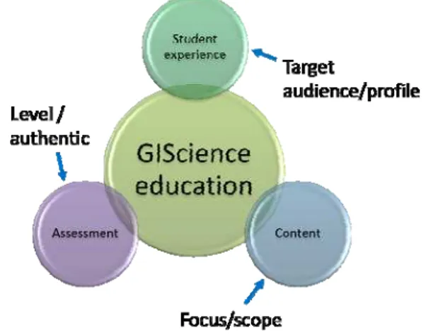
Building a successful GIScience education program is a daunting task, given the complexity and components that need to be addressed. The important components – content, assessment and student experience – must be well focussed, well integrated and well supported (Figure 2). Although these components have always been part of GIScience education programs, the relative efforts and complexity have changed over the three decades of development.
Figure 2: Mandatory components of a GIScience education program
The majority of time and effort has traditionally gone into the content component, identifying the focus for topics and building the content elements. Hence the first two eras of GIScience education saw much effort go into building the curricula content comprising topics and modules of knowledge and skills. The notable deliverables of those efforts are the The International Archives of the Photogrammetry, Remote Sensing and Spatial Information Sciences, XL-6/W1, 2015
NCGIA Core Curriculum and the GIS&T Body of Knowledge. Ironically, most web and cloud based mapping and GIS topics and skills are not adequately covered by these curricula, as the pace of technology has moved quickly beyond the time of their release. There have been no updates to keep up with the fast rates of changing technologies.
On the other hand, moving into the third era, the GTCM focusses more on the framework and organisation for a curriculum in relation to stakeholders and types of competencies. Such an approach fosters flexibility in educational offerings so that different disciplines and target audiences can be catered for. The web has provided the platform to provide the content, but more importantly to manipulate it to cater for the different offerings and users.
The assessment component needs to measure the students’ abilities to grasp the learning outcomes identified in the content module. Assessments need to be designed at a level appropriate to the background and focus of the learners and their learning outcomes. They also need to be authentic and relevant to real world experiences, applications and examples. There are very few assessment resources available in the public domain. The national/international GIScience curriculum efforts do not detail the design and content of assessments. Most assessments are developed at an individual institutional or instructor level. This is also what particularly distinguishes educational offerings from each other.
The student experience component is an interplay of how content and assessment is delivered and experienced at a practical level. It is the outcome of how content and assessment are integrated in relation to the background, expectations and goals of a learner. This necessitates the design and delivery of different programs that cater to different student groups with varying backgrounds upon entry and with different goals upon graduation.
The following sections outline more of the factors that influence the design and delivery of each of the three components. The web is an integral part of the development of these components and has strongly influenced where GIScience education is at today. The elements of and experiences with the GIScience programs at Curtin University are especially used in the following discussion.
3.2 GIScience content component
Of course the content of GIScience educational offerings has had to expand to include new knowledge and skills including web mapping and online GIS technologies. GIScience programs now include exposure to online mapping applications including digital virtual globes, online geospatial data and resources, mobile mapping and web GIS. Many GIScience programs will additionally include curriculum content on geospatial web services, web mapping application programming interfaces (APIs), building web map mashups, cloud computing, web map programming, mobile map apps and establishing web map services.
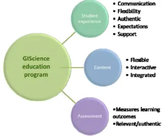
As already indicated, the primary focus in more recent years has shifted away from building content itself to creating a more flexible, interactive and integrated environment (Figure 3) to be able to customise content and cater for different learner needs. Hence, different educational institutions will build different offerings at the undergraduate or postgraduate levels, taking
into account previous education and workplace experience of students. They also may focus on particular topics or strengths within the GIScience discipline based on their staff profiles or strategic directions to differentiate from other educational offerings and institutions.
Figure 3: Education framework for a GIScience program
Another distinguishing feature is the mode of delivery of content. In the early eras of GIScience education, programs were offered as either face-to-face or distance based, or both. In fact, the content was often packaged differently to cater for the different modes of learning. For example, the GITTA project developed online pools of lessons and learning materials which could then be organised into different courses for e-learning (Weibel et al. 2012). In the early development of the GIScience distance programs at Curtin University, the content was assembled into online modules for distance students to work through them independently.
However, the sharp distinction between face-to-face students and distance students as eroded over time. The reason is that there is a greater demand for flexibility and blended learning where face-to-face students are not present at all face-to-face learning events, and distance students may come on campus from time to time, or desire more of the “classroom experience”.
At Curtin University, this challenge has been met with video-recorded face ilectures made available for all face-to-face as well as distance students. In fact, this is now being enhanced with live ilectures where distance students can use online resources to “virtually join” the lecture by watching it live on video and asking questions directly to the lecturer via chat tools. In this way, the same content can be delivered to both face-to-face and distance students simultaneously, or asynchronously if students are not able to join because of different time zones or other reasons. These ilectures have subsequently replaced the online content modules and hence abolished the need to maintain and update separate online content for distance students.
3.3 GIScience assessment component
the focus being on the technology and operation of GIS systems in the early years of GIS education, the assessments were designed with this in mind. However, the need to cater for different student cohorts and in different contexts means that assessments may vary quite markedly across different programs and even for different students within the same program. They must directly address the learning outcomes which may vary among different GIScience programs and for different student cohorts.
At Curtin University, most GIScience assessments are conducted, made available and/or submitted online using web learning management tools. In addition to providing access for on-campus and distance learners, the online tools also provide for flexibility in re-mixing and re-using assessments for the different learner cohorts. For example, undergraduate and postgraduate students may share many of the same online learning resources, but their assessments may vary according to different learning outcomes or taking into account the different backgrounds of high school leavers versus those that have previous degree qualifications.
Assessments must also be relevant to real-world experiences and expectations of industry (Figure 3). This has received increasing attention over more recent educational eras with a greater focus on such concepts as field work, authentic learning, work integrated learning (WIL), personalised learning and adaptive learning.
The GIScience undergraduate Bachelor program at Curtin University includes a WIL unit in which students perform a work placement and are assessed using both academic and industry supervisor measures. Students are exposed to, for example, organisational structures, processes, workflows, procedures, standards and interactions. The web can be used to enhance these activities; an example is provided in Section 3.4 in relation to authentic learning.
3.4 GIScience student experience component
The student experience is arguably the most important component of an education program. Traditionally it has had the least focus of the three components. This is for various reasons, but could also include the fact that when the GIScience programs were initially established, there was a lack of content and assessment resources and hence most of the efforts were put into designing and building them. With the increasing proliferation of GIScience course offerings and the increasing competition for students, the learning experience is an important factor in attracting and retaining students.
As listed in Figure 3, the student experience component involves a number of factors including communication, flexibility, expectations and support. The modes of communication have expanded beyond email and online discussion forums to include social networking and mobile apps. Most learning management systems now have apps that provide a range of functionality on mobile phones to facilitate communication with instructors and among students, as well as providing information such as assessments, grades, etc. Curtin University students have the option to download the
Blackboard Mobile Learn app which provides them with access
to course and communications tools and information at any time and place from their mobile phones.
Students increasingly want flexibility in the way they learn and hence the shift towards blended learning. They want to be able to access different modes of learning depending on what suits their schedule or current commitments. This demand for flexibility is greater for more mature students, presumably because of their increased commitments to work, family, travel and other. At Curtin University, both undergraduate and postgraduate students in GIScience have the option to undertake their GIS units in face-to-face mode, fully distance mode or blended learning mode in which they arrange or vary the extent of face-to-face learning activities versus distance learning activities to suit their commitments and movements.
Authentic learning provides students with real world experiences and skills involving real life and workplace processes. This goes beyond the traditional content delivery and regurgitation learning models. A weakness of the web is that it can simply be used as a content resource where students need to discover and regurgitate information. However, because the web is also being increasingly used as an infrastructure for workflows and processes, it can usefully be used within the context of authentic learning activities.
To enhance authentic learning at Curtin University, students are assigned to teams that outline, analyse, solve and evaluate a problem for a real industry organisation whose representatives function as a “problem owner”. The students then work through the entire workflow from problem identification to problem solution and evaluation with real world industry representatives assessing their progress and performance. Web-based learning resources are used to share and document the solutions and experiences of collaborating students. In fact, in a Web
Mapping subject, students were selected to participate in a
collaborative effort with students from a partner university in an overseas country to work on developing a web mapping solution for a major government organization. This is a perfect example of using the web resources to develop a web map in an authentic learning environment with the outcome being a real geospatial product useful to an organisation. In the process, students were exposed to working with others in a different culture and organisation, and utilising their organisational workflows and processes to accomplish the (learning) tasks.
An important aspect of enhancing a student experience is to set and meet student expectations. Students have different expectations depending on such aspects as: their purpose for study, their mode of study (eg. on-campus, distance), cost of enrolment, balancing their life commitments (eg. family, work, study, health, leisure), past study experiences, and culture/backgrounds. Hence it is very likely that within a particular cohort of students, and indeed in the same subject, many different expectations exist. In fact, the increasing use of mobile communication and social networking – the need to be “connected” – especially among younger learners, creates its own set of expectations by students. The web, being a fundamental component of modern communication technologies, must be well integrated into teaching/learning programs to continue to meet learner expectations. For Curtin University GIScience students, this involves regular communication by instructors on at least a weekly basis to all students using the modern communication tools as a means to set, explain and satisfy expectations. In other words, meet expectations by setting expectations using regular contact as per expectations!
Students also expect a high level of support as needed and on demand. The “find it” tendency by searching online to find answers to questions as they arise also finds its way into education programs. When students have queries about concepts, need GIS software assistance, are developing problem-solving skills, are debugging customised web map scripts, etc., they would like to access support with quick response times. The easy access to the web, mobile communications and social networking is feeding and raising such high expectations. It is necessary to have a support system in place for students, but also to identify the expectations for responses and response times which are realistic and reasonable.
4. SUMMARY AND CONCLUSIONS
This paper outlines the changing nature of GIScience education over the past three decades and the role of the web in fostering and enhancing that change. Three components of the learning environment – content, assessments and student experience – were identified and the developments over the history of GIScience education are outlined.
Whereas the original focus in the early years of GIScience education were on content, the more recent focus is on student experiences. The web has both facilitated and created opportunities for increased flexibility in the way students learn. Rather than a sharp distinction between face-to-face and distance modes of learning, blended learning provides a combination of both where web learning resources support learning activities. Hence the delivery of content and the setting of assessments need not be distinguished by the mode of learning. Rather, they are adapted and customised to diverse needs and expectations of different cohorts of students.
The result is that there needs to be a better integration and remixing of a range of learning resources and experiences in relation to varying learning outcomes, authentic learning experiences, assessments, etc. that cater for the different requirements of students. In fact, the growth of web and cloud mapping and services technologies has given cause to extend the GIScience curriculum as geospatial applications embrace these expanding developments. Hence the great value for GIScience education to teach and use the same infrastructure.
The web has become a crucial infrastructure to enable these GIScience learning environments and meet student expectations. Students want their learning integrated with the rest of their lifestyle activities, and the web is simply becoming a more seamless but fundamental infrastructure of enablement. The challenge for educators will be to identify and meet the changing requirements and expectations of learners by further enhancing a seamless and integrated learning environment that provides an excellent student learning experience. So what are the next web developments that will underpin this infrastructure?
REFERENCES
DiBiase, David. 2012. GIS&T in the open educational resources movement. In Unwin et al. (2012).
DiBiase, David, Michael DeMers, Ann Johnson, Karen Kemp & Ann Taylor Luck (editors). 2006. Geographic Information
Science and Technology Body of Knowledge. Association of
American Geographers, Washington, USA.
DOLETA. 2010. Geospatial Technology Competency Model. Employment and Training Administration, United States Department of Labour, updated by GeoTech Center, http://www.careeronestop.org/competencymodel/competency-models/geospatial-technology.aspx (13 May 2015).
Foote, Kenneth E., David J. Unwin, Nicholas J. Tate and David DiBiase. 2012. GIS&T in higher education: challenges for educators, opportunities for education. In Unwin et al. (2012).
Goodchild, M.F., and K.K. Kemp, eds. 1990. NCGIA Core Curriculum in GIS. National Center for Geographic Information Analysis, University of California, Santa Barbara CA, http://www.geog.ubc.ca/courses/klink/gis.notes/ncgia/toc.html (11 May 2015).
Goodchild, M.F. and K.K. Kemp. 1992. NCGIA education activities: The core curriculum and beyond. International Journal of Geographical Information Systems, 6(4): 309-320.
Kemp, K. K. (Ed.). 2008. Encyclopedia of geographic information science. Thousand Oaks, CA: SAGE Publications, Inc. doi: http://dx.doi.org/10.4135/9781412953962.
Li, S, B Veenendaal & S Dragićević. 2011. Advances, and future directions in web-based GIS mapping services. In Li, S, Dragićević, S and Veenendaal B (2011) Advances in Web-based GIS, Mapping Services and Applications, Taylor & Francis Group, London, ISBN 978-0-415-80483-7.
NCGIA. 2000. The NCGIA Core Curriculum in GIScience. National Center for Geographic Information Analysis, University of California, Santa Barbara CA, http://www.ncgia.ucsb.edu/giscc/aboutgiscc.html (15 Jan 2014).
Peterson, Michael P. 2014. Mapping in the cloud, The Guilford Press, New York, ISBN: 978-1-4625-1041-2.
Strobl, Josef. 2012. UNIGIS – networked learning over a distance. In Unwin et al. (2012).
Unwin, David J., Kenneth E. Foote, Nicholas J. Tate and David DiBiase. 2012. Teaching Geographic Information Science and Technology in Higher Education. Wiley-Blackwell, John Wiley & Sons, Ltd, Chichester, UK, ISBN: 978-0-470-74856-5.
Veenendaal, B. 2000. Flexible and web-based delivery of GIScience in higher education. Proceedings of the International IT Conference on Geo-Spatial Education, Hong Kong, 6-8 July, ISBN 962 367 281 0, pp 181-194.
Veenendaal, B. 2014. Development of a flexible higher education curriculum framework for geographic information science. ISPRS Ann. Photogramm. Remote Sens. Spatial Inf. Sci., II-4, 77-82, doi:10.5194/isprsannals-II-4-77-2014.
Weibel, Robert, Patrick Luscher, Monika Niederhuber, Thomas Grossmann and Susanne Bleisch. 2012. Delivering GIScience education via blended learning: the GITTA experience. In Unwin et al. (2012).
Xerox. 2015. Xerox PARC Map Viewer. Palo Alto Research Center, http://www.inwap.com/inwap/chez/parc-map.html (12 May 2015).
ACKNOWLEDGEMENTS
I would like to acknowledge my colleagues and the many students at Curtin University who have provided their insight and feedback to enable me to gain and share the experiences of developing and enhancing the GIScience program. We will continue to strive to promote excellent student learning experiences.