SED
7, 1731–1759, 2015Socio-economic modifications of the
Universal Soil Loss Equation
A. Erol et al.
Title Page
Abstract Introduction
Conclusions References
Tables Figures
◭ ◮
◭ ◮
Back Close
Full Screen / Esc
Printer-friendly Version Interactive Discussion
Discussion
P
a
per
|
Discussion
P
a
per
|
Discussion
P
a
per
|
Discussion
P
a
per
|
Solid Earth Discuss., 7, 1731–1759, 2015 www.solid-earth-discuss.net/7/1731/2015/ doi:10.5194/sed-7-1731-2015
© Author(s) 2015. CC Attribution 3.0 License.
This discussion paper is/has been under review for the journal Solid Earth (SE). Please refer to the corresponding final paper in SE if available.
Socio-economic modifications of the
Universal Soil Loss Equation
A. Erol1, Ö. Koşkan2, and M. A. Başaran3
1
SDÜ Faculty of Forestry, Department of Watershed Management, Isparta, Turkey
2
SDÜ Agricultural Faculty, Department of Biometric Genetics, Isparta, Turkey
3
Western Mediterranean Forestry Research Institute, Antalya, Turkey
Received: 28 April 2015 – Accepted: 1 May 2015 – Published: 15 June 2015
Correspondence to: A. Erol ([email protected])
SED
7, 1731–1759, 2015Socio-economic modifications of the
Universal Soil Loss Equation
A. Erol et al.
Title Page
Abstract Introduction
Conclusions References
Tables Figures
◭ ◮
◭ ◮
Back Close
Full Screen / Esc
Printer-friendly Version Interactive Discussion
Discussion
P
a
per
|
Discussion
P
a
per
|
Discussion
P
a
per
|
Discussion
P
a
per
|
Abstract
While social scientists have long focused on socio-economic and demographic fac-tors, physical modelers typically study soil loss using physical factors. In the current environment, it is becoming increasingly important to consider both approaches si-multaneously for the conservation of soil and water, and the improvement of land use
5
conditions. This study uses physical and socio-economic factors to find a coefficient
that evaluates the combination of these factors. It aims to determine the effect of
socio-economic factors on soil loss and, in turn, to modify the Universal Soil Loss Equation (USLE). The methodology employed in this study specifies that soil loss can be cal-culated and predicted by comparing the degree of soil loss in watersheds, with and
10
without human influence, given the same overall conditions. A coefficient for
socio-economic factors, therefore, has been determined based on adjoining watersheds (WS I and II), employing simulation methods. Combinations of C and P factors were used in the USLE to find the impact of their contributions on soil loss. The results revealed that these combinations provided good estimation of soil loss amounts for the second
15
watershed, i.e. WS II, from the adjoining watersheds studied in this work. This study
shows that a coefficient of 0.008 modified the USLE to reflect the socio-economic
fac-tors as settlement influencing the amount of soil loss in the watersheds studied.
1 Introduction
Soil erosion is a natural process for landscape development if accelerated denudation
20
processes by human impact. Moreover, it determines the landscape and the landforms, the soil and water quality, the vegetation recovery and the fate of the societies (Zhao et al., 2013). This phenomenon is a globally environmental threat that reduces the productivity of all natural ecosystems (Kertész, 2009; Pimentel and Burgess, 2013; Leh et al., 2013) including soil where the adaptation capacity is weak (Cerdà, 2000;
25
SED
7, 1731–1759, 2015Socio-economic modifications of the
Universal Soil Loss Equation
A. Erol et al.
Title Page
Abstract Introduction
Conclusions References
Tables Figures
◭ ◮
◭ ◮
Back Close
Full Screen / Esc
Printer-friendly Version Interactive Discussion
Discussion
P
a
per
|
Discussion
P
a
per
|
Discussion
P
a
per
|
Discussion
P
a
per
|
the world’s arable land is significantly degraded by soil erosion. Additionally, erosion-induced soil quality deterioration is prevalent all over the world (Harden, 2001; Zhao et al., 2013) obstructing the global food source and socio-economic security. Young (1993) indicated that the challenges of soil erosion are more severe in the heavily populated, under-developed, and ecologically fragile areas of the world. Lal (1981) and
5
Eswaran et al. (2001) asserted that misuse of soils, resulting from a desperate attempt by farmers to increase production for the growing population aggravates soil quality degradation. Tesfahunegn (2013) further claims that severity of such degradation is higher in developing countries where the economy mainly depends on agriculture.
Soil erosion, which is one of the primary issues that forestry and agriculture
agen-10
cies have to deal with, is a critical problem in Turkey. The current population of Turkey
is 76.7 million (TUİK, 2014), and the land surface area is 78 million ha; this comprises
36 % of agricultural land, 27.6 % of rangeland, and 29.8 % of forest and shrub cover,
with the remaining 6.5 % of land accounting for settlements and water bodies (OSİB,
2005). To put it bluntly, it is anticipated that there will be a dramatic increase in
set-15
tlements due to rapid population growth which results in intensive construction in the mountainous areas of which especially used agriculture and forest. Indeed, soil erosion is a key issue in mountainous regions worldwide (Leh et al., 2013; Mandal and Sharda, 2013; Haregeweyn et al., 2013; Wang and Shao, 2013). Mountain soils develop in very sensitive environments subject to natural and anthropic disturbances (e.g. Cerdà and
20
Lasanta, 2005; Vanwalleghem et al., 2011; Van der Waal et al., 2012; García Orenes et al., 2012), and they are often located at the interface with densely settled areas,
which may be considerably affected by sediment release from upstream erosion
(Zia-dat and Taimeh, 2013; Cao et al., 2014; Lieskovsk´y and Kenderessy, 2014). Similarly, watersheds of Turkey are located at mountainous areas and these areas mainly under
25
the effect of soil erosion impact water quality and quantity. Thus, their soils are very
SED
7, 1731–1759, 2015Socio-economic modifications of the
Universal Soil Loss Equation
A. Erol et al.
Title Page
Abstract Introduction
Conclusions References
Tables Figures
◭ ◮
◭ ◮
Back Close
Full Screen / Esc
Printer-friendly Version Interactive Discussion
Discussion
P
a
per
|
Discussion
P
a
per
|
Discussion
P
a
per
|
Discussion
P
a
per
|
considerable spatial heterogeneity in terms of land use and management, topography, and socio-economic conditions all over Turkey.
Foley et al. (2011) made a global emphasis on the soil erosion problem that the global population is predicted to reach 9 billion by 2050; in combination with changes in dietary behavior, a large net increase in productivity and/or agricultural area is needed.
5
Additionally, Brevik et al. (2015) argued that soils are thus under increasing environ-mental pressure, and this will have consequences for the capacity of the soil to continue to perform its variety of functions. Environmental degradation from human pressures and land use has become a major worldwide problem (Wilson, 1992), however, the
effects are felt more in developing countries due to the high population growth rate and
10
the associated rapid depletion of natural resources (Feoli et al., 2002). According to Udo et al. (1990) soils are impoverished and may have also been destroyed by ero-sion in very densely populated areas. Similarly, on the national level, soil eroero-sion is expected to increase (Nearing et al., 2004; IPCC, 2007). Thus, amelioration measures should be taken in all countries especially at the regional and national level.
15
However, some studies declared the extent, severity, and consequences of soil degradation remain poorly documented (Bai et al., 2008; Wessels, 2009), there is a vital need for quantitative, repeatable measures of degradation (Brevik et al., 2015) and/or soil loss. Since biodiversity loss, soil degradation or soil loss and changing in climate are now gradually related to food security, water security, energy security, biodiversity,
20
and many ecosystem services such as food, water and energy security, biodiversity, this critical phenomenon is an international problem. The high rate of erosion under human influences therefore has necessitated the determination of soil loss caused by socio-economic factors and other environmental drivers in order to identify and imple-ment sustainable manageimple-ment practices.
25
SED
7, 1731–1759, 2015Socio-economic modifications of the
Universal Soil Loss Equation
A. Erol et al.
Title Page
Abstract Introduction
Conclusions References
Tables Figures
◭ ◮
◭ ◮
Back Close
Full Screen / Esc
Printer-friendly Version Interactive Discussion
Discussion
P
a
per
|
Discussion
P
a
per
|
Discussion
P
a
per
|
Discussion
P
a
per
|
context, the most efficient approach for minimizing erosion problem is thought to be the
use of resources in a timely and organized manner. Haregeweyn et al. (2013) stated that critical erosion hotspots are defined as parts of watersheds with high erosion rates. These hydrological units are also under the influence of human activity including socio-economic factors causes changing the character of the watershed. On the other hand,
5
determining the influential socio-economic “causes” of erosion is just as complex. Fur-thermore, data to be determined causes of erosion is very scarcely limited. According to MacGillivray (2007), many of the political and socio-economic factors, however, are
regionally effective and intangible. On the other hand, it is important to assess the
degree of soil erosion under different environmental and socio-economic situations in
10
order to identify and apply suitable land management interventions (Castro et al., 2001)
understand the causes and effects of soil erosion. Therefore, there is a need for more
research on the relationship between cause and effect of erosion. Haregeweyn et al.
(2013), however, signified that spatial data to determine soil erosion in the developing countries is often scarce and possibilities to identify source areas for erosion and
sed-15
iment are very limited. As a matter of fact, Turkey also should be considered to be one of them.
Land degradation and in particular, soil erosion, has long been studied as a phys-ical process by scientists using USLE from backgrounds as a diverse as geography, geology, agronomy, and engineering (Boardman et al., 2013). USLE proceeds to be
20
the most widely used model for soil loss estimations. Several studies have been per-formed in India (Ali and Sharda, 2005; Sharda and Ali, 2008; Narain et al., 1994) and other countries (Van Rompaey et al., 2002; Larsonm et al.,1997) to estimate the
per-formance of the USLE in predicting soil loss under different situations (Mandal and
Sharda, 2013). Besides, in eastern Himalayan regionpotential soil erosion rates for
dif-25
ferent states of the region were estimated by collecting data on various parameters of USLE by Mandal and Sharda, 2013.
However, the USLE is often criticized for its limited applications (Castro et al., 2001),
SED
7, 1731–1759, 2015Socio-economic modifications of the
Universal Soil Loss Equation
A. Erol et al.
Title Page
Abstract Introduction
Conclusions References
Tables Figures
◭ ◮
◭ ◮
Back Close
Full Screen / Esc
Printer-friendly Version Interactive Discussion
Discussion
P
a
per
|
Discussion
P
a
per
|
Discussion
P
a
per
|
Discussion
P
a
per
|
loss. Jayarathne et al. (2010) established that there is a strong positive relationship between land degradation and soil erosion, as well as land degradation and population density. Strong negative relationships were also observed between land degradation and land/man ratio. Boardman et al. (2003) stated the physical and socio-economic factors drive soil erosion; therefore, these factors need to be addressed in tandem.
5
However, it is often the case that the studies on this subject are not given in an interdis-ciplinary fashion (Boardman et al., 2003). Given this view, evaluating physical factors with socio-economic factors is the best starting point for determining the degree of soil
loss using two different disciplines. Additionally, Evans (1996) made an attempt with his
assessment of the socio-economic and physical drivers, impacts and costs of erosion
10
for UK and Wales. On the other hand, few studies have evaluated both physical and
socio-economic factors, using the effects of settlements in the USLE method. However,
Veldkamp and Lambin (2001) states that the incorporation of socio-economic drivers of land use change is critical for the accurate representation of land use change. Be-sides, as pointed out by Verburg et al. (2004), the integration of social, political, policy
15
and economic factors into land use change modeling are often not successful because
of difficulties in quantifying socio-economic factors and integrating such data with other
environmental data (Leh et al., 2011).
In the present study, socio-economic factors were spatially considered as settle-ments including humans and animal shelters. Thus, cropping management (C
fac-20
tor) and erosion control practice (P factor) were used to estimate the contribution of socio-economic factors in the USLE (Wischmeier and Smith, 1962, 1965, 1978; Lal,
1994). In addition, a calculation method was suggested to determine a coefficient that
would consider the interactions of physical and socio-economic factors using a simu-lation method. The amount of soil loss resulting from human and animal influence in
25
settlements was calculated using simple mathematical equations. Using this method,
a coefficient that could distinguish between settlements, which consists of both humans
and animals, and physical factors affecting erosion, was incorporated into the USLE for
SED
7, 1731–1759, 2015Socio-economic modifications of the
Universal Soil Loss Equation
A. Erol et al.
Title Page
Abstract Introduction
Conclusions References
Tables Figures
◭ ◮
◭ ◮
Back Close
Full Screen / Esc
Printer-friendly Version Interactive Discussion
Discussion
P
a
per
|
Discussion
P
a
per
|
Discussion
P
a
per
|
Discussion
P
a
per
|
In this study, we hypothesized the presence of settlements in the study area, where the impact on erosion in the USLE depended on the number of people and animals. The objective is to determine if any of these factors contribute to erosion, and how much the factors would influence the outcome of the USLE.
2 Materials and methods 5
2.1 Description of the study area
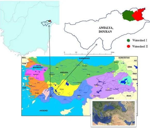
Two small adjoining watersheds (36◦54.074′N; 30◦31.536′E) covering areas of 700
and 800 ha, respectively, located in a small Mediterranean Watershed in Antalya, west-ern Turkey (Fig. 1), were selected as the study areas. Thus, these watersheds with similar properties allow comparison with each other (Özhan, 2004). Hereafter, the
wa-10
tersheds were referred to as WS I and II; some of their features are described in Table 1. Of the total area of WS I (i.e., 700 ha), 98.63 % is covered with dense forests, open forests, and lakes, but 68 % of the total area of dense forest and open forest included forest trees and other vegetation types. Additionally, open forest was a forest area not characterized by productive forest cover, due to destruction. Therefore, these forest
15
areas were labeled as dense and open forests in the two adjoining watersheds. Land uses in WS I covered dense forest, open forest, and lakes, constituting 630.4, 60.4, and 9.2 ha, respectively. The land uses in WS II were dense forest, open forest, lake, orchard, agricultural land, settlement, and greenhouse, which accounted for 408, 8, 2, 255, 68, 11, and 48 ha, respectively, of the total area of the watershed (800 ha). Of the
20
total area, 92.35 % of WS II was covered with dense forest, open forest, lake, orchard, agriculture, settlement, greenhouse and 40 % of these areas were covered with various types of vegetation (Table 1).
All data for this study, such as topographic features, were obtained from GIS; the
effects of the physical and socio-economic factors used to determine the USLE
SED
7, 1731–1759, 2015Socio-economic modifications of the
Universal Soil Loss Equation
A. Erol et al.
Title Page
Abstract Introduction
Conclusions References
Tables Figures
◭ ◮
◭ ◮
Back Close
Full Screen / Esc
Printer-friendly Version Interactive Discussion
Discussion
P
a
per
|
Discussion
P
a
per
|
Discussion
P
a
per
|
Discussion
P
a
per
|
efficient were obtained from the past references (Doğan and Güçer, 1976; Arnoldus,
1977; Balcı, 1996; Cebel et al., 2013).
2.2 Data from GIS and past references
The topographic features and land use data of the two adjoining watersheds were obtained using GIS methods and the topographic data of the watersheds (Tables 1–3).
5
Slope length (l) and slope steepness (s) factors, used to calculate L and S in the USLE, were also obtained using GIS (Table 2 and 3). Soil erodibility (K factor), rainfall (R factor) (Table 2 and 3), cropping management (C factor), and erosion control practices
(P factor) (Tables 4 and 5) were provided from data of the past references (Doğan
and Güçer, 1976; Arnoldus, 1977; Balcı, 1996; Cebel et al., 2013). In the study, WS I
10
was found to have experienced almost no human impact, whereas WS II suffered from
intensive human impact. K factor of 0.12 was used owing to the surface depth of the soil and represented Red Mediterranean Soils (Cebel et al., 2013) both in WS I and II. R factor (415.2) was used owing to the presence of Red Mediterranean Soils and
the moderately erodible soils for both WS I and II (Doğan and Güçer, 1976) (Tables 2
15
and 3). Data relating to L and S of l and s (Tables 2 and 3) used in the USLE were
determined using equations from past references (Eqs. 1 and 2) (Balcı, 1976).
2.3 Data obtained for the USLE
The USLE is used in Turkey as the most common mathematical model for predicting the amounts of soil loss in forests and rangelands. Previously, Turkey has been studied
20
primarily with reference to the R, C, and P factors in the model (Doğan and Güçer,
1976; Çanga, 2006). The C and P factors for the watersheds were adapted from past
references (Balcı, 1996), and many other previous studies were investigated in terms of
the various USLE factors. The values for the C and P factors reported by Balcı(1996)
were determined for a study area with properties identical to those of the existing study
25
SED
7, 1731–1759, 2015Socio-economic modifications of the
Universal Soil Loss Equation
A. Erol et al.
Title Page
Abstract Introduction
Conclusions References
Tables Figures
◭ ◮
◭ ◮
Back Close
Full Screen / Esc
Printer-friendly Version Interactive Discussion
Discussion
P
a
per
|
Discussion
P
a
per
|
Discussion
P
a
per
|
Discussion
P
a
per
|
this study (Tables 4 and 5). The USLE can be presented as follows:
A=KRLSCP, (1)
where (A) is the annual soil loss (t ha−1year−1). In Eq. (1), the impacts of slope length and steepness were usually combined into one single factor (Randle et al., 2003),
known as the topographic factor (LS) (Balcı, 1996), which can be computed as follows:
5
LS=l0.5(0.0136+0.00965s+0.00138s2) (2)
sand l calculated to the LS factor for the studied watersheds were 1.32 for WS I and
0.714 for WS II (Tables 6 and 7). As can be seen in these tables, the K, R, C, and P fac-tors established for the USLE for dense forests, open forests, orchards, and agricultural
lands in both watersheds were obtained from the past references (Doğan and Güçer,
10
1976; Arnoldus, 1977; Balcı, 1996; Doğan et al., 2000; Cebel et al., 2013). Finally, all
the factors of the USLE were used to determine the total annual soil loss (Tables 6 and 7). It has been established that the K, R, L, and S factors were represented in a distinct
layer in the USLE (LIFE+ Programme, 2011), which explains why the potential and
actual erosion amounts were not calculated for comparison (Table 8). It is well known
15
that actual erosion values cannot be calculated for settlements and greenhouses. This is because these areas do not have enough vegetation cover to influence the calcula-tions. The USLE can only be used to calculate actual erosion values; however, potential erosion calculations do not take into account land use and vegetation. As the two val-ues cannot be compared, potential erosion valval-ues used for settlement and greenhouse
20
areas.
2.4 Data analysis
The available soil loss amounts and the degree of socio-economic factors for each of the watersheds were calculated with considering the past references. Thus, it was
expected that a coefficient could be added to the current USLE equation. A simulation
25
SED
7, 1731–1759, 2015Socio-economic modifications of the
Universal Soil Loss Equation
A. Erol et al.
Title Page
Abstract Introduction
Conclusions References
Tables Figures
◭ ◮
◭ ◮
Back Close
Full Screen / Esc
Printer-friendly Version Interactive Discussion
Discussion
P
a
per
|
Discussion
P
a
per
|
Discussion
P
a
per
|
Discussion
P
a
per
|
All the physical data of the study area were obtained using GIS, and used to evaluate
the contributions of the socio-economic factors to the total annual erosion (A) and find
a coefficient in USLE. C and P values for the socioeconomic factors in the USLE were
obtained from the average of C and P values taking their total of all existing values. In
other words, to the coefficient for socioeconomic factor as settlement were found using
5
all C and P values to obtain a average value. Subsequently, C and P factors were analyzed to find their averages. The contributions of socio-economic factors to the total annual soil loss amounts were established. In the process, simple mathematical
equations were used to find the coefficient. These steps are detailed in Table 8.
The calculation of the factors affecting soil loss amounts for WS I was completed
10
using the traditional USLE, because this watershed was assumed not to be under the influence of any human impact. However, the annual amount of soil loss in WS II was
determined using both physical factors used in the USLE and the modified coefficient
in the USLE.
The sequence of calculation steps aimed to generate the required coefficient.
Ac-15
cordingly, each progression was defined separately as follows.
The total number of people and animals in the settlement were the socio-economic factor (Se); it was used to find the amount of soil loss in the settlement (Se_E). The equation used the ratio of settlement numbers to total watershed area (ha) multiplied by the amount of soil loss (A) from the USLE (Step 1).
20
The second process was stated as (Soc-e-F_E), which was the amount of soil loss due to socio-economic factors. This result was calculated using the amount of soil loss per person and per animal (Step 2 and 3).
Step (1) and (3) was taken to find the contribution of socio-economic factors in A (t ha−1year−1) (Step 4).
25
The ratio of (Soc-e-F_E) to A gave the coefficient. This coefficient also represented
SED
7, 1731–1759, 2015Socio-economic modifications of the
Universal Soil Loss Equation
A. Erol et al.
Title Page
Abstract Introduction
Conclusions References
Tables Figures
◭ ◮
◭ ◮
Back Close
Full Screen / Esc
Printer-friendly Version Interactive Discussion
Discussion
P
a
per
|
Discussion
P
a
per
|
Discussion
P
a
per
|
Discussion
P
a
per
|
3 Results and discussion
The amount of soil loss in WS I was found to be 0.658 t ha−1year−1per ha of dense
for-est, but this value was 414.803 t ha−1year−1for the total area of dense forest (630.4 ha)
in the watershed. Soil loss amounts were calculated per ha of open forest (3.683) and
were found to be 222.453 ton/60, 4 ha year−1 using the USLE (Table 6). According
5
to the factors that affect the USLE, soil loss amounts according to land use in WS II
were as follows: 0.7115 per ha of dense forest; 6.4034 per ha of open forest; 7.364 per ha of orchard; and 0.0171 per ha of agricultural land. The total soil loss amounts
for the total area of land use in the watershed were as follows: 8449.68 t ha−1year−1
dense forests; 1490.88 t ha−1year−1open forest; 54 651.60 t ha−1year−1orchards; and
10
33.80 t ha−1year−1agricultural lands. Total soil loss amounts for settlements and
green-houses were calculated as potential erosion owing to the lack of vegetation cover in
these land uses (LIFE+Programme, 2011; Savacı, 2012).
After establishing human and livestock impacts per unit of soil loss amount, the con-tribution of settlement land on the total soil loss amount could be identified (measured in
15
kg). Consequently, the soil loss amounts were calculated with the total soil loss amount
of the USLE. This coefficient was also simulated with different C and P factor
combi-nations and the mean of the coefficients for each of the C and P factors combinations
with total soil loss was determined. The means of these coefficients were identified as
the correction coefficient of socio-economic factors, which contribute to the total soil
20
loss in the USLE.
The coefficient, which can be added as a correction coefficient, was calculated as
0.008. The modified USLE can be represented as follows:
0.008A+A. (3)
The correction coefficient is determined as follows:
25
SED
7, 1731–1759, 2015Socio-economic modifications of the
Universal Soil Loss Equation
A. Erol et al.
Title Page
Abstract Introduction
Conclusions References
Tables Figures
◭ ◮
◭ ◮
Back Close
Full Screen / Esc
Printer-friendly Version Interactive Discussion
Discussion
P
a
per
|
Discussion
P
a
per
|
Discussion
P
a
per
|
Discussion
P
a
per
|
where (A) is the USLE output (t ha−1year−1) and SE is the settlement land area (ha).
The range of the determined coefficient, through simulation, is developed mathematical
equation with the coefficient is shown in Table 10.
There are very few studies on this issue. Halim et al. (2007) studied the integration of biophysical and socio-economic factors in assessing erosion hazard; they found seven
5
key hazard factors; of which five were biophysical factors: soil texture (silt content), maximum rainfall erosivity (I30), slope (LS-factor), land cover (C factor), soil conserva-tion practices (P-factor); and two were socio economic factors: farmer’s percepconserva-tion on erosion and income).
In this study, it was considered that all factors in the USLE affect erosion; however,
10
the contribution of the socio-economic factors, evaluated as settlements with human
and livestock, affected only a small amount of the soil loss in the USLE. The R
fac-tor (415.2) for Red Mediterranean Soil (T) (Doğan and Güçer, 1976) and K factor
(0.10<K<0.20) for moderately erodible soils (Cebel et al., 2013) were used to
cal-culate erosion amounts from USLE in the watershed located at Antalya, Turkey.
Un-15
questionably, the erosion amount from USLE depended on these factors interacting with other factors such as cropping management (C) and erosion control practice (P) factors, but did not consider human population and livestock numbers. To understand these socio-economic factors there is a need to understand their contribution in the USLE. Halim et al. (2007) reported that biophysical factors contributed about 65 %
20
to erosion, while socio-economic factors accounted for about 35 %. The coefficient
showed that socio-economic factors, evaluated in the study, affect soil erosion in the
watershed, even if only slightly. According to our results, physical and socio-economic factors contributed approximately 99.2 and 0.8 %, respectively (Table 9). Undoubtedly, all factors change depending on the watersheds and their topographical conditions
25
and soil properties (biophysical factors) as well as their socio-economic factors (Jingan et al., 2005; Halim et al., 2007).
SED
7, 1731–1759, 2015Socio-economic modifications of the
Universal Soil Loss Equation
A. Erol et al.
Title Page
Abstract Introduction
Conclusions References
Tables Figures
◭ ◮
◭ ◮
Back Close
Full Screen / Esc
Printer-friendly Version Interactive Discussion
Discussion
P
a
per
|
Discussion
P
a
per
|
Discussion
P
a
per
|
Discussion
P
a
per
|
(Source: village headman, Muharrem Akman, personal communication, 2015), were
used to calculate their effects or contribution to the total soil erosion as socio-economic
factors in the area. Boardman et al. (2003) stated that the socio-economic and phys-ical factors drive soil erosion. It was considered that socio-economic factors, such as human population and livestock, contributed to soil loss.
5
Changes in soil loss, determined with the new equation, were considered to be the result of human and animal settlements. The values of the soil loss amounts with the
modification coefficient in the USLE are represented in Table 9.
4 Conclusions
In this study, variations in soil loss due to settlements including humans and livestock
10
have been determined for watershed named WS II. The settlement area in this water-shed is very small, such that the contribution of socio-economic factors appears limited. It is highly possible that soil loss would increase in large settlement areas. The findings of this study demonstrate that investigation of many watersheds are required to ensure
a wider applicability of these findings and determine more reliable coefficients that can
15
be incorporated into the USLE. In this context, many different watersheds in order to
compare with each other should be studied with this approach and more data should be gathered regarding the socio-economic factors of the watersheds in Turkey.
Admittedly, the resulting correction factor relative conventional USLE amounts to just 0.8 % is not enough to evaluate impacts of the settlement on the soil loss for the
water-20
shed used in this study. We estimate that the most important reason of this is to ratio of settlements in the entire watershed is too small. However, since Antalya is a resort area and increasingly prone to settlements in the mountainous areas, it is highly likely that risk of soil loss will increase in the future.
It is well known that there is a need to improve existing methods for the estimation of
25
SED
7, 1731–1759, 2015Socio-economic modifications of the
Universal Soil Loss Equation
A. Erol et al.
Title Page
Abstract Introduction
Conclusions References
Tables Figures
◭ ◮
◭ ◮
Back Close
Full Screen / Esc
Printer-friendly Version Interactive Discussion
Discussion
P
a
per
|
Discussion
P
a
per
|
Discussion
P
a
per
|
Discussion
P
a
per
|
study should be used to improve the method employed in this approach by the large number of watersheds in Turkey.
References
Ali, S. and Sharda, V. N.: Evaluation of the Universal Soil Loss Equation (USLE) in semi-arid and sub-humid climates of India, Appl. Eng. Agric., 21, 217–25, 2005.
5
Arnoldus, H. M. J.: Predicting soil losses due to sheet and rill erosion, FAO Conservation Guide 1, Guidelines for Watershed Management, FAO, Rome, 1977.
Balcı, N.: Soil Conservation, Istanbul University Faculty of Forestry, Department of Watershed Management, University Publication No: 3947, Faculty Publication No: 439, ISBN 975-404-423-6, Istanbul, 1996 (in Turkish).
10
Boardmana, J., Poesen, J., and Evans, R.: Socio-economic factors in soil erosion and conser-vation, Environ. Sci. Policy, 6, 1–6, doi:10.1016/S1462-9011(02)00120-X, 2003.
Brevik, E. C., Cerdà, A., Mataix-Solera, J., Pereg, L., Quinton, J. N., Six, J., and Van Oost, K.: The interdisciplinary nature of soil, Soil, 1, 117–129, doi:10.5194/soil-1-117-2015, 2015. Çanga, M.: Soil Erosion, available at: http://www.agri.ankara.edu.tr/soilscienc_Canga.pdf (last
15
access: 4 December 2014), 2006 (in Turkish).
Cao, L., Zhang, K., Dai, H., and Liang, Y.: Modeling interrill erosion on unpaved roads in the Loes Plateau of China, Land Degrad. Dev., doi:10.1002/ldr.2253, 2014.
Castro, F. C., Cochrane, T. A., Norton, L. D., Caviglione, J. H., and Johansson, L. P.: Land degra-dation assessment: tools and techniques for measuring sediment load, Agric. Research
Ser-20
vice, Purdue University, West Lafayette, USA, 2001.
Cebel, H., Akgül, S., Doğan, O., and Elbaşı, F.: K factors of erosion sensitivity of Turkey soil groups, J. Soilwater, 2, 30–45, 2013.
Cerdà, A. and Lasanta, T.: Long-term erosional responses after fire in the Central Spanish Pyrenees: water and sediment yield, Catena, 60, 59–80, doi:10.1016/j.catena.2004.09.006,
25
2005.
Cerdà, A.: Aggregate stability against water forces under different climates on agriculture land and scrubland in southern Bolivia, Soil Till. Res., 36, 1–8, 2000.
Doğan, O. and Güçer, C.: The causes of water erosion-formation and determining of soil loss using Universal Soil Loss Equation, Ministry of Village Works, General Directorate of
SED
7, 1731–1759, 2015Socio-economic modifications of the
Universal Soil Loss Equation
A. Erol et al.
Title Page
Abstract Introduction
Conclusions References
Tables Figures
◭ ◮
◭ ◮
Back Close
Full Screen / Esc
Printer-friendly Version Interactive Discussion
Discussion
P
a
per
|
Discussion
P
a
per
|
Discussion
P
a
per
|
Discussion
P
a
per
|
ter, General Publication No. 41, Technical Publication No. 24, Central of Soilwater Research Institute Publications, Ankara, 1976.
Doğan. O., Cebel, H., Küçükçakar, N., and Akgül, S.: K factors of erosion sensitivity of Turkey Soil Groups, Prime Ministry General Directorate of APK Department of Rural Services, Re-search Directorate of Soil and Water Resources, Publication No. 111, Guide No. 17, Ankara,
5
2000 (in Turkish).
Erol. A., and Serengil, Y.: A historic journey to prevention and estimation of erosion, Turkey Science and Technology Congress (Oral Presentation), 30–31 October 2006, Isparta, Turkey, 2006 (in Turkish).
Eswaran, H., Lal, R., and Reich, P. F.: Land degradation: an overview, in: Responses to
10
Land Degradation, edited by: Bridges, E. M., Hannam, I. D., Odeman, L. R., Pening de Vries, F. W. T., Scherr, S. J., and Sompatpanit, S., Proc. 2nd International Conference on Land Degradation and Desertification, Khon Kaen, Thailand, Oxford Press, New Delhi, In-dia, 2001.
Evans, R.: Soil Erosion and Its Impacts in England and Wales, Friends of the Earth, London,
15
1996.
Feoli, E., Vuerich, L. G., and Zerihun, W.: Evaluation of environmental degradation in northern Ethiopia using GIS to integrate vegetation, geomorphological, erosion and socio-economic factors, Agr. Ecosyst. Environ., 91, 313–325, 2002.
Foley, J. A., Ramankutty, N., Brauman, K. A., Cassidy, E. S., Gerber, J. S., Johnston, M.,
20
Mueller, N. D., O’Connell, C., Ray, D. K., West, P. C., Balzer, C., Bennett, E. M., Car-penter, S. R., Hill, J., Monfreda, C., Polasky, S., Rockström, J., Sheehan, J., Siebert, S., Tilman, D., and Zaks, D. P. M.: Solutions for a cultivated planet, Nature, 478, 337–342, 2011. García-Orenes, F., Roldán, A., Mataix-Solera, J., Cerdà, A., Campoy, M., Arcenegui, V., and
Caravaca, F.: Soil structural stability and erosion rates influenced by agricultural management
25
practices in a semi-arid Mediterranean agro-ecosystem, Soil Use Manage., 28, 571–579, doi:10.1111/j.1475-2743.2012.00451.x, 2012.
Halim, R., Clemente, R. S., Routray, J. K., and Shrestha, R. P.: Integration of biophysical and socio-economic factors to assess soil erosion hazard in the upper Kaligarang watershed, Indonesia, Land Degrad. Dev., 18, 453–469, doi:10.1002/ldr.774, 2007.
30
SED
7, 1731–1759, 2015Socio-economic modifications of the
Universal Soil Loss Equation
A. Erol et al.
Title Page
Abstract Introduction
Conclusions References
Tables Figures
◭ ◮
◭ ◮
Back Close
Full Screen / Esc
Printer-friendly Version Interactive Discussion
Discussion
P
a
per
|
Discussion
P
a
per
|
Discussion
P
a
per
|
Discussion
P
a
per
|
Haregeweyn, N., Poesen, J., Verstraeten, G., Govers, G., de Vante, J., Nyssen, J., Deckers, J., and Moeyersons, J.: Assessing the performance of a spatially-distributed soil erosion and sediment delivery model (WATEM/SEDEM) in northern Ethiopia, Land Degrad. Dev., 24, 188–204, 2013.
IPCC (Intergovernmental Panel on Climate Change): Climate Change 2007: Working Group
5
II: Adaptation and Vulnerability, Fourth Assessment Report: Climate Change 2007, Content: 3.4.5: Erosion and Sediment Transport, available at: https://www.ipcc.ch/publications_and_ data/ar4/wg2/en/ch3s3-4-5.html, 2007.
Jayarathne, K. D. B. L., Dayawansa, N. D. K., and De Silva, R. P.: GIS based analysis of bio-physical and socio-economic factors for land degradation in Kandaketiya DS, Division, Trop.
10
Agr. Res., 21, 361–367, 2010.
Jingan, S., Jiupai, N., Chaofu, W., and Xie Deti, W.: Land use change and its corresponding ecological responses: a review, J. Geogr. Sci., 15, 305–328, 2005.
Kertész, Á.: The global problem of land degradation and desertification, Hung. Geogr. Bull., 58, 19–31, 2009.
15
Lal, R.: Deforestration of tropical rainforest and hydrological problems, in: Tropical Agricultural Hydrology, edited by: Lal, R. and Russell, E. W., J. Wiley and Sons, Chichester, UK, 131–140, 1981.
Lal, R.: Soil Erosion Research Methods (Ed.), St Lucie Press, Delray Beach, FL 33483, USA, 1994.
20
Larson, W. E., Lindstrom, M. J., and Schumacher, T. E.: The role of severe storms in soil erosion: a problem needing consideration, J. Soil Water Conserv., 52, 90–95, 1997.
Leh, M. D. K.: Quantification of sediment sources in a mixed land use watershed: a remote sensing and modeling approach, Ph.D. Thesis, University of Arkansas, Fayetteville, AR, 2011.
25
Leh, M., Bajwa, S., and Chaubey, I.: Impact of land use change on erosion risk: and integrated remote sensing geopraphic information system and modeling methodology, Land Degrad. Dev., 24, 409–421, doi:10.1002/ldr.1137, 2013.
Lieskovsk´y, J. and Kenderessy, P.: Modelling the effect of vegetation cover and different tillage practices on soil erosion in vineyards: a case study in Vráble (Slovakia) using
WA-30
TEM/SEDEM, Land Degrad. Dev., 25, 288–296, doi:10.1002/ldr.2162, 2014.
SED
7, 1731–1759, 2015Socio-economic modifications of the
Universal Soil Loss Equation
A. Erol et al.
Title Page
Abstract Introduction
Conclusions References
Tables Figures
◭ ◮
◭ ◮
Back Close
Full Screen / Esc
Printer-friendly Version Interactive Discussion
Discussion
P
a
per
|
Discussion
P
a
per
|
Discussion
P
a
per
|
Discussion
P
a
per
|
LIFE08ENV/IT/000428, available at: http://www.soilpro.eu/assets/doc.html (last access: 28 December 2014), 2011.
MacGillivray, C. M. I.: A relative potential erosion detection (PED) model for the upper Buff Bay catchment, parish of Portland, Jamaica: a Geographical Information System application (prepared for publication by Donovan, S. K.), available at: http://www.repository.naturalis.nl/
5
document/45041, 2007.
Mandal, D. and Sharda, V. N.: Appraisal of soil erosion risk in the Eastern Himalayan Region of India for soil conservation planning, Land Degrad. Dev., 24, 430–437, doi:10.1002/ldr.1139, 2013.
Narain, P., Khybri, M. L., Tomar, H. P. S., and Sindhwal, N. S.: Estimation of runoff, soil loss
10
and USLE parameters for Doon Valley, Indian J. Soil Conserv., 22, 1–9, 1994.
Nearing, M. A., Pruski, F. F., and O’Neal, M. R.: Expected climate change impacts on soil erosion rates: a review, J. Soil Water Conserv., 59, 43–50, 2004.
OSİB (Ministry of Environment and Forests): Turkey’s National Action Programme to Com-bat Desertification, Unit of National Coordination for ComCom-bat Desertification, Ministry of
15
Environment and Forests Publications No. 250, ISBN 975-7347-51-5, Ankara, available at: http://www.cevreorman.gov.tr (last access: 6 December 2014), 2005 (in Turkish).
Özhan, S.: Watershed Management, Istanbul University Faculty of Forestry, Department of Watershed Management, IU Rectorate Publication No: 4510, Faculty Publication No: 481, ISBN 975-404-739-1, 313, Istanbul, 2004 (in Turkish).
20
Pimentel, D.: World Soil Erosion and Conservation, Cambridge University Press: Cambridge, 1993.
Pimentel, D. and Burgess, M.: Soil erosion threatens food production, Agriculture, 3, 443–463, 2013.
Randle, T. J., Yang, C. T., and Daraio, J.: Erosion and Reservoir Sedimentation, Chapt. 2,
25
1–94, available at: http://www.usbr.gov/pmts/sediment/kb/Chapter2.pdf (last access: 19 De-cember 2014), 2003.
Savacı, G.: Determination of Erosion Risk Maps According to Corine Methodology of Goz and Haman Watersheds in Kahramanmaras, Kahramanmaras Sutcu Imam University Graduate School of Natural and Applied Science, Master’s Thesis, Kahramanmaras, available at: http:
30
SED
7, 1731–1759, 2015Socio-economic modifications of the
Universal Soil Loss Equation
A. Erol et al.
Title Page
Abstract Introduction
Conclusions References
Tables Figures
◭ ◮
◭ ◮
Back Close
Full Screen / Esc
Printer-friendly Version Interactive Discussion
Discussion
P
a
per
|
Discussion
P
a
per
|
Discussion
P
a
per
|
Discussion
P
a
per
|
Sharda, V. N. and Ali, S.: Evaluation of the Universal Soil Loss Equation in semi-arid and sub-humid climates of India using stage-dependent C-factor, Indian J. Agr. Sci., 78, 422–427, 2008.
Tesfahunegn, G. B.: Soil quality indicators response to land use and soil management systems in northern Ethiopia’s catchment, Land Degrad. Dev., doi:10.1002/ldr.2245, 2013.
5
TUIK (Turkish Statistical Institute): Key Indicators: Population of Turkey (2013), available at: http://www.tuik.gov.tr (last access: 25 December 2014), 2014 (in Turkish).
Udo, R. K., Areola, O. O., Ayoade, J. O., and Afolayan, A. A.: Nigeria: regional study of trans-formation, in: The Earth as Transformed by Human Action, edited by: Turner II, B. L., et al., Cambridge University Press, 589–603, 1990.
10
Van der Waal, B. W., Rowntree, K. M., and Radlof, S. E.: The effect of Acacia mearnsii invasion and clearing on soil loss in the Kouga Mountains, Eastern Cape, South Africa, Land Degrad. Dev., 23, 577–585, doi:10.1002/ldr.2172, 2012.
Van Rompaey, A. J. J. and Govers, G.: Data quality and model complexity for continental scale soil erosion modelling, Int. J. GIS, 16, 663–680, 2002.
15
Vanwalleghem, T., Infante Amate, J., González de Molina, M., Soto Fernández, D., and Gómez, J. A.: Quantifying the e_ect of historical soil management on soil ero-sion rates in Mediterranean olive orchards, Agr. Ecosyst. Environ., 142, 341–351, doi:10.1016/j.agee.2011.06.003, 2011.
Veldkamp, A. and Lambin, E. F.: Predicting land-use change, Agr. Ecosyst. Environ., 85, 1–6,
20
2001.
Verburg, P. H., Schot, P. P., Dijst, M. J., and Veldkamp, A.: Land use change modelling: current practice and research priorities, GeoJournal, 61, 309–24, 2004.
Wang, Y. Q. and Shao, M. A.: Spatial variability of soil physical properties in a region of the loess plateau of PR China subjet to wind and water erosion, Land Degrad. Dev., 24, 296–
25
304, doi:10.1002/ldr.1128, 2013.
Wessels, K. J.: Letter to the editor: Comments on “Proxy global assessment of land degradation” by Z. G. Bai et al. (2008), Soil Use Manage., 25, 91–92, doi:10.1111/j.14752743.2009.00195.x, 2009.
Wilson, E. O.: The Diversity of Life, W. W. Norton, New York, 1992.
30
SED
7, 1731–1759, 2015Socio-economic modifications of the
Universal Soil Loss Equation
A. Erol et al.
Title Page
Abstract Introduction
Conclusions References
Tables Figures
◭ ◮
◭ ◮
Back Close
Full Screen / Esc
Printer-friendly Version Interactive Discussion
Discussion
P
a
per
|
Discussion
P
a
per
|
Discussion
P
a
per
|
Discussion
P
a
per
|
Wischmeier, W. H. and Smith, D. D.: Predicting Rainfall-Erosion Losses from Cropland East of the Rocky Mountains, Agriculture Handbook No. 282, US Department of Agriculture, 48, 1965.
Wischmeier, W. H. and Smith, D. D.: Predicting Rainfall Erosion Losses-Guide to Conservation Planning, Agriculture Handbook No. 537, US Department of Agriculture, 1978.
5
Young, A.: Land degradation in South Asia: its severity, causes, and effects upon the people, Final report, Economic and Social Council, FAO, UN, Rome, 1993.
Zhao, G., Mu, X., Wen, Z., Wang, F., and Gao, P.: Soil erosion, conservation, and eco-environment changes in the Loess Plateau of China, Land Degrad. Dev., 24, 499–510, doi:10.1002/ldr.2246, 2013.
10
SED
7, 1731–1759, 2015Socio-economic modifications of the
Universal Soil Loss Equation
A. Erol et al.
Title Page
Abstract Introduction
Conclusions References
Tables Figures
◭ ◮
◭ ◮
Back Close
Full Screen / Esc
Printer-friendly Version Interactive Discussion
Discussion
P
a
per
|
Discussion
P
a
per
|
Discussion
P
a
per
|
Discussion
P
a
per
|
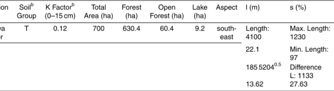
Table 1.Selected features of Watersheds I and II obtained from GIS and the past references.
Study area features Watershed I Watershed II
Location Antalya Center Antalya Center
Area (ha) 700 ha 800 ha
Annual Precipitation (mm) 1076.7 mm 1076.7 mm
Land Use Forest, open forest, lake Forest, open forest, lake,
orchard, agriculture, settlements, greenhouse
Elevation (m) 664 316
The total ratio of land use (%) 98.63 92.35
Vegetation Cover (%) 68 (except lake) 40 (except lake)
Soil Group and Texture ∗Red Mediterranean Soils (T), ∗Red Mediterranean
Clay Loam Soils (T), Clay Loam
Human Impact Almost no human impact Human impact
SED
7, 1731–1759, 2015Socio-economic modifications of the
Universal Soil Loss Equation
A. Erol et al.
Title Page
Abstract Introduction
Conclusions References
Tables Figures
◭ ◮
◭ ◮
Back Close
Full Screen / Esc
Printer-friendly Version Interactive Discussion
Discussion
P
a
per
|
Discussion
P
a
per
|
Discussion
P
a
per
|
Discussion
P
a
per
|
Table 2. Soil erodibility factor (K) in terms of Soil Group and some data from GIS and the past references of Watershed Ia. Red Mediterranean soils (T); slope length factor (l); and slope steepness factor (s).
Location Soilb K Factorb Total Forest Open Lake Aspect l (m) s (%) Group (0–15 cm) Area (ha) (ha) Forest (ha) (ha)
Antalya T 0.12 700 630.4 60.4 9.2 south- Length: Max. Length:
Center east 4100 1230
22.1 Min. Length: 97 185 52040.5 Difference
L: 1133 13.62 27.63
a
Watershed with almost no human impacts.
b
SED
7, 1731–1759, 2015Socio-economic modifications of the
Universal Soil Loss Equation
A. Erol et al.
Title Page
Abstract Introduction
Conclusions References
Tables Figures
◭ ◮
◭ ◮
Back Close
Full Screen / Esc
Printer-friendly Version Interactive Discussion
Discussion
P
a
per
|
Discussion
P
a
per
|
Discussion
P
a
per
|
Discussion
P
a
per
|
Table 3.Soil erodibility factor (K) in terms of Soil Group and some data from GIS and the past references of Watershed IIa. Red Mediterranean soils (T); slope length factor (l); and slope steepness factor (s).
Location Soilb K Factorb Total Dense Open Lake Orchard Agri- Settle- Green- Aspect
l s
Group (0–15 cm) Area Forest Forest (ha) (ha) culture ments house (m) (%) (ha) (ha) (ha) (ha) (ha) (ha)
Antalya T 0.12 800 408 8 2 255 68 11 48 south- Length: Max. Length:
Center east 3765 1230
22.1 Min. Length: 37 170 3620.5 Difference L:
558 13.05 14.82
a
Watershed with intensive human impact.
b
SED
7, 1731–1759, 2015Socio-economic modifications of the
Universal Soil Loss Equation
A. Erol et al.
Title Page
Abstract Introduction
Conclusions References
Tables Figures
◭ ◮
◭ ◮
Back Close
Full Screen / Esc
Printer-friendly Version Interactive Discussion
Discussion
P
a
per
|
Discussion
P
a
per
|
Discussion
P
a
per
|
Discussion
P
a
per
|
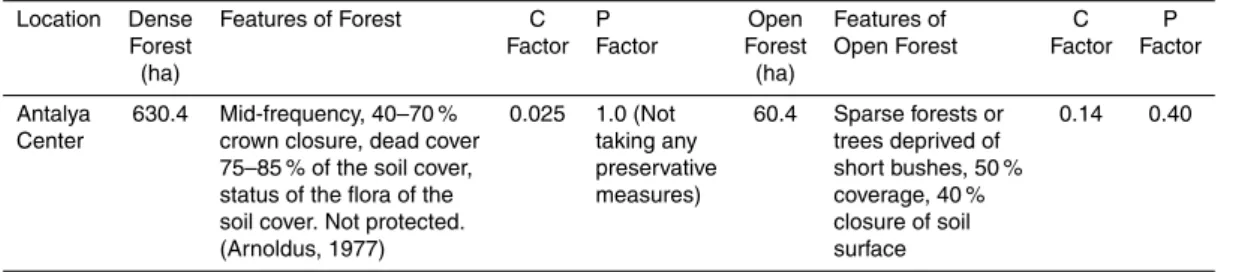
Table 4.Cropping management (C) and erosion control practice (P) factors for Watershed I (adapted from Balcı, 1996).
Location Dense Features of Forest C P Open Features of C P Forest Factor Factor Forest Open Forest Factor Factor
(ha) (ha)
Antalya 630.4 Mid-frequency, 40–70 % 0.025 1.0 (Not 60.4 Sparse forests or 0.14 0.40 Center crown closure, dead cover taking any trees deprived of
75–85 % of the soil cover, preservative short bushes, 50 % status of the flora of the measures) coverage, 40 % soil cover. Not protected. closure of soil
SED
7, 1731–1759, 2015Socio-economic modifications of the
Universal Soil Loss Equation
A. Erol et al.
Title Page Abstract Introduction Conclusions References Tables Figures ◭ ◮ ◭ ◮ Back Close
Full Screen / Esc
Printer-friendly Version Interactive Discussion Discussion P a per | Discussion P a per | Discussion P a per | Discussion P a per |
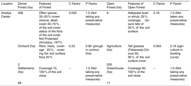
Table 5.Cropping management (C) and erosion control practice (P) factors for Watershed II (adapted from Balcı, 1996).
Location Dense Forest (ha)
Features of Forest
C Factor P Factor Open Forest (ha)
Features of Open Forest
C Factor P Factor
Antalya Center
408 Often sparse, 35–20 % crown closure, dead cover 40–70 % of the soil cover, status of the flora of the soil cover. Not Protected (Arnoldus, 1977).
0.055 1.0 (Not taking any preservative measures)
8 Adequate bush or shrub, 25 % coverage, clo-sure rate of 20 % of the soil surface
0.18 1.0 (Not taken any preservative measures)
Orchard (ha) Rare trees, age 25 %, cover-ing the soil surface flora 20 %
0.23 0.90 (plough in contour line) Agriculture (ha) Tall grasses (Fabaceae) Clo-sure 50, 95 % of the soil surface cover
0.003 0.16 (agri-culture in leveling curve) 2 255 Settlements (ha) Coverage 15, 100 % of the soil close
– 1.0 (Not taking any preservative measures) Greenhouse (ha) Coverage 90, 100 % of the soil close
– 1.0 (Not taking any preservative measures)
SED
7, 1731–1759, 2015Socio-economic modifications of the
Universal Soil Loss Equation
A. Erol et al.
Title Page
Abstract Introduction
Conclusions References
Tables Figures
◭ ◮
◭ ◮
Back Close
Full Screen / Esc
Printer-friendly Version Interactive Discussion
Discussion
P
a
per
|
Discussion
P
a
per
|
Discussion
P
a
per
|
Discussion
P
a
per
|
Table 6.Factors affecting the USLE and the soil loss amounts for Watershed I. Rainfall factor (R); soil erodibility factor (K); topographic factor (LS); cropping management factor (C); and erosion control practice factor (P).
Watershed I Land Use R K LS C P A Total soil loss Factor Factor Factor Factor Factor (t ha−1year−1) amounts in terms
of land use (t ha−1
year−1
)
Total Dense Forest
Area (ha) Forest (ha)
700 630.4 415.2 0.12 1.32 0.01 1.0 0.658 414.80
Open Open
Forest (ha) Forest
60.4 415.2 0.12 1.32 0.14 0.40 3.683 222.45
Total 4.341 637.26
SED
7, 1731–1759, 2015Socio-economic modifications of the
Universal Soil Loss Equation
A. Erol et al.
Title Page
Abstract Introduction
Conclusions References
Tables Figures
◭ ◮
◭ ◮
Back Close
Full Screen / Esc
Printer-friendly Version Interactive Discussion
Discussion
P
a
per
|
Discussion
P
a
per
|
Discussion
P
a
per
|
Discussion
P
a
per
|
Table 7.Factors affecting the USLE and the soil loss amounts for Watershed II. Rainfall factor
(R); soil erodibility factor (K); topographic factor (LS); cropping management factor (C); and erosion control practice factor (P).
Water- Land Use R K LS C P A Total soil loss
shed II Factor Factor Factor Factor Factor (t ha−1year−1) for total land
use area (t ha−1year−1)
Total Dense Forest Forest
area (ha) 408 415.2 0.12 0.714 0.02 1.0 0.7115 8449.68
(ha) Open Forest Open Forest
800 (ha) 8 415.2 0.12 0.714 0.18 1.0 6.4034 1490.88
Orchard Orchard
(ha) 255 415.2 0.12 0.714 0.23 0.90 7.364 54 651.60
Agriculture Agriculture
(ha) 68 415.2 0.12 0.714 0.003 0.16 0.0171 33.80
Settlement Settlement
(ha) 11 415.2 0.12 l: 13.05 – – – (potential erosion)
s: %14.82 1072.83
Greenhouse Greenhouse
(ha) 48 415.2 0.12 l: 13.05 – – – (potential erosion)
s: %14.82 4681.44
SED
7, 1731–1759, 2015Socio-economic modifications of the
Universal Soil Loss Equation
A. Erol et al.
Title Page
Abstract Introduction
Conclusions References
Tables Figures
◭ ◮
◭ ◮
Back Close
Full Screen / Esc
Printer-friendly Version Interactive Discussion
Discussion
P
a
per
|
Discussion
P
a
per
|
Discussion
P
a
per
|
Discussion
P
a
per
|
Table 8.The stages to decide a coefficient using USLE which represents the contribution of socio-economic factors impact on soil loss.
Sequence Mathematical process The result of each process
1 Se_E=A (Se/Wha) The amount of soil loss in the settlements 2 Pp_E=Se_E/total Pp The amount of soil loss from per person
Apn_E=Se_E/total Apn The amount of soil loss from per number of animals 3 Soc-e-F_E=Pp_E+Apn_E The amount of soil loss of socio-economic factors 4 Se_E_c=Soc-e-F/Se_E The contribution in the amount of soil loss of
the settlements
5 Soc-e-F_E/A=Coefficient Coefficient which corresponding to the average
=PP+PC values/PP value of all P and C factors impacted on
SED
7, 1731–1759, 2015Socio-economic modifications of the
Universal Soil Loss Equation
A. Erol et al.
Title Page
Abstract Introduction
Conclusions References
Tables Figures
◭ ◮
◭ ◮
Back Close
Full Screen / Esc
Printer-friendly Version Interactive Discussion
Discussion
P
a
per
|
Discussion
P
a
per
|
Discussion
P
a
per
|
Discussion
P
a
per
|
Table 9.Soil loss amounts without socio-economic factors in the USLE and with modified co-efficient with the relative differences.
Watershed I Land Use
Area (ha) Soil loss amounts
without
socio-economic factors in
the USLE (t ha−1yr−1)
Soil loss amounts with modified coefficient in the USLE (t ha−1yr−1)
Difference between
them (t ha−1
yr−1
)
and contribution of
coefficient (%)
A 0.008A+A (0.008A+A)−A
Dense Forest 630.4 10.35 10.4328 0.0828
Open Forest 60.4 16.57 16 703 0.133
Watershed II Area (ha) A 0.008A+A (0.008A+A)−A
Forest 408 20.71 20, 876 0.166
Open Forest 8 186.36 187, 851 1.491
Orchard 255 214.32 216, 035 1, 715
Agriculture 68 0.497 0.501 0.004
Settlement – – – –
SED
7, 1731–1759, 2015Socio-economic modifications of the
Universal Soil Loss Equation
A. Erol et al.
Title Page
Abstract Introduction
Conclusions References
Tables Figures
◭ ◮
◭ ◮
Back Close
Full Screen / Esc
Printer-friendly Version Interactive Discussion
Discussion
P
a
per
|
Discussion
P
a
per
|
Discussion
P
a
per
|
Discussion
P
a
per
|