Continuous multi-criteria methods for crop and soil conservation
planning on La Colacha (R´ıo Cuarto, Province of C´ordoba,
Argentina)
J. M. Ant´on1, J. B. Grau1, J. M. Cisneros2, F. V. Laguna3, P. L. Aguado1, J. J. Cantero2, D. Andina4, and E. S´anchez1 1E.T.S. de Ing. Agr´onomos, U.P.M., Av. Complutense 3, Madrid 28040, Spain
2Facultad de Ing. Agronom´ıa y Veterinaria, U.N. de R´ıo Cuarto, Pr. de C´ordoba, Argentina 3E.T.S. de Ing. de Caminos, Canales y Puertos, U.P.M., Ciudad Universitaria, 28040 Madrid, Spain 4E.T.S. de Ing. de Telecomunicaciones, U.P.M., Ciudad Universitaria, 28040 Madrid, Spain
Correspondence to: J. M. Ant´on (josemanuel.anton@upm.es)
Received: 28 November 2011 – Revised: 7 May 2012 – Accepted: 20 May 2012 – Published: 13 August 2012
Abstract. Agro-areas of Arroyos Menores (La Colacha) west and south of R´ıo Cuarto (Prov. of C´ordoba, Argentina) basins are very fertile but have high soil loses. Extreme rain events, inundations and other severe erosions forming gullies de-mand urgently actions in this area to avoid soil degradation and erosion supporting good levels of agro production. The authors first improved hydrologic data on La Colacha, eval-uated the systems of soil uses and actions that could be rec-ommended considering the relevant aspects of the study area and applied decision support systems (DSS) with mathematic tools for planning of defences and uses of soils in these ar-eas. These were conducted here using multi-criteria models, in multi-criteria decision making (MCDM); first of discrete MCDM to chose among global types of use of soils, and then of continuous MCDM to evaluate and optimize combined actions, including repartition of soil use and the necessary levels of works for soil conservation and for hydraulic man-agement to conserve against erosion these basins. Relatively global solutions for La Colacha area have been defined and were optimised by Linear Programming in Goal Program-ming forms that are presented as Weighted or Lexicographic Goal Programming and as Compromise Programming. The decision methods used are described, indicating algorithms used, and examples for some representative scenarios on La Colacha area are given.
1 Introduction
The study area La Colacha (Fig. 1) is a 423 km2tree-shaped configuration of basins, which is a gentle sub-basin of Ar-royos Menores, an agro-area (6753 km2) in a marginal Pam-pean northern region south of Province of C´ordoba, which is in the centre of Argentina. Arroyos Menores agro-area is spe-cial because it contains ramified basins, as the other east ar-eas of C´ordoba plains have more flat lands with larger rivers. La Colacha area corresponds to La Colacha-Cipi´on streams, confluent towards Santa Catalina stream, as is indicated in Fig. 1 with indications for sub-basins, drainage network and gullies. It has heights from 1000 to 560 m over sea level, and relief from smooth terrain east to rolling mountainous parts west with 16 % of total surface near an exterior vertical step of mountains west. For hydraulic planning the authors con-sidered La Colacha divided into 167 small sub basins.
September–November and March–April, with wet monsoon period including the Southern Hemisphere summer. The soils of Arroyos Menores are very fertile but suffer much from water erosions from wet monsoons, and especially by regres-sive erosion creating gullies, named here in Spanish c´arcavas, through them.
In La Colacha sub basin there are 87 active gullies, indi-cated roughly in Fig. 1, some with more than 3000 m length, sometimes increasing 500 m in one year. There is also hill-slope erosion (sensu Wilkinson et al., 2009) and high-bank or meander erosion in rivers showing poor geomorphic condi-tions (Brierkley and Fryirs, 2005). To restrain these erosions there are plans in Arroyos Menores for hydraulic manage-ment (HM), combining binding canals with cover, control of active heads, forestation of basis of gullies, and buffer bands of about 14 m wide.
The study area has undergone major soil-use and man-agement changes in recent years, moving away from mixed crop and livestock production systems to more agriculturally intensive uses (Degioanni, 2000), with an increasing pro-portion of soybean (Glycine max) in the crop rotation that is easily exported at international prices, territorial concen-tration, exclusion of small farmers and employment loss in the rural sector (Pengue, 2005). The combination of soy-beans and glyphosate to eliminate other plants allows lack of tillage, tending to reduce erosion risks; but undesirable plants may evolve resistance against glyphosate. The degra-dation of soils in these regions has been considered, such as by Zack et al. (2008); Paruelo (2011). The basin run-off and sediment export are responsible for negative effects or “externalities” that include sedimentation and the rise of the water table in lowland flood plains as well as flooding and damage to urban and road infrastructure. Other degradation processes in the basin include the loss of biodiversity in the mountains due to overgrazing, fire and non-native species, and episodic wind erosion events in agricultural soils. Inun-dations of lands, roads and villages occur also in lower areas. Hence the dangers of spoiling these delicate soils with loess have increased, and that makes the related studies and plan-ning important to maintain them in good state.
The La Colacha area has been cultivated for 150 yr, but with these relatively recent uses of land, soil has become eroded in part with regressive gullies not more than 10 or 15 m deep but destroying the flat surfaces and creating barriers that can severely spoil the area in the next 50 to 100 yr. Soil conservation (SC) dispositions and HM of the streams, also facilitating irrigation, can prevent or decrease the spoilage. But to be efficient, planning, funds, manage-ment and conservation combining public and private agents are required. The effect on soils depends also on the use of soils for agriculture, which has also economic and social ef-fects, and all require private or public actions, in not sim-ple policies to be defined by planning studies. The combined possible actions and effects open a panorama of DSS (deci-sion support systems) that were studied by the authors.
In these DSS considerations, the election of such “poli-cies” or actions is studied by considering their separate ef-fects on diverse natural or human venues. These policies need funding, and when they render diverse products that are sold, these are economic effects. They also have effects on the environment, including soils, erosion, nature occupy-ing it, and these will be called environmental effects. The ways to operate lands require considering different schemes of jobs, has effects on employment and on social patterns, and these are social effects. These diverse effects conduced the authors intending DSS towards MCDM (multi-criteria decision-making) formats, where “policies” became “alter-natives” and “effect fields” became “criteria”. The presence of diverse future scenarios with probabilities to be elicited was not felt important and hence the Bayesian or MAUT methods were not followed. The application of these MCDM enlarged the expert comprehension of what can be achieved with what sets of consequences.
The elaboration of rules usable for real management re-quired the use of continuous MCDM for La Colacha area, considering delicate combined sets of solutions with varied consequences. This required construction of what will be called “C-models” indicating, with a selected set of contin-uous variables, the possible elections for areas for different crops and numbers of works for HM and measures for SC as decision variables. Diverse restrictions were imposed by reality or to avoid major troubles, and consequences were evaluated from decision variables for a set of criteria. With the continuous MCDM, various ways of pointing to adequate solutions were tried in goal programming (GP) forms. The authors were inspired to use several of these forms, follow-ing diverse possible trends for decisions which correspond to the reality of planning in the presence of private interests and public regulation and investment.
Fig. 1. Location of study area “La Colacha” in Argentine Republic. The altitude map is from “Mapas Visiting”, much reduced. Includes a
view of basins, rivers, active gullies, roads. A north/south chain of old mountains lies west of study areas.
used in modern agricultural applications for optimising land-use strategies with multiple objectives (Agrell et al., 2004; Hengsdijk and van Ittersum, 2002; Nidumolu et al., 2007), for reservoir management (Chang et al., 1995), for trade-off analyses between agriculture, erosion and non-point-source pollution (Lakhsminarayan et al., 1995), for the optimisa-tion of crop distribuoptimisa-tions (Groot et al., 2007; Gonc¸alvez et al., 2007), for flood control problems (Simonovic and Akter, 2006) and for incentives for the application of river buffer strips (Borin et al., 2010). They are scarcer for Latin Ameri-can developing countries and for the Pampean Region; how-ever show-everal authors have searched for best alternatives of soil use with discrete multi-criteria for distinct regions of Chaco Salte˜no (Grau, 2003; Anton, 2006; Anton et al., 2010; Grau et al., 2007, 2008, 2009, 2010). Several works can be found on rural areas and roads (de Prada et al., 1994), local effects and policies (Cantero et al., 1998; de Prada and Penna, 2009), MCDM for small watershed (Zhen et al., 2007; Paneque Sal-gado et al., 2006), planning in agro-areas (Smith and McDon-ald, 1998) and for various objectives in agricultural policies
(Lakshminarayan et al., 1995). The conservation of soils in Argentina is backed by law (Law 8359, Arg., for conserva-tion of soils), but acconserva-tion is voluntary and scarce (Cristeche, 2009).
The considered general uses of soils were:
1. Agro-silva-pastoral use (ASP): combination of estab-lished forests, farming or pasture, depending on the ca-pability of soils; in the mountain parts by rationalised forests and pastures (Udawatta et al., 2002). It is good for environmental and social criteria but at a serious economic cost.
3. Intensive use (INT): more intensive cropping (Cisneros et al., 2005; Manuel-Navarrete et al., 2005). Tillage is normal here; irrigation is set if convenient. For cat-tle in Argentina there is actually tendency to feedlots where cattle is highly concentrated and nourished with balanced mixtures of maize, soybean and supplements; systems of waste recycling are necessary, needing exter-nal control. This use scenario is worse for environmen-tal considerations or criteria.
In these studies the considered crop area ranged from 52 to 87 %, the pasture from 13 to 28 % and forest (alley pas-ture) from 1 to 20 %. The crop ratios for soybean to corn ranged from 1:1 to 4:1. The first option was environmentally friendly, and the second represented an agricultural soybean-based intensification soybean-based on the current tendency in the Pampean region, using genetic modified soybean without tillage and eliminating previously undesirable plants with glyphosate. All these studies emphasised the necessity of:
1. Soils Conservation (SC): special measures for plots to prevent erosion, including horizontal tillage, and more specifically (for example) fifty to sixty-meter horizon-tal interval-graded terraces or pasture buffer strips se-lected due to their simplicity, economy and regional adaptability testing. They include binding canals with cover, control of active heads, forestation of basis of gullies, and buffer bands of about 14 m wide. As exam-ples, regulation ponds (micro-reservoirs) or constructed wetlands (Lasage, 2007) consisting of earth dam 3 m high with base-spillway discharge for peak runoff re-duction, gully control by head-cut, point of active retro-grade advance (Poesen et al., 2003), maybe by expen-sive concrete structural spillways or by bioengineering techniques (e.g., Morgan and Rickson, 1995), and gully-floor control.
2. Hydrological Management (HM): evolving basin-scale technical frameworks designed to reduce peak runoff, increase base flow, reduce sediment (and pollutant) dis-charge, control gully head-cuts and floor erosion, and stabilise the drainage network. This includes protection of streams, permanent or transitory, and rehabilitation of wetlands, mostly by dams. Eight types of micro-dams have been designed. At greater scale, micro-dams of some size and descents are to be protected from ero-sion; some already are. As examples, buffer/filter grass and forest riparian strips for permanent streams called “three-zone strip” (per Lovell and Sullivan, (2006), with grass strip bordering an agricultural zone sized with an “VFSMOD” model, intermediate cultivated forest strip and a variable-width native forest strip close to river bed) to reduce meander erosion. Another technique is grassed waterways as in Fiener and Auerswald (2006) sized for a peak runoff (estimated using “HEC-HMS”) covering temporal streams in the basin (180.3 km in
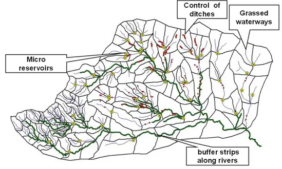
length). Figure 2 contains a global map indicating hy-draulic arrangements recommended by authors for La Colacha basin area.
The HM and SC were found rather necessary to control the spoiling of the lands by erosions that otherwise would spoil them long term, although they are rather non economic at short or middle term. These previous studies produced gen-eral indications. Therefore a more precise tuning of solutions for La Colacha, mostly of ACT kind, but of ASP kind in the mountainous west part marked at Fig. 1, and with degrees for HM and SC, was studied with continuous MCDM and is described as follows.
2 Application of continuous multi-criteria methods for La Colacha sub area
2.1 Continuous MCDM used, decision variables set, criteria, C or P-solutions
The authors have completed for La Colacha area a series of essays with continuous MCDM, emulating mostly Romero and Rehman (1989), Romero (1991, 1993). They indicate these methods as Goal Programming (GP), doctrine that uses constrained optimisation to consider adequately the re-ality and included multi-criteria, thus belonging to contin-uous MCDM, which is used also in industrial or economic fields. A condensed exposition of the methods employed will be presented, indicating formulae of optimisation, an elec-tion of variables and constraints, and a few results. Weighted Goal Programming (WGP) and Lexicographic Goal gramming (LGP) were considered, and Compromise Pro-gramming (CP) using Linear ProPro-gramming (LP) forms will be presented. To include them for GP, La Colacha planning problem was set as follows.
Solution definition for GP methods
C-solution
A complete set of policies and actions for the La Colacha region is considered a solution. Some solutions containing similar actions but differently located will be equivalent, and a set of such equivalent solutions will be indicated by the values of a set of decision variables (DV)xi, each one global
for the region, chosen to indicate the level of uses of soils and the intensity of measures in SM and HM for the whole region in a global way but enough detailed to determine the global effects for the region. The forest part in the area west of study site and with higher slopes in mountains will not be considered with the criteria variables (CV).
The effects of such a C-solution will be detected through the values of a well chosen comprehensive set of CV vbj,
Fig. 2. Proposal of Hydraulic arrangements for La Colacha basin. WM (water management), mainly to control erosions.
P-solution
Such a set of DV will indicate C-solutions that can be effec-tuated by actions on the region if the values of the DV are compatible, and if they are so, such set will define what will be called a P-solution. For this a set of technical constraints, TC on the DV will be elicited, containing the conditions that will have to be satisfied by the DV to be compatible, these TC being sufficient if all are fulfilled.
With GP methods optimising with LP, optimum P-solutions can be defined for defined scenarios of chosen GP methods, as will follow with some examples, obtained using a version of LINGO@ optimisation software to get the values of the DV and the CV using LP with real variables or contin-uous, most of them “non negative”. With LINGO, nonlinear equations could be used and integer or logical variables could be imposed.
General LP form for the GP used
For WGP form, it is exposed in (1) as a LP optimisation de-termining decision variables (DV) xi defining a P-solution
through minimizing an adequate sum for (1a) of weighted relative j-deviations (pj, nj), defined by (1b) for
“non-negative (pj,nj) ”, of the CV vbjfrom some knownj-goals gbj, the values vbjbeing defined linearly by TE in (1c) from
thexi. In the sum for (1a), the j-deviations are normalised
by dividing by positive vbj, taken often as rbj= gbj,
get-ting independence on units (that would be a problem ifpj
is taken). Thej-deviations are weighted in (1a) with some
positive weightswj andwj′, that in cases will bewj=0 or
w′j=0.
This general WGP form contains variables in general “non negative”, and will maybe include constraints TC in (1d).
Min
xi,vbj,nj,pj
P
j
(nj·w′j+pj·wj)
rbj
!
(1a)
for eachj,vbj+nj−pj=gbj (1b)
for eachj,vbj=P i
aij·xi,as TE, (1c)
with TC6i aik′ ·xi
(≤ or≥or =ck) . (1d)
(1)
In such WGP forms some of the positive or negativepj
deviations from thej-goals gbj are authorised but penalised to follow the real situation. Aj-criterion is evaluated by its CV vbj, and it may be of kind “more is better”, and then
its goal gbjwill be generally relatively great. Then the “non negative” measurenjof the unfavourable negative deviation
of its gbj from its goal appearing in (1b) will be minimized as indicated in (1a). In these cases, the corresponding pos-itive deviationpj will likely be favourable and will not be
minimized, setting in general for it wj=0, and will be 0
likely due to the high value of the corresponding gbj. And inversely, if aj-criteria measured by its CV vbj is of kind
“more is worse”, then its goal gbj will be relatively small, and the positive favourable deviation pj of its vbj from it
will be minimized with (1a). Then the correspondingnjwill
likely be favourable and not minimized, setting in general for itw′j=0, and it will be 0 likely due to the low value of its
could be sensible for both senses and both deviations (pj,
nj) would have to be minimized with (1a), especially when
the GP methods are applied in other fields of research.
Decision variables set (DVS)
To define C-solutions for La Colacha sub-area the authors designed the following DVS of DVxifor (i= 1, ..., 13), hence
withm=13. They indicate numerically the use of soil and the level of the SC and HM with some level of precision, but to define a valid C-solution they will have to follow the TC defined later. This adopted DVS is:
A. Corn without the SC area (ha), status quo soil management condition,x1,
B. Corn with the SC area (ha),x2,
C. Soybean without the SC area (ha), status quo soil management condition,x3,
D. Soybean with the SC area (ha),x4,
E. Pasture for cattle production area (ha),x5,
F. Pasture for buffer strip area (ha),x6,
G. Pasture for grassed waterway area (ha),x7,
H. Forest-grazing mixed area (agro-forestry use, ha),x8,
I. Forest riparian buffer area (ha),x9,
J. Forest to gully floor erosion control area (ha),x10,
K. Regulation ponds (N◦),x11,
L. Active gully head-cut (N◦), that is, non-controlled,x12,
M. Controlled gully head-cut (N◦),x13.
Criteria variables set (CVS)
Such a C-solution for La Colacha will be qualified for deci-sions, in a situation of multi-criteria type, by a CVS set of CV vbj, with (j= 1, ..,6), hence withn=6, as follows:
1. Peak run-off (PRU), vb1= peak runoff in [l s−1.ha−1], and in [l s−1unit−1] to regulation ponds, negative if av-erage reduction of peak run-off, favourable.
2. Erosion (ERO), vb2= annual erosion in [Mg ha−1] or [Mg unit−1] for gullies; a negative sign in the controlled gully category indicates a reduction in the erosion pro-duced by each head-cut control work.
3. Sediment production (SED), vb3= sediment production [Mg ha−1]; a negative sign indicates that the works re-tain sediment and prevent it from reaching a river, or in the controlled gully category a reduction in the sed-iment production. There is no SED retention in a pond because in designs the disposition of spillway is at the lowest point of the dam structure.
4. Investment (INV), vb4= investment in US $ y−1, (y) be-ing for “year”.
5. Benefit (BEN), vb5= annual benefit in gross margin (US $ y−1).
6. Employment (EMP), vb6= employment generation (number of jobs).
Due to their nature, the PRU, ERO, SED and INV criteria are of kind “more is worse” and are to be optimised towards their minima, whereas the BEN and EMP criteria are of kind “more is better” and are to be optimised towards their max-ima.
2.2 Technical Equations and Technical Constraints (TC) proposed for La Colacha
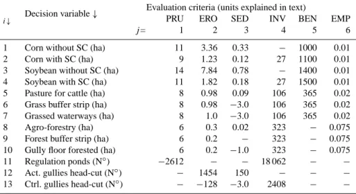
Technical equations matrix (TE)
CV are function, as said, of the DV by technical Eq. (1c),
vbj=P i
(aij·xi), where the aij are the elements TEij of
a TE matrix. The authors have elicited for case studies the matrix TE, adopting decision variables and evaluation cri-teria as they are in Table 1 to represent the impacts for C-solutions of each DV xi on each CV vbj, in fact for valid
obtained for a project from the cost for his lifetime, oppor-tunity interest rate under Argentine conditions was taken as 12 %. For BEN, they used about margin in a typical exploita-tion (de Prada et al., 2008). The crop-weighted gross margin and the cost values were considered at 2010 prices. Monocul-ture may increment BEN and degrade more soil, but it influ-ences farmers’ decisions (Groot et al., 2007; Gil et al., 2008). EMP was estimated following Llach et al. (2004), depending on type of activity and on the yields of the crops. The ef-fects of SC, crop rotation and hydrological management on the PRU, ERO and SED were significant. Forest, pond and gully control costs were important components of the INV. SC affected BEN, causing a 5 % increase in crop production, which improved the water economy, and forestry had a strong effect on employment.
Technical Constraints (TC)
As said, to get a valid P-solution the adopted DV and the CV of a C-solution will have to also satisfy TC equations as for (1d) of the GP form in (1). The authors have proposed the following set of TC.
First the DV will be limited as:
a. PRU constraint, vb1: The peak runoff must be less than 477 000 l·s−1; the maximum value was simulated for the more intensive soil-use scenario, methods in Cis-neros et al. (2011). This is a value that reflects a basin condition of maximum degradation or hydrological destabilisation. vb1≤477 000.
b. ERO constraint, vb2: The annual erosion cannot be over 232 542 Mg, corresponding to the erosion estimate for 90 % soybean soil cover without SC (over 34 246 ha of agricultural soils) for a 1.5 % slope condition; from the authors, methods resumed in Cisneros et al. (2011).
vb2≤232 542.
c. SED constraint, vb3: For a similar condition of soil use, the maximum sediment delivered was about 48 000 Mg y−1. vb3≤48 000.
d. INV constraint, vb4: The maximum value was estimated by the authors at US $ 1 000 000, corresponding to completely developed work schemes (SC and HM with ASP). In fact, this means that there was no investment restriction. This value was established in order to ex-plore the minimum investment required to optimise the solutions obtained by the various MCDM tested.
vb4≤1 000 000.
(in 2009 average values, US $ 172 ha ); the value for the entire basin agricultural area was US $ 5 883 287.
vb5≥5 883 287.
f. EMP number constraint, vb6: The employment could not be less than the actual value, estimated as 382 jobs.
vb6≥382. This is a judgement from authors, interpret-ing local sentiment.
Moreover the DV will satisfy the 12 constraints that follow, the first of them is the limit for the sum of areas:
g. Agricultural land area constraint,k=7. The total area under different soil-use regimes could not be greater than the agricultural land availability (34 246 ha). This results in:x1+x2+x3+x4+x5+x6+x7+x8+x9+x10+ 109·x11+ 2·x12+ 0.4·x13≤34 246.
The other 11 constraints contain rational limitations ex-pressed from the “expert knowledge from authors”, which detected constraints necessary for the validity of a C-solution:
h. Number of regulation ponds constraint, k=8. Forty-seven was the maximum number of ponds simulated, which was a function of the topographically suitable sites in the basin.x11≤47.
i. Gully number constraint sum,k=9. Eighty-seven gul-lies were registered in the basin; accordingly, no solu-tion greater than this number was logical.
x12+x13≤87.
j. Grassed waterways area constraint, k=10. The maxi-mum area measured with grassed channels was 344 ha, corresponding to the soil-intensive use peak runoff. x7≤344.
k. Grass buffer strip area constraint, k=11. The maxi-mum required buffer area to reduce sediment charge by 75 % in the basin was 250 ha.x6≤250.
l. Riparian forest area constraint,k=12. The three-zone buffer strip included 6 m of forest, which totalled 99 ha, the maximum necessary to protect the riverbanks from meander-type erosion.x9≤99.
Table 1. Technical Equations matrix TEij=aij for La Colacha basin.
Decision variable↓ Evaluation criteria (units explained in text)
i↓ PRU ERO SED INV BEN EMP
j= 1 2 3 4 5 6
1 Corn without SC (ha) 11 3.36 0.33 − 1000 0.01
2 Corn with SC (ha) 9 1.23 0.12 27 1100 0.01
3 Soybean without SC (ha) 14 7.84 0.78 − 1400 0.01
4 Soybean with SC (ha) 11 1.82 0.18 27 1500 0.01
5 Pasture for cattle (ha) 8 0.98 0.09 106 365 0.02
6 Grass buffer strip (ha) 8 0.98 −3.0 106 365 0.02
7 Grassed waterways (ha) 8 1.0 −3.0 106 365 0.02
8 Agro-forestry (ha) 6 0.3 0.02 323 − 0.075
9 Forest buffer strip (ha) 6 0.2 − 323 − 0.075
10 Gully floor forested (ha) 6 0.2 −1.0 323 − 0.075
11 Regulation ponds (N◦) −2612 − − 18 062 − −
12 Act. gullies head-cut (N◦) − 1454 150 − − −
13 Ctrl. gullies head-cut (N◦) − −128 −3.0 2408 − −
n. Forest-pastoral (alley pasture) area constraint, k=14. This was arbitrarily set to a maximum forest area of 18 % of the agricultural lands to simulate a soil use of 18 % forest, 20 % pasture and 52 % agriculture. This was a simulated soil-use distribution in a hypothetical agro-forestry crop production system.x8≤6152.
o. Rotation constraint or maximum soybean area,k=15. A 4:1 soybean-to-corn ratio was set as the maximum soybean soil-use, which represents the current trend of soil-use intensification in the remainder of the Pampean region.x3+x4≤22 345.
p. Minimum agricultural area constraint,k=16. This was set to the equivalent of 52 % of the total agricultural area.x1+x2+x3+x4≥17 808.
q. Minimum pasture area constraint,k=17. Considering the actual non-arable lands (riverbanks, dunes and farm-ers’ houses), this was estimated as 13 % of the total agri-cultural basin area.x5+x6+x7+x8+x9≥4451. r. Non-use area constraint,k= 18. All basin surfaces were
required to be in use. This constraint was included in order to obtain solutions with no “empty” areas; it was set to 34 000 ha to allow some calculation flexibility and to provide minimal inconsistency in the calculations of the total surface with different soil uses.
x1+x2+x3+x4+x5+x7≥34 000.
2.3 Pay-off matrix (PM) for La Colacha, ideal and anti-ideal values
With the precedent assumptions to define P-solutions, to set a LP of form as in (1) some ideal and maybe some anti-ideal values are required in many of the GP methods, especially to set the gbj in (1a), and they were obtained calculating the pay-off matrix, indicated in Table 2 as (PMj′j) square matrix of order 6. For eachj′of (j′= 1, ... , 6) the best obtainable value in GP for the CV vbj′is reached by optimising it in line (1a) of a LP form of type (1), getting a LP form as in (2) that will give six vbj in results that are copied as PMj′j=vbj; and from them getting the GP best vbj′forj =j′. A Pay-off matrix PM is hence obtained, indicated in Table 2, with the best GP obtainable value for each j′, vbj′=PMj′j′, in its diagonal, which is called thej′-ideal value idbj′ for the CV of indexj′. Each columnjof PM contains six values PMj′j for the single criteriajin such special optimisations, and the worse one, observed for file j′ = j′′, is taken as anti-ideal value adbj=PMj′′j for the CV of indexj (see Table 2). For each of these six LP of form (2), optimising thej′ goal or criteria value vbj′, Table 3 indicates in each column the values obtained for the 13 CVxi, left blank if they are 0.
In (2a), Min or Max will be Max if thej′-criteria of “more is better type”, Min if of “more is worse type”; and in (2c) and (2d), (j,j′= 1, ...., 6) and (i= 1, ...., 13),
For eachj′:
Min or Max xi,vbj
vbj′
, (2a)
for eachj,vbj=Pi (aij·xi),as TE, (2c)
with the adopted TC for the(xi,vbj) (2d)
(2)
terioration of La Colacha area each year. Employment EMP then becomes as worse in PM at the minimum value imposed in constraints TC. Benefits (BEN) could be optimised by pro-ducing maximum valuable crops, at least in the first series of years that have weight in BEN, due mainly to higher surfaces used to produce crops and none for SC. But then in the long term the production capacity would be successively reduced by accumulation of negataive environmental effects destroy-ing part of the agro surface, which is clearly a really bad policy.
2.4 Use of the GP continuous MCDM for La Colacha area
2.4.1 P-solutions for La Colacha obtained by GP optimisations in some scenarios
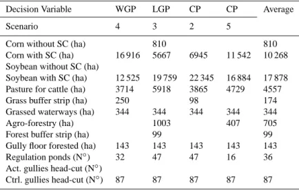
With the precedent assumptions the authors in a campaign of trials defined recommended P-solutions for La Colacha area, good in the sense that some characteristics were optimised or kept good in a given GP scenario. The precedent defini-tion of P-soludefini-tions was set following expert consideradefini-tions about the effects of use of soils on reality, including the ac-ceptation by farmers. In each GP scenario a LP of forms as in (1) was set and solved to get a P-solution, and some of these solutions are indicated in Tables 4 and 5 by their obtained CV variables.
Table 4 contains columns with values of the 13 decision variables DV that describe the recommended use of soil by the measure of surfaces used for each crop or the number of works to be done, and each column corresponds to an sce-nario corresponding to the GP method used (WGP, LGP, and two to CP) to obtain it, and a last fifth column was filled with averages of non null elements from the precedent columns. The soybean and the corn appear important in solutions with different proportions between them, but with SC for both, al-most absolutely in Table 4 scenarios.
2.4.2 Weighted Goal Programming (WGP) methods
For WGP each LP has a form following (1), which contains optimisation items as indicated in (1a) and (1b). The weights, which in general are normalised so as to add 1, assess differ-ent relative importance to the deviations from goals of the CV. All the GP used by the authors adopt some WGP forms, and with them at first the authors did general trials.
From them, column 1 of Table 4, labeled as Scenario 4, contains the 13 CV values obtained with a WGP method. For it the adopted weights wj were 0.66 for INV and
0.066 for the other criteria variables. In this WGP the goals as {182,29231,1485,385000,9278275,491} at near the t=90 % level from Anti-ideal to Ideal values, defined
Other “iterative” solutions with other weights and goals were found to require much lower surface with soybean and will be not accepted by farmers. These scenario results were analysed in the actual decision-maker context, simulating a participatory process as in Nidumolu et al. (2007). This approach was done for the basin agricultural area, exclud-ing mountainous areas. It was found that this multi-criteria method is not efficient for the inclusion of agro-forestry and does not provide an adequate approach to locate forests, and for that other land-capability objective approaches should be used for this purpose as in Sant´e Riveira et al. (2008). The authors had obtained some results for that with discrete MCDM.
In relation to the economic indicators that assess the via-bility of agro-forestry projects, the NPV (net present value) or IRR (internal rate of return) can be complementary as in Hajkowicz (2008). These extensions would require valuation of criteria in monetary units as USD, and effects at long term may be underestimated, as those in PRU, ERO, SED, includ-ing degradation of lands by gullies erosion. But this may use-fully consider limits in annual budgets for investments, pri-vate and public, maybe also in optimisations, and avoid some non-profitable solutions initially too expensive.
2.4.3 Lexicographic goal programming (LGP) methods
Following Romero (1989, 1993), in this LGP approach a group of higher priority goals is satisfied first and their CV are determined and then fixed, and the remaining goals are then addressed in groups in a defined priority order. In their research the authors used six successive groups, each one with a single CV goal, and the aspiration levels were used similarly as for the WGP, with goals gbj and weightswj.
In each scenario, six LP from a form derived from (1) were successively used, optimising successively in each step only the deviations (pj,nj) from its knownj-goal gbj of a
sin-gle CV vbj for the single corresponding j, and fixing the
obtained values of (pj, nj), and hence its CV vbj from
its (1b) vbj+nj−pj=gbj, for the following optimisations.
In the prior steps the deviations tend to get the value 0. Three scenarios with variable lexicographic orders were assessed, considering the pay-off matrix results and the constraints im-plicit in its analysis:
– Scenario 1. Order: 1st BEN→2nd PRU→3rd INV→
4th EMP→5th ERO→6th SED
– Scenario 2. Order: 1st ERO→2nd BEN→3rd EMP→
4th SED→5th PRU→6th INV
– Scenario 3. Order: 1st BEN→2nd EMP→3rd ERO→
Table 2. Pay-off matrix PM or for the criteria of the La Colacha case study. To obtain eachj′-line, the CV vbj′ was optimised, getting values. In diagonal, in bold, bestj-ideal values; inj-column, in italic, worsej-anti-ideal value.
Optimisation
for↓j′
In bold, ideal values ←j-Criteria, from (14)→ In italics, anti-ideal values
PRU (m3s−1) ERO (Mg y−1) SED (Mg y−1) INV (US $ y−1) BEN (US $ y−1) EMP (N◦)
Min PRU 1 165 67 510 6221 810 556 6 510 097 496
Min ERO 2 232 26 574 2261 716 264 6 528 815 500
Min SED 3 291 26 676 1350 635 777 6 533 495 519
Min INV 4 430 204 362 20 020 170 371 10 336 312 387
Max BEN 5 348 43 029 3216 380 724 11 102 209 387
Max EMP 6 290 26 401 2236 662 389 6 491 379 545
Table 3. Values of the DV by optimising the CVj′with GP to get the pay-off matrix PM. Columnj′contains the DV, and the CV are in the
j′file of matrix PM in Table 2. Values that are 0 are indicated with a blank.
Decision variablexi i′↓
j′-Criteria for optimization to get the xi,j’-columns
Min PRU Min ERO Min SED Min INV Max BEN Max EMP
Corn without SC (ha) 1 7404
Corn with SC (ha) 2 17 808 17 808 17 808 7415 17 808
Soybean without SC (ha) 3 22 345
Soybean with SC (ha) 4 22 345
Pasture for cattle (ha) 5 15 548 15 748 15 548 4107 3857 15 348
Grass buffer strips (ha) 6 250 250
Grassed waterways 7 344 344 344 344 344 344
Agro-forestry (ha) 8 711
Forest buffer strip (ha) 9 99
Gully floor forested (ha) 10 143
Regulation ponds (N◦) 11 47 22 1
Act. gullies head-cut (N◦) 12 26 7
Ctrl. gullies head-cut (N◦) 13 61 87 87 80 87 87
In scenarios 1 and 3, the farmer’s economic interest was prioritised first, whereas in scenario 2, an environmental criterion was optimised first. In scenarios 2 and 3, the INV criterion was optimised ultimately ex professo to avoid a “bottleneck” constraint, and these scenarios could assess the level of investment required and the corresponding achieve-ment level for the other goals. In Table 4 the column LGP (Scenario 3) indicates results for scenario 3.
2.5 Use of the compromise programming (CP)
The resolution of CP (see Zeleny, 1982; Romero; 1989, 1993) consisted of obtaining a minimum distance in the CV space to an ideal point for all the criteria together. This point is defined by the n ideal values idbj, with
n=6 for the research in this paper. The distance concept in MCDM methods is a surrogate of human preferences. Three typical Minkowsky distance functions or p-metrics were used, p=1, p=2 andp= ∞, from the admissible withp≥1, and different scenarios were performed varying
preferences in the criteria assessed by the values of the as-signed weights simulating decision-maker preferences. For this the schema (1) is used, without (1b), and optimising in-stead of (1a) ap-distance to the ideal point in the CV space of form
Min xxi,vbj
6j
(vbj−idbj)·wj
(idbj−adbj)
p1/p
. (3)
This distance was mostly used for p=1 and p=2, as usual, and also forp= ∞assuming that then it is
Min xxi,vbj
Supj
(vbj−idbj)·wj
(idbj−adbj)
. (4)
Scenario 4 3 2 5
Corn without SC (ha) 810 810
Corn with SC (ha) 16 916 5667 6945 11 542 10 268 Soybean without SC (ha)
Soybean with SC (ha) 12 525 19 759 22 345 16 884 17 878 Pasture for cattle (ha) 3714 5918 3865 4729 4557
Grass buffer strip (ha) 250 98 174
Grassed waterways (ha) 344 344 344 344 344
Agro-forestry (ha) 1003 407 705
Forest buffer strip (ha) 99 99
Gully floor forested (ha) 143 143 143 143 143
Regulation ponds (N◦) 32 47 47 16 36
Act. gullies head-cut (N◦)
Ctrl. gullies head-cut (N◦) 87 87 87 87 87
Table 5. Results from CP of nine scenarios for the DV in La Colacha.
Decision Variables Case study – Scenarios
Scen.1 Scen.2 Scen.3 Scen.4 Scen.5 Scen.6 Scen.7 Scen.8 Scen.9
Metric : p=1 p=2 p= ∞
Weight in – ERO PRU – ERO PRU – ERO PRU
Corn without SC (ha) 6120 394 28 742
Corn with SC (ha) 7415 6945 29220 1727 11 542 20 932 13 239 23 957 365
Soybean without SC (ha) 11 469 5222
Soybean with SC (ha) 22 345 22 345 22 345 16 884 2433 0.5
Pasture for cattle (ha) 3395 3865 3865 9083 4729 3659 8447 4118 4392
Grass buffer strip (ha) 98 98
Grassed waterways (ha) 344 344 344 344 344 344 344
Agro-forestry (ha) 469 377 407 205 269 90
Forest buffer strip (ha) 99 99 99 99 99 58
Gully floor forested (ha) 143 143 143 143 143 143 143 143
Regulation ponds (N◦) 47 47 9 16 26 19 19 47
Active gullies (N◦) 9 19
Controlled gullies (N◦) 87 87 87 87 87 87 78 87 68
were found the best forp. The CP was found good to con-sider environment variables, as in fact it makes a balance be-tween the effects of them. In Table 4 the results for the CP methods are in two columns (CP, Scenario 2 and Scenario 5), for two scenarios with good results designed in view of the precedents.
All the scenarios showed with the GP methods very differ-ent crop rotation efficidiffer-ent points, from an SC-based soybean almost monoculture to corn monoculture without SC adop-tion, which was discarded as it probably would be rejected by both farmers and environmentalists (low BEN, SED and ERO goal achievement). In relation to the HM, the solutions consistently demonstrate that gully head-cut control, gully floor forestation, ponds and grassed waterways should be present in all HM plans. Forest buffer strips, and especially
3 Results and discussion of continuous methods
It can be seen globally that the continuous MCMD offers a tool to define valid P-solutions for La Colacha, and to se-lect optimum P-solutions by LP in various scenarios for GP, aiming to find policies in the crops and in the measures to conserve the La Colacha study area. Such best solutions de-pend on hypotheses and on the GP model used by analysts. So the authors have obtained methods of interactive analysis that they think conform to realities and therefore may be an aid to set and evaluate coherent solutions in planning.
Some relevant combined consequences are observed. The ideal points (Table 2) show the conflict level in relation to the environmental, economic and social criteria used. The optimal values of the environmental criteria (PRU, ERO and SED) matched the worst values for the economic criteria, es-pecially for INV and, to a lesser extent, for BEN. The ideal values of the two economic variables INV and BEN had the least conflict, because the increases in INV are assumed to be in high part for works to avoid erosion by SC and HM. The value for BEN obtained at the ideal point of INV was quite similar to the BEN maximum. Among the economic criteria, BEN was more compatible with a better environmental con-dition than was INV; that is, optimisation of BEN generated minor environmental degradation compared to INV optimi-sation. In the same sense, the conflict between the environ-mental and social criteria was minimal.
Diverse real policies could be made in the future for these areas, and they will depend on the demand and prices of products. Pasture will be limited as from Table 5 results, Grassed waterway will be much recommended, and Grass buffer strip and Forest buffer strip much less. Agro-forestry may be increased slightly, which was discussed between sce-narios. In any case, the gullies must be better controlled than now in a general effort to reduce the high actual level of ero-sion. This conclusion resulted for all scenarios, as is visi-ble in Tavisi-ble 4. As other results from Tavisi-ble 5 mainly, al-ternatives that minimize the PRU and ERO were consistent with a basin HM design fully developed with grassed water-ways, regulation ponds and gully control, whereas the SED optimal management incorporated buffer grasses and river and gully forests. The unique alternative that considers some minimum agro-forestry areas is the optimisation of the EMP criterion, clearly demonstrating the employment generation of this activity, although it was suboptimal for the remaining criteria. In normative terms, the data assessment suggests that optimal solutions should aim to adopt integral SC and HM strategies to solve environmental conflicts that will unfold in medium or long-term economics. The management plan more attractive to farmers and land-renters, in which the BEN was optimised, was SC-based with a 3:1 ratio of soybeans to corn and partial HM works (complete grassed buffers and waterways and head-cut gully control). This efficient alter-native appeared as the first approximation of “best” opti-mised strategy for soil use as tested with continuous
multi-criteria methods. The crop rotations are realistic, although they will require an intense SC-adoption policy and an ex-haustive analysis of private and public investment-sharing strategy. With a first basic data set, the authors demonstrated that the actual, and probably the future, productive strategy is supported by a rationale of minimizing INV and maximis-ing BEN, a strategy that is obviously market-oriented and based exclusively on private economic criteria (Prato and Herat, 2007); but it is in strong conflict with all environmen-tal and social criteria. The principal real constraints seem to be the INV possibilities and degree and dynamics of farmers’ adoption of SC in crop technology. But this SC is necessary to avoid successive erosions that, if not limited by SC and HM, will degrade the area and reduce productions, and hence BEN, and also EPM, for the middle term.
The continuous methods showed the possibility of thor-ough analysis on the combined effects of the levels of actions related to types of crop, care of environment, and measures for SC and HM. They allow considering combined effects that are poorly apparent otherwise, so it is a valid tool to be incorporated in studies and in planning. But diverse sets of premises are reasonable, and the results are not unique, and they depend especially on the relative importance imposed of each criterion. These methods are hence more a tool to consider consequences on proposed uses of soils of study ar-eas than to fix single optimum decisions. These continuous MCDM are a tool that offers a better view of the consequence of technical and economical external variables on optimum solutions.
4 Conclusions
The information and methods indicated in this paper are appropriated as aid for hydro-basin planning. The paper presents extracts of significant research by authors, and in-dicates the techniques used for La Colacha area with con-tinuous MCDM that offer mostly interactive aiding tools for planning. The results put in evidence the interest of having conservation policies by public and private combined ac-tions, maybe with subvenac-tions, to improve the state of the studied basins that are differently degraded. GIS, methods of hydrology and those of soil erosion control were handled in the first steps of research, aiding to provide some general information for this paper. The exposed methods could ob-tain priorities of actions and of timing. The conservation and amelioration of lands will require actions for SC and for HM, after inspection on the state of plots and soil water content.
(HM) works to conserve the high quality of the surface of soils that can be easily spoiled without them in a matter of some decades.
In the research an ample inspection on the state of art of DSS models for such planning was effectuated, and part of it is indicated in the references. The results in this paper are being used in a regional planning project promoted by public entities in Argentina, aiming at rural planning. The ways to do them, how to pay for them by land owners or by public agencies, and the legal ways to get them progressively en-acted in the following years or decades will be a new source of studies that could be aided with extension of the continu-ous MCDM presented in this paper.
Acknowledgements. This study was performed with funds from the UPM in a “Proyecto Semilla 2009” between the UPM and the National University of R´ıo Cuarto (UNRC), from a research project funded by the UNRC, from a doctoral fellowship supported by the Carolina Foundation and by the Ministry of Science, Technology and Productive Innovation of the Argentine Republic. It was partially support by CICYT project AGL2006-12689/AGR and AGL2010-21501/AGR. Comunidad de Madrid contributed through projects CCG07-UPM/000-1995 and CG07-UPM/AMB-1998.
Edited by: A. M. Tarquis
Reviewed by: two anonymous referees
References
Agrell, P. J., Stam, A., and Fischer, G. W.: Interactive multi-objective agro-ecological land use planning: The Bungoma re-gion in Kenya, Eur. J. Oper. Res., 158, 194–217, 2004.
Anton, J. M., Grau, J. B., Tarquis, A. M., and Sanchez D. C.: MCDM Methods for Territorial Services Planning in an Andine rural area, WAC 2006, Budapest, Hungary, 24–27 July 2006, IISSCI 13, 5, TSI Press, San Antonio TX (Texas), USA, 2006. Anton, J. M., Grau, J. B., Tarquis, A. M., Cisneros, J. M., and
Andina, D.: Decision theories used in planning of areas around La Colacha basin in C´ordoba (Argentine) considering natural and human hazards, Geophys. Res. Abstr., 12, EGU2010-14849, 2010.
Borin, M., Passoni, M., Thiene, M., and Tempesta, T.: Multiple functions of buffer strips in farming areas, Eur. J. Agron., 32, 103–111, 2010.
Brierkley, G. J. and Fryirs, K. A.: Geomorphology and river man-agement. Applications of the river styles, Framework. Blackwell Publishing, Oxford, UK, 398 pp., 2005.
Bryan, B. A. and Crossman, N. D.: Systematic regional planning for multiple objective natural resources management, J. Environ. Manage., 88, 1175–1189, 2008.
Cantero, A., Bricchi, E., Becerra, V. H., Cisneros, J. M., and Gil, H.: Zonificaci´on y descripci´on de las tierras del Departamento R´ıo Cuarto (C´ordoba), Ed. UNRC, Rio Cuarto, Argentina, 80 pp., 1986.
un manejo sustentable, Ed. UNRC, Argentina, 119 pp., 1998. Chang, N.-B., Wen, C. G., and Wu, S. L.: Optimal management
of environmental and land resources in a reservoir watershed by multi-objective programming, J. Environ. Manage., 44, 145–161, 1995.
Cisneros, J. M., Cantero, G. A., Gonz´alez, J., De Prada, J., Reynero, Ma. Gil, H., Degioanni, A., Cholaky, C., Becerra, V. H., and Mongi, F.: Identificaci´on de los focos activos de erosi´on h´ıdrica lineal y programa de control de erosi´on en la cuenca media y alta del arroyo Santa Catalina (arroyos La Barranquita, Cipi´on y La Colacha), Informe Final Protocolo Espec´ıfico de Cooperaci´on Direcci´on Provincial de Agua y Saneamiento, edited by: (DI-PAS) – UNRC/FAV. 20 pp, y anexos (cat´alogo de pr´acticas y car-togr´afico), 2005.
Cisneros, J. M., Cantero, A., Degioanni, A., Becerra, V. H., and Zubrzycki M. A.: Producci´on, Uso y Manejo de las Tierras, in: Percepci´on econ´omica y visi´on de los productores agropecuarios de los problemas ambientales en el Sur de C´ordoba, edited by: de Prada J. D. and Penna, J., Instituto de Econom´ıa y Sociolog´ıa INTA, Argentina, 57–73, 2008a.
Cisneros, J. M., Cantero G. A., Degioanni, A., Angeli, A., Gonz´alez, J. G., De Prada, J. D., Reynero, M. A., Gil, H. A., Be-cerra, V. H., and Esp´osito, G.: Uso del suelo, erosi´on y deterioro de caminos rurales: el caso de la cuenca Suco-Moldes-Mackenna (Cordoba), in: XXI Congreso Argentino de la Ciencia del Suelo. Potrero de los Funes (San Luis), 13–16 May 2008b.
Cisneros, J. M., Grau, J. B., Ant´on, J. M., de Prada, J. D., Cantero, A., and Degioanni, A. J.: Assessing multi-criteria approaches with environmental, economic and social attributes, weights, pro-cedures: A case study in the Pampas, Argentina, Agri. Water Manage., 98, 1545–1556, 2011.
Cristeche, E. R.: Valoraci´on econ´omica de los efectos externos de la erosi´on h´ıdrica sobre la infraestructura de caminos rurales en el Sur de la provincia de C´ordoba, Argentina, Ph.D. thesis, Facultad de Ciencias Econ´omicas, Universidad de Buenos Aires, 2009. Dabney, S. M., Yoder, D. C., Bingner, R. L., and Vieira,
D. A. N.: Predicting runoff for a RUSLE2 ephemeral gully calculator, in: tucson.ars.ag.gov/isco/isco15/pdf/DabneyS PredictingrunoffforaRUSLE2.pdf, 2008.
De Prada, J. D., Boretto, J., Ferrando, M., Garcia, A., Olmos, J., and Marcelo S.: Proyecto de conservaci´on y ordenamiento de tierras General Deheza. Master of Art, Universidad Nacional de C´ordoba, C´ordoba, 1994.
De Prada, J. D., Lee, T. S., Angeli, A. R., Cisneros, J. M., Cantero, G., and Cantero, A.: An´alisis multicriterio de la conservaci´on de suelo: Aplicaci´on a una cuenca representativa del centro Ar-gentino. Revista Iberoamericana de Econom´ıa Ecol´ogica, 9, 45– 59, http://www.redibec.org/IVO/rev9 04.pdf, 2008.
De Prada, J. D. and Penna, J.: Percepci´on econ´omica y visi´on de los productores agropecuarios de los problemas ambientales en el sur de C´ordoba, Argentina. Estudios socioecon´omicos de la sus-tentabilidad de los sistemas de producci´on y recursos naturales. N◦08, IES INTA, 93 pp., 2009.
los Recursos Agrarios. Aplicaci´on a la cuenca Santa Catalina (Argentina). In: Tecnolog´ıas Geogr´aficas para el Desarrollo Sostenible, Asociaci´on de Ge´ografos espa˜noles. Universidad de Alcal´a de Henares(Eds.), Madrid, Espa˜na, 290–311, 2000. Fiener, P. and Auerswald, K.: Seasonal variation of grassed
water-way effectiveness in reducing runoff and sediment delivery from agricultural watersheds in temperate Europe, Soil Tillage Res. 87, 48–58, 2006.
Gassman, P. W. Williams, J. R., Wang, X., Saleh, A., Osei, E., Hauck, L. M., Hauck, R. C., Izaurralde, and Flowers, J. D.: The Agricultural Policy Environmental Extender (APEX) Model: An Emerging Tool for Landscape and Watershed Environmen-tal Analyses, Technical Report 09-TR 49. Center for Agri-cultural and Rural Development, Iowa State University, Avail-able at: http://www.card.iastate.edu/publications/DBS/PDFFiles/ 09tr49.pdf, 2009.
Gil, H. A., de Prada, J. D., Hernandez, J., Pereyra, C., and Angeli, A. R.: An´alisis de la Percepci´on del Productor sobre la Prob-lem´atica Ambiental, in: Percepci´on econ´omica y visi´on de los productores agropecuarios de los problemas ambientales en el Sur de C´ordoba, edited by: de Prada, J. D. and Penna, J., Ar-gentina, Instituto de Econom´ıa y Sociolog´ıa INTA, 94 pp., 2008. Giupponi, C., Mysiak, J., Fassio, A., and Cogan, V.: MULINO-DSS: A computer tool for sustainable use of water resources at the catchment scale, Math. Comput. Simulat., 64, 13–24, 2004. Gonc¸alvez, J. M., Pereira, L. S., Fang, S. X., and Dong, B.:
Mod-elling and multi-criteria analysis of water saving scenarios for an irrigation district in upper Yellow River Basin, Agr. Water Man-age., 94, 93–108, 2007.
Grau, J. B.: Curso: M´etodos matem´aticos para la toma de deci-siones. Escuela de Postgrado de la Facultad de Ciencias Natu-rales, Universidad Nacional de Salta, Argentina, 2003.
Grau, J., Anton, J. M., and Tarquis, A. M.: MCDM Methods for Waste Management Planning in a rural Area. Proceedings of CITSA 2007, session Soft Computing and Signal Processing, Or-lando Florida USA, 15–17 July, 2007.
Grau, J. B., Ant´on, J. M., Tarquis, A. M., and Andina, D.: Election of water resources management entity using a multi-criteria deci-sion (MCD) method in Salta province (Argentine), Proceedings WMSCI 2008, I, 30–35, Orlando, Florida, USA, 2008.
Grau, J. B., Anton, J. M., Tarquis, A. M., and Andina, D.: Elec-tion of water resources management entity using a multi-criteria decision (MCD) method in Salta province (Argentine). Jour-nal of Systemics, Cybernetics and Informatics, 7, 5, 1–7, www. iiisci.org/Journal/SCI/, (First presented in CITSA2008, Orlando, Florida USA), 2009.
Grau, J. B., Ant´on, J. M., Tarquis, A. M., Colombo, F., de los R´ıos, L., and Cisneros, J. M.: An application of mathematical models to select the optimal alternative for an integral plan to desertification and erosion control (Chaco Area – Salta Province – Argentina), Biogeosciences, 7, 3421–3433, doi:10.5194/bg-7-3421-2010, 2010.
Groot, J. C. J., Rossing, W. A. H, Jellema, A., Stobbelaar, D. J., Renting, H., and Van Ittersum, M. K.: Exploring multi-scale trade-offs between nature conservation, agricultural profits and landscape quality, A Methodology to support discussions on land-use perspectives, Agriculture, Ecosys. Environ., 120, 58– 69, 2007.
Hajkowicz, S.: Rethinking the economist’s evaluation toolkit in light of sustainability policy, Sustainability, Science, Practice and Policy, 4, 17–24, 2008.
Hengsdijk, H. and van Ittersum, M. K.: A goal-oriented approach to identify and engineer land use systems, Agri. Syst., 71, 231–224, 2002.
Janssen, R.: On the use of multi-criteria analysis in environmen-tal impact assessment in The Netherlands, J. Multi-crit. Decis. Anal., 10, 101–109, 2001.
Kenyon, W., Hill, G., and Shannon, P.: Scoping the role of agri-culture in sustainable flood management, Land Use Policy, 25, 351–360, 2008.
Lakshminarayan, P. G., Johnson, S. R., and Bouzaher, A.: A multi-objective approach to integrating agricultural economic and en-vironmental policies, J. Environ. Manage., 45, 365–378, 1995. Lasage, R.: A multi criteria analysis of water management
strate-gies in Kitui, Kenya, Research paper 4 within the WatManSup project. Report W-07/14, Vrije Univesiteit Amsterdam, 2007. Llach, J., Harriague, M., and O’Connor, E.: La generaci´on de
em-pleo en las cadenas agroindustriales. Ed. Fundaci´on Producir Conservando, Buenos Aires, Argentina, 72 pp., 2004.
Lovell, S. T. and Sullivan, W. C.: Environmental benefits of conser-vation buffers in the United States: Evidence, promise and open questions, Agr. Ecosyst. Environ., 112, 249–260, 2006. Manuel-Navarrete, D., Gallopin, G., Blanco, M., Diaz-Zorita, M.,
Ferraro, D., Herzer, H., Laterra, P., Morello, J., Mur´ais, M., Pengue, W., Pi˜neiro, M., Podest´a E., Satorre, E., Torrent, M., Tor-res, F., Viglizzo, E., Caputo, M., and Celis, A.: An´alisis sist´emico de la agriculturizaci´on en la pampa h´umeda argentina y sus con-secuencias en regiones extrapampeanas: sostenibilidad brechas de conocimiento e integraci´on de pol´ıticas. CEPAL, Serie Medio Ambiente y Desarrollo 118, Santiago de Chile, Chile, 2005. McIntyre, N. R. and Wheater, H. S.: A tool for risk-based
man-agement of surface water quality, Environ. Model. Softw., 19, 1131–1140, 2004.
Millennium Ecosystem Assessment: Ecosystems and human well-being. Current state and trends findings of the condition and trends working group, Island Press, Washington, DC, 2005. Morgan, R. P. C. and Rickson, R. J.: Slope stabilization and erosion
control: a bioengineering approach, E&FN Spon, 274 pp., 1995. Mu˜noz-Carpena, R. and Parsons, J. E.: VFSMOD-W Vegetative filter strips hydrology and sediment transport modeling system, Model documentation and user manual. Ag. & Bio. Eng./IFAS, U. of Florida and Bio & Ag. Engineering-NC State University, available at: abe.ufl.edu/carpena/vfsmod/citations.shtml, 2005. Nidumolu, U. B., van Keulen, H., Lubbers, M., and Mapfumo, A.:
Combining interactive multiple goal linear programming with and inter-stakeholder communication matrix to generate land use options, Environ. Model. Softw., 22, 73–83, 2007.
Paneque Salgado, P., Corral Quintana, S., Guimaraes Pereira, A., del Moral Ituarte, L., and Pedregal Mateos, B.: Participative multi-criteria analysis for the evaluation of water governance alternatives. A case study in the Costa del Sol (M´alaga), Ecol. Econom., 68, 990–1005, 2006.
2005.
Poesen, J., Natchergaele, J., Verstraeten, G., and Valentin, C.: Gully erosion and environmental change: importance and research needs, Catena 50, 91–133, 2003.
Prato, T. and Herath, G.: Multiple-criteria decision analysis for inte-grated catchment management. Ecol. Model., 63, 627–632, 2007. Romero, C.: Handbook of Critical Issues in Goal Programming.
Pergamon Press, Oxford, 124 pp., 1991.
Romero, C.: Teor´ıa de la decisi´on multicriterio: Conceptos, t´ecnicas y aplicaciones, Alianza Editorial, Madrid, 195 pp., 1993. Romero, C. and Rehman, T.: Multiple criteria analysis for
agricul-tural decisions, Elsevier Science Ed., 255 pp., 1989.
Rossing, W. A. H., Zander, P, Josien, E., Groot, J. C. J., Meyer, B. C., and Knierim, A.: Integrative modelling approaches for analy-sis of impact of multifunctional agriculture: A review for France, Germany and The Netherlands, Agr. Ecosyst. Environ., 120, 41– 57, 2007.
Sant´e-Riveira, I., Crecente-Maseda, R., and Miranda-Barr´os, D.: GIS-based planning support system for rural land-use allocation. Comput. Electron. Agr., 63, 257–263, 2008.
Simonovic, S. and Akter, T.: Participatory flood plain management in the Red River Basin. Canada, Annu. Rev. Control, 30, 183– 192, 2006.
Smith C. S. and McDonald G. T.: Assessing the sustainability of agriculture at the planning stage, J. Environ. Manage., 52, 15– 37, 1998.
ment Tool (SWAT) to predict the impact of alternative manage-ment practices on water quality and quantity, Agr. Water Man-age., 96, 1207–1217, 2009.
USACE (US Army Corp of Engineers): HEC-HMS Hydrologic model System, V 3.4, http://www.hec.usace.army.mil/software/ hec-hms, 2009.
USDA-ARS: Science Documentation revised universal soil loss equation, Version 2, http://fargo.nserl.purdue.edu/rusle2, 2009. Wilkinson, S. N., Prosser, I. P., Rustomji, P. and Read, A. M.:
Mod-elling and testing spatially distributed sediment budgets to relate erosion processes to sediment yields, Environ. Modell. Softw., 24, 489–501, 2009.
Williams, J. R.: Sediment-yield prediction with Universal Equa-tion using runoff energy factor. Present and Prospective Technol-ogy for Predicting Sediment Yields and Sources. ARS-S-40, US Department of Agriculture, Agri. Res. Service, 244–252, 1975. Zack, M. E., Cabido, M., C´aceres, D., and D´ıaz, S.: What drives
accelerated land Cover change in Central Argentina?. Synergis-tic consequences of climaSynergis-tic, socioeconomic, and technological factors, Environ. Manage., 42, 181–189, 2008.
Zeleny, M.: Multiple criteria decision making. Mc Graw-Hill, New York, 563 pp., 1982.