(Annals of the Brazilian Academy of Sciences) ISSN 0001-3765
www.scielo.br/aabc
Structural control over well productivity in the
Jundiaí River Catchment, Southeastern Brazil
MIRNA A. NEVES1 and NORBERTO MORALES2
1Centro de Ciências Agrárias, Universidade Federal do Espírito Santo (CCA/UFES)
Alto Universitário s/n, 29500-000 Alegre, ES, Brasil
2Instituto de Geociências e Ciências Exatas, Universidade Estadual Paulista (IGCE/UNESP)
Av. 24-A, 1515, Bela Vista, 13506-900 Rio Claro, SP, Brasil
Manuscript received on February 2, 2006; accepted for publication on August 23, 2006; presented byYOCITERUHASUI
ABSTRACT
The well productivity in crystalline terrains is extremely changeable and depends on external factors, in addition to the intrinsic properties of rocks. In the Jundiaí River Catchment, Southeastern Brazil, the main factor that influences well productivity is the existence of open discontinuities permeability in geologic environments that favor groundwater recharge. In that area, Pre-Cambrian shear and fault zones were reactivated throughout geologic time, controlling the morphostructural compartments and the Cenozoic sedimentary deposition. Superposition of productivity data and structural maps showed that more productive wells are concentrated mainly along the regional geologic structures. The structural control over well productivity is also noticeable in detailed scale. Using fine scale maps we show that the most productive wells are located in areas where brittle structures with NW–SE and E–W directions denote the action of neotectonic transtensional stress. The comprehension of evolutionary geologic history allied to fracturing analysis proved to be an efficient and a low cost technique, which is adequate for selecting areas for further developments using more expensive methods.
Key words:groundwater, crystalline rocks, tectonics, Jundiaí, Southeastern Brazil.
INTRODUCTION
The industrialization in Southeastern Brazil, allied to a lack of investments in water resources management, brought the unbalance between water supply and water demand, particularly in the neighborhood of São Paulo Metropolitan Area, as the one studied in this report. This situation led to an increasing quest for groundwater, despite the unfavorable conditions of the geologic sub-stratum. Most of the area is located in the crystalline basement, where groundwater behavior is complex and still is not very well understood.
The hydraulic behavior of the aquifers that occur in crystalline terrains is extremely variable and depends on
Correspondence to: Dr. Mirna A. Neves E-mail: mirnaan@gmail.com
the presence of rock discontinuities, among other factors. Many approaches have been developed to understand the variations of well productivity in crystalline terrains by defining a factor or a group of factors that influences groundwater flow (e.g. Le Grand 1954, Siddiqui and Parizek 1971, Yin and Brook 1992, Briz-Kishore 1993, Henriksen 1995, Mabee et al. 1994, Knopman and Hol-lyday 1996). The lithotype, the presence of sedimentary cover and/or weathering layer, the geologic structures, the tectonics and in situtension are between the most studied factors.
Well data compiled by Neves (2005) were obtained from the governmental agency responsible for water manage-ment in São Paulo State, the DAEE – Departamento de Águas e Energia Elétrica (Water and Electric En-ergy Department), from the CPRM –Serviço Geológico Nacional(National Geologic Survey) and from a well-drilling company. Only the wells that have measures of static level, dynamic level and pumping rate, besides co-ordinates for their location, were considered. The study relies on data from 590 wells that exploit the Crys-talline Aquifer System, 33 wells that exploit the Tubarão Aquifer System and 25 that exploit both.
The specific capacity (m3/h/m) was used in this
work as the measure of well productivity. It is deter-mined from a test that involves pumping a well at a con-stant rate and measuring the resulting drawdown in water level (Mace 1997). Such measure has been adopted as a representative parameter of well productivity (Berta-chini 1988, Chilton and Foster 1995) and is also known as “Q/s”.
The study was conducted in two ways: in regional scale, involving all the Jundiaí River Catchment and neighborhood, and in local scale, through the investi-gation of cases in several selected areas.
For the regional scale analysis (1:250,000), the sim-ple planar surface was used to calculate the residuals map of specific capacity. The simple planar surface is de-fined as the surface that best fix to a group of mapped data and the residuals constitute local variations that deviate from the regional tendency toward negative or positive values, which are used for anomalies detection (Agter-berg 1974, Davis 1986, Landim 2003). Thereby, the most productive wells appear in the residuals map as
el-In the local scale study (1:50,000), some areas were selected according to the availability of well and struc-tural data collected in survey works or extracted from thematic maps. The explanations to the “productivity anomalies”, i.e., to the situations where highly produc-tive wells are close to lowly producproduc-tive or unproduc-tive wells, were investigated by constructing geologic-structural sections. Wells considered as “lowly produc-tive” have specific capacity smaller than 0.05 m3/h/m
and the “highly productive” ones have specific capacity greater than or equal to 0.5 m3/h/m.
CHARACTERIZATION OF THE STUDY AREA
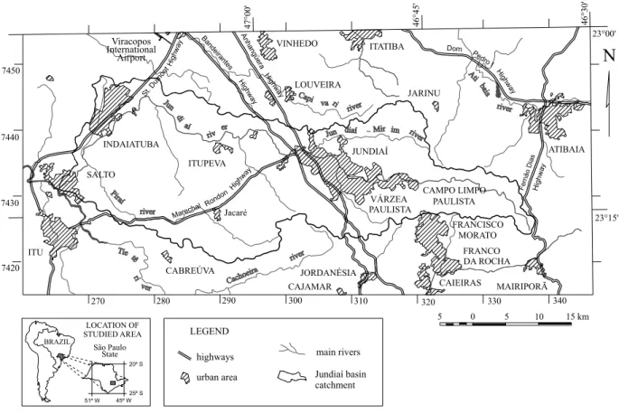
The study area constitutes a rectangular polygon that in-volves all the Jundiaí River Catchment, between 46◦30′
and 47◦20′W Gr. and 23◦00′and 23◦20′ S (Figure 1).
This basin is located less than 100 km from the At-lantic coast, but the mountains of the AtAt-lantic Plateau direct the drainage towards inland. The Jundiaí River begins in theSerra da Mantiqueira(Mantiqueira Moun-tain Range), where the altitudes vary from 1,000 to 1,200 meters above sea level, and ends up in the Tietê River, in altitudes of approximately 550 meters (São Paulo 2000). The area of the basin is about 1,114 km2and its main
trib-utaries are the Jundiaí-Mirim River and the Piraí Stream.
GEOLOGIC ANDHYDROGEOLOGICSETTING
Fig. 1 – Location of the Jundiaí River Catchment, the main highways and urban areas.
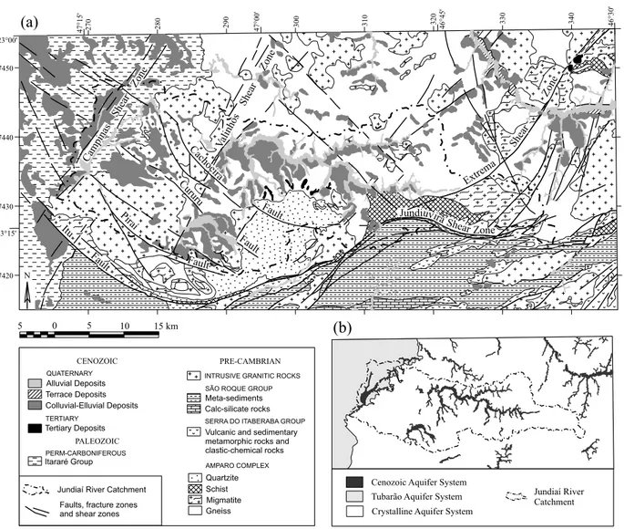
is constituted mainly by phyllites with intercalations of quartzites and calc-silicate rocks, beyond schists, meta-cherts and marbles (Juliani and Beljavskis 1995). Grani-tic intrusions are very common for both units.
The Crystalline Aquifer System is composed of Pre-Cambrian basement units (Figure 2b) and, therefore, its permeability depends on the occurrence of disconti-nuities such as faults and joints and, sometimes, litho-logic contacts (Neves 2005). Over the fractured rock, the weathering layer can form an aquifer of granular poros-ity, responsible by the most part of the catchment base flow (M.F.C. Lopes, unpublished data).
Sedimentary rocks of Paleozoic age belonging to Itararé Group occupy the west side of the area, in the Paraná Sedimentary Basin (Figure 2a), where compose the Tubarão Aquifer System (Figure 2b). The influence of glacial climate in the genesis of these rocks gives heterogeneous characteristics to them, as the vertical and horizontal compositional variability, which induces low permeability and limited potentiality to the aquifer
(Stevaux et al. 1987, Diogo et al. 1984). Even where sandstone layers are considerably thick, there is a great variability of specific capacity of wells due to the layers discontinuity (A.C. Vidal, unpublished data).
Alluvial Quaternary deposits, that occupy the allu-vial plain along the main rivers (Neves et al. 2005a), com-pose the Cenozoic Aquifer System (Figure 2b). Other sedimentary Cenozoic deposits are also present but do not form aquifers due to their restrict occurrence, just covering tops and hill slopes. These are the Tertiary de-posits – that registry an ancient alluvial fan system orig-inated from Japi Mountain Range – and the colluvial-elluvial deposits – spread along the hills (Neves et al. 2005b) (Figure 2a).
STRUCTURAL ANDTECTONICSETTING
Fig. 2 – (a) Geologic map and (b) hydrogeologic map of the Jundiaí River Catchment.
al. 2003). The Jundiuvira Shear Zone (Figure 2a) has NE–SW direction that inflects to E–W, and the Itu, Pi-raí, Cururu and Cachoeira faults have NW–SE direction that also inflects to E–W (Hasui et al. 1978). The Va-linhos and Campinas shear zones (Brasil 1979, S.R.F. Vlach 1985, unpublished data) are also important in this area and cross by the Jundiaí River Catchment following NNE–SSW to NE–SW directions (Neves 2005). The Ex-trema Shear Zone, with the same direction, cut the east side of the area, in the Atibaia region.
Such structures, inherited from the Pre-Cambrian, arose under ductile conditions and developed outstand-ing mylonitic foliation and mineral remobilization. Throughout geologic time, the conditions became more
and more brittle, but the tectonic tensions continued being alleviated along those regional geologic structures. In other words, the Pre-Cambrian structures acted as crustal weakness zones during all the geologic evolution of the area.
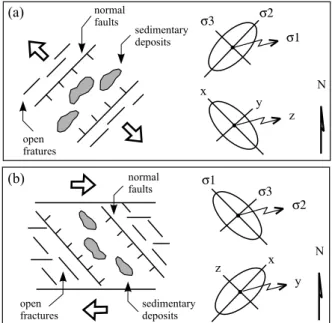
From this evolutionary history it is important to de-fine two main tectonic phases, which understanding is fundamental to this work: the extensional regime that acted in the Gondwana break-up and the transcurrent neotectonic regime that came later.
open joints arise predominantly in NE–SW direction and there is tendency of opening in discontinuities with NE– SW direction inherited from the Pre-Cambrian.
This extensional regime progressively was substi-tuted by a transcurrent regime linked to the rotation of the South-American Plate to the West, process that has been defined as a neotectonic event (e.g. Hasui 1990, Saadi 1993, Riccomini and Assumpção 1999). Some di-vergences exist in the literature about the neotectonic deformational events, but there is an agreement with re-spect to the existence of a transcurrent dextral phase, that would be unique or, at least, very important. Under this regime, a conjugated pair of tensions acts along the E–W direction (Figure 3b) and tends to form open dis-continuities in NW–SE direction and transcurrent dextral faults in E–W direction, between other structures.
Fig. 3 – Regional tectonic movements with the principal structures that arisen out and the tension and deformation ellipsoids of (a) the exten-sional regime, that acted from Upper Cretaceous up to the Paleogene and (b) the dextral transcurrent regime, initiated on Neogene.
VARIATION OF WELL PRODUCTIVITY IN REGIONAL SCALE
Superposition of the lineament and structural maps and the residual maps of specific capacity were done sepa-rately to wells that exploit the Crystalline Aquifer Sys-tem, the Tubarão Aquifer System and both systems. The
positive residuals show places that correspond to more productive wells, that are detached relating to others, i.e., they indicate productivity anomalies.
PRODUCTIVITY ANDLINEAMENTS
In the Crystalline Aquifer System, association between productivity anomalies and lineament density is not ob-servable, neither to that traced in regional scale nor to that traced in more detailed scale (Figure 4). The same occur with the wells that exploit the Tubarão Aquifer System and with the wells that exploit both the aquifers (Figure 5).
In those areas with low lineaments density, the sed-imentary covers generally are present and the weather-ing layer tends to be thicker. Thus, the lineaments be-come disguised and cannot be observed in the remote sensing images. However, where the fracture density is greater, the rocks are easily attacked by weathering and, depending on their original composition, highly perme-able material can be formed. Therefore, one could expect the presence of positive residuals in locations where low lineaments density occur.
PRODUCTIVITY ANDREGIONALSTRUCTURES
The superposition of specific capacity residual maps and the map of faults and shear zones show close associative relations between some productivity anomalies and the structural traces (Figure 6).
The most prominent point with positive residual value occurs close to the Cachoeira Fault. Similarly, there are points of positive anomalies throughout the Valinhos Shear Zone, in its intersection with the Cu-ruru Fault, in the Campinas Shear Zone and next the Itu Fault. Between the faults with NW–SE direction that control the scarps of the Jardim Mountain Range, and throughout there, points with high positive residuals can also be seen.
Fig. 4 – Residual maps of specific capacity of wells that exploit the Crystalline Aquifer System with the lineaments traced from (a) the radar images in 1:250.000 scale and (b) the aerial photography in 1:60.000 scale.
region are due to the morphostructural compartments. Central region is relatively depressed and surrounded by the mountains that delimitate the Jundiaí River Catch-ment and by the structural barrier of Itu granitic massive (Neves et al. 2003).
The positive productivity anomalies of wells that exploit the Tubarão Aquifer System and that exploit both aquifers also have a notable association with the regional structures (Figure 7). The points with high posi-tive residuals are associated to the Campinas Shear Zone, which crosses the area in NNE–SSW direction. Although the Tubarão Aquifer System is a porous aquifer, the structural control also plays an important hole. In-deed, springs were detected along joints that affect sand-stones of the Tubarão Group (Neves 2005).
VARIATION OF WELL PRODUCTIVITY IN LOCAL SCALE
Fig. 5 – Residual maps of specific capacity of wells that exploit (a) the Tubarão Aquifer System and (b) both aquifers, besides the lineaments traced from the radar images in 1:250.000 scale and the aerial photography in 1:60.000 scale.
all of these areas, the presence of lineaments and struc-tures with NW–SE and E–W directions is striking. Three typical examples are presented below.
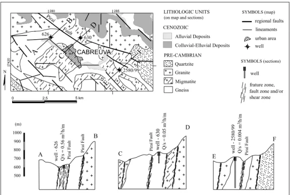
HIGHLYPRODUCTIVEWELLS FROMCABREÚVA
In the Cabreúva region, there are gneisses, migmatites, quartizites and granites of the crystalline basement, as
Fig. 6 – Specific capacity residual map of wells that exploit the Crystalline Aquifer System and its relation with shear zones and regional faults.
Fig. 7 – Residual map of specific capacity of wells that exploit (a) the Tubarão Aquifer System and (b) the wells that exploit both aquifers and the shear zones and regional faults.
zones that intercept the NW–SE and N–S discontinuities in sites where accumulation of alluvial sediments occur. The median specific capacity of wells in this area is equal to 0.08 m3/h/m, greater than the median specific
capacity calculated to the area as a whole by one order of magnitude. To analyze the structural influence in the spatial variation of productivity, the wells number 626,
630 and 2580/99 were selected, the first one with spe-cific capacity equal to 0.56 m3/h/m and the two others
with specific capacity of 0.05 and 0.04 m3/h/m,
2580/99 are located near the same structures, but do not intercept the main structures in depth and, consequently, their productivities are low.
HIGHLYPRODUCTIVEWELLS FROMJACARÉDISTRICT
Another similar case was identified in the Jacaré Dis-trict, near the Marechal Rondon Highway (Figure 9). Two important structures cross this area: the Cururu Fault, with NW–SE direction and high dip to SW, and the Valinhos Shear Zone, with NNE–SSW direction and also high dip to ESE. There are E–W structures, which control Cenozoic deposits occurrences, as well as N–S structures that control the relief dissection giving rise to ravines with the same direction.
In this place, the median specific capacity of wells is equal to 0.05 m3/h/m, minor than the median specific
ca-pacity of wells in the crystalline. But one of the wells has high productivity: the well number 301/48, with specific capacity equal to 1.61 m3/h/m. The other two selected
wells have low productivity: the well number 81, with 0.03 m3/h/m and the well number 44, with 0.04 m3/h/m.
The geological sections (Figure 9) show that, even lo-cated near similar lineaments, the productivity are very different depending on the location relating to the geo-logic structures in subsurface.
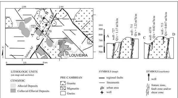
HIGHLYPRODUCTIVEWELLS FROMLOUVEIRA
The third case involves the Louveira County, where gran-ites and gneisses of Amparo Complex, alluvial deposits in the Capivari river alluvial plain and colluvial-elluvial deposits along of its margins coexist (Figure 10). A high number of wells exist in this area, whose median specific capacity is equal to 0.15 m3/h/m, almost two times the
median of the Crystalline System of the whole area. This case stands out by the presence of E–W and NW–SE lin-eaments and, furthermore, a ramification of the Valinhos Shear Zone crossing the area in NNE–SSW direction.
Geological sections were constructed in two loca-tions where four wells in situaloca-tions clearly controlled by structures are present (Figure 10). The wells number 711 and 727 have productivity considered high (specific ca-pacities of 1.22 and 1.17 m3/h/m, respectively) and the
wells number 737 and 6570 demonstrate low productiv-ity (0.17 and 0.02 m3/h/m).
DISCUSSION
Statistic correlations between productivity of wells and their distance to lineaments, length of lineaments, den-sity of lineaments or number of lineament intersections is a common method used to evaluate the chances of finding groundwater in crystalline terrains (e.g. Hard-castle 1995, Loiselle and Evans 1995, Mayer and Sharp 1998). However, some authors emphasize that an in-trinsic subjectivity of lineament tracing does exist (Wise 1982, Tam et al. 2004). Others suggest applying “re-producibility tests” by selecting just the traces that two or more professionals consider as lineaments (Mabee et al. 1994, Sander et al. 1997).
In addition, the structural characterization of the features that are revealed in the lineaments, such as their typology, the dip angle and other particular characteris-tics is of fundamental importance. In the studied area, the simple superposition of maps was capable to show that correlations between positive productivity anoma-lies and the density of lineaments do not exist in both of the applied scales (Figures 4 and 5). The reason for this is that the sedimentary covering and the thick weathering layer can mask the geologic structures of the underlying basement and, consequently, the different lineament den-sities that one observe in the remote sensing imagery do not necessarily reflect the fracturing rate of the geologic substratum. Otherwise, one important characteristics of this area is the conspicuous contrast between landforms with sedimentary cover and pediments beside of others with exposed rocks and rough relief. The first ones tend to show low lineament density and, according to Sing-hal and Gupta (1999), greater capacity for groundwater supplying.
Fig. 8 – The case study of Cabreúva County, where there is control by NW–SE and E–W structures in well productivity.
Fig. 10 – The third case study, in the proximities of Louveira, where wells with high productivity are associated to structural sheaves with NW–SE and E–W directions.
Rudolph (2001), who considered them as opened by neotectonic events.
Gustafsson and Krásn (1994) affirm that inten-sively fractured zones, with dozens kilometers in exten-sion, can form great hydraulic conductors, meanwhile other authors call attention to the fact that not always regional structures are in fact the most productive (e.g. Banks et al. 1992, Nilsen 1998). The discontinuity fill-ing would be an important factor in this case, because the major fractured zones tend to develop clayey filling by the alteration of fragmented material. But the kind of filling depends on the original material and, if the rock is rich in quartz, as granites, gneiss and quartzites, which are abundant in the studied area, the altered ma-terial can be highly permeable (Davis and Turk 1964, Singhal and Gupta 1999, Neves 2005).
Although the existence of fractures is a fundamen-tal factor to defining well productivity in crysfundamen-talline ter-rain, certain characteristics such as their aperture should be favorable to groundwater flow (Lachassagne et al. 2001, Banks et al. 1996, Banks and Robins 2002). The formation of open discontinuities and/or the opening of pre-existent discontinuities occur according to the orien-tation of the major horizontal tectonic tension. In this way, the effects of the extensional tectonic in NE–SW
structures and the transtensional effects of the transcur-rent tectonic in NW–SE structures are of a prime impor-tance to groundwater flow in the fractured rock, mainly if they are associated to others of E–W directions.
However, the fact that one structure is favorable to percolation of water does not indicate that it is related to neotectonic tension action. Older structures can also remain opened through geologic time, especially in in-traplate setting, where tectonic tensions are smaller than in plate borders.
CONCLUSIONS
The morphostructural compartment limits, marked by shear zones and regional faults, are favorable sites to obtain productive wells. Nevertheless, the wells should be located favorably to the structural dip and, further, the structures should be originally opened or submitted to extensional tensions during tectonic reactivations.
Conselho Nacional de Desenvolvimento Científico e Tec-nológico (CNPq). The authors thank Jundsondas Poços Artesianos for the furnishing of well data, Prof. Dr. Yo-citeru Hasui for the initial revision of this paper and the anonymous reviewers of the journal Anais da Academia Brasileira de Ciências for the valorous suggestions.
RESUMO
A produtividade dos poços tubulares profundos em terrenos cristalinos é extremamente variável e depende, além das pro-priedades intrínsecas da rocha, de fatores externos a ela. Na bacia do rio Jundiaí, Região Sudeste do Brasil, a existência de descontinuidades abertas em situações geológicas favoráveis à recarga constitui o principal fator que influencia a produtivi-dade dos poços. Nesta área, zonas de cisalhamento e zonas de falhas pré-cambrianas reativadas ao longo do tempo geológico controlam a compartimentação morfoestrutural e a deposição de sedimentos cenozóicos. O cruzamento do mapa estrutu-ral com os dados dos poços que explotam o Sistema Aqüífero Cristalino mostrou que poços com produtividade elevada em relação aos demais concentram-se ao longo das estruturas re-gionais. O forte controle estrutural sobre a produtividade dos poços também é notável em escala de detalhe. Nesta escala, constatou-se que os poços mais produtivos situam-se em áreas onde estruturas rúpteis de direção NW–SE e E–W denotam a ação de esforços transtrativos neotectônicos. A compreensão da história evolutiva aliada à análise do fraturamento mostrou ser uma técnica eficiente e de baixo custo, conveniente para ser utilizada na seleção de áreas onde, posteriormente, métodos mais dispendiosos poderão ser aplicados.
Palavras-chave:água subterrânea, rochas cristalinas,
tectôni-ca, Jundiaí, Sudeste do Brasil.
BERTACHINIAC. 1988. Análise dos condicionantes estrutu-rais dos aqüíferos fraturados: aplicação à região de Jundiaí (SP). In: CONGRESSO BRASILEIRO DE ÁGUAS SUB -TERRÂNEAS5, São Paulo, SP, Brasil, ABAS, p. 12–21. BRASIL. 1979. Ministério das Minas e Energia.
Departa-mento Nacional de Produção Mineral. Projeto Sapucaí. Brasília: MME/DNPM, 299 p.
BRIZ-KISHOREBH. 1993. Assessment of yield characteris-tics of granitic aquifers in South India. Ground Water 31: 921–928.
CHILTONPJANDFOSTERSSD. 1995. Hydrological charac-terization and water-supply potential of basement aquifers in tropical Africa. Hydrogeol J 3: 36–49.
DAVISJC. 1986. Statistics and Data Analysis in Geology, 2nded., New York: J Wiley & Sons, 646 p.
DAVISSNANDTURKLJ. 1964. Optimum depth of wells in crystalline rocks. Ground Water 22: 6–11.
DIOGOA, BERTACHINI AC, CAMPOSHCNSANDSILVA RBG. 1984. Estudo preliminar das características hidráu-licas e hidroquímicas do Grupo Tubarão no Estado de São Paulo. In: SIMPÓSIOREGIONAL DEGEOLOGIA3, São Paulo, SP, Brasil, SBG, p. 359–364.
FERNANDESAJANDRUDOLPHDL. 2001. The influence of Cenozoic tectonics on the groundwater production capac-ity of fractured zones: a case study in São Paulo, Brazil. Hydrogeol J 9: 151–167.
GUSTAFSSON G ANDKRÁSN J. 1994. Crystalline rock aquifers: their occurrence, use and importance. Appl Hy-drogeol 2: 64–75.
HARDCASTLE KC. 1995. Photolineament factor: a new computer-aided method for remotely sensing the degree to wich bedrock is fractured. Photogramm Eng Rem S 61: 739–747.
-TECTÔNICA E SEDIMENTAÇÃO CONTINENTALCENO -ZÓICA NOSUDESTEBRASILEIRO, Belo Horizonte, MG, Brasil, SBG, p. 1–31.
HASUI Y, TOGNON AA, SOARESL AND CSORDAS SM. 1978. Geologia e tectônica da Serra do Japi. Bol Inst Geoc 9: 17–24.
HASUIY, DANTASASL, CARNEIROCDRANDBISTRICHI CA. 1981. O embasamento pré-cambriano e o Eopa-leozóico em São Paulo. In: ALMEIDA FFM ET AL. (Eds), Mapa Geológico do Estado de São Paulo – escala 1:500.000, São Paulo: IPT, p. 12–45.
HASUI Y, HARALYI NLE, MIOTO JA, SAAD AR, CAM -PANHAVA, HAMZAVM, GALLI VA, FRANGIPANI A AND PULEGHIMI FILHO P. 1989. Compartimentação estrutural e evolução tectônica do Estado de São Paulo. São Paulo, SP, Brasil, IPT, 288 p.
HENRIKSENH. 1995. Relation between topography and well yield in boreholes in crystalline rocks, Sogn og Fjordane, Norway. Ground Water 33: 635–643.
JULIANICANDBELJAVSKISP. 1995. Revisão da litoestrati-grafia da faixa São Roque/Serra do Itaberaba (SP). Rev Inst Geol 16: 33–58.
KNOPMANDSANDHOLLYDAYEF. 1996. Variation in spe-cific capacity in fractured rocks. Ground Water 31: 135– 145.
LACHASSAGNEP, WYNSR, BERARDP, BRUELT, CHERY L, COUTANDT, DESPRATSJ-FANDSTRATPL. 2001. Exploitation of high-yields in hard-rock aquifers: down-scaling methodology combining GIS and multicriteria analysis to delineate field prospecting zones. Ground Water 39: 568–581.
LANDIMPMB. 2003. Análise Estatística de Dados Geoló-gicos. São Paulo: Editora UNESP 2aed., 253 p. LEGRAND HE. 1954. Geology and ground water in the
Statesville area, North Carolina. Miner Resour Bull 68: 68–73.
LIUCC. 1987. A Geologia Estrutural do Rio de Janeiro vis-ta através de imagens MSS do Landsat. In: SIMPÓSIO DEGEOLOGIAREGIONAL1, Rio de Janeiro, RJ, Brasil, SBG, p. 164–188.
LOISELLEMANDEVANSD. 1995. Fracture density distri-butions and well yields in coastal Maine. Ground Water 33: 190–196.
MABEE SB, HARDCASTLE KC AND WISE DU. 1994. A method of collecting and analyzing lineaments for regional-scale fractured-bedrock aquifer studies. Ground Water 32: 884–894.
MACERE. 1997. Determination of transmissivity from spe-cific capacity tests in a karst aquifer. Ground Water 35: 738–745.
MAYERJRANDSHARPJM. 1998. Fracture control of re-gional ground-water flow in a carbonate aquifer in a semi-arid region. Geol Soc Amer Bull 110: 269–283. NEVESMA. 2005. Análise do Fraturamento do Maciço
Ro-choso Aplicada à Exploração de Águas Subterrâneas na Bacia do Rio Jundiaí (SP). PhD. Universidade Estadual Paulista, Rio Claro, SP, Brasil.
http://www.biblioteca.unesp.br/bibliotecadigital. NEVESMA, MORALESN, BORGESMSANDEBERTHD.
2003. Compartimentação morfotectônica da região de Jundiaí (SP). Rev Bras Geocienc 33: 167–176.
NEVESMA, MORALESNANDSAADAR. 2005a. Cober-turas sedimentares cenozóicas da bacia do rio Jundiaí (SP). Geociências 24: 289–303.
NEVESMA, MORALESNANDSAADAR. 2005b. Facies analysis of Tertiary alluvial fan deposits in the Jundiaí region, São Paulo, southeastern Brazil. J South Am Earth Sci 19: 509–520.
NILSEN B. 1998. Norwegian sub-sea tunnels – a review with emphasis on water leakages. In: INTERNATIONAL CONGRESS ONTUNNELS ANDWATER, Rotterdam, The Netherlands, IAHS, p. 913–918.
O’LEARYDW, FRIEDMANJDANDPOHNHA. 1976. Lin-eament, linear, lineation: some proposed new standards for old terms. Geol Soc Amer Bull 87: 1463–1469. RICCOMINICANDASSUMPÇÃOM. 1999. Quaternary
tec-tonics in Brazil. Episodes 22: 221–225.
SAADIA. 1993. Neotectônica da plataforma brasileira: es-boço e interpretação preliminar. Geonomos 1: 1–15. SANDERP, MINORTBANDCHESLEYMM. 1997.
Ground-water exploration based on lineament analysis and repro-ducibility tests. Ground Water 30: 888–894.
SÃOPAULO (ESTADO). 2000. Conselho Estadual de Re-cursos Hídricos. Comitê das bacias hidrográficas dos rios Piracicaba, Capivai e Jundiaí. Relatório de situação dos recursos hídricos das Bbcias dos rios Piracicaba, Capivari e Jundiaí: Relatório Zero. Piracicaba, SP, Brasil, 1CD. SIDDIQUISHANDPARIZEKRR. 1971. Hydrogeologic
fac-tors influencing well yields in folded and faulted carbon-ate rocks in Central Pennsylvania. Wcarbon-ater Resour Res 7: 1295–1312.