Article
Landscape Builder: Software for the creation of initial landscapes for
LANDIS from FIA data
William Dijak
USDA Forest Service, Northern Research Station, 202 Anheuser-Busch Natural Resources Building, Columbia, MO 65211,USA E-mail: [email protected]
Received 8 February 2013; Accepted 10 March 2013; Published online 1 June 2013
Abstract
I developed Landscape Builder to create spatially explicit landscapes as starting conditions for LANDIS Pro
7.0 and LANDIS II landscape forest simulation models from classified satellite imagery and Forest Inventory and Analysis (FIA) data collected over multiple years. LANDIS Pro and LANDIS II models project future landscapes by simulating tree growth, tree species succession, disease, insects, fire, wind, and management
disturbance. Landscape Builder uses inventory plot attributes from the FIA inventory database, FIA unit map, National Forest type map, National Forest size class map, land cover map, and landform map to assign FIA
plot attributes to raster pixels representing a real forest landscape. In addition to creating a detailed map of current (initial) forest landscape conditions, the software produces specific files required for use in LANDIS Pro 7.0 or LANDIS II format. Other tools include the ability to create a dominant species and age-class map
from previously created LANDIS maps, a tool to create a dominant species and age-class map from a stand map and field plot data, and a tool to convert between Esri ascii rasters and Erdas file format types.
Keywords Landscape Builder; forest inventory and analysis; LANDIS Pro; LANDIS II; Landscape HSImodels.
1 Introduction
Forest landscape models (FLMs) forecast changes in tree species composition, stand structure, and tree
age/size class at landscape scales based on tree species establishment, growth, competitive interactions, and disturbance from wind, fire, insects, and tree harvest (Shifley et al., 2006; Gustafson et al., 2010; Rittenhouse
et al., 2010; Zhang, 2012) and climate change (Gustafson et al., 2010; Scheller and Mladenoff, 2008). LANDIS (Mladenoff and He 1999; He et al., 2002) and LANDIS II (Scheller et al., 2007) are FLMs that have
been used over 40 countries and regions (Mladenoff, 2004). In a FLM, the forest landscape is divided into raster cells (polygons for some models); Site-level processes such as forest succession and competition are simulated in each cell, and forest landscape processes (e.g., seed dispersal, disturbance, and harvest) are
simulated over a subset of spatially continuous cells. However, it is difficult and time consuming to populate
Computational Ecology and Software ISSN 2220721X
URL: http://www.iaees.org/publications/journals/ces/onlineversion.asp RSS: http://www.iaees.org/publications/journals/ces/rss.xml
Email: [email protected] EditorinChief: WenJun Zhang
each cell that is spatially representative of real landscapes (Ballestores and Qiu, 2012) and that have realistically complex tree species and age composition. On the other hand, FLMs have not fully taken
advantage of the available extensive forest inventory data to initialize and constraint model parameters. Currently, many FLMs usually utilize tree species occurrence and frequency imputed across the landscape (e.g., Zhang et al., 2009; Thompson et al., 2011). This is because model input parameters such as
absence/presence, biomass and ANPP are not comparatively straightforward to inventory data, which usually directly involves tree number and stem diameter (Pacala et al., 1996; Moorcroft et al., 2001). Meanwhile, in
U.S. Forest Inventory and Analysis (FIA) dataset, millions of individual tree and stand records are available (Woodall et al., 2010), which provide opportunity for FLMs to be directly initialized from, and calibrated against the available inventory data to constrain model parameters and initial forest condition. Hence, in this
paper, I describe Landscape Builder software that simplifies the process of creating spatially realistic digital landscapes based on the best available forest inventory data and digital map layers. The software also includes
additional tools for creation of dominant species and age maps as well as file format conversion (http://www.fs.fed.us/nrs/software/landscapebuilder/).
Output from landscape forest simulation models and Landscape Builder can also be used by wildlife
habitat suitability models such as Landscape HSImodels (Dijak et al., 2007; Dijak and Rittenhouse, 2009; Rittenhouse et al., 2007; Larson et al., 2003) to assess current and future changes to forest wildlife habitat
suitability. Landscape Builder software creates spatially representative digital forest landscapes using Forest Inventory and Analysis data (FIA data) (Miles et al., 2001), a FIA unit map, a landform map, a land cover map,
and optionally a forest type and age class map developed from forest stand maps. The landform map can be created from a digital elevation model (DEM) using tools developed by Jenness (2011). Land cover maps created from classified satellite imagery such as state GAP Analysis Program maps or National Land Cover
Data maps (NLCD) can be used to define basic forest cover types. However, greater spatial detail on forest conditions can be derived from optional forest species and age class maps created directly from U.S. Forest
Service (USFS) stand inventory data for National Forests or for compatible stand inventory data from other ownerships where the map information can be reclassified to match Forest Service coding. Currently the software supports creation of maps for all states for which FIA inventory data exists and for National Forest
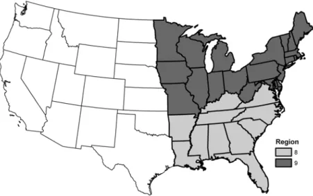
lands within U.S. Forest Service Regions 8 and 9 (Fig. 1) which collectively encompass the eastern half of the United States. In addition to the LANDIS Species Map Creator (LSMC) tool (see below), there is a tool to
create a dominant tree species map from maps created with the LSMC tool, a tool to create a dominant tree species map and an age class map from a stand map and vegetation plot inventory data and a tool that performs batch file conversions to and from Esri ascii rasters and Erdas 7.4 file formats. Landscape Builder is
programed in Visual Basic, Ansi C and Windows API and runs on Windows XP and Windows 7 operating systems with landscapes 7500 × 6500 pixels in size.
2 LANDIS Species Map Creator
A key process in developing an initial digital landscape for use with LANDIS is assigning appropriate tree
species and sizes (or ages) to each pixel on the initial landscape map. The LSMC tool within the Landscape Builder software can be used with FIA inventory data to create spatially representative maps of tree species
and age classes and to create auxiliary species attribute files used by LANDIS Pro 7.0 and LANDIS II. LSMC classifies regional FIA inventory data by inventory year, FIA geographic unit code, county code, plot number, subplot number, tree status code, tree species code, tree species group code, tree diameter, stand age and tree
assign FIA representative plots to raster pixels representing the landscape.
Fig. 1 Landscape Builder software is currently operable in the entire United States and for U.S. Forest Service lands in regions 8 and 9.
Prior to using the LSMC tool, the user must identify the tree species (or species group) of interest, which
are typically the dominant species in the area and can be identified evaluating the frequency of occurrence or basal area of species in the corresponding FIA database. The user also needs to determine the maximum longevity in years for each tree species or species group for the area of interest in order to produce the attribute
files described in the species map. Longevity can be estimated from silvics guides or from local knowledge about the species. Also the user must identify whether each species will typically sprout if top-killed. The
user assigns a species code whose order matches the order in the species attribute file in the LANDIS model. The assigned species codes are typically used to group species that have similar ecological niches and to separate individual species of interest. The information required by to run LSMC is organized and entered
using an electronic form (Fig. 2).
The final piece of information required (right-most column in Fig. 2) is an equation to convert tree
diameters from the FIA inventory to estimated tree ages required for LANDIS. This can be accomplished using published diameter-age equations (e.g., Lowenstein et al., 2000) or other data sources (e.g., FIA site-index data) to create diameter-age regression equations for each species group.
When processing the data, LSMC follows methods described in detail by Dijak and Rittenhouse (2009) and Zhang et al. (2009). Briefly, FIA inventory data are first stratified by FIA geographic unit, landform, forest
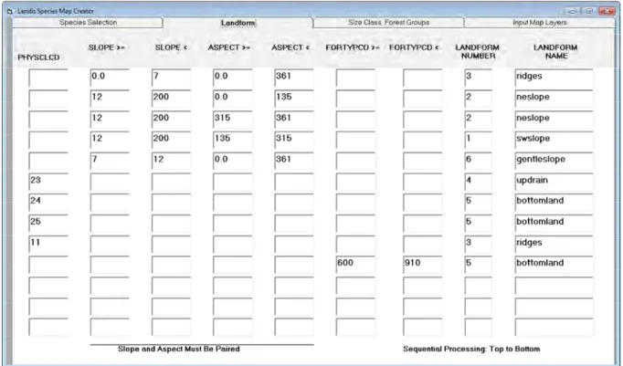
type and size class. Landform for FIA data is determined from a plot’s physiographic class code, slope, aspect, and/or forest type code. User-defined rules for assigning landforms are entered using the Landform interface of
the Landscape Builder software (Fig. 3). The inventory years and time step being modeled are also specified by the user in the Size class, Forest Groups data form of Landscape Builder (Fig. 4). This form also requires users to assign rules for clustering FIA plot ages into stand size classes and matching FIA plot forest types to
the basic land cover types from the land cover map. A forest patch map is created internally by combining landform and land cover maps and using the intersection of landform and land cover to identify unique forest
patches. Each patch is then assigned an appropriate forest type and size class based on a random draw from pool of FIA plots assigned to that landform and cover type (Fig.3). Patch assignments are therefore proportional to the forest types and size classes found within the FIA database. Next the FIA plots are stratified
landform, forest type and size class. Each plot is assigned a unique sequential number which is stored in the species map attribute file. Tree species and age information for the corresponding plot is also stored in the
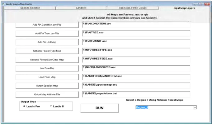
species map attribute file. All input and output files are specified on the Input Map Layers form(Fig.5). For LANDIS Pro 7.0 the data are stored as the number of trees of each age class by species. The number of trees is calculated for each pixel based on the map cell size and the FIA tree expansion factor. For maps with
resolution of 10 m or less, subplots (0.017 ha) can be used to populate the pixels since FIA subplot size more closely approximates 10 m cell resolution. For LANDIS II the ages for each tree species by age cohort are
reported in the map attribute file. FIA data contain information from multiple inventory years and the user is allowed to select which inventory years to use. Since 1999, inventories have been conducted on a 5 year cycle so it is inadvisable to use more than 5 inventory years per map creation. Resulting landscapes are spatially
representative but not spatially exact.
For U.S. National Forest lands for which forest type stand maps and size class maps can be created, FIA
plots matching forest type and size class are assigned to each mapped stand; this results in greater spatial fidelity of the digital landscape to the observed spatial arrangement of forest type and age class on the ground. Currently, this feature of the software is supported for National Forest lands found in the eastern half of the
United States (U.S. Forest Service regions 8 & 9). Future regions will be added in later versions.
Fig. 3 LANDIS Species Map Creator form 2 interface. User creates rules to assign FIA plots to specific landforms using FIA plot physiographic class code, slope, aspect and forest type.
Fig. 5 LANDIS Species Map Creator form 4 interface. User specifies input and output files, output format for map attribute files and the U.S. Forest Service region that the landscape falls within.
3 Dominant Species and Age Maps
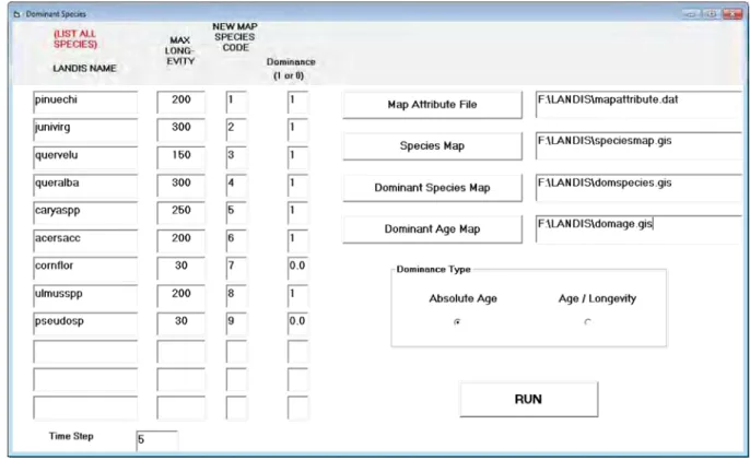
The dominant species and age map tool allows the user to map dominant species and age class by pixel from
the trees assigned to each pixel. The age class can be based on either the absolute tree age (oldest tree on a pixel) or the relative tree age (tree age relative to the maximum longevity for its species). Species that rarely dominate forests (e.g., species that are typically confined to the understory) can be excluded from the mapping
process. The mapping process reads the files output by the LSMC tool and creates separate maps for dominant tree species and age class of dominant species. Maps of dominant tree species and age classes are useful for
describing LANDIS starting conditions or for other purposes such as habitat suitability models such as Landscape HSImodels (Dijak et al., 2007; Dijak and Rittenhouse, 2009; Rittenhouse et al., 2007; Larson et al., 2003).
4 Inventory Plot Dominant Species Maps
The tool is used to create a dominant species and an age class map from a forest stand map and a tree species stocking file (Fig. 7) and outputs a species map and age class map. The input stand map can be created from field inventory information and the stocking file information can come from field plot measurements within
those stands. The stocking file can be created in a spread sheet and exported as a space delimited text file with all non-numeric text removed. The stocking file is a table consisting of dominant tree species, age classes of
Fig. 6 Dominant Species Map Creator interface. User specifies information used to create the original LANDIS map, determines which species should be considered for dominance, input and output files and method of determining dominance.
Fig. 7 Stocking file for the creation of dominant species and age class maps from field plot inventories. Labels added for clarity but must be removed before processing.
5 Batch File Conversion
The batch file conversion tool converts files to and from Esri ASCII file format and Erdas 7.4 file format and
6 Conclusions
Landscape Builder uses land cover to maintain the fidelity of spatial location of forest, uses land form to
reflect spatial heterogeneity of forest composition and structure, and uses age-size relationship and randomness (reflecting local variations) to assign information from an individual FIA plot to a pixel. It improves the efficiency of LANDIS model initialization and ensures that the initialized landscape accurately reflect the
patterns and variations in FIA. Resulting landscapes are spatially representative but not spatially exact, and can be used in regional forest assessment and as input for forest landscape modeling. Output from FLMs and
Landscape Builder can also be used by wildlife habitat suitability models such as Landscape HSImodels (Dijak et al., 2007; Dijak and Rittenhouse, 2009; Rittenhouse et al., 2007; Larson et al., 2003) to assess current and future changes to forest wildlife habitat suitability.
Acknowledgements
I thank Stephen Shifley, Hong He, Wen Juan Wang, Jacob Frasier and Frank Thompson for their help and suggestions in the development of this software and manuscript. The USDA Forest Service, Northern Research Station funded this project.
References
Ballestores F Jr, Qiu ZY. 2012. An integrated parcel-based land use change model using cellular automata and decision tree. Proceedings of the International Academy of Ecology and Environmental Sciences, 2(2):
53-69
Dijak WD, Rittenhouse CD. 2009. Development and application of habitat suitability models to large
landscapes. In: Models for Planning Wildlife Conservation in Large Landscapes (Millspaugh JJ, Thompson FR III, eds). 367-389, Elsevier Science, San Diego, California, USA
Dijak WD, Rittenhouse CD, Larson MA, et al. 2007. Landscape habitat suitability index software. Journal of
Wildlife Management, 71: 668-670
Gustafson EJ, Shvidenko AD, Sturtevant B, et al. 2010. Predicting global change effects on forest biomass and
composition in south-central Siberia. Ecological Applications, 20: 700-715
He HS, Larsen DR, Mladenoff DJ. 2002. Exploring component based approaches in forest landscape modeling.
Environmental Modelling and Software, 17: 519-529
Jenness J, Brost B, Beier P. 2011. Land Facet Corridor Designer: Extension for ArcGIS. Jenness Enterprises. http://www.jennessent.com/arcgis/land facets.htm
Lowenstein EF, Johnson PJ, Garret HE. 2000. Age and Diameter structure of a managed Uneven-aged oak forest. Can. Journal of Forest Research, 30: 1060-1070
Larson MA, Dijak WD, Thompson FR III, et al. 2003. Landscape-level Habitat Suitability Models for Twelve Species in Southern Missouri. General Technical Report NC-233. U.S. Department of Agriculture, Forest Service, North Central Research Station, St. Paul, MN, USA
Miles PD, Brand GJ, Alerich CL, et al. 2001. The Forest Inventory and Analysis Database Description and User’s Manual Version 1.0. General Technical Report NC-218. U.S. Department of Agriculture, Forest
Service, North Central Research Station, St. Paul, MN, USA
Mladenoff DJ, He HS. 1999. Design and behavior of LANDIS, an object-oriented model of forest landscape disturbance and succession. In: Advances in Spatial Modeling of Forest Landscape Change: Approaches
demography model (ED). Ecological Monographs, 71: 557-585
Pacala SW, Canham CD, Silander JAJ, et al. 1996. Forest models defined by field measurements: Estimation,
error analysis and dynamics. Ecological Monographs, 66: 1-43
Rittenhouse CD, Dijak WD, Thompson FR III, et al. 2007. Development of Landscape-level Habitat Suitability Models for Ten Wildlife Species in the Central Hardwoods Region. General Technical Report
NRS-4. U.S. Department of Agriculture, Forest Service, Northern Research Station, Newtown Square, PA, USA
Rittenhouse CD, Thompson FR III, Dijak WD, et al. 2010. Evaluation of habitat suitability models for forest passerines using demographic data. Journal of Wildlife Management, 74: 411-422
Rittenhouse CD, Shifley SR, Dijak WD, et al. 2011. Application of landscape and habitat suitability models to
conservation: the Hoosier National Forest land-management plan. In: Landscape Ecology in Forest Management and Conservation. Challenges and solutions for global change (Li C, Lafortezza, Chen J, eds).
299-328, Higher Education Pres, Beijing and Springer-Verlag, Berlin Heidelberg, Beijing, China
Scheller RM, Mladenoff DJ. 2008. Simulated effects of climate change, fragmentation, and inter-specific competition on tree species migration in northern Wisconsin, USA. Climate Research, 36: 191-202
Shifley SR, Thompson FR III, Dijak WD, et al. 2006. Simulated effects of forest management alternatives on landscape structure and habitat suitability in the Midwestern United States. Forest Ecology and
Management, 229: 361-377
Woodall CW, Heath LS, Domke G, et al. 2011 Methods and Equations for Estimating Volume, Biomass, and
Carbon for Trees in the U.S. Forest Inventory, 2010. General Technical Report NRS-GTR-88. U.S. Department of Agriculture, Forest Service, Northern Research Station, Newtown Square, PA, USA
Zhang WJ. 2012. Computational Ecology: Graphs, Networks and Agent-based Modeling. World Scientific,
Singapore
Zhang Y, He HS, Dijak WD, et al. 2009. Integration of satellite imagery and forest inventory in mapping