www.ocean-sci.net/10/759/2014/ doi:10.5194/os-10-759-2014
© Author(s) 2014. CC Attribution 3.0 License.
Variability of water mass properties in the Strait of Sicily
in summer period of 1998–2013
A. Bonanno1, F. Placenti1, G. Basilone1, R. Mifsud2, S. Genovese1, B. Patti1, M. Di Bitetto3, S. Aronica1, M. Barra1, G. Giacalone1, R. Ferreri1, I. Fontana1, G. Buscaino1, G. Tranchida1, E. Quinci1, and S. Mazzola1
1Istituto per l’Ambiente Marino Costiero (IAMC) of the Consiglio Nazionale delle Ricerche (CNR), Detached Units of
Capo Granitola (TP), Naples and Mazara del Vallo (TP), Italy
2Ministry for Resources and Rural Affairs (MRRA), Fort San Lucjan, Malta 3Consiglio Nazionale delle Ricerche (CNR), P.le A. Moro, 7-00185, Rome, Italy
Correspondence to: F. Placenti ([email protected])
Received: 27 January 2014 – Published in Ocean Sci. Discuss.: 13 March 2014 Revised: 14 August 2014 – Accepted: 29 August 2014 – Published: 2 October 2014
Abstract. The Strait of Sicily plays a crucial role in deter-mining the water-mass exchanges and related properties be-tween the western and eastern Mediterranean. Hydrographic measurements carried out from 1998 to 2013 allowed the identification of the main water masses present in the Strait of Sicily: a surface layer composed of Atlantic water (AW) flowing eastward, intermediate and deep layers mainly com-posed of Levantine intermediate water (LIW), and transi-tional eastern Mediterranean deep water (tEMDW) flowing in the opposite direction. Furthermore, for the first time, the signature of intermittent presence of western intermediate water (WIW) is also highlighted in the northwestern part of the study area (12.235◦E, 37.705◦N).
The excellent area coverage allowed to highlight the high horizontal and vertical inter-annual variability affecting the study area and also to recognize the permanent character of the main mesoscale phenomena present in the surface water layer.
Moreover, strong temperature-salinity correlations in the intermediate layer, for specific time intervals, seem to be linked to the reversal of surface circulation in the central Io-nian Sea.
The analysis of CTD data in deeper water layer indicates the presence of a large volume of tEMDW in the Strait of Sicily during the summers of 2006 and 2009.
1 Introduction
saltier Levantine intermediate water (LIW), enriched by Cre-tan intermediate water (CIW). Two quasi-closed secondary cells are present in the eastern and in the western Mediter-ranean Basins, which are responsible for the transformation of surface and intermediate waters into eastern and western Mediterranean deep waters (EMDW and WMDW), respec-tively. The role of the LIW is particularly important since it is the preconditioning agent for the formation of both the Adri-atic deep water (AdDW) and WMDW (Gaˇci´c et al., 2013). At sub-basin level (iii), two main veins of the AW are known to flow in the Strait of Sicily: the Atlantic Tunisian Current (ATC) (Sammari et al., 1999) in the south along the African coast, and the Atlantic Ionian Stream (AIS) (Robinson et al., 1999) in the north along the Sicilian coast. The AIS consti-tutes an energetic current mainly flowing eastward, able to force upwelling on the Adventure Bank (AB) (Fig. 1) and along the southern Sicilian coast, especially during summer, when such current is stronger. An important spatial variabil-ity exists in terms of shape, position and strength of perma-nent or quasi-permaperma-nent sub-basin gyres and their unstable lobes, meanders patterns, bifurcation structures and strength of permanent jets, transient eddies and filaments (Robinson et al.,1999; Sorgente et al., 2011; Basilone et al., 2013; Bo-nanno et al., 2013). The ATC, flowing along the Tunisian coast, shows a more clearly-marked path in winter (Sorgente et al., 2003, 2011; Béranger et al., 2004) than in summer. Further confirmation of the weakening of the ATC signal in summer is highlighted by Placenti et al. (2013), who found a more regular jet of the AIS than the ATC, which becomes un-stable, also producing small-scale features (Gasparini et al., 2008). The intermediate and deep circulations in the Strait of Sicily are mainly represented by the intermediate water of eastern origin, moving westwards around the submarine mountains of the eastern Mediterranean before crossing the channel through the sills, south of Malta, at a depth rang-ing from 250 to 350 m (Placenti et al., 2013; Lermusiaux and Robinson, 2001). Interannual changes have been recorded in the outflowing dense-water-mass characteristics in the Sicily Channel (Gasparini et al., 2005).
The classical view of a quasi-stable thermohaline circula-tion of the Mediterranean has recently been overruled. Dur-ing the 1990s, deep water formed in the Aegean Sea re-placed that formed in the Adriatic. Huge amounts of dense waters characterized by enhanced salinity and temperature were released for a few years, forming the eastern Mediter-ranean Transient (EMT) (Roether et al., 2007; Theocharis et al., 2002), significantly influencing the thermohaline struc-ture and stratification of the entire eastern Basin (Borzelli et al., 2009; Gaˇci´c et al., 2013). The EMT-induced changes have been communicated through the Strait of Sicily to the western Mediterranean Basin (Gasparini et al., 2005). A sig-nificant warming and salinification of the whole water col-umn has also been observed in the western Mediterranean, comparable to the EMT, both in terms of intensity and ob-served effects (Schroeder et al., 2008). Furthermore, it has
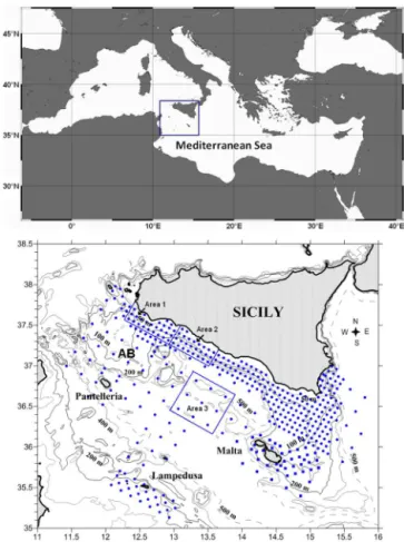
Figure 1. The study area in the Strait of Sicily and the overall sam-pling design adopted in the period 1998–2013 (blue dots); the Mal-tese waters are investigated since 2004 (blue squares). Upwelling areas (1 and 2) and the control area (3) are identified by three rect-angles.
been demonstrated that the upper-layer circulation in the Io-nian (Borzelli et al., 2009; Gaˇci´c et al., 2010), the thermo-haline properties of the AdDW (Gaˇci´c et al., 2010) and the salt distribution over the EM (Gaˇci´c et al., 2011) are inter-connected through the Bimodal Oscillating System (BiOS) (Gaˇci´c et al., 2010). In fact, during the last 25 years, it has been observed that the upper-layer circulation in the Ionian reversed on decadal time scales, from anticyclonic to cy-clonic, and vice versa. In particular, the anticyclonic mode represents a preconditioning mechanism for the dense-water-formation processes in the Aegean and eventually for EMT-like events (Demirov and Pinardi, 2002; Gaˇci´c et al., 2011). In this context, the Strait of Sicily is the most suitable re-gion for observing the exchanges between the two basins and, more specifically, for following how hydrographic mod-ifications produced in one sub-basin can propagate into the other one (Gasparini et al., 2005).
the permanent character of the main mesoscale circulation structures in the area. The entire time series is analysed both in terms of horizontal and vertical spatial variability, and may improve the understanding of long-term variability and evo-lution of the Mediterranean circulation. The document also provides contributions that may allow the modellers to as-sess the performance of hydrological models of this area.
2 Data set and methods
The data set analysed here has been acquired over 16 oceano-graphic surveys carried out during the period 1998–2013 (Table 1) on board the R/V Urania in the Strait of Sicily. Sampling stations are arranged on a regular grid of 4 nau-tical miles in inshore waters and 12 miles in offshore wa-ters, to ensure maximum area coverage with specific atten-tion to the continental shelf along the southern coast of Sicily (Fig. 1). Since 2004, CTD profiles have also been collected in the Maltese waters in the framework of the FAO Med-SudMed Project “Assessment and monitoring of the fish-ery resources and the ecosystems in the Straits of Sicily” (http://www.faomedsudmed.org/). The sampling design in Fig. 1 shows the maximum area coverage in the Strait of Sicily; during some of the surveys, such design was modi-fied, mainly due to bad weather conditions. The long-term variability in the hydrological characteristics of the Strait of Sicily has been analysed on the basis of vertical profiles of temperature (◦C) and salinity obtained from the surface to the
bottom by means of a CTD-rosette system. This consisted of a CTD SBE 911 plus probe and a General Oceanics rosette, equipped with 24 12 L Niskin Bottles. The probes were cal-ibrated before and after the cruise at CMRE (NATO Centre for Maritime Research and Experimentation) in La Spezia, Italy. The collected downcast data were quality-checked and processed in agreement with the Mediterranean and ocean database instructions (Brankart, 1994), using the Seasoft-Win32 software. The overall accuracies are within 0.001◦C
for temperature, 0.001 s m−1 for conductivity, and 0.015 %
of full scale for pressure. With the aim of characterizing wa-ter masses and their inwa-ter-annual variability, we divided the water column into three layers. Two of them – the surface (0–200 m) and the intermediate (200–500 m) layers – repre-sent the two main water masses in the Strait of Sicily; a third layer (> 500 m) is considered for characterizing deeper water mass. Mean values of temperature, salinity and density (and SD in Table 2) are evaluated for the area with longitude in the range 11.5–15◦E and latitude in the range 35–38◦N. In
the same area, mean values of salinity minimum (Smin)and
salinity maximum (Smax), as well as mean potential
temper-ature and mean depth at the salinity minimum and salinity maximum, are estimated.
Three specific sub-areas have been identified in the study area to highlight the effects of coastal upwelling on the tem-perature and salinity fields, and to verify the persistence of
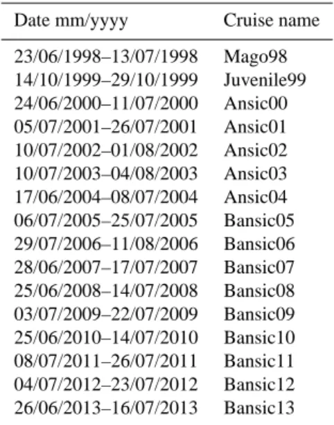
Table 1. Sampling period and name of the oceanographic surveys carried out in the Strait of Sicily.
Date mm/yyyy Cruise name
23/06/1998–13/07/1998 Mago98 14/10/1999–29/10/1999 Juvenile99 24/06/2000–11/07/2000 Ansic00 05/07/2001–26/07/2001 Ansic01 10/07/2002–01/08/2002 Ansic02 10/07/2003–04/08/2003 Ansic03 17/06/2004–08/07/2004 Ansic04 06/07/2005–25/07/2005 Bansic05 29/07/2006–11/08/2006 Bansic06 28/06/2007–17/07/2007 Bansic07 25/06/2008–14/07/2008 Bansic08 03/07/2009–22/07/2009 Bansic09 25/06/2010–14/07/2010 Bansic10 08/07/2011–26/07/2011 Bansic11 04/07/2012–23/07/2012 Bansic12 26/06/2013–16/07/2013 Bansic13
this phenomenon. In particular, areas 1 and 2 in Fig. 1 are those in which the phenomenon typically occurs, while area 3 has been considered as a control area on which the coastal upwelling has no effect. In each area, mean temperature and salinity in the upper layer (5–30 m) are estimated.
The main surface circulation features in the Strait of Sicily were evaluated by means of the altimeter products (abso-lute dynamic topography) produced by Ssalto/Duacs and dis-tributed by Aviso, with support from Cnes (http://www.aviso. oceanobs.com/duacs/). The estimated path of the two main streams (AIS and ATC) of the AW was checked by us-ing salinity profiles collected in the study area. Since both streams are mainly characterized by a salinity minimum (Smin), for each oceanographic survey, the cores of AIS and
ATC were also identified bySminvalues at each transect
per-pendicular to the Sicily coast (e.g. Fig. 5). The circulation pattern (geostrophic velocity field) in the study area was eval-uated in the periods of the oceanographic surveys (see Ta-ble 1).
3 Results
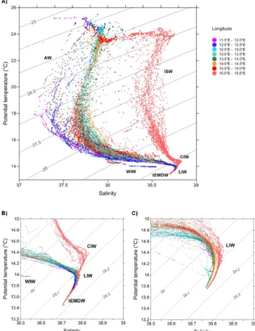
The θ-S diagram (e.g. Fig. 2 for the 1999 survey) mainly highlights the presence of two highly stratified water masses: fresher AW in the upper layer, and an intermediate westward-flowing salty LIW. A third layer of transitional water masses (tEMDW) with variable hydrological characteristics is also evident. The Ionian surface water (ISW) is recorded only in some stations located east of meridian 15◦E, while, in the
3.1 The surface layer
The analysis of the data set, mainly constituted by CTD pro-files acquired in the period between the end of June and July (except in 1999; see Table 1), confirms a high variability of the surface layer (0–200 m) in terms of temperature, salinity and density (Table 2), due to the complex circulation of sur-face water. The presence of a water mass of Atlantic origin is highlighted by the minimum in the vertical salinity pro-files (Smin). The average value of salinity minimum varied
between 37.22, observed during the survey “Bansic07”, and 37.86, recorded in the survey “Bansic12” (Fig. 3a). Poten-tial temperature at a depth of minimum salinity varied be-tween 17.36 and 20.34◦C, which were the mean values
es-timated during the oceanographic surveys “Bansic13” and “Bansic08”, respectively (Fig. 3b).
The analysis of the hydrological data set evidences the presence of transition water positioned between AW and LIW: the WIW (Fig. 2). During the surveys in the Strait of Sicily, this has been recognized with a clear signal in some stations in the northwestern part of the study area during the 1999, 2005, 2006, 2009, 2010 and 2013 surveys. Here, the WIW is characterized by a potential temperature between 13.95 and 14.2◦C, a salinity in the range 38–38.6 and
den-sity lower than 28.8 kg m−3; it forms a portion of the water
column positioned between a 100 and 200 m depth.
Mean values of Smin and TSmin show large inter-annual
variability (Fig. 3). From 1998 to 2007, mean values ofSmin
were characterized by moderate variability around 37.4. In the period 2007–2012, a positive trend was evident up to a mean value of about 37.7. The trend, reported in Fig. 3, slightly changes if data from the western Ionian Sea (longi-tudes 15–15.5◦E) is included.
Smin values are significantly correlated (r=0.72,
p< 0.05) with mean salinity values estimated in the upper layer (0–200 m) of the water column (Table 2), while there is no correlation betweenTSminand mean temperature in the
same upper layer. This latter result is likely due to the effects of coastal upwelling, strongly influencing the temperature field along the coast of southern Sicily (Table 3).
A Kruskal–Wallis (K–W) ANOVA test (Conover, 1999) was carried out to verify whether significant differences ex-ist among the three areas evidenced in Fig. 1, and to high-light the effects of upwelling events in the analysed pe-riod. K–W ANOVA results showed that significant differ-ences exist among identified areas in terms of both salinity (H(2,N=48)=14.52;p< 0.05) and temperature (H(2,N=48)=
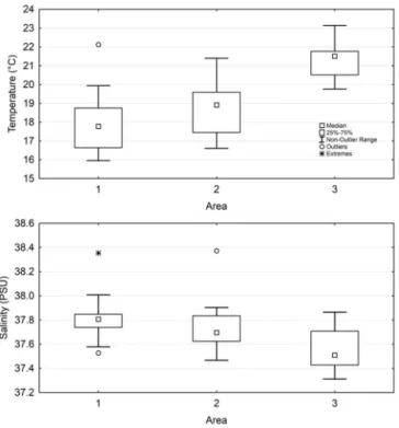
27.23; p< 0.05). Specifically, post-hoc test highlights that area 1 and area 2 are not significantly different, while area 3 is characterized by significantly higher temperature and lower salinity values (Fig. 4) than area 1 and area 2. Fur-thermore, temperature values related to area 3 show lower variability than in area 1 and area 2, while in terms of salinity area 1 and area 2 are characterized by lower variability than area 3. Such a different variability in terms of salinity and
Figure 2. (a)θ-Sdiagram for the survey Juvenile99 (Strait of Sicily and west Ionian Sea). The colors refer to longitude of the stations. θ-Sdiagrams in the salinity range 38.5–39 for the survey Juvenile99 (b) and Ansic04 (c).
temperature could reflect the variability of the AIS path in the area 3. The outlier value identified for temperature in area 1 is related to the year 1999, when the survey was carried out during Autumn (Fig. 4). During summer 2012 the observed anomalous salinity values in area 1 and area 2 are linked to the strong upwelling event affecting the whole coastal area along the southern coast of Sicily (see Fig. 7).
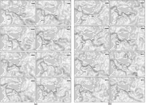
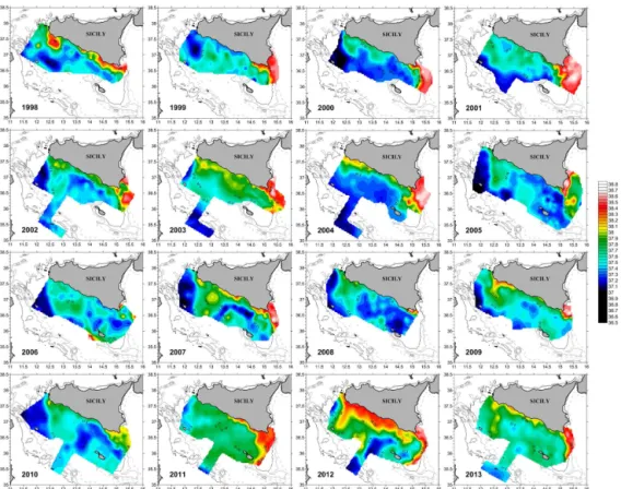
The geostrophic velocity field, evaluated for the CMED by means of the AVISO altimeter products, permitted the highlighting of the two main streams of AW: ATC and AIS (Fig. 5). The salinity profiles along transects perpendicular to the Sicily coast permitted checking the path of both streams in the study area (e.g. Fig. 6). The pattern of salinity mini-mum (Fig. 7) shows a variety of segmented structures, also confirming the complex circulation of surface water.
The interpretation of the density interfaces (not shown) and of geostrophic currents (Fig. 5) in the study period, highlights the presence of alternating cyclonic and anticy-clonic structures along the central part of the southern coast of Sicily (13.5–14◦E). The anticyclonic pattern operates a
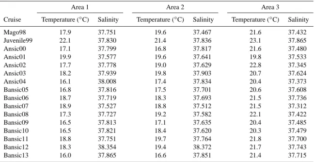
Table 2. Number of stations for each layer and average values and standard deviations (SDs) of salinity, potential temperature (◦C) and
potential density (kg m−3)for each survey. In the layer 0–200 m are also included transitional waters.
Layer 0–200 m Layer 200–500 m Layer 500–bottom
Cruise Number of Salinity Pot. temp. Density Number of Salinity Pot. temp. Density Number of Salinity Pot. temp. Density
stations ◦C kg m−3 stations ◦C kg m−3 stations ◦C kg m−3
Mago98 170 37.982 16.15 27.985 45 38.730 13.91 29.094 26 38.735 13.68 29.147
SD 0.437 2.36 0.870 0.040 0.14 0.057 0.006 0.05 0.005
Juvenile99 185 38.246 16.95 27.969 70 38.767 13.95 29.113 33 38.739 13.65 29.155
SD 0.393 3.55 1.074 0.017 0.1 0.031 0.018 0.11 0.009
Ansic00 303 38.172 15.92 28.174 85 38.776 14.00 29.109 16 38.762 13.73 29.157
SD 0.43 2.51 0.868 0.001 0.11 0.031 0.007 0.05 0.005
Ansic01 421 38.241 16.76 28.01 96 38.785 14.09 29.096 42 38.769 13.78 29.151
SD 0.444 3.10 0.994 0.032 0.21 0.057 0.01 0.07 0.008
Ansic02 275 38.139 16.79 27.943 94 38.788 14.08 29.102 42 38.763 13.75 29.153
SD 0.519 2.93 1.033 0.013 0.17 0.038 0.018 0.15 0.018
Ansic03 286 38.273 16.75 28.034 77 38.79 14.21 29.074 44 38.776 13.91 29.129
SD 0.455 3.69 1.184 0.017 0.17 0.041 0.011 0.07 0.009
Ansic04 234 38.147 16.20 28.008 84 38.803 14.15 29.098 42 38.785 13.89 29.139
SD 0.575 2.53 1.055 0.013 0.17 0.039 0.009 0.08 0.011
Bansic05 220 38.146 16.01 28.13 72 38.805 14.1 29.121 40 38.785 13.84 29.151
SD 0.487 3.00 0.973 0.018 0.15 0.031 0.009 0.08 0.01
Bansic06 242 38.189 17.09 27.882 51 38.793 14.01 29.119 23 38.764 13.8 29.152
SD 0.408 3.84 1.147 0.03 0.25 0.037 0.013 0.09 0.008
Bansic07 209 38.007 16.82 27.843 57 38.824 14.18 29.107 27 38.796 13.88 29.151
SD 0.559 2.6 0.988 0.024 0.25 0.078 0.015 0.05 0.012
Bansic08 153 38.031 16.59 27.919 49 38.807 14.23 29.094 27 38.773 13.99 29.133
SD 0.511 2.54 0.952 0.019 0.18 0.037 0.012 0.04 0.007
Bansic09 170 38.106 15.99 28.111 58 38.797 14.08 29.107 32 38.772 13.83 29.144
SD 0.516 2.5 0.915 0.018 0.17 0.036 0.009 0.06 0.005
Bansic10 236 38.005 16.07 27.934 79 38.792 14.06 29.106 29 38.78 13.84 29.146
SD 0.472 2.18 0.915 0.032 0.1 0.041 0.009 0.06 0.006
Bansic11 157 38.17 16.06 27.992 52 38.781 14.16 29.078 25 38.792 13.87 29.148
SD 0.334 2.72 1.024 0.055 0.14 0.063 0.008 0.06 0.007
Bansic12 202 38.393 16.72 28.143 56 38.824 14.27 29.087 36 38.788 13.91 29.137
SD 0.39 3.34 1.052 0.023 0.20 0.041 0.014 0.10 0.010
Bansic13 235 38.080 16.67 27.924 50 38.829 14.24 29.097 25 38.800 13.93 29.142
SD 0.438 2.75 0.886 0.015 0.19 0.036 0.012 0.09 0.009
Table 3. Mean temperature and salinity in the coastal upwelling region (areas 1 and 2) and in the control one (area 3).
Area 1 Area 2 Area 3
Cruise Temperature (◦C) Salinity Temperature (◦C) Salinity Temperature (◦C) Salinity
Mago98 17.9 37.751 19.6 37.467 21.6 37.432
Juvenile99 22.1 37.830 21.4 37.836 23.1 37.865
Ansic00 17.1 37.799 16.8 37.817 21.6 37.480
Ansic01 19.9 37.577 19.6 37.641 19.8 37.533
Ansic02 17.7 37.778 19.0 37.629 22.8 37.345
Ansic03 18.2 37.939 19.8 37.903 20.7 37.624
Ansic04 16.1 38.008 17.4 37.834 20.4 37.373
Bansic05 16.8 37.816 17.5 37.701 20.6 37.608
Bansic06 18.7 37.719 18.3 37.693 21.5 37.736
Bansic07 18.9 37.527 18.8 37.512 21.5 37.312
Bansic08 17.3 37.727 19.2 37.582 22.1 37.422
Bansic09 16.5 37.813 17.1 37.635 20.4 37.485
Bansic10 16.5 37.821 18.4 37.620 20.3 37.479
Bansic11 18.8 37.751 19.7 37.764 21.8 37.700
Bansic12 18.3 38.354 19.4 38.372 21.7 37.743
Figure 3. (a) Mean values of salinity minimum and salinity max-imum recorded in the period 1998–2013. (b) Mean potential tem-perature and (c) mean depth recorded at depth of salinity minimum and salinity maximum.
2004, 2005, 2008 and 2010 in Fig. 5). Nevertheless, in some years, even though such an anticyclonic pattern is present, fresh AW does not reach the Sicilian coasts (Figs. 5 and 7). The horizontal salinity patterns also show the presence of a thermohaline front east of the Strait of Sicily (∼15◦E),
Figure 4. Box plot of temperature and salinity in the layer 5–30 m for the upwelling areas (1 and 2) and the control area (3), identified in Fig. 1.
which indicates a sort of physical barrier to the dynamics of surface circulation (Fig. 7).
3.2 The intermediate layer
Theθ-S diagram (e.g. in Fig. 2) highlights the presence of an intermediate layer (200–500 m) of westward salty wa-ter of easwa-tern origin. In the easwa-tern part of the area, east of 15◦E, the presence of CIW was recorded during the 1999,
2000, 2001, 2006, 2012 and 2013 surveys (not shown). CIW and LIW are identified in the θ-S diagram (e.g. Fig. 2b), due to the deviation towards higher values of salinity. In the eastern part of the Strait of Sicily, the CIW is characterized by slightly higher levels of salinity, compared to LIW, with a potential temperature ofθ=14.5–15◦C and a density of
σ< 29.1 kg m−3.
In the present study, the maximum-salinity (Smax)value is
interpreted as a signature of LIW core in the study area; it is located between 200 and 350 m (Fig. 3c). Between the years 1998 and 2013, a general increase ofSmaxvalues, especially
in 2007 and 2013, has been recorded (Fig. 3a), while tem-perature (TSmax)and depth have more variability than trend
(Fig. 3). Mean values of Smax and TSmax are in the ranges
38.73–38.86 and 13.95–14.57◦C (Fig. 3), respectively.
Figure 5. Mean geostrophic velocity field (absolute dynamic topography by Aviso) estimated in the period of each survey. The patterns of the main circulation streams (ATC and AIS) are evaluated by the AVISO altimeter products.
Figure 6. Surface-salinity map, estimated in the oceanographic survey “Ansic 03” (left side). Salinity section (right side) and position of the main water masses along the selected transect (red box on the map) 250 km long .
for 2006, when a slight decrease in salinity was recorded (Fig. 8a). Afterwards, in the period 2007–2011, a decrease in salinity can be observed (Fig. 8b). Starting from 2011, the system seems to switch towards higher salinity levels up to 2013. Salinity and potential temperature for the period 1998– 2013 (Table 2), in the intermediate layer (200–500 m), are positively correlated with high values of Spearman’s correla-tion coefficient (r=0.71,p< 0.05).
3.3 The deepest layer
Even though the central basin, occupying a significant por-tion of the Strait, has a mean depth of about 800 m, it can be deeper in several trenches, reaching 1700 m. In deeper lay-ers, sea water displays lower temperatures and salinities than the LIW. In the Strait of Sicily, the tEMDW is characterized by a temperature minimum of 13.63◦C, a salinity of 38.73
and a density of 29.15 kg m−3. In this bottom layer, both
Figure 7. Horizontal distribution of the minimum salinity (Smin)in the Strait of Sicily and western Ionian Sea in the period 1998–2013.
Figure 8. 2-Sdiagrams of the intermediate layer in the Strait of Sicily (Station 945): (a) period 1998–2007 and (b) period 2007–2013.
(Table 2). Salinity and potential temperature in the period 1998–2013 show high values of Spearman’s correlation co-efficient (r=0.81,p< 0.05). This coefficient increases up to a maximum of 0.9 if the correlation is performed over the years 1998–2007.
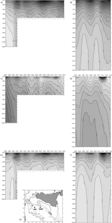
The entire water column has been characterized by an in-crease in salinity since 1998; especially between 2004 and 2005, there was a greater spread of salinity throughout the water column. The Hovmöller diagrams for the stations 945 and G605 (Fig. 9) show wide variation of density between 1998 and 2013. Unfortunately, the CTD profile in the station
945 was not always collected until the maximum depth (bot-tom); since 2003, the maximum depth was about 600 m.
The analysis of Fig. 9 evidences that the isopycnal 29.15 kg m−3has a depth in the range 500–700 m in the years
Figure 9. Hovmöller diagrams of potential temperature (a), salin-ity (c) and potential denssalin-ity (e) in the layer 200–1200 m in the sta-tion 945 (1200 m) for the period 1998–2013. Hovmöller diagrams of potential temperature (b), salinity (d) and potential density (f) in the layer 200–1700 m in the station G605 (1700 m) for the period 2003–2013. (e) Map with the position of the stations 945 and G605.
4 Discussion
The surface layer (0–200 m) in the CMED is known to be characterized by both intrannual and inter-annual high vari-ability (Gasparini et al., 2005; Ben Ismail et al., 2012). The time series of the salinity-minimum pattern and of geostrophic velocity fields confirm the complex
circula-tion of surface water, which, in this area, is dominated by mesoscale processes (Lermusiaux and Robinson, 2001; Sam-mari et al., 1999; Ben Ismail et al., 2012). Our data set high-lights significant variabilities in size, position and shape of the vortices, as well as the relative strength and the loca-tion of the AIS. In particular, the data confirm the permanent character of the Adventure-Bank Vortex (ABV) (Lermusiaux and Robinson, 2001) and of temperature and salinity fronts of the Ionian slope. Such thermohaline fronts, positioned in the southeastern part of the study area, are known to be able to promote concentration processes for small organisms in the upper water layer (Basilone et al., 2013; Bonanno et al., 2006).
The observed variability of surface circulation at sub-basin scale highlights that the “Maltese Channel Crest”, a summer mesoscale feature located northwest of Malta (Robinson et al., 1999) does not seem to be a permanent feature of the area, in agreement with previous studies (Béranger et al., 2004; Sorgente et al., 2011). The Ionian Shelf-Break Vortex (IBV) (Robinson et al., 1999) is part of the cyclonic circulation of the AIS in the easternmost part of the study area. Due to the sampling design coverage, in some surveys, CTD data were not collected on this vortex, even though the geostrophic ve-locity fields seem to suggest a permanent character of the IBV.
The analysed data set highlights that both AIS and ATC are permanent features of the area. Even though the sampling de-sign did not permit covering the whole path of both streams, the AIS seems to be more intense than ATC in the summer and typically characterized by high spatial variability, as also reported by Garcia Lafuente et al. (2005). ATC was partially recognized in the southern part of the central Strait of Sicily. Upwelling phenomenon along the southern coast of Sicily is a persistent feature of the area, as demonstrated by the col-lected CTD data set. One of the causes of this phenomenon is the inertia of the isopycnal domes of the AIS meanders and cyclonic vortices (Robinson et al., 1999). Westerly winds may reinforce coastal upwelling (wind-driven upwelling), while southerly winds may temporarily hide the upwelling effects from satellite observation.
For the first time in this area, the presence of WIW is evi-denced. This water mass is generated during the winter con-vection period in the northern area of the western Mediter-ranean Basin, as a result of surface cooling of the AW and mixing processes with LIW below (Conan and Millot, 1995; Gasparini et al., 1999; Ben Ismail et al., 2012). Generally, WIW forms a portion of the water column positioned be-tween 100 and 200 m depth with the same flow direction as the AW (Millot, 1999). Intermittent signal of the WIW in the Sicilian Channel has also been reported by Sammari et al. (1999), Lermusiaux and Robinson (2001) and Ben Ismail et al. (2012).
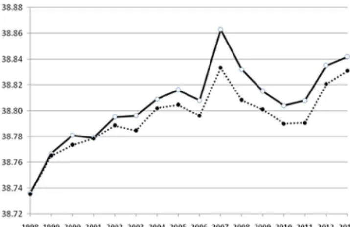
Figure 10. MeanSmaxvalues (continuous line) and mean salinity
(dotted line) in the density range 29.0–29.12 kg m−3.
and not in all the surveys, suggesting an expansion of WIW also in the western coastal waters of Sicily.
Ben Ismail et al. (2012) singled out the presence of the Io-nian water between the AW and the top of the LIW in the western side of the Strait of Sicily, with an east–west direc-tion. The analysed data set permits recognition of the Ionian waters in the eastern part of the Strait of Sicily and, in par-ticular, east of the 15◦E longitude (Fig. 2a). Moving
west-wards, the ISW signal is less marked, due to mixing with the surrounding waters.
In order to identify the LIW core, many authors use both the classical “core method” and the fairly fuzzy assumptions that the LIW upper and lower limits can be specified from the θ maximum andSmax(Millot, 2013). In the salinity profiles
collected in the Strait of Sicily,Smaxvalue is always evident,
at least in the salinity profiles of stations deeper than 200 m, while the presence of a relative maximum in theθ profile is rare. In agreement with Sparnocchia et al. (1994) and Gas-parini et al. (2008), we consideredSmaxas a signature of the
LIW core in the Strait of Sicily.
Taking into consideration one recent paper by Mil-lot (2013) on the Mediterranean waters (MWs), it could be “postulated that the average potential density that is represen-tative of some heat and salt content associated with a given MW (as well as with all MWs) would have to be maintained up to the Strait of Gibraltar . . . ”.
In this case, the author, analysing the 1985–1986 GIBEX data set, proposed a density range of 29.0–29.075 kg m−3for
the LIW core.
Nittis and Lascaratos (1998) proposed a slightly different density range for LIW (28.95–29.10 kg m−3), the density of
the LIW core being 29.05 kg m−3 for the eastern
Mediter-ranean Basin.
Astraldi et al. (2002a) evaluated an LIW density in the range 28.95–29.14 kg m−3for the western part of the Strait
of Sicily.
Taking all of these studies into account, and mainly theθ -Sprofiles collected over the whole study period (1998–2013) in the Strait of Sicily, the mean salinity per year in the den-sity range 29.0–29.12 kg m−3, where the LIW core is located,
has been evaluated (Fig. 10). The good agreement (r=0.99, p< 0.05) between the mean (per year)Smaxvalues and the
calculated mean salinity in the specified density range per-mits to use Smax to follow the variability of the LIW core
salinity in the Strait of Sicily.
In the eastern part of the area (longitude > 15◦E) the
pres-ence of Cretan intermediate water (CIW) was observed only in some surveys; possible mixing phenomena between LIW and CIW did not allow us to differentiate between the two water masses in all of the surveys. Differences between the two water masses are not evident within the Strait of Sicily. Recently, Millot (2013) proposed that the intermediate water, formed in all zones of dense-water formation in the Levan-tine Basin and flowing through the Strait of Sicily, should be renamed the eastern intermediate water (EIW).
2-Splots highlight different patterns in intermediate and deep waters between CTD casts collected east of 15◦E and
the those acquired in the central part of the Strait of Sicily (e.g. Fig. 2c). It is likely that mixing phenomena occur along the EIW path. Once they have reached the Strait, the interme-diate and deep waters maintain their physical characteristics along the entire area of the Strait.
Intermediate water of eastern origin enters the Strait of Sicily from the east through the large, relatively deep pas-sage between Malta and Libya (Manzella, 1994; Placenti et al., 2013). The LIW vein core is characterized by a maximum salinity located between 200 and 350 m; inside the central basin of the Sicilian Channel, the westward flow of LIW is observed along the Tunisian slope (e.g. Fig. 6) in agreement with previous studies (Ben Ismail et al., 2014).
starting from 2008. In 2012 and 2013, a further increase in salinity and temperature is observed.
During the mid-1990s, a significant volume of tEMDW is found below the LIW (Sparnocchia et al., 1999), which is the result of mixing between the LIW, the old EMDW and the new EMDW, originated from the EMT (Roether et al., 1996, 2007). These waters display lower temperatures and salinities than the LIW. The LIW and tEMDW exit the Strait of Sicily into the Tyrrhenian Sea as two independent veins adjacent to the western Sicilian slope (Astraldi et al., 2002b). Our data set indicates that, since 1998, an increase in tem-perature and salinity is recorded in the bottom layer; espe-cially between 2004 and 2005, there was a greater spread of salinity throughout the water column, in agreement with Gaˇci´c et al. (2013) and Ben Ismail et al. (2014). The poten-tial temperature shows a positive trend from 1998 to 2005, with maximum values recorded in 2003 (θ=13.91◦C). A
further phase of maximum spread of salinity in the water column is evident between 2007 and 2008. Specifically, in 2007, there was the maximum value of salinity (38.8), while the maximum value of potential temperature was recorded in 2008 (θ=13.99◦C). In this phase, the bottom layer is
char-acterized by the presence of lighter water. In 2006 and 2009, we found different conditions to those described above. In particular, in 2006, there was an abrupt decrease of potential temperature (θ=13.76◦C) and salinity (38.76), and
simul-taneously an increase of density (σ< 29.152 kg m−3) (see
Fig. 9). These findings indicate the presence of a large vol-ume of tEMDW in the Strait of Sicily, in agreement with Ben Ismail et al. (2014).
Similar reductions in potential temperature and salinity of deeper waters were also observed during the 2009 survey. This result likely suggests the enhancement of the passage of volume of tEMDW also in 2009. After 2009 and until 2013, there was a new salt phase that influenced the entire water column.
5 Conclusions
The analysed data set allowed to study the high inter-annual water-mass variability in the Strait of Sicily. The obtained results, supported by a large data set both in terms of area covered (sampling intensity) and time interval, highlighted how the Strait of Sicily is an important site for studying the effects of surface and intermediate water circulation at sub-basin scale. The analysis of data permitted the study of the permanent character of the main mesoscale features of sur-face circulation, while the observed trend ofSmaxin the
in-termediate water layer seems to be linked to the circulation of the upper layer in the central Ionian Sea (BiOS).
Although the area of the Strait of Sicily is limited at the east and west by two relatively shallow sills, in some parts bottom depth can reach 1700 m. The acquired CTD profiles in such deeper areas allowed us to study the evolution of the
tEMDW characteristics over the period 1998–2013. The re-sults obtained stressed the importance of a continuous moni-toring program of deeper water layer in the Strait of Sicily.
Acknowledgements. The study was mainly supported by the
Uf-ficio Programmazione Operativa of the Consiglio Nazionale delle Ricerche. The FAO MedSudMed Project, funded by the Italian Min-istry MIPAAF, and the RITMARE Project, funded by the Italian Ministry MIUR, are thanked for their support in the last oceano-graphic surveys.
Mr. Emanuele Gentile and Mr. Vincenzo Lubrano, Masters of the R/V Urania, and all of their crew are thanked for their work. All of the participating institutes and scientists who were on board are gratefully acknowledged for their involvement in the work carried out.
Edited by: J. M. Huthnance
References
Astraldi, M., Gasparini, G. P., Vetrano, A., and Vigudelli, S.: Hy-drographic characteristics and interannual variability of water masses in the central Mediterranean: a sensitivity test for long-term changes in the Mediterranean Sea, Deep Sea Res. I, 49, 661–680, 2002a.
Astraldi, M., Conversano, F., Civitarese, G., Gasparini, G. P., Ribera d’Alcalà, M., and Vetrano, A.,: Water mass properties and chem-ical signatures in the central Mediterranean region, J. Mar. Syst., 33–34, 155–177, 2002b.
Basilone, G., Bonanno, A., Patti B., Mazzola S., Barra M., Cuttitta A., and McBride R.: Spawning site selection by European an-chovy (Engraulis encrasicolus) in relation to oceanographic con-ditions in the Strait of Sicily, Fish. Oceanogr., 22, 309–323, 2013. Ben Ismail, S., Sammari, C., Gasparini, G. P., Béranger, K., Brahim, M., and Aleya, L.,: Water masses exchanged through the Channel of Sicily: evidence for the presence of new water masses on the Tunisian side of the Channel, Deep Sea Res. I, 63, 65–81, 2012. Ben Ismail, S., Schroeder, K., Sammari, C., Gasparini, G. P., Borgh-ini, M., and Aleya, L.: Interannual variability of water mass prop-erties in the Tunisia-Sicily Channel, J. Mar. Syst., 135, 14–28, 2014.
Béranger, K., Mortier, L., Gasparini, G. P., Gervasio, L., Astraldi, L., and Crépon, M.: The dynamics of the Sicily Strait: a compre-hensive study from observations and models, Deep-Sea Res. II, 51, 411–440, 2004.
Bonanno, A., Goncharov, S., Mazzola, S., Popov, S., Cuttitta, A., Patti, B., Basilone, G., Di Nieri, A., Patti, C., Aronica, S., and Buscaino, G.: Acoustic evaluation of anchovy larvae distribution in relation to oceanography in the Cape Passero area (Strait of Sicily), Chem. Ecol., 22, S265–S273, 2006.
Borzelli, G. L. E., Gaˇci´c, M., Cardin, V., and Civitarese, G.: Eastern Mediterranean transient and reversal of the Ionian Sea circulation, Geophys. Res. Lett., 36, L15108, doi:10.1029/2009GL039261, 2009.
Brankart, J. M.: The MODB local quality control, Technical Report, University of Liege, Liege, p. 5., 1994.
Conan, P. and Millot, C.: Variability of the northern current off Mar-seilles, Western Mediterranean Sea, from February to June 1992, Oceanol. Acta, 18, 193–205, 1995.
Conover, W. J.: Practical Nonparametric Statistics, Third Edition, New York: John Wiley & Sons, 1999.
Demirov, E. and Pinardi, N.: Simulation of the Mediterranean Sea circulation from 1979 to 1993: Part I, The interannual variability, J. Marine Syst., 33–34, 23–50, doi:10.1016/S0924-7963(02)00051-9, 2002.
Gaˇci´c, M., Borzelli, G. L. E., Civitarese, G., Cardin, V., and Yari, S.: Can internal processes sustain reversals of the ocean upper circulation?: The Ionian Sea example, Geophys. Res. Lett., 37, L09608, doi:10.1029/2010GL043216, 2010.
Gaˇci´c, M., Civitarese, G., Eusebi Borzelli, G. L., Kovaˇcevi´c, V., Poulain, P.-M., Theocharis, A., Menna, M., Catucci, A., and Zarokanellos, N.: On the relationship between the decadal oscil-lations of the Northern Ionian Sea and the salinity distributions in the Eastern Mediterranean, J. Geophys. Res., 116, C12002, doi:10.1029/2011JC007280, 2011.
Gaˇci´c, M., Schroeder, K., Civitarese, G., Cosoli, S., Vetrano, A., and Eusebi Borzelli, G. L.: Salinity in the Sicily Channel corrobo-rates the role of the Adriatic-Ionian Bimodal Oscillating System (BiOS) in shaping the decadal variability of the Mediterranean overturning circulation, Ocean Sci., 9, 83–90, doi:10.5194/os-9-83-2013, 2013.
Garcia Lafuente, J., Vargas, J. M., Criado, F., Garcia, A., Del-gado, J., and Mazzola, S.: Assessing the variability of hydro-graphic processes influencing the life cycle of the Sicilian Chan-nel anchovy, Engraulis encrasicolus, by satellite imagery, Fish. Oceanogr. 14, 32–46, 2005.
Gasparini, G. P., Zodiatis, G., Astraldi, M., Galli, C., and Sparnoc-chia, S.: Winter Intermediate Water lenses in the Ligurian Sea, J. Mar. Syst., 20, 319–332, 1999.
Gasparini, G. P., Ortona, A., Budillon, G., Astraldi, M., and San-sone, E.: The effect of the Eastern Mediterranean Transient on the hydrographic characteristics in the Strait of Sicily and in the Tyrrhenian Sea, Deep-Sea Res. Pt. I, 52, 915–935, 2005. Gasparini, G. P., Bonanno, A., Zgozi, S., Basilone, G., Borghini,
M., Buscaino, G., Cuttitta, A., Essarbout, N., Mazzola, S., Patti, B., Ramadan, A. B., Schroeder, K., Bahri, T., and Massa, F.: Evi-dence of a dense water vein along the Libyan continental margin, Ann. Geophys., 26, 1–6, doi:10.5194/angeo-26-1-2008, 2008. Lermusiaux, P. F. J.: Estimation and study of mesoscale
variabil-ity in the Strait of Sicily, Dynam. Atmos. Oceans, 29, 255–303, 1999.
Lermusiaux, P. F. J. and Robinson, A. R.: Features of dominant mesoscale variability, circulation patterns and dynamics in the Strait of Sicily, Deep-Sea Res. Pt. I., 48, 1953–1997, 2001.
Manzella, G.: The Seasonal variability of the water masses and transport through the Strait of Sicily, Coastal and Estuarine Stud-ies, 46, 33–45, American Geophysical Union, 1994.
Millot, C.: Circulation in theWestern Mediterranean Sea, J. Marine Syst., 20, 423–442, 1999.
Millot, C.: Levantine Intermediate Water characteristics: an as-tounding general misunderstanding, Sci. Mar., 77, 217–232, doi:10.3989/scimar.03518.13A, 2013.
Nittis, K. and Lascaratos, A.: Diagnostic and prognostic numerical studies of LIW formation, J. Marine Syst., 18, 179–195, 1998. Placenti, F., Schroeder, K., Bonanno, A., Zgozi, S., Sprovieri, M.,
Borghini, M, Rumolo, P., Cerrati, G., Bonomo, S., Genovese, S., Basilone, G., Haddoud, D. A., Patti, B. , El Turki, A., Hamza, M., and Mazzola, S.: Water masses and nutrient distribution in the Gulf of Syrte and between Sicily and Libya, J. Marine Sys., 121–122, 36–46, 2013.
Robinson, A. R., Sellschopp, J., Warn-Varnas, A., Leslie, W. G., Lozano, C. J., Haley, P. J., Anderson, L. A., and Lermusiaux, P. F. J.: The Atlantic Ionian Stream, J. Marine Syst., 20, 129–156, 1999.
Roether, W., Manca, B. B., Klein, B., Bregant, D., Georgopoulos, D., Beitzel, V., Kovacevich, V., and Luchetta, A.: Recent changes in Eastern Mediterranean deep waters, Science 271, 333–335, 1996.
Roether, W., Klein, B., Manca, B. B., Theocaris, A., and Kioroglou, S.: Transient Eastern Mediterranean deep waters in response to massive dense-water output of the Aegean Sea in the 1990s, Prog. Oceanogr., 74, 540–571, 2007.
Sammari, C., Millot, C., Taupier-Letage, I., Stefani, A., and Brahim, M.: Hydrological characteristics in the Tunisian-Sardinia-Sicily area during spring 1995, Deep-Sea Res. Pt. I, 46, 1671–1703, 1999.
Schroeder, K., Taillandier, V., Vetrano, A., and Gasparini, G. P.: The circulation of the Western Mediterranean Sea in spring 2005 as inferred from observations and from model outputs, Deep-Sea Res. Pt. I, 55, 947–965, 2008.
Sorgente, R., Drago, A. F., and Ribotti, A.: Seasonal variability in the Central Mediterranean Sea circulation, Ann. Geophys., 21, 299–322, doi:10.5194/angeo-21-299-2003, 2003.
Sorgente, R., Olita, A., Oddo, P., Fazioli, L., and Ribotti, A.: Nu-merical simulation and decomposition of kinetic energy, Ocean Sci., 7, 503–519, doi:10.5194/os-7-503-2011, 2011.
Sparnocchia, S., Manzella, G. M. R., and La Violette, P. E.: The Interannual and Seasonal Variability of the MAW and LIW Core Properties in the Western Mediterranean Sea, Coast. Estuar. Stud., 46, 177–194, 1994.