Adv. Geosci., 22, 125–137, 2009 www.adv-geosci.net/22/125/2009/
© Author(s) 2009. This work is distributed under the Creative Commons Attribution 3.0 License.
Advances in
Geosciences
Volcanism and associated hazards: the Andean perspective
R. I. Tilling
Scientist Emeritus, Volcano Hazards Team, US Geological Survey, Menlo Park, California 94025-3591, USA Received: 30 June 2009 – Revised: 8 August 2009 – Accepted: 9 August – Published: 14 December 2009
Abstract.Andean volcanism occurs within the Andean Vol-canic Arc (AVA), which is the product of subduction of the Nazca Plate and Antarctica Plates beneath the South Amer-ica Plate. The AVA is Earth’s longest but discontinuous continental-margin volcanic arc, which consists of four dis-tinct segments: Northern Volcanic Zone, Central Volcanic Zone, Southern Volcanic Zone, and Austral Volcanic Zone. These segments are separated by volcanically inactive gaps that are inferred to indicate regions where the dips of the subducting plates are too shallow to favor the magma gen-eration needed to sustain volcanism. The Andes host more volcanoes that have been active during the Holocene (past 10 000 years) than any other volcanic region in the world, as well as giant caldera systems that have produced 6 of the 47 largest explosive eruptions (so-called “super eruptions”) rec-ognized worldwide that have occurred from the Ordovician to the Pleistocene.
The Andean region’s most powerful historical explosive eruption occurred in 1600 at Huaynaputina Volcano (Peru). The impacts of this event, whose eruptive volume exceeded 11 km3, were widespread, with distal ashfall reported at
dis-tances>1000 km away. Despite the huge size of the Huayna-putina eruption, human fatalities from hazardous processes (pyroclastic flows, ashfalls, volcanogenic earthquakes, and lahars) were comparatively small owing to the low popula-tion density at the time. In contrast, lahars generated by a much smaller eruption (<0.05 km3)in 1985 of Nevado del Ruiz (Colombia) killed about 25 000 people – the worst vol-canic disaster in the Andean region as well as the second worst in the world in the 20th century. The Ruiz tragedy has been attributed largely to ineffective communications of haz-ards information and indecisiveness by government officials, rather than any major deficiencies in scientific data. Ruiz’s
Correspondence to:R. I. Tilling ([email protected])
disastrous outcome, however, together with responses to sub-sequent hazardous eruptions in Chile, Colombia, Ecuador, and Peru has spurred significant improvements in reducing volcano risk in the Andean region. But much remains to be done.
1 Introduction
Fig. 1. The prominent mountainous belt making up the Andean chain (Cordillera de Los Andes) stretches approximately 8000 km north to south from Venezuela to Patagonian Chile along the west-ern margin of South American continent. The Andes – the “back-bone” of South America – are clearly seen in this Radar Shuttle To-pography image. (SRTM NASA/JPL, http://photojournal.jpl.nasa. gov/tiff/PIAO3388.tif).
2 Andean Volcanic Arc (AVA)
The Andean range has formed by the subduction of the Nazca and Antarctica Plates beneath the South America Plate since at least the late Paleozoic (Fig. 2). Plate-tectonics processes have also developed and sustained the Andean Volcanic Arc (AVA), which contains numerous volcanoes, including Earth’s highest volcano, Nevados Ojos del Sal-ado (Chile), whose summit is 6887 m a.s.l. Moreover, the AVA hosts more large composite volcanoes (122) that have erupted during the Holocene than any other volcanic region (Simkin and Siebert, 1994); many of these topographically high, steep-sided volcanoes have summits capped by ice and snow. At such volcanoes, there exists great potential for the generation of far-travelling destructivelahars(volcanic mud-flows) during and following eruptions, thereby making them exceptionally hazardous. For example, during the 1877 erup-tion of Cotopaxi Volcano (Ecuador), devastating lahars swept
Fig. 2.The Andean Volcanic Arc (AVA) has formed by the
subduc-tion of the Nazca and Antarctica Plates beneath the South America Plate. The present-day AVA is well expressed by the string of An-dean volcanoes that have been active since the Holocene, as delin-eated by the solid and open red triangles on this portion of the world plate tectonics map of Simkin et al. (2006). The circles (black, white, and open) mark earthquakes of magnitude 5 or greater; the segmented red lines show divergent plate boundaries.
down valleys draining the volcano; the largest lahars traveled >300 km to reach the Pacific Ocean (Mothes et al., 2004; Kumagai et al., 2007; Hall and Mothes, 2008).
It is beyond the scope of this paper to discuss the AVA in detail. For a helpful introduction to Andean magmatism and associated volcanism, the interested reader should con-sult available summary works and references cited therein (e.g., Barberi et al., 1988; M´endez Fajury, 1989; De Silva and Francis, 1991; Gonz´alez-Ferr´an, 1995; Stern, 2004; Hall et al., 2008). The following two websites also provide useful information about Holocene volcanoes in South America:
– http://www.volcano.si.edu/world/region.cfm?rnum= 15{\&}rpage=list>; and
– http://mineralsciences.si.edu/tdpmap.
As discussed in the sections to follow, dozens of Andean vol-canoes have erupted powerfully in the geologic past as well as during historical time.
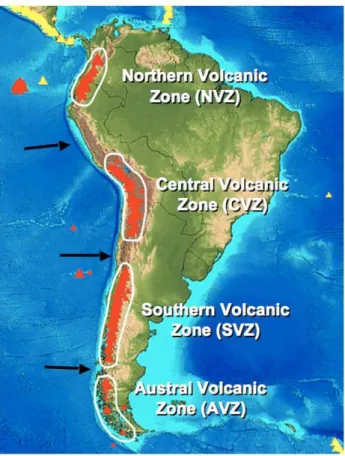
The AVA is Earth’s longest continental-margin volcanic arc (>8000 km long), but it is not continuous along its length. Instead, it consists of four distinct segments (Fig. 3): the Northern Volcanic Zone (NVZ), along Colombia and Ecuador; theCentral Volcanic Zone(CVZ), extending from southern Peru to northern Chile; theSouthern Volcanic Zone
(SVZ), encompassing central and southern Chile; and the
R. I. Tilling: Volcanism and associated hazards: the Andean perspective 127
Fig. 3. The Andean Volcanic Arc is not continuous and consists
of four segments, which are separated by volcanically inactive gaps hundreds of kilometers in length (see text). The black arrows mark regions where the subduction angle is relatively flat.
hundreds of kilometers in length. There is no general agree-ment about the reason(s) for the segagree-mentation of the An-dean volcanic arc. However, a commonly invoked hypothe-sis (e.g., Stern, 2004) is that these gaps coincide with regions where the dips of the subducting plates are too shallow (∼10◦
or less at depths>100 km) to favor generation of magma by partial melting in hot mantle that sustains volcanism.
3 Andean eruptions over geologic time 3.1 The Volcanic Explosivity Index (VEI)
Before discussing eruptions in the Andean region, to provide global and historical context, it is useful to review briefly the Volcanic Explosivity Index (VEI) devised by Newhall and Self (1982). This semi-quantitative, logarithmic VEI scale has become the tool most widely used by volcanol-ogists to estimate the relative size or magnitude of an ex-plosive eruption. The open-ended VEI scale applies only to explosive eruptions, with the VEI value determined primar-ily by the volume of eruptive products, height of the erup-tion cloud, and eruperup-tion duraerup-tion, but with qualitative
obser-Fig. 4. Histogram of Holocene eruptions for which VEIs (see text
for discussion) have been assigned; note the break in scale in the vertical axis. The number of eruptions with assigned VEIs≤2 (total of 5349 events) is not plotted because of scale limitation. Numbers highlighted in yellow give the number of eruptions of in each VEI ranking, as compiled in the Volcano Database of the Smithsonian Institution (Simkin and Siebert, 1994). A few selected historical eruptions mentioned in this paper are given to provide illustrative examples (Andean eruptions highlighted in blue).
vations of explosivity (e.g., “gentle,” “cataclysmic,” “colos-sal”) also considered. A non-explosive eruption is assigned a VEI of 0 regardless of size, and an increase of 1 in the VEI corresponds to an eruption roughly 10 times more “power-ful.” In general, the longer the repose interval between erup-tions, the more explosive (i.e., resulting in a higher VEI) is the next eruption (Simkin and Siebert, 1994). Figure 4 is a summary of explosive eruptions in the world during the Holocene ranked by VEI; note that no Holocene eruption is ranked higher than VEI 7. The 1815 eruption of Tambora Volcano (Indonesia) – the largest in the world in recorded history – is the only historical volcanic event to be assigned VEI 7 (Fig. 4).
3.2 Pre-Holocene Andean “super eruptions”
Table 1. Quaternary Andean “super eruptions” from caldera/ignimbrite systems in the Altiplano-Puna plateau of the central Andes. A “super eruption” is defined by Mason et al. (2004) as one erupting≥1015kg of ejecta; Ma=millions of years ago. (Data source: Mason et al., 2004, Table 2).
Caldera Eruptive deposit(s) Geologic
(ignimbrites) age (Ma)
Cerro Galan, Argentina Cerro Galan 2.2
La Pacana, Chile Atana ∼4
Cerro Galan, Argentina Real Grande, Cueva Negra 4.2
Unknown, central Andes Huaysillas 5
Cerro Panizos, central Andes Panizos 6.1
Pastos Grandes, central Andes Sifon 8.3
eruptive mass, is proportionately comparable to the VEI scale (based on eruptive volume) but differs by taking into account the estimated bulk density of eruptive deposits. As defined by Mason et al. (2004), a M-8 eruption has an eruptive mass of >1015kg, or about 150 times more than was erupted during the 1991 eruption of Mount Pinatubo (Newhall and Punong-bayan, 1996), the second largest in the world in the 20th cen-tury.
About a dozen giant caldera/ignimbrite systems are lo-cated within the Altiplano-Puna plateau of the central Andes (Allmendinger et al., 1997; Stern, 2004). Of the “super erup-tions” recognized worldwide, 6 of them have occurred within the central Andes during the period between 9 and 2 million years (Table 1). Thus, the Andean region has had its fair share of Earth’s “super eruptions” in the geologic past. Al-though it’s unlikely that super eruptions have stopped in the Andean or any other volcanic region, fortunately they are in-frequent, and the odds of another in the near (foreseeable?) future are small. Yet, it should be mentioned that volcanic unrest – involving seismicity and ground deformation – has been documented for some caldera systems in the world (e.g., Newhall and Dzurisin, 1988; Waite and Smith, 2002; Hill, 2006; Wicks et al., 2006; Troise et al., 2007). As an An-dean example, caldera-scale ground deformation (involving an area ∼1100 km2) at the Lazufre volcanic center, docu-mented by Interferometric Synthethic Radar (InSAR) stud-ies, has been inferred to represent inflation of a subsurface magma reservoir (Froger et al., 2007; Ruch et al., 2008). 3.3 Holocene and historical Andean volcanism
The Andes host 204 of the approximately 1500 volca-noes active during the Holocene (past 10 000 years) world-wide – more than any other volcanic region (Simkin and Siebert, 1994). According to the global volcano database of the Smithsonian Institution as compiled by Simkin and Siebert (1994), Andean volcanoes have produced about 18 percent of the∼500 Holocene eruptions that are ranked VEI 4 or greater (Fig. 4). The Andean region contains 66 of
Table 2. Largest explosive eruptions in the Andean region during
the 19th–21st centuries, with assigned Volcanic Explosivity Index (VEI) equal to or greater than 4 (see text for discussion). Data sources: Simkin and Siebert (1994); GVPc (2009).
Year Eruption VEI
1877 Cotopaxi, Ecuador 4
1886 Tungurahua, Ecuador 4
1893 Calbuco, Chile 4
1899 Dona Juana, Colombia 4 1918 Tungurahua, Ecuador 4 1932 Quizapu (Cerro Azul), Chile 5+ 1955 Carran-Los Venados, Chile 4 1991 Cerro Hudson, Chile 5+
1993 Lascar, Chile 4
2002 Reventador, Ecuador 4
2008 Chait´en, Chile 5?
Fig. 5.Histogram of historically active volcanoes grouped by
coun-try; the numbers in parentheses indicate the number of individual volcanoes. The Andean countries combined (highlighted by red outlines) host 66 of the∼550 historically active volcanoes world-wide (primary data source: Simkin and Siebert, 1994).
R. I. Tilling: Volcanism and associated hazards: the Andean perspective 129
Fig. 6. Sketch map showing the regional ashfall from the 1600 AD eruption of Huaynaputina Volcano (southern Peru), Central Volcanic
Zone of the Andean Volcanic Arc. The area within the 1 m isopach (dark grey) was devastated by pyroclastic flows and surges and heavy ashfall; the solid black squares indicate villages buried by ash (from Thouret et al., 2002, Fig. 1).
3.4 Some powerful historical Andean eruptions
The Andean region’s most powerful historical explosive eruption occurred on 19 February 1600 at Huaynaputina Vol-cano, Peru. This eruption is the only one in the Andes as-signed a VEI of 6 (Fig. 4). Even though the population in the affected region was relatively small at the time, the impacts of such a large eruption were still extremely destructive. An extensive area (∼950 km2)immediately to the west of
Huay-naputina was devastated by pyroclastic flows and surges and heavy ashfalls (Fig. 6). The city of Arequipa,∼75 km NW of the volcano, was severely damaged by eruption-associated earthquakes and ashfalls. Distal ashfalls were reported at Lima, Peru, La Paz, Bolivia, and Arica, Chile, as well as on a ship 1000 km to the west of the Pacific coast. Eruption-triggered lahars traveled more than 100 km to enter the Pa-cific Ocean (De Silva and Zielinski, 1998; Adams et al., 2001; Thouret et al., 1999, 2002). In all, more than 1500 people were killed by the pyroclastic flows, ashfalls, earth-quakes, and lahars. While controversial, some studies (e.g., De Silva and Zielinski, 1998; Verosub and Lippmann, 2008; Briffa et al., 1998) suggest that the eruption also may have affected global climate, with the winter of 1600–1601 being the coldest in the Northern Hemisphere in the past 500 years. Now in the 21st century, with greatly increased populations of the Andean countries, the occurrence a
Huaynaputina-size eruption would cause many more fatalities, major socio-economic loss, and hardships for people in the Andean re-gion.
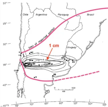
Following the 1600 Huaynaputina eruption, the two next largest Andean eruptions took place in Chile: Quizapu (Cerro Azul) in 1932 and Cerro Hudson in 1991. The Quizapu eruption, which ejected∼9.5 km3of material (Hil-dreth and Drake, 1992), was the largest eruption of any Andean volcano in the 20th century. This eruption pro-duced heavy ashfalls that drifted downwind to the east (Fig. 7); distal ashfall was even reported in Rio Janeiro, Brazil (Gonz´alez-Ferr´an, 1995). Even though the volcano is located in a remote part of Chile and ashfalls mostly affected sparsely populated parts of neighboring Argentina (Fig. 7), ashfalls locally killed livestock and caused mod-erate to severe damage to agricultural lands. Significantly, the Quizapu eruption, though very powerful, produced no eruption-related human fatalities.
com-Fig. 7. Isopach map of the ashfall from the 1932 Quizapu (Cerro Azul) eruption, Chile. The thin-line isopachs are for uncompacted ash (from Larsson, 1937), and the heavy-line isopachs are those measured by Hildreth and Drake (1992) during 1980–1991. The limit of reported ashfall is indicated by heavy red line, and the 1 cm isopach by the red arrow (from Hildreth and Drake, 1992, Fig. 1).
pares the 1600 Huaynaputina eruption with the largest ex-plosive eruptions of the 19th and 20th centuries worldwide; note that 3 of the 7 largest historical eruptions occurred in the Andean Volcanic Arc.
4 Volcano hazards and disasters
Eruptive processes and products associated with arc volca-noes, such as those in the Andes, can pose significant hazards if they impact populated regions, agricultural areas, trans-portation and utility networks, and other societal infrastruc-tures. Inasmuch as the literature on volcano hazards, volcano monitoring, and reduction of volcano risk is vast, this brief paper only will mention selected aspects germane to recent Andean eruptions. For a comprehensive introduction to vol-cano hazards and monitoring studies, the interested reader should consult summary works and references cited therein (e.g., Blong, 1984; Tilling, 1989, 2005; Scarpa and Tilling, 1996; Chouet, 2004; Dzurisin, 2006).
Globally, Indonesia has suffered the most eruption-related deaths (∼61%) from historical eruptions (Fig. 9). This ob-servation is not surprising given that Indonesia has the most historically active volcanoes (Fig. 5) and the country’s high population density, especially the Island of Java. Yet, even though South America has fewer historically active volca-noes than Indonesia, much smaller population, and lower
Table 3. The 1600 Huaynaputina eruption compared with the
largest explosive eruptions of the 19th and 20th centuries world-wide. VEI=Volcanic Explosivity Index;∗Andean eruption. Note the wide range of estimated bulk volumes for the Huaynaputina and Tambora eruptions. (Various data sources, including: Naranjo et al., 1993; Simkin and Siebert, 1994; De Silva and Zielinksi, 1998; Hildreth and Drake, 1992; Thouret et al., 2002; Mason et al., 2004).
Year Eruption VEI Bulk volume
(km3)
1600 Huaynaputina, Peru* 6 11–19
1815 Tambora, Indonesia 7 30–150
1883 Krakatau, Indonesia 6 ∼18
1912 Novarupta, USA 6 ∼15
1932 Quizapu (Cerro Azul)*Chile 5+ >9 1991 Mount Pinatubo, Philippines 6 ∼10
1991 Cerro Hudson, Chile* 5+ ∼8
population density, it ranks third (∼9.5%) in terms of erup-tion fatalities (Fig. 9). This apparent anomaly is readily ex-plained by the disastrous outcome of a single Andean erup-tion in 1985 at Nevado del Ruiz, Colombia (discussed be-low).
4.1 Recent notable eruptions
Nevado del Ruiz, Colombia, 1985. Following nearly a year of volcano unrest, which was being monitored by an in-ternational scientific team, the 5321 m-high, glacier-capped Ruiz Volcano erupted explosively on 13 November 1985 (Williams, 1990a, b; Voight, 1994). Its bulk eruptive volume (<0.05 km3) was orders of magnitude smaller than those
of many other historical Andean eruptions. Nonetheless, hot pyroclastic ejecta melted the ice and snow around the volcano’s summit, and the resulting meltwater mixed with the volcanic and other unconsolidated debris to generate la-hars. These lahars then swept rapidly down several steep val-leys draining the volcano, scouring and entraining material eroded en route (“bulking up”), before inundating the popu-lated and cultivated areas down valley. Deadly lahars obliter-ated everything in their paths and killed about 25 000 people, nearly 23 000 in the city of Armero alone (Fig. 10). The dis-proportionately high death toll from the 1985 Ruiz eruption (VEI 3?) can be appreciated by comparing it with fatalities caused by other deadly historical eruptions worldwide, all of which were much larger in size (Fig. 11).
R. I. Tilling: Volcanism and associated hazards: the Andean perspective 131
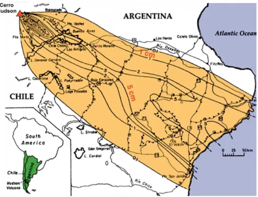
Fig. 8.Isopach map of the ashfall from the 1991 Cerro Hudson eruption, Chile. The 1 cm and 5 cm isopachs are indicated by red labels (from
Scasso et al., 1994, Fig. 1).
have been documented in numerous post-1985 studies (e.g., Williams, 1990a, b; Voight, 1994). With minor differences in emphasis, these studies all basically conclude that the Ruiz tragedy happened because of: 1) ineffective communications among scientists, civil authorities, and the populations at risk; and 2) emergency-management officials failed to act in a timely fashion, despite having advance, though imper-fect warnings given by scientists. The conclusion of Voight (1996, p. 719) aptly conveys what went wrong at Ruiz:
“Scientific studies foresaw the hazards – including the recognition that several towns were in the “wrong place,” vulnerable to lahars generated by eruption-induced snowmelt – but were insufficiently precise to prompt reliable warn-ing of the crucial event before the last possible minute. The catastrophe was not caused by technological ineffectiveness or defectiveness, nor by an overwhelming eruption or an im-probable run of bad luck, but rather by cumulative human error.” (italics added).
The Ruiz tragedy shocked the world and spurred the gov-ernment of Colombia to greatly augment the monitoring of its hazardous volcanoes. Since 1985, the country has es-tablished three modern volcano observatories – located in Manizales, Pasto, and Popay´an – operated by the Instituto Colombiano de Geolog´ıa y Miner´ıa (INGEOMINAS). More-over, in the decades following the disastrous outcome of the Ruiz eruption, as well as the occurrence of subsequent vol-canic crises, also prompted the establishment or the mod-ernization of volcano observatories in Chile (Observatorio Volcanol´ogico de los Andes del Sur), Ecuador (Instituto
Geof´ısico-Escuela Polit´ecnica Nacional), and Peru (Instituto Geof´ısico del Per´u and the Observatorio Volcanl´ogica de Arequipa). The 1985 Ruiz disaster served to energize the global volcanological community, and the response in the U.S. was to develop the Volcano Disaster Assistance Pro-gram (VDAP), discussed later (see Sect. 6).
Fig. 9.Histogram of eruption-related deaths worldwide (∼300 000) since 1600 AD grouped according to country or volcanic region. Numbers in parentheses give the percentages of worldwide deaths for each region. South America ranks third in eruption fatalities, which overwhelmingly reflect a single event, the Ruiz volcanic dis-aster in 1985 (see text) (primary data source: Simkin and Siebert, 1994).
of comparable size and both involved lahar hazards. The 2007 Nevado del Huila case history is an illustrative example of the substantial progress being made in the Andean coun-tries in responding to volcanic crises.
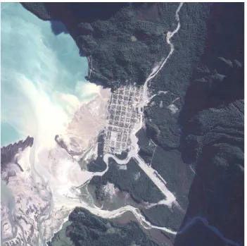
Volc´an Chait´en, Chile, 2008-present. On 2 May 2008, Chait´en Volcano erupted explosively after less than 36 h of precursory seismicity (recorded by instruments∼300 km distant) and produced an ash plume that rose 21 km into the atmosphere (Lara, 2009; Carn et al., 2009). This event marks the first historical eruption of Chait´en; its previous eruption occurred about 9400 years ago (Naranjo and Stern, 2004). Scientists of Chile’s Servicio Nacional de Geolog´ıa y Miner´ıa (SERNAGEOMIN) immediately worked with re-gional and national government authorities to assess the po-tential hazards and volcanic crisis (Lara, 2009; Moreno and Lara, 2008). During 4–5 May, emergency-management of-ficials ordered the immediate evacuation of about 5000 in-habitants at risk (Lara, 2009). This timely and quickly exe-cuted action doubtless saved many lives, given that the city of Chait´en was devastated by lahars and floods shortly there-after, on 12 May (Fig. 12a).
Between 2 May and 8 May, Chait´en produced three high ash plumes that drifted downwind across neighboring Ar-gentina (Fig. 12b). Heavy ashfalls from these plumes not only blanketed settlements around Chait´en but also adversely affected extensive areas of neighboring Argentina downwind (e.g., Folch et al., 2008; Horwell et al., 2008; Martin et al., 2009; Watt et al., 2009). Explosive activity then subsided, and a new lava dome was observed within the crater on 21 May, even though dome extrusion probably began days ear-lier. As of this writing (August 2009), Chait´en remains active and the lava dome complex continues to grow, accompanied by small emissions of ash and steam (GVPb, 2009).
Fig. 10.Aerial oblique view of what remains of the city of Armero,
Colombia, after it was devastated by destructive lahars generated by the 13 November 1985 eruption at Nevado del Ruiz (see text). These lahars swept down the steep valley of the R´ıo Lagunillas (up-per center of picture) (photograph by Richard Janda, USGS).
Fig. 11. Plot of the cumulative fatalities from volcanic eruptions
worldwide during the period 1500–2000. Some of the worst his-torical volcanic disasters are identified; note the relatively small number fatalities for the huge 1600 Huaynaputina eruption com-pared with that for the much smaller eruption 1985 Ruiz eruption (see text) (data sources: Tilling, 1989; Simkin and Siebert, 1994; Tanguy et al., 1998).
R. I. Tilling: Volcanism and associated hazards: the Andean perspective 133
Fig. 12a. Satellite view showing the inundation of the town of
Chait´en by lahars and floods as well as the suspended sediment offshore (Lara, 2009, Fig. 4a, image courtesy of NASA http:// earthobservatory.nasa.gov).
of pre-eruption volcano monitoring, thereby allowing very little time for scientists and officials to warn the populations at risk. The successful response to the Chait´en eruption rep-resents another noteworthy example of the progress being made in volcano-risk reduction in the Andean region.
Of volcanological significance, the Chait´en eruption has involved the most voluminous expulsion of rhyolite magma from any volcano since the 1912 eruption of Novarupta (Alaska, USA). Moreover, this eruption is the first VEI 5 event in the 21st century.
5 How to reduce risk from Andean volcanoes?
With passage of time, risks posed by eruptions of Andean volcanoes inevitably will increase – a situation that applies to any volcanic region. This increase in risk likely will not be caused by any possible escalation in the eruptive vigor of the world’s volcanoes. The number of volcanoes active per year in the world has varied little over centuries, averaging between 50 and 70 in any given year (Simkin and Siebert, 1994). Heightened risk will result simply because of de-mographic and societal pressures: 1) exponential growth in world population in the 21st century; 2) continued increase in air traffic (passenger and cargo); and 3) expansion of socio-economic and agricultural development into more hazardous volcanic regions (Tilling, 2008a, Fig. 1). So then, how to reduce volcano risk in the Andean or any other volcanic re-gion?
Fig. 12b. Satellite view of the first ashcloud from the eruption
of Chait´en Volcano, southern Chile, drifting downwind across Ar-gentina and dissipating over the Atlantic Ocean (MODIS/NASA image, 3 May 2008).
The basic strategy needed to reduce volcano risk in the Andean region is straightforward and consists of the follow-ing components, the specifics of which likely may vary from country to country, reflecting differences in socio-economic, political, and cultural factors:
– The conduct of basic studies (geologic, geochronologic, geophysical, etc.) of many more active and potentially active Andean volcanoes. Such studies are essential to reconstruct any given volcano’s eruptive history – which in turn is essential for determining eruption recurrence intervals, long-term forecasts of possible future activity, including eruption style and size. At present, only a small number of Andean volcanoes have been studied adequately (Stern, 2004).
– Preparation of volcano-hazards assessments and haz-ards and risk maps. An important step in this regard was the recent completion of a modern volcanic-hazards map for El Misti Volcano in Peru (Mari˜no et al., 2007). The reactivation of this volcano would pose a major threat to the city of Arequipa, the second largest city in Peru (∼one million population).
– Initiation or expansion/modernization of volcano-monitoring studies of high-risk volcanoes in the Andes. In this regard, the notoriety of 1985 Ruiz eruption, to-gether with subsequent hazardous Andean eruptions has notably accelerated volcano-monitoring studies. As em-phasized by Tilling (2008a, p. 4), “. . . data from volcano monitoring constitute the only scientific basis for short-termforecasts (years to days) of a future eruption.” – Integral in developing any effective national program of
level of threat posed by each of the country’s volca-noes (“relative threat rankings”) and the level of mon-itoring capabilities needed at each volcano. Recently, the US Geological Survey (USGS) undertook such an evaluation effort (Ewert et al., 2005) and proposed a “National Volcanic Early Warning System” (NVEWS) to adjust for the difference between current monitoring level and the required monitoring at each volcano (the so-called “gap analysis”). To date, the US has yet to establish the proposed NVEWS pending the availabil-ity of financial resources. However, the government of Chile, in response to the Chait´en eruption and contin-uing volcanic crisis, already has begun to implement a new national volcano-monitoring system (Red Nacional de Vigilancia Volc´anica) similar to the NVEWS (Ewert et al., 2008; Carn et al., 2009).
– The development and practice of effective communica-tions among scientists, emergency managers, news me-dia, and the populace at risk are absolutely essential. This can be accomplished through regularly scheduled meetings between civil authorities and business lead-ers with emergency-response responsibilities together with scientists monitoring the local volcanoes. Indeed, without such effective communications, the scientific knowledge and monitoring data gained in the other three components of mitigation strategy are of little or no use in responding to a volcanic crisis. Reduction of vol-cano risk is predominantly achieved by governmental actions, regardless of the quantity and quality of scien-tific/technical data.
6 Concluding remarks
The disastrous outcome of the 1985 Ruiz eruption provided a sobering lesson for the global volcanological community: scientists, emergency managers, and the affected public must be better prepared to respond to the next volcanic crisis, wherever it may strike. In direct response to the Ruiz tragedy, in 1986 the U.S. Geological Survey (USGS) imple-mented the Volcanic Disaster Assistance Program (VDAP). The program, which is jointly funded by the USGS and the Agency for International Development’s Office of For-eign Disaster Assistance (OFDA), involves the deployment of a rapid-response “mobile volcano observatory” (Murray et al., 1996) in assisting scientists in foreign countries in re-sponding to volcanic crises. As one example of many, in early 1991, a quickly dispatched VDAP-USGS team, work-ing with scientists of the Philippine Institute of Volcanology and Seismology (PHIVOLCS), contributed to the success-ful response to the climactic eruption of Mount Pinatubo on 15 June, the largest in the world since the 1912 No-varupta eruption. Acting on the forecast and recommen-dations of the PHIVOLCS-USGS scientists, authorities or-dered timely evacuations, saving many thousands of lives and
greatly reducing economic loss (Ewert et al., 1997). Other examples of recent VDAP responses include: Rabaul (Papua New Guinea) in 1994; Popocat´epetl (Mexico), 1994-present; Guagua Pichincha and Tungurahua (Ecuador), 1999-present; Nevado del Huila (Colombia), 2007-present; and Chait´en (Chile), 2008-present.
Through the mid-1990s, efforts of the VDAP mostly con-sisted of the deployment of “mobile volcano observatories” and rapid-response teams. However, over the past decade, the program has evolved and become increasingly more con-cerned with pre-eruption infrastructure development and ca-pacity building among the host-country institutions (many in the Andean countries) responsible for monitoring studies. As a consequence, the working philosophy of the VDAP now places higher priority on enhancing pre-crisis institutional capability – integrating basic geoscience studies, volcano-monitoring networks, information technology, hazards com-munications, etc. – rather than solely relying on rapid re-sponse when a crisis strikes. Currently, the VDAP allocates much more resources (monetary and personnel) to efforts in infrastructure building and technical training than to crisis responses (Jeffrey Marso, USGS-VDAP, written communi-cation, July 2009).
R. I. Tilling: Volcanism and associated hazards: the Andean perspective 135 with knowledgeable specialists in Mexico and elsewhere,
this eruption would not have been a surprise.
Following the 1985 Ruiz catastrophe, much progress has been achieved in volcanologic studies and volcano-monitoring networks for the Andean volcanoes (e.g., Kuma-gai et al., 2007), as the recent successful responses to the recent volcanic crises at Nevado del Huila and Chait´en am-ply attest. Yet, as noted by Stern (2004), at present fewer than 25 of the∼200 Holocene (potentially active?) Andean volcanoes are continuously monitored. Adequate monitoring of more Andean volcanoes will reduce the chances of sur-prise eruptions, thereby giving sufficient advance notice for scientists and emergency managers to better plan responses to future volcanic crises.
Acknowledgements. Special thanks go to the Organizing Com-mittee for inviting me to participate in the Fourth Alexander von Humboldt Conference and to deliver a keynote presentation. Useful critical reviews of an earlier version of this paper by David Hill and Jeff Marso (both of the USGS Volcano Hazards Team), Fe-lipe Aguilera (Universidad de Atacama, Chile), and an anonymous reviewer are very much appreciated. This paper draws heavily from the important work of Tom Simkin (whose untimely death occurred on 12 June 2009) and his associates at the Smithsonian Institution, Washington, DC, in building and maintaining the database for Holocene volcanoes of the world (see Global Volcanism Program at http://www.volcano.si.edu/).
Edited by: P. Fabian
Reviewed by: F. Aguilera, D. Hill, J. Marso and another anonymous referee
References
Adams, N. K., De Silva, S. L., Self, S., Salas, G., Schubring, S., Permenter, J. L., and Arbesman, K.: The physical volcanology of the 1600 eruption of Huaynaputina, southern Peru, B. Volcanol., 62, 493–518, 2001.
Allmendinger, R. W., Jordan, T. E., Kay, S. M., and Isacks, B. L.: The evolution of the Altiplano-Puna plateau of the central Andes, Annu. Rev. Earth Planet. Sci., 25, 139–174, 1997.
Agudelo, A. and Calvache, M.: Volcano emergency management at Nevado del Huila, Colombia [Abstract], Abstracts Volume, Cities on Volcanoes 5, 19–23 November 2007, Shimabara, Japan, 115-116, 2007.
Bitschene, P. R.: Environmental impact and hazard assessment of the August 1991 eruption of Mt. Hudson (Patagonian Andes), in: The August 1991 eruption of the Hudson Volcano (Patagonian Andes): A thousand days after, edited by: Bitschene, P. R. and Mendia, J., Cuvillier Verlag, G¨ottingen, Germany, 2–15, 1995. Blong, R. J.: Volcanic Hazards: A Sourcebook on the Effects of
Eruptions, Academic Press, Sydney and London, 424 pp., 1984. Briffa, K., Jones, P. D., Schweingruber, F. H., and Osborn, T. J.: Influence of volcanic eruptions on Northern Hemisphere summer temperature over the past 600 years, Nature, 393, 450–455, 1998. Calvache, M.: Colombia experiences of managing volcanic cri-sis, Galeras and Nevado del Huila eruptions [Abstract],
Ab-stracts Volume, Cities on Volcanoes 5, 19–23 November 2007, Shimabara, Japan, 153–154, 2007.
Cardona, C., Calvache, M., Pulgarin, B., Agudelo, Ad., Santa-coloma, C., Lockhart, A., White, R., and Marso, J.: Seismic Sig-nals Associated to Phreatic Eruptions of the Nevado del Huila Volcano (Colombia), February and April 2007 [Abstract], Ab-stracts Volume, Cities on Volcanoes 5, 19–23 November 2007, Shimabara, Japan, 73–74, 2007.
Carn, S. A., Pallister, J. S., Lara, L., Ewert, J. W., Prata, A. J., Thomas, R. J., and Villarosa, G.: The unexpected awakening of Chait´en Volcano, Chile, Eos, Transactions American Geophysi-cal Union, 90(24), 205–212, 2009.
Chouet, B.: Volcano seismology, Pure Appl. Geophys., 160(3–4), 739–788, 2004.
De Silva, S. L. and Zielinski, G. A.: Global influence of the AD1600 eruption of Huaynaputina, Peru, Nature, 393, 455–458, 1998. Dzurisin, D. (Ed.): Volcano deformation: Geodetic Monitoring
Techniques: Springer-Praxis, Berlin, Germany, and Chichester, UK, 441 pp., 2006.
Ewert, J. W., Miller, C. D., Hendley, J. W., and Stauffer, P. H.: Mo-bile Response Team saves lives in volcanic crises, US Geological Survey Fact Sheet, 064-97, 2 pp., 1997.
Ewert, J. W., Guffanti, M., and Murray, T. L.: An assessment of volcanic threat and monitoring capabilities in the United States: Framework for a National Volcano Early Warning System (NVEWS), US Geological Survey Open-File Report 2005-1164, 62 pp., 2005.
Ewert, J. W., Lara, L. E., and Moreno, H.: The 2008 Eruption of Chait´en Volcano, Chile and National Volcano-Monitoring Pro-grams in the US and Chile [Abstract], Eos, Transactions of the American Geophysical Union, 89(53), Fall Meeting Supplement, Abstract V43D-2177, 2008.
Folch, A., Jorba, O., and Viramonte, J.: Volcanic ash forecast – application to the May 2008 Chaitn eruption, Nat. Hazards Earth Syst. Sci., 8, 927–940, 2008,
http://www.nat-hazards-earth-syst-sci.net/8/927/2008/.
Froger, J. L., Remy, D, Bonvalot, S, and Legrand, D.: Two scales of inflation at Lastarria- Cordon del Azufre volcanic complex, central Andes, revealed from ASAR-ENVISAT interferometric data, Earth Planet. Sci. Lett., 255, 148–163, 2007.
Gelcich, S., Spooner, E. T. C., and Davis, D. W.: Tracking the basement of early Andean magmatism: U-Pb ages of zircon xenocrysts of the La Negra Formation in the Coastal Cordillera near Cha˜naral (∼26◦S), Northern Chile (Extended Abstract), Abstracts Volume, 6th International Symposium on Andean Geo-dynamics (ISAG 2005, Barcelona), 308–311, 2005.
Gonz´alez-Ferr´an, O.: Volcanoes de Chile: Instituto Geogr´afico Mil-itar, Santiago, Chile, 639 pp., 1995.
GVPa: SI/USGS Weekly Reports Volcanic Activity Reports, Nevado del Huila: Global Volcanism Program website, online available at: http://www.volcano.si.edu/reports/usgs/#huila, last access: August 2009.
GVPb: SI/USGS Weekly Reports Volcanic Activity Reports, Chait´en: Global Volcanism Program website, online available at: http://www.volcano.si.edu/reports/usgs/{#}chaiten, last ac-cess: August 2009.
Hall, M. and Mothes, P.: The rhyolitic-andesitic eruptive history of Cotopaxi volcano, Ecuador, . Volcanol., 70, 675–702, 2008. Hall, M. L., Samaniego, P., Le Pennec, J. L., and Johnson, J.
B.: Ecuadorian Andes volcanism: A review of Late Pliocene to present activity, J. Volcanol. Geoth. Res., 176, 1–6, 2008. Hildreth, W., and Drake, R. E.: Volc´an Quizapu, Chilean Andes,
1992, B. Volcanol., 54, 93–125, 1992.
Hill, D. P.: Unrest in Long Valley Caldera, California, 1978–2004, Geological Society of London, Special Publications, 269, 1–24, 2006.
Horwell, C. J., Michnowicz, S., Le Blond, J.: Report on the miner-alogical and geochemical characterisation of Chait´en ash for the assessment of respiratory health hazard: University of Durham-IVHHN-Natural Environmental Research Council (unpublished data), 36 pp., 2008.
Kumagai, H., Yepes, H., Vaca, M., Caceres, V., Nagai, T., Yokoe, K., Imai, T., Miyakawa, K., Yamashita, T., Arrais, S., Vasconez, F., Pinajota, E., Cisneros, C., Ramos, C., Paredes, M., Gomezju-rado, L., Garcia-Aristizabal, A., Molina, I., Ramon, P., Segovia, M., Palacios, P., Troncoso, L., Alvarado, A., Aguilar, J., Pozo, J., Enriquez, W., Mothes, P., Hall, M., Inoue, I., Nakano, M., and Inoue, H.: Enhancing Volcano-Monitoring Capabilities in Ecuador, Eos, 88(23), 245–252, 2007.
Lara, L. E., Clavero, J., Hinojosa, M., Huerta, S., Wall, R., and Moreno, H.: NVEWS-CHILE: Sistema de Clasificaci´on semicuantitativa de la vulnerabilidad volc´anica, in Congreso Geol´ogico Chileno (Antofagasta, Chile), 11(2), 487–490, 2006. Lara, L. E.: The 2008 eruption of Chaitn Volcano, Chile: A
prelim-inary report, Andean Geology, 36(1), 125–129, 2009.
Larsson, W.: Vulkanische Asche vom Ausbruch des chilenischen Vulkans Quizapu (1932) in Argentina gseammelt, Bulletin Geo-logical Institution of Uppsala, 26, 27–52, 1937.
Mari˜no, J., Rivera, M., Cacya, L., Thouret, J.-C., Macedo, L., Salas, G., Siebe, C., Tilling, R. I., Sheridan, M., Ch´avez, A., and Zu˜niga, S.: Mapa de Peligros del Volc´an Misti: Instituto Geol´ogico Minero y Metal´urgico, Lima, Per´u, (Main map, scale 1:50000; 3 inset maps at variable scales), 2007.
Martin, R. S., Watt, S. F. L., Pyle, D. M., Mather, T. A., and Matthews, N. E.: Environmental effects of ashfall in Argentina from the 2008 Chait´en volcanic eruption, J. Volcanol. Geoth. Res., 184, 462–472, 2009.
Mason, B. G., Pyle, D. M., and Oppenheimer, C.: The size and fre-quency of the largest explosive eruptions on Earth, B. Volcanol., 66(8), 735–748, 2004.
M´endez Fajury, R. A.: Cat´alogo de volcanes activos de Colom-bia, Bolet´ın Geol´ogico del Instituto Colombiano de Geolog´ıa y Miner´ıa, 30, 1–75, 1989.
Moreno, H. and Lara, L. E.: Peligros volc´anicos potenciales del volc´an Chait´en (erupci´on de mayo 2008), Regi´on de los La-gos. Servicio Nacional de Geolog´ıa y Miner´ıa, 1 mapa escala 1:500000 (unpublished data), 2008.
Mothes, P., Hall, M. L., Andrade, D., Samaniego, P., Pierson, T. C., Ruiz, A. G., and Yepes, H.: Character, stratigraphy and mag-nitude of historical lahars of Cotopaxi Volcano (Ecuador), Acta Vulcanol., 16(1/2), 85–108, 2004.
Murray, T. L., Ewert, J. W., Lockhart, A. B., and LaHusen, R. G.: The Integrated Mobile Volcano-Monitoring System used by the Volcano Disaster Assistance Program (VDAP), in: Monitoring and mitigation of volcano hazards, edited by: Scarpa, R. and
Tilling, R. I., : Springer-Verlag, Heidelberg, Germany, 315–362, 1996.
Naranjo, J., Moreno, H., and Banks, N. G.: La erupci´on del Volc´an Hudson en 1991 (46◦S), XI Regi´on, Ais´en, Chile, Servicio Na-cional Geol´ogico Mineral´ogico Bolet´ın, 44, 50 pp., 1993. Naranjo, J. A. and Stern, C. R.: Holocene tephrochronology of the
southernmost part (42◦30′–45◦S) of the Andean Southern Vol-canic Zone: Revista Geol´ogica de Chile, 31(2), 225–240, 2004. Newhall, C. G. and Self, S.: The volcanic explosivity index (VEI):
An estimate of explosive magnitude for historical volcanism, J. Geophys. Res., 87, 1231–1238, 1982.
Newhall, C. G. and Dzurisin, D.: Historical Unrest at Large Calderas of the World, US Geological Survey Bulletin, 1855(2), 1102 pp., 1988.
Newhall, C. G. and Punongbayan, R. S. (Eds.): Fire and Mud: Erup-tions and Lahars of Mount Pinatubo, Philippines: Philippine In-stitute of Volcanology and Seismology, Quezon City, and Uni-versity of Washington Press, Seattle, 1126 pp., 2006.
Oliveros, V., F´eraud, G., Aguirre, L., Fornari, M., and Morata, D.: The Early Andean Magmatic Province (EAMP): 40Ar/39Ar dat-ing on Mesozoic volcanic and plutonic rocks from the Coastal Cordillera, northern Chile, J. Volcanol. Geoth. Res., 157(4), 311– 330, 2006.
Pulgarin, B., Cardona, C., Calvache, M., Lockhart, A., and White, R.: Huila Lahars Caused by Rapid, Voluminous Water Expul-sion [Abstract], Abstracts Volume, Cities on Volcanoes 5, 19–23 November 2007, Shimabara, Japan, p. 115, 2007.
Ruch, J., Anderssohn, J., Walter, T. R., and Motagh, M.: Caldera-scale inflation of the Lazufre volcanic area, South America: Evi-dence from InSAR, J. Volcanol. Geoth. Res.,137, 337–344, 2008. Scarpa, R. and Tilling, R. I. (Eds.): Monitoring and mitigation of volcano hazards: Springer-Verlag, Heidelberg, Germany, 841 pp., 1996.
Scasso, R. A., Corbella, H., and Tiberi, P.: Sedimentological analy-sis of the tephra from the 12–15 August 1991 eruption of Hudson volcano, B. Volcanol., 56, 121–132, 1994.
Scheuber, E. and Reutter, K. J.: Magmatic arc tectonics in the Cen-tral Andes between 21◦and 25◦S: Tectonophysics, 205, 127– 140, 1992.
Simkin, T. and Siebert, L.: Volcanoes of the World – A Regional Directory, Gazetteer, and Chronology of Volcanism during the last 10000 years, Tuscon, Geoscience Press, Inc., 349 pp., 1994. Simkin, T., Tilling, R. I., Vogt, P. R., Kirby, S., Kimberly, P., and Stewart, D. B.: This Dynamic Planet: A World Map of Volcanoes, Earthquakes, Impact Craters, and Plate Tectonics. Third Edition, US Geological Survey, Reston, Virginia (scale 1: 30000000 at equator), 2006.
Stern, C. R.: Active Andean volcanism: Its geologic and tectonic setting, Revista Geol´ogica de Chile, 31(2), 161–206, 2004. Tanguy, J.-C., Ribi`ere, C., Scarth, A., and Tjetjep, W. S.: Victims
from volcanic eruptions: A revised database, B. Volcanol., 60(2), 137–144, 1998.
Thouret, J.-C., Davila, J., and Eissen, J.-P.: Largest explosive erup-tion in historical times in the Andes at Huaynaputina volcano, AD 1600, southern Peru, Geology, 27, 435–438, 1999.
R. I. Tilling: Volcanism and associated hazards: the Andean perspective 137
Tilling, R. I.: Volcanic hazards and their mitigation: Progress and problems, Rev. Geophys., 27(2), 237–269, 1989.
Tilling, R. I.: Volcano hazards, in: Volcanoes and the Environment, edited by: Mart´ı, J. and Ernst, G., Cambridge University Press, Cambridge, UK, Chap. 2, 56–89, 2005.
Tilling, R. I.: The critical role of volcano monitoring in risk reduc-tion, Adv. Geosci., 14, 3–11, 2008a,
http://www.adv-geosci.net/14/3/2008/.
Tilling, R. I.: Volcanism and associated hazards: The Andean perspective [Abstract], Program and Abstracts, International Conference on The Andes: Challenge for Geosciences, 24–28 November 2008, Santiago, Chile, p. 48, 2008b.
Tilling, R. I.: El Chich´on’s “surprise” eruption in 1982: Lessons for reducing volcano risk, Geof´ısica Internacional, 48(1), 3–19, 2009.
TOMS-VEG: TOMS Volcanic Emissions Group: University of Maryland/Baltimore County (UMBC), Maryland, USA, online available at: http://toms.umbc.edu, 2008.
Troise, C., De Natale, G., Pinque, F., Obrizzo, F., De Mar-tino, P., Tammaro, U., and Boschi, E.: Renewed ground up-lift at Campi Flegrei caldera (Italy): New insight on mag-matic processes and forecast, Geophys. Res. Lett., 34, L03301, doi:10.1029/2006GL28545, 2007.
Verosub, K. L. and Lippman, J.: Global Impacts of the 1600 Eruption of Peru’s Huaynaputina Volcano, Eos Trans-actions, American Geophysical Union, 89(15), p. 141, doi:10.1029/2008EO150001, 2008.
Voight, B.: The 1985 Nevado del Ruiz volcano catastrophe: anatomy and retrospection, J. Volcanol. Geoth. Res., 42, 151– 188, 1994.
Voight, B.: The management of volcano emergencies, in: Monitor-ing and mitigation of volcano hazards, edited by: Scarpa, R. and Tilling, R. I., Springer Verlag, Heidelberg, Germany, 719–769, 1996.
Waite, G. P. and Smith, R. B.: Seismic evidence for fluid migration accompanying subsidence of the Yellowstone caldera, J. Geo-phys. Res., 107, 2177–2192, 2002.
Watt, S. F. L., Pyle, D. M., Mather, T. A., Martin, R. S., and Matthews, N. E.: Fallout and distribution of volcanic ash over Argentina following the May 2008 explosive erup-tion of Chait´en, Chile, J. Geophys. Res., 114, B04207, doi:10.1029/2008JB006219, 2009.
Wicks, C., Thatcher, W., Dzurisin, D., and Svarc, J.: Uplift, ther-mal unrest, and magma intrusion at Yellowstone Caldera, Nature, 440, 72–75, 2006.
Williams, S. (Ed.): Nevado del Ruiz, Colombia, J. Volcanol. Geoth. Res., 41, 379 pp. [collection of 18 papers], 1990a.