THE SEPTEMBER 2013 RAIN AND FLOOD EVENTS IN THE
FLAM’S VALLEY BASIN. CAUSES, CHARACTERISTICS AND
THEIR IMPACT UPON THE ENVIRONMENT
BORCAN MIHAELA,1 FLOREA CRISTINA, TROCEA I., NEDELCU G.
ABSTRACT:The September 2013 rain and flood events in the Flam’s Valley
basin. Causes, characteristics and their impact upon the environment.
Between 11.09 and 14.09 2013 the north-eastern part of Tulcea County, especially the areas located around Somova village was affected by heavy, torrential rainfall that totalized over 30 mm/sq m and triggered dangerous hydrological phenomena (important slope, stream and river flows). As a result of these heavy downpours, Flam’s Valley was affected by an exceptional flash-flood which measured a peak discharge that reached a 1% exceeding probability. Another destructive characteristic of the weather phenomena that occurred in September 2013 was that the heavy rain was accompanied by violent gusty winds that resembled tornado-like features, bringing serious threat to houses, households and roads. In this paper we have analyzed the weather features that produced the September 2013 flash flood from both a spatial and a temporal perspective. The hydrological analysis focuses on the peak discharge that was recorded during the flash flood as well as on the characteristics elements of the topographic profiles. The paper ends with a brief presentation of the consequences that the weather and hydrological phenomena had upon the environment and population as well.
Keywords: Heavy rainfall, hydrological phenomena, flash flood, topographic profiles.
1. INTRODUCTION
Located in the vicinity of the two hearths of Mineri village (Tulcea county), namely: Caslita to the east and Casla to the west, the hydrografic basin of Flam Valley extends over an area of 5 km2.
By blocking the valley a settling pond was made consisting of red sludge belonging to SC ALUM Tulcea SA company, with a total area of 79.4 ha, with the role of storing the red sludge resulted from the manufacture of alumina. Flam’s
Valley which was formed by the confluence of two valleys: East Valley (F = 1.27 km2) and West Valley (F = 1.93 km2) is blocked by a bridge built on
concrete pipes which facilitates the access to the sludge pond.
As a result of initiating the investment work regarding environmental protection contained in the Compliance Program of 2012, the sludge dam was strengthening by reinforcing its walls and increasing its height. This involved the
1
National Institute of Hydrology and Water Management, Bucharest e-mail: [email protected], [email protected],
execution of the following: an access channel (on Flam's Valley) with two openings to take over the debts of the two main tributaries (East Valley and West Valley), a stilling pool - polder (on the West Valley) and a tailrace channel (downstream of the sludge pond).
2.CAUSES BEHIND THE 13.09.2013 FLOOD
Between the 12th until the 13th of September 2013 in the north-east part of Tulcea County downpour precipitation fell which accumulated about 30-50 mm in 24 hours that led to the emergence of dangerous hydrological phenomena. As a result of these rains, the Flam Valley stream formed an exceptional flood which produced a peak flow corresponding to the 1% flow probability of exceeding.
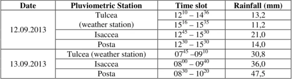
The quantities of precipitation recorded at pluviometric and weather stations in the adjacent area of Flam’s Valley and the sludge pond were (Table 1):
Table 1. The rainfall amount recorded on the 12th and 13th of September in the Flam`s Valley adjacent area
Date Pluviometric Station Time slot Rainfall (mm)
12.09.2013
Tulcea (weather station)
1210 – 1436 13,2 1516 – 1535 11,2
Isaccea 1245 – 1530 21,0
Posta 1230 – 1530 14,0
13.09.2013
Tulcea (weather station) 0745 –0910 30,8
Isaccea 0800 – 0940 36,0
Posta 0830 – 1020 47,5
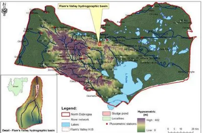
By analyzing the map in Figure 1 it can be noticed that Flam’s Valley basin is located in the adjacent perimeter of the Tulcea weather station and Posta pluviometric station. In these measurement points, the maximum precipitation fell on the 13th of September, respectively 30.8 mm in 1 hour and 25 minutes at Tulcea and 47.5 mm in 1 hour and 50 minutes at Posta.
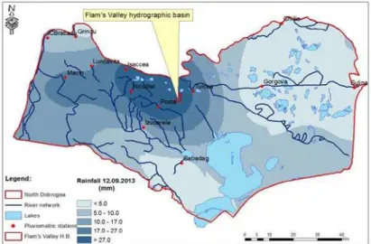
Considering as a maximum amount the rainfall from Posta pluviometric station, resulted a rain intensity of 0.43 mm/min. Judging by the flow values drained on Flam’s Valley it can be said that the rain nucleus from 13 September was situated between Tulcea, Posta and Niculitel, exactly in the basin of study.
Fig. 1. The position of Flam’s Valley basin in Northern Dobrogea
Fig. 2. Spatial distribution of rainfall on the 13th of September 2013 in Northern Dobrogea
Fig. 3. Spatial distribution of rainfall on the 12th of September 2013 in Northern Dobrogea
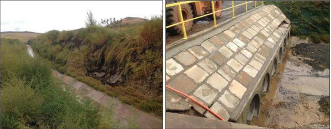
In this context of preliminary wetting of the soil after an earlier rain, the runoff produced in Flam’s Valley area, as a result of exceptional rain produced on the 13th of September has gained disastrous aspects (Figures 4-5).
Fig. 4. Overflow over the bridge on DN 22 Fig. 5. Displaced concrete ditch downstream the red sludge pond
3. ASPECTS REGARDING RUNOFF
Since Flam’s Valley basin isn’t hydrometric controlled, to calculate the corresponding maximum flood flow registered on the 13th of September 2013 there have been made several hydro-topometric lifts on the main drainage channel that borders the west wall of the sludge pond.
continued upward with slopes of earth protected by a textile fabric or geocells on certain sectors.
The channel has slopes covered with abundant herbaceous vegetation (Fig. 6). The channel has a south to north flow direction expanding over a length of about 1200 m until the concrete tubing bridge which facilities the access into the sludge pond perimeter (Fig. 7).
Fig. 6. Herbaceous vegetation on the edges Fig. 7. Bridge over concrete tubing of the channel
On the right side of the channel lies the protective dike of the sludge pond, the left side is open for collecting the surface runoff associated with the corresponding basin surface of the channel.
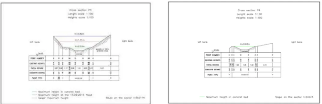
Transverse profiles on the channel (a total of 4 profiles) have sought to identify appropriate levels of drainage into the concrete riverbed at the flood level from 13 September and also the upper level of the channel (Fig. 8).
On a concrete riverbed the drainage has distinct characteristics which required identifying its appropriate level.
The main purpose of making transverse profiles was to identify the appropriate level of the exceptional flood runoff from 13 September and to make hydraulic calculation for the flow. The profiles were raised up to the maximum level of the channel in order to better assess the maximum flow that can transit the channel.
Fig. 8. Transversal sections along Flam’s Valley channel
As a key feature of this channel it may be signaled that in the bridge area located on concrete tubing the channel is reduced in size and its transport capacity diminished and as a consequence the flood water inundated the surrounding area.
Hydraulic calculated flow at the 4 profile sections corresponding to the aforementioned 3 types of levels are shown in Table 2.
When calculating the maximum flow with a 1% flow probability of exceeding it was taken into consideration rain intensity of 1.1 mm/min.
Table 2. Hydraulic calculated flows at the 4 transversal profiles on the main channel
Profile Characteristic levels H*
(m) Ω (m2)
B (m) P (m) R (m) I (‰) V (m/s) Q (m3/s)
P1
H max concrete riverbed 0.53 1.26 3.68 3.95 0.319 0.0038 2.045 2.58
H max on 13 September 2013
flood 1.85 8.97 6.83 8.52 1.053 0.0038 3.814 34
H max channel 3.88 26.09 10.02 13.81 1.889 0.0038 4.102 107
P2
H max concrete riverbed 0.56 1.35 3.73 4.02 0.336 0.0038 2.116 2.86
H max on 13 September 2013
flood 1.79 9.10 7.41 8.73 1.04 0.0038 3.72 34
H max channel 4.91 40.57 12.77 16.97 2.39 0.0038 4.8 194
P3
H max concrete riverbed 0.53 1.25 3.29 3.57 0.35 0.0114 3.77 4.71
H max on 13 September 2013
flood 1.71 8.60 7.56 8.75 0.983 0.0114 5.25 45
H max channel 2.80 18.19 10.04 12.07 1.507 0.0114 5.62 102
P4 H max concrete riverbed 0.63 1.64 3.82 4.13 0.397 0.073 7.26 11.9
Note: H* - water level in the channel in relation to the channel bottom elevation
Ω – section area, B – width section, P – wetted perimeter, R – radius, I – slope, V – water velocity, Q – liquid flow
4. ENVIRONMENTAL IMPACT
Following these repeated torrential rains produced all over Tulcea County, there were houses, annexes and road infrastructures that suffered damages. By Order of the Tulcea Prefect no. 224/17.09.2013 a committee was drawn to better assess the flood damage and the Tulcea County Comitee for Emergency Situations via decision no. 32/23.09.2013 approved the Damage Assessment Report and the reconstruction costs.
According to the report, the following losses caused by weather phenomena manifested during the 12 to 13 September 2013 period were found:
- A total of 22 365 (lm) of street surface was affected, for its recovery is needed 3066.725 thousand lei,
- The roofs of many houses (18) of Frecăţei commune were destroyed -
estimated costs for rebuilding: 98.961 thousand lei,
- A number of 36 household annexes have been destroyed or damaged from
Frecăţei commune - the estimated value of the materials needed to rebuild is
109.118 thousand lei,
- Following a torrent surge a bridge was destroyed in Cataloi village for a length of 10 sqm, and in Baia village a bridge was totally destroyed and other 3 were damaged - estimated costs for rebuilding: 650 thousand lei,
- In Mineri village, due to rapid flooding, a hydrotechnical construction belonging to Somova City Council was damaged - estimated costs for rebuilding: 19.160 thousand lei,
- In the villages near Frecăţei commune a number of 6 wells and 2 water pumps were damaged - estimated costs for rebuilding: 108 thousand lei.
Following this catastrophic event there has been some damage to the arrangements made in Flam’s Valley basin:
- The channels of the main tributaries of Flam’s Valley were clogged by silt that came from upstream and from the slopes to the south for a distance of about 1300 m,
- The slopes of these channels and the main channel present ravines and displacement of soil and of the anti-erosion mat,
- On the western channel, the concrete ditch was dislocated on a stretch of about 15 m by the water torrent. Also dislocation of the concrete ditch of about 30 m in length, have been reported in the main channel (deflection channel),
- The bridge over the channel (installed on concrete tubes) presents some protective plates dislocated,
5. CONCLUSIONS
- The flood from 13 September 2013 on Flam’s Valley was an exceptional flood that produced a peak flow which corresponds to the maximum flow with a 1% flow probability of exceeding.
- Up to the concrete bridge, the channel allowed the maximum flow to transit its surface in good conditions.
- The maximum transport capacity of the channel allows the passage of higher flow rates than those recorded in the flood of 13 September.
- On the lower part of the channel (at the concrete tubing bridge) the flow section is reduced (see profile no. 3), the existence of the bridge preventing a smooth drainage.
- Downstream of the bridge the section is reduced only to a concrete ditch (profile no. 4) which obviously cannot transit the maximum flood flow. Consequently the surrounding area is flooded.
- In the lower sector of the channel the 13 September flood brought a massive silt input from the left part of the basin where it appears that the core of the rain occurred. The above mentioned input and the fact that the concrete ditch couldn’t transit the upstream drainage have led to flooding of the surrounding land.
- Except for the lower sector, affected by the presence of a concrete tubing bridge blocking the drainage, the fast channel performed well in the 13 September flood conditions, evacuating debts collected by Flam’s Valley basin without affecting the red sludge pond.
REFERENCES
1. http://www.mdrap.ro/userfiles/consultari_interministeriale/25_10_13/nf.pdf, December, 16, 2013
2. 671-buletin_hidrometeo_8sept2013, December, 16, 2013
3. http://www.mmediu.ro/beta/wp-content/uploads/2013/09/2013-09-12_Raport-mediu.pdf, December, 16, 2013