1
AFFORESTATION, SUBSEQUENT FOREST FIRES AND PROVISION OF
HYDROLOGICAL SERVICES: A MODEL-BASED ANALYSIS FOR A
MEDITERRANEAN MOUNTAINOUS CATCHMENT
Short title: MEDITERRANEAN AFFORESTATION, FOREST FIRES AND HYDROLOGICAL SERVICES
João Pedro Nunesa,b,c*, Paula Naranjo Quintanillab, Juliana Marisa Santosa,d, Dalila Serpaa, Cláudia Carvalho-Santosa,e, João Rochaa, Jan Jacob Keizera, Saskia Deborah Keesstrab
a) CESAM & Dept. Environment and Planning, University of Aveiro, Portugal b) Wageningen University and Research, Netherlands
c) CE3C: Centre for Ecology, Evolution and Environmental Changes, Faculdade de Ciências, Universidade de Lisboa, Portugal
d) Institute of Geography, Friedrich-Schiller-Universität Jena, Germany e) CIBIO/InBIO, University of Porto, Portugal
*Corresponding author: João Pedro Nunes Email: [email protected]
Phone: +351 217500387 Address:
CE3C, CCIAM
Faculdade de Ciências da Universidade de Lisboa Edifício C1, sala 1.4.39
Campo Grande 1749-016 Lisboa Portugal
Keywords: forest fires, hydrological services, water resources, soil erosion, Mediterranean region
This is the peer reviewed version of the following article:
Nunes J.P., Naranjo Quintanilla P., Santos J.M., Serpa D., Carvalho-Santos C., Rocha J., Keizer J.J., Keesstra S.D. 2018. Afforestation, subsequent forest fires and provision of hydrological services: a model-based analysis for a Mediterranean mountainous catchment. Land Degradation and Development 29 (3): 776-788 (DOI: 10.1002/ldr.2776).
which has been published in final form at https://doi.org/10.1002/ldr.2776. This article may be used for non-commercial purposes in accordance with Wiley Terms and Conditions for Use of
2
Abstract
Mediterranean landscapes have experienced extensive abandonment and reforestation in recent decades, which should have improved the provision of hydrological services such as flood mitigation, soil erosion protection and water quality regulation. However, these forests are fire-prone, and the post-fire increase in runoff, erosion and sediment exports could negatively affect service provision. This issue was assessed using the Soil and Water Assessment Tool model for the Macieira de Alcôba mountain catchment in northwestern Portugal, covered by agriculture and forest plantations, monitored in 2010-2014 and partially burnt in 2011. The model was validated for streamflow, sediment yield and erosion in agricultural fields and burnt hillslopes, showing that it can be adapted for post-fire simulation. Model results for a decadal assessment (2004-2014) show that the fire increased erosion in the burnt slopes from 0.1 to 46.5 Mg ha-1 y-1, and catchment sediment yield from 0.14 to 2.1 Mg ha-1 y-1. Erosion in the burnt forest during this decade was one order of magnitude above that in agricultural fields. Model results for different fire and land-use scenarios indicate that post-fire erosion and sediment yield were lower without post-fire soil management for reforestation, and when the fire occurred in pine forests (land-use before the 1990s) or in shrublands (land-use before afforestation in the 1930s). These impacts were robust to changes in post-fire weather and to a longer (20-year) unburnt period. The results suggest that, in the long term, Mediterranean fire-prone forests might not provide the anticipated soil protection and water quality regulation services.
Introduction
The Mediterranean rim of Europe has experienced extensive land abandonment during the late 20th century, leading to widespread afforestation (Pausas et al., 2008). Afforestation is generally expected to improve the provision of hydrological services, especially flood mitigation, soil erosion protection and water quality regulation, at the expense of decreasing water availability (Bredemeier, 2011; Carvalho-Santos et al., 2014; Keesstra et al., 2009). However, Mediterranean afforestation has also increased the frequency and severity of wildfires (Fernandes et al., 2014; Pausas et al., 2008; Shakesby, 2011), which may potentially increase surface runoff production and soil degradation (Moody et al., 2013; Pausas et al., 2008; Shakesby, 2011) and contaminate streams with toxic compounds in ashes (Bodí et al., 2014; Costa et al., 2014; Verkaik et al., 2013).
Despite this, a clear link between forest fires and hydrological services has yet to be established. While measured post-fire erosion rates are typically lower in the Mediterranean than in other regions, they could still have an important impact on soil degradation due to the generally shallow soils and loss of organic matter (Pausas et al., 2008; Shakesby, 2011; Vieira et al., 2015). It has also been difficult to quantify hydrological and sediment links between burnt hillslopes and streams (Shakesby, 2011; Verkaik et al., 2013), due to a limited understanding of catchment connectivity (Bracken et al., 2015, 2013) and how it is affected by spatial fire severity patterns, soil water repellency, vegetation recovery or post-fire management operations (Moody et al., 2013; Shakesby, 2011).
Studying the relationship between fires and hydrological services has been hampered by a lack of catchment-scale data for Mediterranean burnt areas capable of highlighting long-term erosion rates, hydrological connectivity and sediment transport pathways (Shakesby, 2011). Modelling could provide a tool to overcome these data limitations, but models do not usually account for the impacts of fires on vegetation cover and soil properties (Chen et al., 2013; Moody et al., 2013). However, recent studies have provided solutions, such as fire-adapted algorithms (Nunes et al., 2016c; Vieira et al., 2014) or methods to parameterize post-fire vegetation and soil properties in existing models
3
(Fernández & Vega, 2016; van Eck et al., 2016). Models can now be used to evaluate the specific impacts of wildfires, separating them from post-fire weather or catchment physiographic characteristics (Morrison & Kolden, 2015; Moussoulis et al., 2015), and can therefore establish the long-term impacts of fires on soils and streams in different environments.
The objective of this work was to use a modelling approach to assess the impacts of fires on flood mitigation, soil erosion protection and water quality regulation provided by eucalypt and maritime pine forest plantations in the humid Mediterranean regions of the Iberian Peninsula, considering the pre- and post-fire periods. The Soil and Water Assessment Tool (SWAT) eco-hydrological model (Neitsch et al., 2011) was applied to a representative mountainous watershed in northwestern Portugal, and parameterized using both the results of extensive research into post-fire runoff and erosion processes, and three and a half years of measured data at the hillslope and watershed scale. The model was then used to assess the 10-year impacts of one fire on streamflow, erosion and sediment yield when compared with agriculture, and to explore the relation of these impacts with fire types and land management strategies.
Methods
Study area
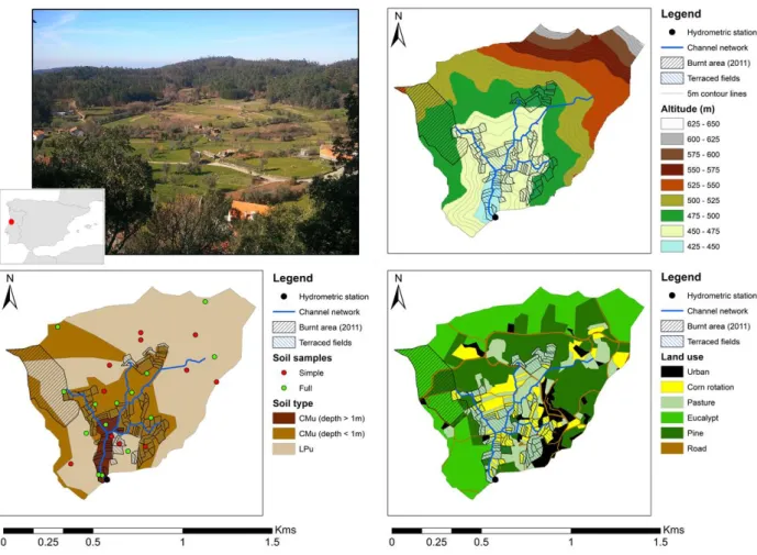
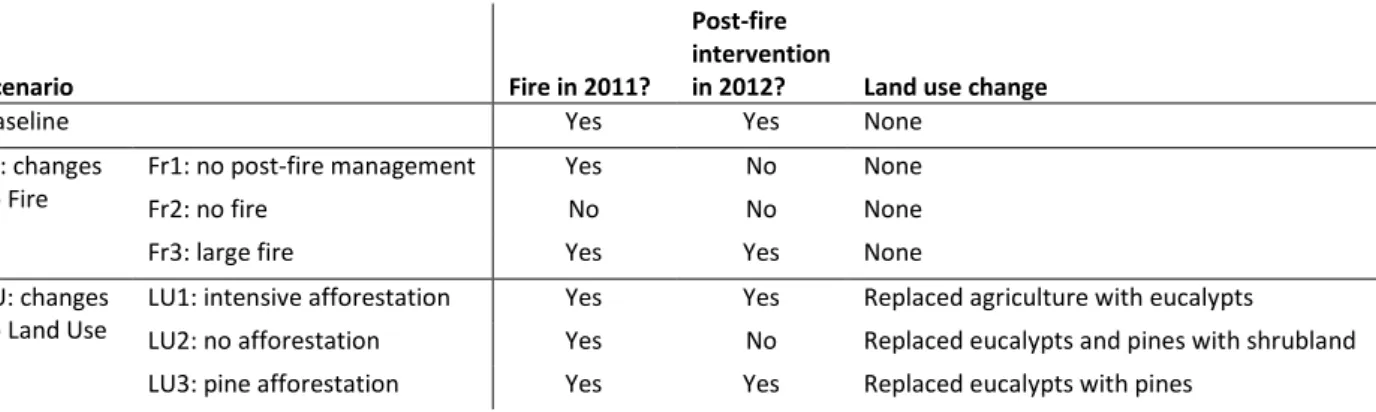
The work was done for the Macieira de Alcôba catchment in northwestern Portugal (Figure 1). It is a headwater catchment located in the Caramulo mountain range, with an altitude of 440-620 m a.s.l. and an area of 94 ha. The climate is humid Mediterranean, with an average annual rainfall of 1294 mm, mostly concentrated in a cold wet season during Autumn and Winter. The watershed overlays a bedrock of granite in the lowlands and schist in the higher slopes. Soils (Figure 1) are generally shallow (40-100 cm) Umbric Leptosols and Humic Cambisols (respectively LPu and CMu; IUSS Working Group WRB, 2015), with a relatively coarse texture; topsoil characteristics are very similar for both soil types, which are differentiated mainly for their depth and the existence of a B horizon in Cambisols. Land use (Figure 1) is a mixture of forest (60%), mainly eucalypt (Eucalyptus globulus) and maritime pine (Pinus
pinaster) plantations in the upper part of the catchment; agriculture (35%), typically permanent
pastures or a rotation between winter pasture and corn in summer (irrigated); and the village of Macieira de Alcôba (5%). About 30% of the agricultural areas are terraced and irrigated during winter to prevent frost, and the terraces are maintained in good conditions by the farmers. The study area is described in detail by Ferreira (1997).
Streamflow is also concentrated during the wet season. The relatively shallow soils and hard bedrock in the Caramulo mountains limit water storage for evapotranspiration in summer (Hawtree et al., 2015; Tavares Wahren et al., 2016). This, associated with the prevalence of water repellent conditions (Santos et al., 2016), leads to a large amount of rainfall percolating from the soil and reaching the streams as lateral flow (Boulet et al., 2015).
Landscape evolution during the 20th century (Ferreira, 1997; Hawtree et al., 2015) was typical of northwestern Iberia. The traditional land use was agriculture in the lowlands, including terraced fields, and shrublands or sparse oak forests in the upper slopes. After the 1930s, the upper slopes were afforested with maritime pine plantations; forest fires started occurring a few decades after, and important areas of the catchment burned in 1969, 1986 and 1991. After the 1991 fire, burnt pine plantations were replaced with eucalypts. A more recent wildfire occurred in August 2011, burning about 10 ha of forest (Figure 1); vegetation and litter conditions after the fire indicated that this was a moderate to severe surface burn (Keeley, 2009). The burnt area was logged and, in March 2012,
4
deep-plowed in preparation for reforestation with eucalypts; 10% of the burnt area was reforested with oaks.
Northwestern Portugal has been the focus of research on hydrological and erosion processes in burnt areas (Ferreira et al., 2008; Malvar et al., 2013, 2016; Shakesby et al., 1996); impacts of post-fire management on hydrological processes and erosion (Martins et al., 2013); post-fire stream water quality (Campos et al., 2012; Ferreira et al., 2016; Silva et al., 2015); hydrological and erosion processes in unburnt forest plantations (Boulet et al., 2015; Hawtree et al., 2015; Santos et al., 2016); and hydrological modelling in burnt and unburnt forests (Nunes et al., 2016c; Rial-Rivas et al., 2011; Tavares Wahren et al., 2016; Vieira et al., 2014). The Macieira watershed has also received some research attention: Ferreira (1997) studied erosion after the 1991 fire, and Nunes et al. (2016a) studied hydrological and erosion processes on terraces. This has helped to conceptualize the hydrological and erosion processes for the different land uses present in this landscape, such as evapotranspiration, soil water retention and repellency, runoff and lateral flow generation, and soil detachment and transport, and to include the impact of fires.
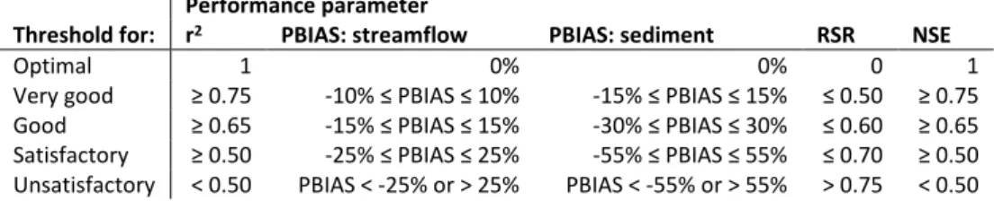
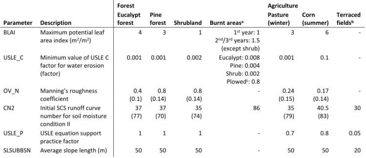
Figure 1. Overview of the watershed from the NE corner and insert with the location in the Iberian Peninsula (upper left), topography of the study area and location of burnt area and terraced fields (upper right), soil distribution and sampling points (lower left) and land use distribution (lower right).
5
Data collection
The watershed was monitored at several scales between 01/11/2010 and 31/03/2014. An automated meteorological station measured rainfall, temperature, relative humidity, solar radiation and wind speed at 15 min intervals. A hydrometric station installed at the watershed outlet (Figure 1) recorded water levels at 2 min intervals between 8/11/2010 and 26/03/2014 using a pressure probe (Campbell Scientific CS450), with streamflow computed using a measured stage-discharge curve. Turbidity was recorded at 2 min intervals between 23/11/2010 and 27/09/2013 using an optical sensor (Campbell Scientific OBS-3+), and sediment concentration was calculated from a laboratory calibration.
Erosion features were characterized by surveys after large rainfall events, i.e. those leasing to what were considered to be important peak streamflow rates in the catchment, following the methodology of Rodríguez-Blanco et al. (2013). Rills and ephemeral gullies were identified and soil loss estimated from the volume of eroded sediments and in-situ samples of topsoil bulk density. 16 surveys were made for agricultural fields between plowing operations in October and June of every year, and 3 surveys were also performed for the burnt area (in 31/05/2012, 17/01/2013 and 14/02/2013); after the last one, however, individual rills and gullies in the burnt area were too eroded to measure, as individual rills merged and rill walls collapsed, making it impossible to distinguish between eroded and uneroded soil.
Topography was interpolated at 5m resolution from the local 1:10,000 topographic map (IGP, 2004). Land use was mapped using aerial photography while field surveys mapped terraced fields, the stream network and, in 2011, the extent of the forest fire. Soil properties were mapped by combining field observations of soil unit distribution with soil samples taken on 25 points (Figure 1). Soil depth, parent material, organic matter content, topsoil bulk density and structure were characterized for all these points; surface random roughness, stone content, texture and saturated hydraulic conductivity (using mini-disks) were measured in 15 of these points; soil water retention at field capacity and wilting point was measured for 10 of these points. Soil properties were averaged to create a typical soil profile for each soil unit. Soil texture and structure were measured in the burnt area after the fire, and were found to be similar to these properties before the fire; therefore, fire impacts on soil properties were not considered.
Model application and evaluation
The Soil and Water Assessment Tool (SWAT) eco-hydrological model (Neitsch et al., 2011) was selected for this work due to its simultaneous representation of hydrology, erosion and vegetation (re-)growth, making it able to represent unburnt forests and agricultural fields, the impacts of fires, and post-fire vegetation recovery. SWAT is a watershed-scale model with a spatial-discretization based on sub-basins, each divided in hydrological response units with unique combinations of land use, soils and slopes. It is applied with daily time-steps and driven by climate and land-use management operations. Relevant simulated processes include vegetation growth, water balance and streamflow routing, soil erosion and sediment transport, and agricultural management practices such as irrigation or seasonal cropping cycles, or disturbances such as forest fires.
SWAT was applied to the study area using meteorological data collected in the watershed from 2011-2014, and in the nearby Pousadas station (5 Km distance) with similar climatic patterns, during 2002-2010. The model was applied for a little over 2 years for spin-up (01/01/2002 to 31/03/2004), and 10 years to produce results (01/04/2004 to 31/03/2014).
6
Model calibration and validation was manual, and performed in three steps:
• An initial parameterization relied heavily on previous SWAT applications to this region, and on existing literature detailing hydrological and erosion processes in burnt forests and terraces. • The model was then calibrated and validated for performance parameters in Table 1 using
daily and monthly data for streamflow (calibration between 8/11/2010 and 30/09/2013, and validation until 26/03/2014) and sediment yield (calibration between 22/11/2010 and 31/01/2013, and validation until 12/10/2013).
• Finally, model results for soil erosion in agricultural fields and burnt forest were validated against data from the erosion surveys, averaged for each land-use type.
Table 1. Model performance thresholds used in this work, for simulations with a monthly time-step, taken from Moriasi et al. (2007) except r2.
Threshold for:
Performance parameter
r2 PBIAS: streamflow PBIAS: sediment RSR NSE
Optimal 1 0% 0% 0 1
Very good ≥ 0.75 -10% ≤ PBIAS ≤ 10% -15% ≤ PBIAS ≤ 15% ≤ 0.50 ≥ 0.75
Good ≥ 0.65 -15% ≤ PBIAS ≤ 15% -30% ≤ PBIAS ≤ 30% ≤ 0.60 ≥ 0.65
Satisfactory ≥ 0.50 -25% ≤ PBIAS ≤ 25% -55% ≤ PBIAS ≤ 55% ≤ 0.70 ≥ 0.50
Unsatisfactory < 0.50 PBIAS < -25% or > 25% PBIAS < -55% or > 55% > 0.75 < 0.50
The initial parameterization was based on previous SWAT applications to the Caramulo mountains (Tavares Wahren et al., 2016) and two nearby headwater forested catchments (Rial-Rivas et al., 2011). Vegetation parameters are shown in Table 2. Those for unburnt eucalypt and pine forests were defined by Nunes et al. (2008). Fires were then introduced using the following steps:
• a fire operation, increasing the runoff generation parameter to simulate the enhanced impacts of soil water repellency in burnt forests (Nunes et al., 2016c), although it was not possible to parameterize seasonal repellency fluctuations;
• fire-affected vegetation, using the vegetation cover from shrubland and increasing the vegetation cover erosion factor using the parameters proposed by Vieira et al. (2014) for eucalypts and pines, which account for the additional soil protection provided by pine needle cast;
• post-fire management, adding a deep plowing operation and no cover in the following dry season;
• post-tillage regrowth with higher vegetation cover (higher Leaf Area Index; van Eck et al., 2016).
Agriculture fields were parameterized using the winter pasture and corn crops in the SWAT database (Arnold et al., 2012) and accounting for tillage, fertilization and irrigation operations following Nunes et al. (2016a). Terraces were characterized by fixing a lower slope length and decreasing the soil conservation factor to simulate a soil retention efficiency of 95% (Nunes et al., 2016b).
Soil and groundwater parameters are shown in Table 3. They were calibrated mostly to take into account the shallow soils, by changing the fraction of the soil profile available for evapotranspiration, and increasing the availability of groundwater for plants (re-evaporation).
The evaluation of SWAT was based on three parameters proposed by Moriasi et al. (2007): the average percent model error (PBIAS), measuring systematic errors; the ratio between the Root of the Mean
7
Squared Error and the standard deviation of observations (RSR), measuring random errors; and the Nash-Sutcliffe Model Efficiency index (NSE), measuring a combination of both. This work added the coefficient of determination (r2), measuring the simulation of data patterns. Table 1 shows the thresholds for model performance used in this work for a monthly time-step simulation; threshold values for r2 were considered similar to NSE due to the similarity between both indices (Beven, 2012). These performance criteria were developed for monthly applications, and criteria for daily applications would probably be less strict (Moriasi et al., 2007).
Table 2. Model parameters for vegetation cover characteristics; when parameters were calibrated, original values from the literature (Nunes et al., 2008; Rial-Rivas et al., 2011; Tavares Wahren et al., 2016) are between parentheses.
Parameter Description
Forest Agriculture
Eucalypt forest
Pine
forest Shrubland Burnt areasa
Pasture (winter) Corn (summer) Terraced fieldsb
BLAI Maximum potential leaf
area index (m2/m2)
4 3 1 1st year: 1
2nd/3rd years: 1.5 (except shrub)
3 6 -
USLE_C Minimum value of USLE C
factor for water erosion (factor) 0.001 0.001 0.002 Eucalypt: 0.008 Pine: 0.004 Shrub: 0.002 Plowedc: 0.8 0.001 0.1 -
OV_N Manning’s roughness
coefficient 0.4 (0.1) 0.8 (0.14) 0.8 (0.14) - 0.24 (0.15) 0.17 (0.14) -
CN2 Initial SCS runoff curve
number for soil moisture condition II 37 (77) 37 (70) 35 (74) 86 35 (79) 40.5 (83) 30
USLE_P USLE equation support
practice factor
1 1 1 - 0.7 0.8 0.05
SLSUBBSN Average slope length (m) 50 50 50 - 50 50 20
a in fire operations, parameter CN2 becomes FIRE_CN2
b in terracing operations, parameters CN2, USLE_P and SLSUBBSN become TERR_CN2, TERR_P and TERR_SL, respectively c calculated by SWAT for bare soils
Table 3. Model parameters for soil and groundwater characteristics; when parameters were calibrated, original values (SWAT default database or ) are between parentheses.
Parameter Description Calibrated value
ESCO Soil evaporation compensation factor 0.01 (0.95)
EPCO Plant uptake compensation factor 0 (1)
DEP_IMP Depth to impervious layer (mm) 3000
DIS_STREAM Average distance to stream (m) 0 (35)
ALPHA_BF Baseflow alpha factor 0.048
GWQMIN Threshold depth of water in the shallow
aquifer required for return flow to occur (mm)
1000
GW_REVAP Groundwater re-evaporation coefficient Forest: 0.15 (0.02)
Agriculture: 0.2 (0.02) REVAPMN Threshold depth of water in the shallow
aquifer for re-evaporation to occur (mm)
0 (750)
8
Land-use scenarios and hydrological services evaluation
The calibrated SWAT was then used to assess the impacts on flood mitigation, soil erosion protection and water quality regulation, of different fire and land-use scenarios (summarized in Table 4):
• Baseline: observed situation. Fire in 2011 with post-fire management. • Scenario family Fr: changes to fire properties and management.
o Scenario Fr1: no post-fire management. Assumes that areas burnt in 2011 were left for natural regeneration, simulating what happened after the 1969 fire.
o Scenario Fr2: no fire. Assumes that the 2011 fire did not occur.
o Scenario Fr3: large fire. Assumes that the 2011 fire burned both the forest and agriculture areas (assuming similar fire effects on forest and agricultural soils), simulating what happened in 2012 and 2016 to much of the Caramulo mountains. • Scenario family LU: changes to land-use.
o Scenario LU1: intensive afforestation. Assumes that the entire catchment was forested with eucalypts, simulating the present-day condition of most of the
surrounding headwater catchments; and that a proportionally higher area burned in 2011.
o Scenario LU2: no afforestation. Assumes that natural growing shrublands occupied the hillslopes, simulating the situation before afforestation in the 1930s; and that the 2011 fire burned shrublands.
o Scenario LU3: pine afforestation. Assumes that afforestation occurred with pine only, simulating the situation between the 1930s and the 1980s; and that the 2011 fire burned pine stands.
Table 4. Characteristics of the different scenarios used in this work.
Scenario Fire in 2011?
Post-fire intervention
in 2012? Land use change
Baseline Yes Yes None
Fr: changes to Fire
Fr1: no post-fire management Yes No None
Fr2: no fire No No None
Fr3: large fire Yes Yes None
LU: changes to Land Use
LU1: intensive afforestation Yes Yes Replaced agriculture with eucalypts
LU2: no afforestation Yes No Replaced eucalypts and pines with shrubland
LU3: pine afforestation Yes Yes Replaced eucalypts with pines
The scenarios were implemented by either changing fire occurrence and/or post-fire plowing in each land-use, or by changing the vegetation in different parts of the catchment, according to the scenario rules shown in Table 4. A new vegetation class was added for scenario LU2 to represent shrublands, with parameters taken from the garrigue class in the SWAT database (Arnold et al., 2012) and shown in Table 2. The model was then run for a 10-year period between 01/01/2004 and 31/03/2014 with a monthly time step, and results were compared with the baseline run. Three hydrological services were assessed:
• flood mitigation was assessed through the surface runoff component of the stream hydrograph;
9
• soil erosion protection was assessed by comparing simulated erosion rates with long-term tolerable soil loss rates (Verheijen et al., 2012);
• water quality regulation was assessed through sediment yield, used as a proxy for exports of ashes and nutrients (Campos et al., 2012; Faria et al., 2015; Silva et al., 2015).
Results
Model performance
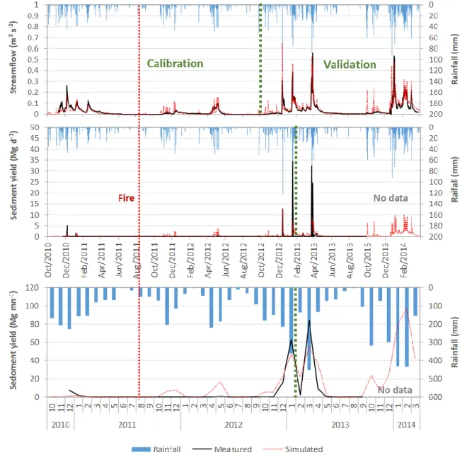
Table 5 shows SWAT model performance for streamflow and sediment yield measured at the catchment outlet. The streamflow simulation could be considered satisfactory at the daily scale (but very good for PBIAS), and very good at the monthly scale. Most of the model errors involved the excessively fast wetting of the catchment after each dry season (Figure 2). Tavares Wahren et al. (2016) found similar difficulties with SWAT in this region, and pointed to possible limitations in simulating litter layer interception and soil water repellency shifts between the dry and wet seasons.
Table 5. Performance statistics for the SWAT application to Macieira, for the parameters shown in Table 1.
Streamflow Sediment yield Parameter Daily Monthly Daily Monthly
r2 0.64 0.90 0.15 0.75
PBIAS 8.3% 6.2% 30.0% 30.0%
RSR 0.66 0.33 0.92 0.51
NSE 0.57 0.89 0.15 0.74
The sediment yield simulation could be considered good at the monthly scale (with very good r2), but not satisfactory at the daily scale (except for a good PBIAS), as shown in Table 5. This is mostly due to the incorrect simulation of within-channel sediment dynamics; measured sediment yield after storms was usually quicker than SWAT simulations (Figure 2). SWAT performance at the monthly scale (Figure 2) followed the general trend and magnitude of sediment yield during the calibration and validation period, although overestimating it for the wet season of 2011/2012.
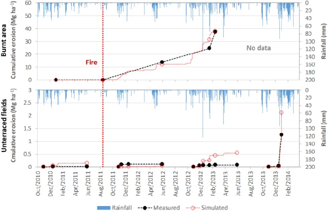
Figure 3 shows model validation results for field-scale erosion. SWAT could adequately simulate erosion in both agricultural fields and the burnt area, clearly distinguishing both, although erosion was overestimated in 2012/2013 due to difficulties in simulating winter pasture growth. This adequate field-scale performance also indicated that the model was able to correctly assign the sources of sediment delivered to streams.
Baseline for water and sediment processes
Model results indicated that the impact of the 2011 fire on water processes was small, as most of the variability in streamflow could be attributed to similar changes in rainfall, as visible when comparing annual rainfall and runoff (Figure 4). However, results did indicate a large impact on erosion rates (Table 6). Erosion in unburnt forests was generally low, and 1-2 orders of magnitude lower than in agricultural fields. Fires raised erosion rates in eucalypts by a factor of 439 compared with pre-fire rates, but only 2.2 in pines due to the protection given by the needle cast cover. Post-fire plowing raised erosion in the 2nd year by a factor of 1135 and 295 over pre-fire rates, respectively. Erosion in
10
the 3rd year was similar in eucalypts but higher in pines (716 times); while higher rainfall increased runoff and erosion in pines, the faster re-growth of eucalypts compensated for this increase with higher infiltration and cover. Nevertheless, higher erosion resulted in sediment yield increasing 14.2 times over pre-fire years, from 0.14 to 2.1 Mg ha-1 y-1 (also indicated by the sediment yield data in Figure 2).
Figure 2. Measured and simulated values (baseline scenario) for daily streamflow (top), daily sediment yield (mid) and monthly sediment yield (bottom); the green line separates between calibration and validation periods, and the red line indicates the date of the fire. Note the absence of sediment data from mid-October 2013 onward.
11
Figure 3. Measured and simulated values for cumulative erosion in the burnt area (top) and unterraced fields (bottom); the red line indicates the date of the fire. Intervals between different accumulation periods in the fields were not measured.
Table 6. Erosion rates during the simulation period (2004-2014), and for specific points in time, for different land uses in Macieira. Values are taken both from the baseline run and, when noted, from one of the scenarios detailed in Table 4.
Land use Erosion (Mg ha-1 yr-1) Average 2004/2014 Before fire 1st year after fire 2nd year after fire 3rd year after fire a Early pasture Late pasture Corn plantation Eucalypt Unburnt 0.1 - - - - Burnt, plowed b 14.0 0.1 23.5 60.8 55.3 - - - Burnt, unmanaged c 8.2 0.1 19.7 10.0 52.1 - - - Pine Unburnt 0.02 - - - - Burnt, plowed b 5.9 0.1 0.1 17.2 41.7 - - - Burnt, unmanaged c 3.8 0.1 0.1 1.1 35.9 - - - Pasture Normal 0.6 - - - - Terraced 0.03 - - - - Corn rotation Normal 0.9 - - - - 0.6 0.3 0.0 Terraced 0.02 - - - - 0.01 0.01 0.00 Urban 0.2 - - - - Shrubland Unburnt c 1.3 - - - - - - - Burnt, unmanaged c 2.4 0.1 2.0 9.2 11.8 - - -
a calculated using model results for the first 8 months, and assuming negligible erosion in the following 4 months (dry season)
b plowed 6 months after the fire c values from scenario
12
Figure 4. Relationship between annual rainfall and runoff, before and after the fire. Annual values were calculated between September and august of the following year; values for the 3rd year after fire were calculated using model results for the
first 8 months and assuming negligible rainfall and runoff in the remainder (dry season).
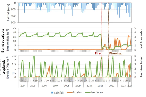
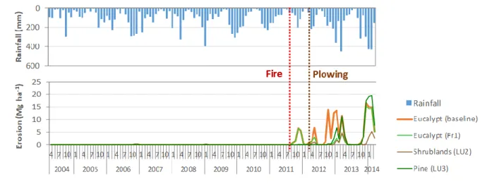
Figure 5. Monthly rainfall (top) and comparison between simulated monthly erosion rates and vegetation cover (Leaf Area Index) for burnt eucalypts (mid) and unterraced croplands with pasture/corn rotation (bottom) for the 10-year simulation period; the red and brown lines indicate the dates of the fire and plowing, respectively.
Erosion in agricultural fields and burnt areas followed different temporal patterns (Figure 5). 95% of erosion in agricultural fields occurred in the wet season period between October and January, due to a combination of large rainfall events and low soil cover during the early stages of pasture development; later rainfall, including the wet season period between late winter and early spring (February to April), only led to about 5% of erosion. In contrast, erosion in burnt areas depended only on the occurrence of rainfall events regardless of the period, and therefore erosive episodes happened more frequently. Erosion in unburnt forests was negligible due to the high vegetation cover
13
throughout the year, which despite the small seasonal variation of foliage (Whitehead & Beadle, 2004) did not decrease to the point of leaving the soils unprotected.
Thanks to the fire, forest erosion rates during the entire decade, including unburnt and burnt years, were higher than those in unterraced agricultural fields with pasture/corn rotation by a factor of 16 in eucalypts and 7 in pines. During this decade, 93% of sediments originated from the burnt areas during a short 2.5-year period of fire vegetation disturbance. Both observed and simulated post-fire erosion rates (Table 6, Figure 3 and Figure 5) were above typical values in Mediterranean regions, of 1-10 Mg ha-1 yr-1, although these can increase by one order of magnitude with post-fire management (Pausas et al., 2008; Shakesby, 2011). One likely explanation is that this is a consequence of scale: most studies focus on small plots (including Ferreira, 1997), while this study included hillslopes with rill formation where higher erosion rates are expected (de Vente & Poesen, 2005).
Scenario results
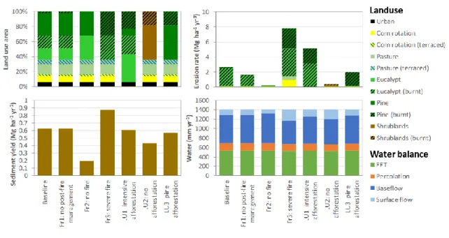
The land-use distribution in each scenario and results for erosion, sediment yield and water balance are shown in Figure 6. As described in Table 4, all scenarios were affected by fire except Fr2.
Figure 6. Land use distribution (upper left), catchment erosion rate and importance of each land use for erosion (upper right), sediment yield (lower left), and distribution of water flows from the catchment (lower right), for each scenario listed in Table 4. All values except land use distribution are annual averages for the 10-year period over the entire catchment.
For water balance, effective evapotranspiration (EET) and percolation were constant for all scenarios; the main differences were on the surface flow fraction of streamflow, which increased in scenarios with larger burnt areas. In fact, the baseline and scenarios with forest and similarly sized fires (Fr1 and LU3) led to surface flow fractions of 16-18% (Figure 6), not much higher than the 12% of the no-fire scenario (Fr2). The scenario with a similar fire but shrubland (LU2) led to an intermediate increase of 22%; and the highest increases in surface flow fractions were to 28-33%, in the scenarios with the most widespread fires (Fr3 and LU1).
14
Figure 6 also shows that erosion in burnt areas represented most of the erosion during the 10-year period in most scenarios with fire (89-96%), except for the shrubland scenario (LU2; 41%). This was despite the relatively short disturbance period (2.5 years in 10) and small size of the fire, at least in the baseline and scenarios Fr1, LU2 and LU3 (19% of the catchment area; see Figure 6). Thus, the no fire scenario (Fr2) had the lowest erosion rates.
The shrubland scenario (LU2) had the second lowest erosion rates, due to the small effect of fire on shrubland erosion when compared with eucalypt and pine (Table 6). Similarly smaller impacts of fires on shrublands were observed by Cerdà & Lasanta (2005) for an area with similar climate, with post-fire erosion rates of 0.1-0.6 Mg ha-1 yr-1, resulting only in an increase from control conditions by a factor of 2 to 4.5. In this scenario, erosion also increased by one order of magnitude in unburnt shrublands during the 2013/2014 wet winter.
Of the remaining forest scenarios (Figure 6), the elimination of post-fire management (Fr1) led to a decrease in erosion of -38%, which could be expected from observations in intervened burnt areas (Martins et al., 2013). The afforestation with pine (LU3) led to -26% erosion, due to the protective soil cover of needle cast in burnt pines (Shakesby et al., 1996; Vieira et al., 2014). And the scenarios with the highest burnt area (Fr3 and LU1, with 100 and 48%) also had the highest erosion rates.
Figure 7. Monthly rainfall (top) and comparison between simulated monthly erosion rates for burnt forest and shrubland cover in different scenarios (bottom) for the 10-year simulation period; the red and brown lines indicate the dates of the fire and plowing, respectively.
Figure 7 shows the monthly evolution of erosion rates in the burnt areas for the different scenarios. Three distinct periods can be seen:
• In the wet season after the fire (September 2011 to March 2012), erosion is only important in the burnt eucalypts (baseline and Fr1); rainfall is not sufficient to cause strong erosion in shrublands (due to lower destruction of soil cover; LU2) and pines (due to pine needle cover; LU3).
• In the dry and wet seasons after plowing (April 2012 to April 2013), erosion is mostly
15
erosion than in unplowed eucalypts (Fr1), which was also observed by Shakesby et al. (1996).
• After the plowing, new vegetation grows but the following wet season (from October 2013) leads to strong rainfall, and equivalent erosion in all landcovers except shrubland; the model simulates this also taking into account the low accumulation of residue over soils. This highlights the role of extreme rainfall events, which led to higher erosion rates than those observed for bare soils in the previous period.
Sediment yield had a similar behavior to that of erosion, but with noticeably smaller differences between scenarios (Figure 6). This was especially the case for the scenarios Fr3 and LU1, with much higher erosion rates but negligible to moderate increases in sediment yield over the baseline. This can be attributed to a limited capacity of the watershed to export all eroded sediment, with the remainder being deposited before reaching the stream network. In any case, all fire scenarios showed an increase of sediment yield by a factor of 2.1 to 3.6 over the no fire scenario.
Discussion
Impacts on forest hydrological services
The results of this study indicate that forest fires had a moderate impact on flood mitigation, increasing the surface runoff fraction but not total streamflow (Figure 6). This lack of relationship between vegetation cover and water balance has been studied in this region. Hawtree et al. (2015) found that the afforestation of this region in the 20th century did not have a significant impact on total streamflow; modelling studies using SWAT have highlighted the role of shallow soils for this process (Carvalho-Santos et al., 2016; Tavares Wahren et al., 2016). The authors point to the low soil water capacity, limiting soil water storage in the rainy season and consequently soil water availability for evapotranspiration in the dry season; and to the shallow soil depths and hard bedrock, preventing tree roots from take advantage of deeper water sources. The low planting density, caused by the poor soils, also limits interception and transpiration even in mature forest stands (Hawtree et al., 2015; van Eck et al., 2016).
Nevertheless, this moderate impact can still negatively affect the benefits provided by afforestation for flood mitigation. Hawtree et al. (2015) also found that afforestation with eucalypts in this region led to a slight increase of surface flow, although without distinguishing the impacts of fires from others such as soil water repellency or terrace collapse. Moreover, these moderate impacts could be concentrated during the larger floods and have disproportionately severe impacts on peak flows (Papathanasiou et al., 2015).
In contrast, results indicate that forest fires had a large impact on soil erosion protection, leading to long-term erosion rates one order of magnitude higher than the tolerable soil erosion rate of 1 Mg ha -1 yr-1 (Verheijen et al., 2012). Not only was the service negated, but afforestation followed by fire led to higher erosion rates than those in the agricultural fields and shrublands they replaced, which experienced erosion similar to or under tolerable rates (Table 6). These impacts could be mitigated by replacing eucalypts with pines or native (and less fire-prone) species, namely deciduous and evergreen oaks; or with less disturbances by post-fire management (Table 6). They would also depend on the probability of fire occurrence and weather during the post-fire disturbance window, but these parameters were not explicitly tested.
16
Finally, forest fires also had an impact on water quality regulation, but smaller than that on soil erosion protection. It is difficult to evaluate the impacts of fires on water quality since the links between fire-related contamination and ecological impacts are not yet well established (Verkaik et al., 2013). However, while agricultural areas have relatively constant exports of nutrients when compared to forests (see Carvalho-Santos et al., 2016), forests might experience infrequent but higher magnitude problems related with the sudden post-fire exports of nutrients, polycyclic aromatic hydrocarbons or metals (Bodí et al., 2014; Verkaik et al., 2013). This issue merits further research.
It should be noted that these results are for a moderate to severe surface burnt, and burn severity has a strong impact on erosion (Vieira et al., 2015); other types of fire could lead to lesser or stronger impacts.
Hydrological services and forest fire recurrence
The recurrence period of forest fires plays an important role on the magnitude of these impacts on hydrological services. Many forest plantations in this region are affected by repeated fires; of the recent fires in Macieira in 1969, 1986, 1991 and 2011, the two latter affected the same part of the watershed (where this study was focused) and therefore the recent fire recurrence was about 20 years. This is similar to the average forest fire recurrence in Portugal, of about 24 years (Cardoso Pereira et al., 2006); but fire recurrence varies greatly with climate, topography, planted species and human intervention (Nunes et al., 2016a; Silva et al., 2009), so these impacts will vary greatly as well. Given this, the present 10-year period could be rather short to properly assess the long-term impacts of single fires. Moreover, the post-fire weather might not be representative; the weather immediately after the fire was especially dry, but the winter of 2013/2014 was especially wet, leading to high erosion rates even in the agricultural fields (Figure 3). Nonetheless, these erosion rates can provide an indication of soil erosion protection (and, hence, sediment yield and water quality regulation), for longer periods and different post-fire weather conditions. Extrapolating the model results for the period from 1994 to 2014 (by considering the same erosion rate in all the pre-fire period), long-term erosion rates in eucalypts would drop from 14 to 7 Mg ha-1 yr-1 but still be one order of magnitude above agricultural and tolerable rates. Even when further extrapolating results for this 20-year period by considering drier rainfall conditions after the fire and no post-fire management (by using only erosion rates for the 1st post-fire year in Table 6 to represent erosion from 2011 to 2014), long-term erosion rates in eucalypts would be 3 Mg ha-1 yr-1, still above the tolerable threshold. These considerations indicate that the present conclusions are robust and largely independent of the selected analysis period.
It should be noted that Macieira is a relatively small watershed, and the conclusions on water quality regulation might not hold for larger areas. The Águeda river basin in the Caramulo mountains (404 Km2) has been affected by several large fires (burning more than 5% of the watershed) in 1985, 1986, 1991, 1995, 2005, 2013 and 2015 (Hawtree et al., 2015). These fires affected different sub-basins, but it is possible that all of them had important effects in the river water quality, pointing to a much shorter return period for this disturbance of about 5 years. This issue requires further research, which can be conducted for larger areas using the approach described in this work.
Implications for forest management
Forest plantations cause their own disturbances. Eucalypt and pine plantations are short rotation trees with frequent harvests: every 8-12 years for eucalypts and every 35-50 years or pines. Harvesting also
17
creates a disturbance, depending on the type: thinning, clear cutting and replanting, cutting and natural re-sprouting (in eucalypts), etc. However, fires can be considered to have a larger impact. The increase in the effect of soil water repellency when compared with unburnt plantations (Nunes et al., 2016c) can lead to increased runoff and erosion (Malvar et al., 2016). Also, fires can lead to subsequent disturbances such as salvage logging and replanting, as happened in Macieira, which can add to the impacts of the fire itself (Martins et al., 2013). And finally, fires have the added impact of the deposition and export of ash, with the additional potential for streamflow contamination with toxic substances (Bodí et al., 2014; Verkaik et al., 2013).
Forest managers can address this issue in two ways, as discussed in length by Ferreira et al. (2015). Immediate post-fire action can be used to protect soils from erosion, with techniques such as mulching, seeding and re-vegetation, or infiltration promotion treatments; or to limit sediment transport to the stream network with hillslope or channel barriers. However, these are mitigating measures, and more recent thinking has focused on methods to prevent fires in these landscapes: fuel management techniques, such as grazing or prescribed fires, or landscape management methods combining plantations with less fire-prone species such as oaks. In the latter case, less fire-prone vegetation can also be planted to limit sediment connectivity (Bracken et al., 2015) and further protect streams. In this respect, it should be noted that part of the Macieira burnt area was reforested with oak; while it was not possible to simulate this in this work as parameters for the post-fire plantation were not considered reliable, this is an option which other landowners might consider in the future, and therefore merits further attention.
Overall, the results of this study indicate that the hydrological services provided by forests (Carvalho-Santos et al., 2014) can be limited by fire occurrence. This is especially important when evaluating the results of afforestation with eucalypts and pines, since these forests are especially fire-prone when compared with other fire types (Silva et al., 2009) and given the role of human-induced land-use changes on fire occurrence (Fernandes et al., 2014). These findings are also relevant for other regions where forest plantations have replaced native ecosystems which are fire adapted, and therefore are vulnerable to similar forest fire disturbances, such as the rest of the Mediterranean (e.g. Spain), transitional humid-dry regions in the Americas (Argentina, Chile, Southwestern US), southern Africa and Australia (Garcia-Chevesich et al., 2017). Further work should test these findings for different areas and post-fire conditions, and to consider the probability of fire occurrence when assessing long-term impacts.
Conclusions
The application of the SWAT model to the Macieira catchment highlighted how, in humid Mediterranean mountain regions, the hydrological services of soil erosion protection and water quality regulation provided by forests might be negatively affected by fire occurrence. These results are especially relevant for fire-prone species such as eucalypts and pines. The application to the observed situation with a fire in 2011 indicated that:
• the SWAT model can be successfully adapted to simulate post-fire conditions in this region; • fire impacts on streamflow were difficult to determine, as it mostly followed rainfall
variability;
• soil erosion in the burnt areas increased by 3 orders of magnitude, which also increased sediment yield (and hence decreased water quality);
18
• the fire led to erosion rates in forests higher than those in agricultural fields by an order of magnitude, even when considering a 10-year period with 7.5 years of unburnt forest; • most soil loss during this period occurred inside the burnt areas.
The model-based analysis of different land use and fire scenarios showed that, in this region: • fires may affect the surface runoff fraction, which might lead to a small increase in peak
flood rates, but have negligible impacts on total streamflow;
• forest fires have a strong impact on erosion, higher for larger burnt areas, while fires in shrublands have a smaller but still important impact;
• reducing the impacts of post-fire soil management or replacing eucalypts with pines can decrease post-fire erosion rates;
• fire impacts on sediment yield (and hence water quality) are similar to those on erosion, but with lower magnitude, as an important part of eroded sediments redeposits before reaching the stream network.
Further work is necessary to better assess the role of fire probability, frequency, size, and post-fire weather on the disruption of forest hydrological services; and on the specific characteristics of fire impacts on water quality, which will differ from those of agriculture in contaminants by being low-frequency, high-magnitude events.
Acknowledgements
This work was funded by the Portuguese Foundation for Science and Technology within the framework of project ERLAND: “Direct and indirect impacts of climate change on soil erosion and land degradation in Mediterranean watersheds” (FCOMP-01-0124-FEDER-008534), the research grants attributed to J.P. Nunes (SFRH/BPD/39721/2007, SFRH/BPD/87571/2012 and IF/00586/2015) and D. Serpa (SFRH/BPD/92650/2013), and funding for the CESAM centre (UID/AMB/50017), co-funded by the European Social Fund and the European Regional Development Fund within the PT2020 Partnership Agreement and Compete 2020. Additional funding was granted through COST (European Cooperation in Science and Technology) under Action ES1306 “Connecting European Connectivity Research”.
References
Arnold JG, Kiniry JR, Srinivasan R, Williams JR, Haney EB, Neitsch SL. 2012. Soil & Water Assessment
Tool Input/Output documentation, version 2012 (TR-438). College Station: Texas Water Resources
Institute.
Beven KJ. 2012. Rainfall-Runoff Modelling: The Primer (2nd ed.). Hoboken: Wiley-Blackwell. Bodí MB, Martin DA, Balfour VN, Santín C, Doerr SH, Pereira P, Cerdà A, Mataix-Solera J. 2014. Wildland fire ash: Production, composition and eco-hydro-geomorphic effects. Earth-Science
Reviews 130: 103–127. DOI: 10.1016/j.earscirev.2013.12.007
Boulet A-K, Prats SA, Malvar MC, González-Pelayo O, Coelho COA, Ferreira AJD, Keizer JJ. 2015. Surface and subsurface flow in eucalyptus plantations in north-central Portugal. Journal of Hydrology
and Hydromechanics 63: 193–200. DOI: 10.1515/johh-2015-0015
Bracken LJ, Turnbull L, Wainwright J, Bogaart P. 2015. Sediment connectivity: a framework for understanding sediment transfer at multiple scales. Earth Surface Processes and Landforms 40: 177–
19 188. DOI: 10.1002/esp.3635
Bracken LJ, Wainwright J, Ali GA, Tetzlaff D, Smith MW, Reaney SM, Roy AG. 2013. Concepts of hydrological connectivity: Research approaches, pathways and future agendas. Earth Science
Reviews 119: 17–34. DOI: 10.1016/j.earscirev.2013.02.001
Bredemeier M. 2011. Forest, climate and water issues in Europe. Ecohydrology 4: 159–167. DOI: 10.1002/eco.203
Campos I, Abrantes N, Vidal T, Bastos AC, Gonçalves F, Keizer JJ. 2012. Assessment of the toxicity of ash-loaded runoff from a recently burnt eucalypt plantation. European Journal of Forest Research
131: 1889–1903. DOI: 10.1007/s10342-012-0640-7
Cardoso Pereira JM, Brito Carreiras JM, Neves Silva JM, Vasconcelos MJ. 2006. Alguns conceitos básicos sobre os fogos rurais em Portugal. In J. S. Pereira, J. M. Cardoso Pereira, F. Castro Rego, J. M. N. Silva & T. Pereira da Silva (Eds.), Incêndios Florestais em Portugal. Caracterização, Impactes e
Prevenção (pp. 133–161). Lisbon: ISAPress.
Carvalho-Santos C, Honrado JP, Hein L. 2014. Hydrological services and the role of forests: Conceptualization and indicator-based analysis with an illustration at a regional scale. Ecological
Complexity 20: 69–80. DOI: 10.1016/j.ecocom.2014.09.001
Carvalho-Santos C, Nunes JP, Monteiro AT, Hein L, Honrado JP. 2016. Assessing the effects of land cover and future climate conditions on the provision of hydrological services in a medium-sized watershed of Portugal. Hydrological Processes 30: 720–738. DOI: 10.1002/hyp.10621
Cerdà A, Lasanta T. 2005. Long-term erosional responses after fire in the Central Spanish Pyrenees: 1. Water and sediment yield. Catena 60: 59–80. DOI: 10.1016/j.catena.2004.09.006
Chen L, Berli M, Chief K. 2013. Examining modeling approaches for the rainfall-runoff process in wildfire-affected watersheds: Using San Dimas Experimental Forest. Journal of the American Water
Resources Association 49: 851–866. DOI: 10.1111/jawr.12043
Costa MR, Calvão AR, Aranha J. 2014. Linking wildfire effects on soil and water chemistry of the Marão River watershed, Portugal, and biomass changes detected from Landsat imagery. Applied
Geochemistry 44: 93–102. DOI: 10.1016/j.apgeochem.2013.09.009
de Vente J, Poesen J. 2005. Predicting soil erosion and sediment yield at the basin scale: Scale issues and semi-quantitative models. Earth-Science Reviews 71: 95–125. DOI:
10.1016/j.earscirev.2005.02.002
Faria SR, De la Rosa JM, Knicker H, González-Pérez JA, Keizer JJ. 2015. Molecular characterization of wildfire impacts on organic matter in eroded sediments and topsoil in Mediterranean eucalypt stands. Catena 135: 29–37. DOI: 10.1016/j.catena.2015.07.007
Fernandes PM, Loureiro C, Guiomar N, Pezzatti GB, Manso FT, Lopes L. 2014. The dynamics and drivers of fuel and fire in the Portuguese public forest. Journal of Environmental Management 146: 373–382. DOI: 10.1016/j.jenvman.2014.07.049
Fernández C, Vega JA. 2016. Evaluation of RUSLE and PESERA models for predicting soil erosion losses in the first year after wildfire in NW Spain. Geoderma 273: 64–72. DOI:
10.1016/j.geoderma.2016.03.016
Ferreira AJD, Coelho COA, Ritsema CJ, Boulet AK, Keizer JJ. 2008. Soil and water degradation processes in burned areas: lessons learned from a nested approach. Catena 74: 273–285. DOI: 10.1016/j.catena.2008.05.007
20
2015. Strategies to prevent forest fires and techniques to reverse degradation processes in burned areas. Catena 128: 224–237. DOI: 10.1016/j.catena.2014.09.002
Ferreira CG. 1997. Erosão hídrica em solos florestais. Estudo em povoamentos de Pinus Pinaster e Eucalyptus Globulus em Macieira de Alcôba - Águeda. Revista Da Faculdade de Letras Da
Universidade Do Porto - Geografia I Série XII/XIII: 145–244.
Ferreira RV, Serpa D, Cerqueira MA, Keizer JJ. 2016. Short-time phosphorus losses by overland flow in burnt pine and eucalypt plantations in north-central Portugal: A study at micro-plot scale. Science
of the Total Environment 551–552: 631–639. DOI: 10.1016/j.scitotenv.2016.02.036
Garcia-Chevesich PA, Neary DG, Scott DF, Benyon RG, Reyna T (Eds.). 2017. Forest Management and
the impact on water resources: a review of 13 countries. IHP - VIII / Technical document No 37.
Montevideo: UNESCO: United Nations Educational, Scientific and Cultural Organization.
Hawtree D, Nunes JP, Keizer JJ, Jacinto R, Santos J, Rial-Rivas ME, Boulet AK, Tavares-Wahren F, Feger KH. 2015. Time series analysis of the long-term hydrologic impacts of afforestation in the Águeda watershed of north-central Portugal. Hydrology and Earth System Sciences 19: 3033–3045. DOI: 10.5194/hess-19-3033-2015
IGP. 2004. Carta Topográfica na escala 1: 10 000. Lisbon: Instituto Geográfico Português (IGP). IUSS Working Group WRB. 2015. World reference base for soil resources 2014, update 2015.
International soil classification system for naming soils and creating legends for soil maps. Rome.
Keeley JE. 2009. Fire intensity, fire severity and burn severity: A brief review and suggested usage.
International Journal of Wildland Fire 18: 116–126. DOI: 10.1071/WF07049
Keesstra SD, van Dam O, Verstraeten G, van Huissteden J. 2009. Changing sediment dynamics due to natural reforestation in the Dragonja catchment, SW Slovenia. Catena 78: 60–71. DOI:
10.1016/j.catena.2009.02.021
Malvar MC, Martins MAS, Nunes JP, Robichaud PR, Keizer JJ. 2013. Assessing the role of pre-fire ground preparation operations and soil water repellency in post-fire runoff and inter-rill erosion by repeated rainfall simulation experiments in Portuguese eucalypt plantations. Catena 108: 69–83. DOI: 10.1016/j.catena.2012.11.004
Malvar MC, Prats SA, Nunes JP, Keizer JJ. 2016. Soil water repellency severity and its spatio-temporal variation in burnt eucalypt plantations in north-central Portugal. Land Degradation & Development
27: 1463–1478. DOI: 10.1002/ldr.2450
Martins MAS, Machado AI, Serpa D, Prats SA, Faria SR, Varela MET, González-Pelayo Ó, Keizer JJ. 2013. Runoff and inter-rill erosion in a Maritime Pine and a Eucalypt plantation following wildfire and terracing in north-central Portugal. Journal of Hydrology and Hydromechanics 61: 261–268. DOI: 10.2478/johh-2013-0033
Moody JA, Shakesby RA, Robichaud PR, Cannon SH, Martin DA. 2013. Current research issues related to post-wildfire runoff and erosion processes. Earth-Science Reviews 122: 10–37. DOI:
10.1016/j.earscirev.2013.03.004
Moriasi DN, Arnold JG, Van Liew MW, Bingner RL, Harmel RD, Veith TL. 2007. Model evaluation guidelines for systematic quantification of accuracy in watershed simulations. Transactions of the
ASABE 50: 885–900. DOI: 10.13031/2013.23153
Morrison KD, Kolden CA. 2015. Modeling the impacts of wildfire on runoff and pollutant transport from coastal watersheds to the nearshore environment. Journal of Environmental Management 151: 113–123. DOI: 10.1016/j.jenvman.2014.12.025
21
Moussoulis E, Mallinis G, Koutsias N, Zacharias I. 2015. Modelling surface runoff to evaluate the effects of wildfires in multiple semi-arid, shrubland-dominated catchments. Hydrological Processes
29: 4427–4441. DOI: 10.1002/hyp.10509
Neitsch SL, Arnold JG, Kiniry JR, Williams JR. 2011. Soil and Water Assessment Tool, theoretical
documentation, version 2009 (TR-406). College Station: Texas A&M University System.
Nunes AN, Lourenço L, Meira ACC. 2016a. Exploring spatial patterns and drivers of forest fires in Portugal (1980–2014). Science of the Total Environment 573: 1190–1202. DOI:
10.1016/j.scitotenv.2016.03.121
Nunes JP, Bernard-Jannin L, Rodríguez Blanco ML, Santos JM, Coelho COA, Keizer JJ. 2016b. Hydrological and erosion processes in terraced fields: observations from a humid mediterranen region in northern Portugal. Land Degradation & Development. DOI: 10.1002/ldr.2550
Nunes JP, Malvar M, Benali AA, Rial Rivas ME, Keizer JJ. 2016c. A simple water balance model adapted for soil water repellency: Application on Portuguese burned and unburned eucalypt stands.
Hydrological Processes 30: 463–478. DOI: 10.1002/hyp.10629
Nunes JP, Seixas J, Pacheco NR. 2008. Vulnerability of water resources, vegetation productivity and soil erosion to climate change in Mediterranean watersheds. Hydrological Processes 22: 3115–3134. DOI: 10.1002/hyp.6897
Papathanasiou C, Makropoulos C, Mimikou M. 2015. Hydrological modelling for flood forecasting: Calibrating the post-fire initial conditions. Journal of Hydrology 529: 1838–1850. DOI:
10.1016/j.jhydrol.2015.07.038
Pausas JG, Llovet J, Anselm R, Vallejo R. 2008. Are wildfires a disaster in the Mediterranean basin ? – A review Vegetation changes Shrublands dominated by resprouting species. International Journal of
Wildland Fire 17: 713–723. DOI: 10.1071/WF07151
Rial-Rivas ME, Nunes JP, Boulet AK, Ferreira AJD, Coelho COA, Keizer JJ. 2011. Addressing input data uncertainties in the hydrological simulation of a small forested catchment in north-central Portugal.
Die Bodenkultur 62: 109–114.
Rodríguez-Blanco ML, Taboada-Castro MM, Taboada-Castro MT. 2013. Linking the field to the stream: Soil erosion and sediment yield in a rural catchment, NW Spain. Catena 102: 74–81. DOI: 10.1016/j.catena.2010.09.003
Santos JM, Verheijen FGA, Tavares Wahren F, Wahren A, Feger K-H, Bernard-Jannin L, Rial-Rivas ME, Keizer JJ, Nunes JP. 2016. Soil water repellency dynamics in pine and eucalypt plantations in portugal - a high-resolution time series. Land Degradation and Development 27: 1334–1343. DOI:
10.1002/ldr.2251
Shakesby RA. 2011. Post-wildfire soil erosion in the Mediterranean: Review and future research directions. Earth-Science Reviews 105: 71–100. DOI: 10.1016/j.earscirev.2011.01.001
Shakesby RA, Boakes DJ, Coelho COA, Gonçalves AJB, Walsh RPD. 1996. Limiting the soil
degradational impacts of wildfire in pine and eucalyptus forests in Portugal. Applied Geography 16: 337–355. DOI: 10.1016/0143-6228(96)00022-7
Silva JS, Moreira F, Vaz P, Catry F, Godinho-Ferreira P. 2009. Assessing the relative fire proneness of different forest types in Portugal. Plant Biosystems 143: 597–608. DOI:
10.1080/11263500903233250
Silva V, Pereira JL, Campos I, Keizer JJ, Gonçalves F, Abrantes N. 2015. Toxicity assessment of aqueous extracts of ash from forest fires. Catena 135: 401–408. DOI: 10.1016/j.catena.2014.06.021
22
Tavares Wahren F, Julich S, Nunes JP, Gonzalez-Pelayo O, Hawtree D, Feger KH, Keizer JJ. 2016. Combining digital soil mapping and hydrological modeling in a data scarce watershed in north-central Portugal. Geoderma 264: 350–362. DOI: 10.1016/j.geoderma.2015.08.023
van Eck CM, Nunes JP, Vieira DC, Keesstra S, Keizer JJ. 2016. Physically-based modelling of the post-fire runoff response of a forest catchment in central Portugal: using field vs. remote sensing based estimates of vegetation recovery. Land Degradation & Development 27: 1535–1544. DOI:
10.1002/ldr.2507
Verheijen FGA, Jones RJA, Rickson RJ, Smith CJ, Bastos AC, Nunes JP, Keizer JJ. 2012. Concise overview of European soil erosion research and evaluation. Acta Agriculturae Scandinavica: Section
B, Soil & Plant Science 62: 185–190. DOI: 10.1080/09064710.2012.697573
Verkaik I, Rieradevall M, Cooper SD, Melack JM, Dudley TL, Prat N. 2013. Fire as a disturbance in mediterranean climate streams. Hydrobiologia 719: 353–382. DOI: 10.1007/s10750-013-1463-3 Vieira DCS, Fernández C, Vega JA, Keizer JJ. 2015. Does soil burn severity affect the post-fire runoff and interrill erosion response? A review based on meta-analysis of field rainfall simulation data.
Journal of Hydrology 523: 452–464. DOI: 10.1016/j.jhydrol.2015.01.071
Vieira DCS, Prats SA, Nunes JP, Shakesby RA, Coelho COA, Keizer JJ. 2014. Modelling runoff and erosion, and their mitigation, in burned Portuguese forest using the revised Morgan – Morgan – Finney model. Forest Ecology and Management 314: 150–165. DOI: 10.1016/j.foreco.2013.12.006 Whitehead D, Beadle CL. 2004. Physiological regulation of productivity and water use in Eucalyptus: a review. Forest Ecology and Management 193: 113–140. DOI: 10.1016/j.foreco.2004.01.026