Universidade de Brasília
Campus Planaltina
Programa de Pós-Graduação em Ciências Ambientais
Pedro Ribeiro Martins
CARACTERIZAÇÃO DOS PADRÕES TEMPORAIS
DA COBERTURA DA TERRA DA BACIA DO RIO
ARAGUAIA
Orientador: Antonio Felipe Couto Júnior
Brasília-DF
2018
Programa de Pós-Graduação em Ciências Ambientais
Pedro Ribeiro Martins
Dissertação de Mestrado
Caracterização dos padrões temporais da cobertura da
terra da bacia do rio Araguaia
Dissertação apresentada ao Programa de
Pós-Graduação em Ciências Ambientais da
Universidade de Brasília como parte dos requisitos para a obtenção do grau de Mestre em Ciências Ambientais.
Área de concentração: Estrutura, Dinâmica e
Conservação Ambiental.
Linha de pesquisa: Manejo e Conservação de
Recursos Naturais.
Orientador: Antonio Felipe Couto Júnior
Brasília-DF
2018
Ficha Catalográfica
1. Paisagem. 2. Dinâmica de carbono. 3. Sazonalidade. 4. Séries temporais. I. Couto Júnior, Antonio Felipe, orient. II. Título.
Martins, Pedro Ribeiro
Caracterização dos Padrões Temporais da Cobertura da Terra da Bacia do Rio Araguaia / Pedro Ribeiro Martins; orientador Antonio Felipe Couto Júnior. -- Brasília, 2018.
34 p.
Dissertação (Mestrado - Mestrado em Ciências Ambientais) - Universidade de Brasília, 2018.
CARACTERIZAÇÃO DOS PADRÕES TEMPORAIS DA
COBERTURA DA TERRA DA BACIA DO RIO ARAGUAIA
Pedro Ribeiro Martins
Banca examinadora
Dr. Antonio Felipe Couto Júnior (UnB/PPGCA) – Orientador Dr. Edson Eyji Sano (Embrapa Cerrados/PPGCA) – Examinador interno Dr. Vinicius Vasconcelos (UnB/Ecologia) – Examinador externo
Dedicatória
Á minha família,
Agradecimentos
À minha família, pelo suporte incondicional, por me incentivarem e me manterem determinado a alcançar meus objetivos.
Ao meu grande mentor Antonio Felipe, por investir em mim sua confiança, tempo e dedicação desde os tempos de graduação. Por todas as vivências e aprendizados durante essa trajetória, e pelos conselhos que levarei para minha formação profissional e como indivíduo.
À minha preciosa Ágatha, pelo cuidado, companheirismo e por não permitir que eu desacreditasse nos momentos difíceis.
Aos meus grandes irmãos, André, Jones e Petterson, que apesar das distâncias e responsabilidades, sempre me fortaleceram em qualquer caminhada.
Aos professores Ludgero Vieira e Luiz Felipe Salemi, colegas e amigos do Núcleo de Estudos e Pesquisas Ambientais e Limnológicas (NEPAL), pelo acolhimento, pelas ricas trocas de conhecimento e também pelos momentos de descontração, provando que boas parcerias forjam grandes resultados e fortalecem nossa sanidade durante o cotidiano acadêmico.
Aos meus amigos Vander, Glauber, Fábio Santos, Léo Gomes e Carolzita, pela força e por estarem sempre dispostos a ajudar.
À Coordenação de Aperfeiçoamento de Pessoal de Nível Superior (CAPES), pelo fornecimento da bolsa de estudos durante o período dedicado a esta pesquisa.
Aos coordenadores e professores do Programa de Pós-Graduação em Ciências Ambientais da UnB, pelo rico aprendizado que vivi durante o meu curso de mestrado.
Resumo
A bacia do Rio Araguaia está localizada no Brasil Central e apresenta uma ampla diversidade de paisagens naturais, além de comportar uma importante zona de transição entre os biomas Cerrado e Amazônia. Uma grande planície aluvial se estende por todo o médio Araguaia, onde se forma a maior ilha fluvial do mundo e um conjunto de áreas úmidas que são essenciais na regulação do balanço hídrico e climático, e para a biodiversidade local. No Brasil, essas áreas têm sido constantemente ameaçadas principalmente devido a expansão da fronteira agrícola e do desmatamento, associados a emissões significativas de dióxido de carbono para atmosfera. O monitoramento e a detecção de mudanças ambientais se tornam cada vez mais amplos, no entanto, pouco se sabe sobre a variabilidade espaço-temporal do ciclo do carbono nessas áreas. A produtividade primária da vegetação é um dos processos mais relevantes para avaliar o balanço global de carbono e mudanças climáticas em escala regional e global, podendo ser estimada através de dados de sensoriamento remoto. O objetivo deste estudo foi compreender o papel do relevo e da cobertura da terra sobre a sazonalidade anual da produtividade primária bruta na bacia do Araguaia. Os dados primários corresponderam aos dados topográficos, mapa de cobertura da terra e os dados de produtividade primária bruta (GPP) gerados a partir de uma série temporal de 15 anos do produto MOD17A2HV6 do sensor Moderate Resolution Imaging Spectroradiometer (MODIS). Observamos que as pastagens apresentam distribuição ampla e heterogênea em toda a bacia do rio Araguaia, enquanto as áreas agrícolas concentram-se principalmente em topografias relativamente antigas, altas e planas, que podem representar um fator negativo para a conservação da região. Formações campestres e savânicas apresentam menor contribuição para o montante de sequestro de carbono, porém boa parte dos estoques de carbono no bioma Cerrado não se encontra no compartimento aéreo da vegetação, o que poderá ser abordado em estudos futuros. As áreas florestais apresentaram as maiores médias anuais de GPP ao longo do período, provando ser uma componente chave para estimar o sequestro de carbono em escalas regionais e globais.
Abstract
The Araguaia River Basin is located in Central Brazil and presents a wide diversity of natural landscapes, as well as an important transition zone between the Cerrado and Amazon biomes. A large alluvial plain extends throughout the middle Araguaia, where the largest fluvial island in the world is formed and a set of wetlands that are essential in regulating the water and climate balance, and for local biodiversity. In Brazil, these areas have been constantly under threat mainly due to the expansion of the agricultural frontier and deforestation associated with significant emissions of carbon dioxide to the atmosphere. The monitoring and detection of environmental changes become increasingly large, however, little is known about the space-time variability of the carbon cycle in these areas. The primary productivity of vegetation is one of the most relevant processes to assess global carbon balance and climate change on a regional and global scale and can be estimated through remote sensing data. The objective of this study was to understand the role of relief and land cover on the annual seasonality of gross primary productivity in the Araguaia basin. The primary data corresponded to topographic data, land cover map, and gross primary productivity (GPP) data generated from a 15-year time series of the MODIS2A2HV6 product of the Moderate Resolution Imaging Spectroradiometer (MODIS) sensor. We observed that pastures present a wide and heterogeneous distribution throughout the Araguaia river basin, while the agricultural areas are mainly concentrated in relatively old, high and flat topographies, which may represent a negative factor for the conservation of the region. Field and savanna formations present less contribution to the amount of carbon sequestration, but a good part of the carbon stocks in the Cerrado biome are not found in the aerial compartment of the vegetation, which may be addressed in future studies. Forest areas presented the highest annual mean GPPs over the period, proving to be a key component for estimating carbon sequestration at regional and global scales.
SUMÁRIO
CAPÍTULO 1 – CONTEXTUALIZAÇÃO ... 9
CAPÍTULO 2 – TEMPORAL PATTERNS OF GROSS PRIMARY PRODUCTIVITY OF LAND COVER IN THE ARAGUAIA BASIN ... 15
1. Introduction ... 15
2. Study Area ... 17
3. Material and Methods ... 21
4. Results and Discussion ... 22
LISTA DE FIGURAS
Capítulo 1
Figura 1 - Distribuição das principais áreas úmidas no norte da América do Sul. Fonte: Junk et
al. (2014). ... 11
Figura 2 - Mapa de localização da bacia do Rio Araguaia em relação aos biomas Amazônia e
Cerrado. ... 13
Capítulo 2
Figure 1 - Upper left: map of the location of the Araguaia River basin in relation to the
Cerrado and the Amazonia biomes. Lower right: divisions by ottobasins according to the National Water Agency (ANA)... 18
Figure 2 - Spatial distribution of morphological domains in the Araguaia River basin,
based on geodiversity mapping produced by the Brazilian Geological Service (CPRM). The domains are listed by order of topographic plane. On the right, the percentage of occurrence of each domain is presented in charts per basin. ... 19
Figure 3 - Percentage of land cover classes in the Araguaia basin according to the
MapBiomas collection 2.3. Higher-occurrence classes represented in the charts on the right. ... 21
Figure 4 - Average monthly GPP and precipitation discriminated by ottobasin and land
use and land cover classes. FO = forestlands; SA = shrublands (savanna); GR =
grasslands; PA = pasturelands; AG = croplands (agriculture). ... 23
Figure 5 - 1st Derivatives of GPP averages per land use and land cover classes and
ottobasins. Legend: FO - forestlands; SA - shrublands (savanna); GR - grasslands; PA - pasturelands; AG - agriculture. ... 24
Figure 6 - Gross Primary Productivity composition (GPP): R-Mean; G-Standard
deviation; B-Variance (left); Precipitation: R-Mean; G-Standard deviation; B-Variance (right)... 25
9
CAPÍTULO 1 – CONTEXTUALIZAÇÃO
A Amazônia e o Cerrado são os dois maiores biomas da América do Sul, ocupando juntos mais de 6 milhões de km² com elevada biodiversidade, paisagens heterogêneas e importantes bacias hidrográficas, com destaque para as bacias Amazônica e Tocantins-Araguaia (ANA, 2015). Nessas regiões hidrográficas, são encontradas grandes áreas úmidas, associadas às transições entre ambientes aquáticos e terrestres nas bacias de drenagem dos grandes rios, com suas maiores áreas concentradas nas faixas tropical e subtropical (NEIFF, 2001). Esses ecossistemas são importantes por abrigarem extensas cadeias alimentares e uma rica biodiversidade (ROLON e MALTCHIK, 2006) e padrões fenológicos cíclicos fortemente relacionados com pulsos hidrológicos em diferentes escalas espaciais e temporais (GOPAL, 1994; NEIFF, 1996, 1999; JUNK et al., 1989; NAIMAN et al., 1989).
Apesar de serem essenciais na regulação do regime hidrológico regional e na conservação da biodiversidade (GETZNER, 2002; JUNK et al., 2014), essas zonas úmidas perderam aproximadamente metade das áreas úmidas do mundo em função de atividades antrópicas no último século (SHINE e KLEMM, 1999). O Brasil detém cerca de 50% das áreas úmidas do continente sul-americano, tendo, como principais fatores responsáveis por sua degradação, a poluição industrial, o desmatamento e as pastagens cultivadas (NARANJO, 1995). A proteção desses ecossistemas terrestres foi priorizada na América do Sul nas últimas décadas, pressupondo que tais áreas cobririam os ecossistemas aquáticos que ocorrem em seu interior (JUNK, 2007). No entanto, tais medidas não representam uma proteção real da diversidade de habitats e peixes aquáticos, sendo necessário um maior enfoque para a proteção de áreas úmidas, lagos e partes de rios, a exemplo da bacia Amazônica, que detém o maior percentual de áreas protegidas (JUNK, 2007; ANA, 2013).
Esse cenário de degradação evidencia a necessidade de políticas de conservação especificas que, por muitas vezes, têm deixado de ser implementadas por falta de uma administração eficiente, o que facilita a destruição de rios, zonas úmidas e seus recursos (GETZNER, 2002; JUNK, 2007). Para atingir uma gestão eficaz dos sistemas naturais, são necessários estudos completos e integradores de florestas, com boas estimativas dos fluxos energéticos e suas interações. Esse conhecimento favorece o entendimento da dinâmica, da perturbação e da variabilidade da vegetação em diferentes escalas
10
geográficas, a compreensão dos processos ecofisiológicos e da dinâmica da cobertura natural e padrões espaciais de gestão do uso da terra (MALHI et al. 1999). Além disso, os estudos sobre a produtividade em rios de planície também devem avaliar temporalmente os sub-sistemas que interatuam com o fluxo de escoamento, trocando elementos transportados ao longo dos rios (NEIFF, 1990). Embora a atual conjuntura de áreas úmidas no Brasil ainda ser pouco enfatizada na literatura, vários aspectos ecológicos sobre a planície de inundação do Rio Araguaia têm sido abordados nos últimos anos, revelando a importância dessas regiões para a regulação do regime hídrico, do clima e para conservação da biodiversidade (AQUINO et al., 2008, 2009; COE et al., 2011; IRION et al., 2016; LININGER e LATRUBESSE, 2016).
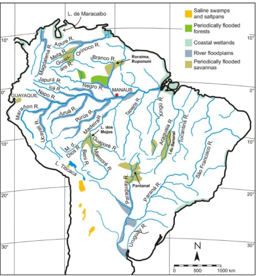
As zonas úmidas do Rio Araguaia, incluindo a Ilha do Bananal, destacam-se no Brasil Central (Figura 1), por suas seguintes principais características (JUNK et al., 2013): são ecossistemas de interface entre ambientes aquáticos e terrestres; podem ser permanentemente ou periodicamente inundados e abrigam comunidades de plantas e animais adaptados à sua dinâmica hidrológica. Esses autores destacaram ainda que a extensão das zonas úmidas pode ser determinada pela área permanentemente inundada ou pelo limite da área influenciada durante a inundação máxima média, devendo incluir, caso existam, as áreas internas permanentemente secas que são fundamentais para a manutenção da integridade ecológica dessas regiões.
A produção primária de gramíneas em ambientes de várzeas é compatível com a produção comercial do milho em regiões de clima temperado quente (PIEDADE et al., 1991; MORISON et al. 2000). A vegetação herbácea que cresce às margens de grandes rios e em ambientes de várzea apresenta ainda forte relação com a hidrodinâmica do rio (NEIFF, 1990), podendo atingir taxas bastante elevadas de produtividade primária bruta, porém, sua biomassa máxima permanente é geralmente menor (JUNK e PIEDADE, 1993).
11
Figura 1 - Distribuição das principais áreas úmidas no norte da América do Sul. Fonte:
Junk et al. (2014).
Apesar da planície de inundação do Rio Araguaia pertencer ao grupo de três sistemas de áreas úmidas de savana no sul da bacia Amazônica (IRION et al., 2016), ela tem sofrido ameaças da expansão de novas áreas de agricultura e pecuária (PIEDADE et al., 2012). Esse cenário de mudanças da cobertura da terra mostra-se ainda mais sensível no caso dessas planícies aluviais tropicais, pois são consideradas uma das paisagens mais produtivas com alta variabilidade espacial e temporal de taxas de produção primária e suas relações com os aportes de sedimentos e nutrientes nesse sistema (DAVIES et al. 2008). Esses impactos antrópicos podem afetar a dinâmica hidrogeomorfológica de grandes rios tão rapidamente quanto em bacias de pequeno e médio porte (LATRUBESSE et al., 2009). Esses autores relataram um aumento da vazão e um elevado aporte de sedimentos no canal principal do rio e áreas próximas à planície aluvial, em um período da ordem de uma década para a bacia do Araguaia.
Um dos principais avanços da tecnologia espacial que permitiu a ampliação da compreensão espacial e temporal de feições da superfície terrestre foi o lançamento do
12
sensor denominado Moderate Resolution Imaging Spectroradiometer (MODIS) que, desde 2000, tem disponibilizado imagens digitais que expressam as condições biofísicas da superfície da Terra, por exemplo, por meio de índices de vegetação e produtividade primária (JUSTICE et al., 2002; LATORRE, 2003). Esse sensor dispõe de alta resolução espectral e temporal, viabilizando estudos de monitoramento global da atmosfera, terra e oceano, sendo possível definir o fluxo dinâmico e sazonal do carbono na superfície terrestre, estimar rendimento de colheitas, produtividade de florestas e outros produtos associados ao crescimento da vegetação (RUNNING et al. 2004; SAKAMOTO et al. 2011; NASA, 2018). Os dados derivados de diferentes produtos deste sensor têm um potencial para análises integradas dos padrões e mudanças da cobertura vegetal, inclusive para áreas de inundação, que apresentam um regime hídrico intenso e comportamentos bem particulares (AQUINO et al., 2005; PEREIRA et al., 2011). A integração desses dados orbitais permite avaliar os padrões temporais da produtividade primária, inferir sobre estoques do carbono e evidências sobre as mudanças climáticas em escala regional e global (RUNNING et al. 2004; ZHANG et al., 2017; YU et al., 2018).
Considerando a contextualização apresentada, o objetivo desta dissertação foi caracterizar os padrões temporais de produtividade primária bruta da cobertura da terra e dos domínios de relevo da bacia do Rio Araguaia. Para alcançar esse propósito, foi desenvolvido o artigo intitulado “Temporal patterns of Gross Primary Productivity of
land cover in the Araguaia Basin”, que apresenta os principais padrões temporais de GPP
no contexto dos domínios de relevo e cobertura da terra, ao nível de subbacias presentes em seu interior.
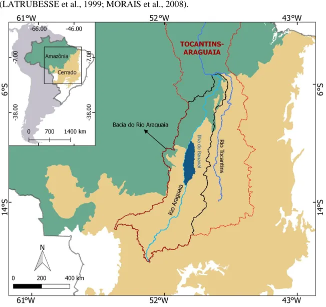
Área de Estudo
A Região Hidrográfica Tocantins-Araguaia possui uma área de aproximadamente 920.000 km², abrangendo um total de 409 municípios distribuídos entre os estados de Goiás, Tocantins, Mato Grosso, Pará, Maranhão e Distrito Federal, com uma população de aproximadamente 8,6 milhões de habitantes (IBGE, 2010). O Rio Araguaia, com uma extensão de mais de 2.000 km, é típico de planície, com ambientes compostos por rochas sedimentares do Paleozoico e Mesozoico, entremeadas por paisagens acidentadas em que o rio corre encaixado sobre rochas pré-cambrianas (LATRUBESSE e STEVAUX, 2002). A bacia do Rio Araguaia está localizada no Brasil Central e apresenta uma zona de
13
transição entre os biomas Amazônia e Cerrado (Figura 2), uma transição ecológica que vem sofrendo um processo contínuo de desmatamento e queimadas para exploração madeireira, produção de carvão vegetal e agropecuária (ANA, 2009).
Segundo a classificação climática de Koeppen (ALVARES et. Al., 2013), a bacia hidrográfica do Rio Araguaia está inserida na zona climática tropical, com clima predominante Aw (tropical com inverno seco), caracterizado pela sazonalidade típica das áreas de Cerrado, com índices pluviométricos e termométricos crescentes no sentido sul– norte. Ressaltam-se as zonas de transição entre Cerrado e Amazônia, com maior ocorrência do bioma Amazônia na parte norte da bacia (LATRUBESSE e STEVAUX, 2002). As cheias do rio ocorrem entre janeiro a abril, com sazonalidade bem definida, isto é, estação chuvosa que vai de outubro a abril, e estação seca que vai de maio até setembro (LATRUBESSE et al., 1999; MORAIS et al., 2008).
Figura 2 - Mapa de localização da bacia do Rio Araguaia em relação aos biomas
14
A planície aluvial do médio Araguaia é um complexo mosaico de unidades morfo-sedimentares, resultantes de uma sucessão de eventos paleohidrológicos, associadas às coberturas cenozoicas recentes e responsáveis pela formação da ilha do Bananal, maior ilha fluvial do mundo (LATRUBESSE e STEVAUX, 2002; MORAIS et al., 2008). A jusante da Planície do Bananal, surge o Baixo Araguaia que se desenvolve sobre áreas de rochas cristalinas do Pré-Cambriano, até sua confluência com o Rio Tocantins (LATRUBESSE e STEVAUX, 2002, 2009; LATRUBESSE e CAVALHO, 2006).
15
CAPÍTULO 2 – TEMPORAL PATTERNS OF GROSS PRIMARY
PRODUCTIVITY OF LAND COVER IN THE ARAGUAIA BASIN
ABSTRACT - The Araguaia river basin is located in Central Brazil and presents wide
diversity of environments in a transition zone between the Cerrado and Amazonia biomes. Geomorphology basically controls the spatial and temporal dynamics of land cover. The primary productivity of vegetation is one of the most relevant processes to assess global carbon balance and climate change and can be estimated using remote sensing data. The objective of this study was to propose a systemic approach to survey the landscape of Araguaia river basin. The primary data corresponded to topographic data, land cover map, and the gross primary productivity (GPP) data generated from a 15-year time series of the MOD17A2HV6 product from the Moderate Resolution Imaging Spectroradiometer (MODIS). We observed that the pastures have a wide and heterogeneous distribution throughout the Araguaia river basin, while agricultural areas are mostly concentrated on relatively old, high elevation, and flat topographies (plateaus), which can represent a negative factor for the conservation of the region. Forest areas showed the highest annual mean GPPs throughout the period, proving to be a key component for estimating the carbon sequestration on regional and global scales.
1. Introduction
Brazil has one of the largest river networks in the world, distributed in 12 hydrographic regions. Among the major Brazilian river networks, the Tocantins-Araguaia hydrographic region covers around 11% of the Brazilian territory, with its largest portion located in the Center-West region of the country. Besides representing more than 41% of this specific hydrographic region and hosting the Bananal Island, the largest river island in the world, the Araguaia River basin plays a key role in terms of wetland conservation (LATRUBESSE et al., 2009). This is because the two largest biomes of the South America are present: the Amazonia, which has the largest forestlands and largest river basin in the world (IBGE, 2004; ANA, 2015), corresponding to 23% of the total basin area, in the north; and the Cerrado (Brazilian savanna), one of the world's hotspots for biodiversity conservation, representing 77% of the basin (MYERS et al., 2000; SILVA and BATES, 2002; KLINK and MACHADO, 2005).
Even with its remarkable importance for the maintenance of key wetland areas in central Brazil and being considered a priority area for conservation of aquatic biodiversity in the Cerrado (GETZNER, 2002; AQUINO, 2008; JUNK et al., 2014), the Araguaia River basin still presents little relevance in the international literature regarding large rivers. Its research is still relatively scarce (LATRUBESSE, 2002), although several efforts have been made in fields such as geomorphology, hydrology, ecology, and remote
16
sensing (LATRUBESSE and STEVAUX 2002, 2006; CARVALHO and LATRUBESSE, 2004; MARINHO et al., 2006; MORAIS et al., 2008; AQUINO et al., 2009; LATRUBESSE et al., 2009; IRION et al., 2016; LININGER and LATUBESSE, 2016).
The dynamics of natural landscapes are constantly modified by human activities and are intensified as the population grows and technology improves. Measuring these impacts has been a complex task. However, it is possible to characterize worldwide patterns and trends in agriculture and environment, which are crucial for formulation and implementation of regional and global policies (FOLEY et al., 2011; HANSEN et al., 2013). It is important to note that the current situation of the basin is a result of temporal changes that happened in a similar manner in the Cerrado biome (LATRUBESSE et al., 2009; COE et al., 2011) which went through intense transformations in the last decades, mainly because of extensive livestock farming and crop production, resulting in a loss of around half of its native vegetation (SANO et al., 2008, 2010).
The Moderate Resolution Imaging Spectroradiometer (MODIS) sensor onboard the Terra and Aqua platforms produces ready-to-use time series of vegetation indices, fractional photosynthetically active radiation, and net primary productivity, among others (LATORRE, 2003; RUNNING et al., 2004; SAKAMOTO et al., 2011). MOD17A2H (gross primary productivity) and MOD17A3H (net primary productivity) are part of the National Aeronautics and Space Administration (NASA) Earth Observation System (EOS) products. They are the first satellite-driven dataset to monitor vegetation productivity on a global scale (NASA, 2018). MOD17 data allow an integrated analysis of the patterns of vegetation cover and its changes, especially in the case of wetlands, which present high water dynamics (FLORENZANO, 2005; DAVIES et al., 2008; PEREIRA, 2011).
Freshwater wetlands provide a potential sink of atmospheric carbon, however, if not managed properly, they can become a source of greenhouse gases (KAYRANLI et al., 2010). In addition, more research is needed to understand the impacts of water level fluctuations on carbon fluxes under variable climatic regimes, especially the spatial distribution of relevant wetland characteristics. The vegetation photosynthesis at the ecosystem scale, also known as the gross primary productivity (GPP), is the first step in
the process of carbon dioxide (CO2) entering the biosphere from the atmosphere (ZHANG
17
vegetation is crucial to understand the global carbon cycle and predict future climate change.
Considering the importance So far, no research has demonstrated the spatiotemporal variability of variables for quantifying carbon cycle in the Araguaia’s basin. In this sense, the objective of this study is to characterize the topography and to correlate it with both land cover and GPP in the Araguaia River basin, which is a centerpiece for the maintenance of tropical biomes such as the Cerrado and the Amazonia. The purpose of this approach is to understand the spatial distribution of land cover through GPP in a systemic context of the landscape.
2. Study Area
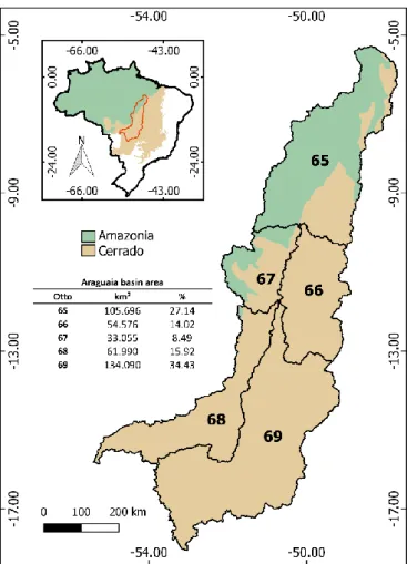
According to Latrubesse and Stevaux (2002), the Araguaia River basin can be divided in High, Middle, and Low compartments. The High Araguaia extends through 450 km of dominant mountain valleys and is controlled by lithological and structural elements formed by Pre-Cambrian and Paleozoic rocks. The Middle Araguaia has the largest contribution area and holds the largest tributaries of the basin, encompassing the Bananal plain, a Quaternary sedimentary basin of low topography occupying approximately 5% of the basin. A prominent feature is the well-developed alluvial plains with some outcrops, composed by Holocene and late Pleistocene sedimentary units. The Low Araguaia, on the other hand, presents almost no alluvial plain. The river, with around 500 km of extent, flows through areas with strong structural control formed by Pre-Cambrian crystalline rocks, up to its confluence with the Tocantins River.
The present study is based in the ottocoded watersheds proposed by the National Water Agency (ANA). This data were based on the Otto Pfafstetter watershed coding method (PFAFSTETTER, 1989), established by the National Council of Water Resources (CNRH) (Resolution no. 30/2002) as the official codification of river basins in Brazil. This method adopts a hierarchical and multiscale coding logic for river basins. The limits are generated from digital elevation models (DEM) derived from the Shuttle Radar Topography Mission (SRTM) with spatial resolution of 90 m, enabling a more realistic representation of interfluves. These, in turn, allow a better systematization of remote sensing data and the integration with different geographic information systems (GIS) databases.
18
The ottocoded hydrographic basin are classified from levels 1 to 6, based on the degree of disaggregation. We selected the level 2 with the aim of obtaining an integration of equal proportions between the scales of the different regional and global databases used in this study. The vector-format ottocoded hydrographic basins (shapefiles) can be obtained freely from the ANA´s website (http://metadados.ana.gov.br). Details of the ottobasins are presented in Figure 1.
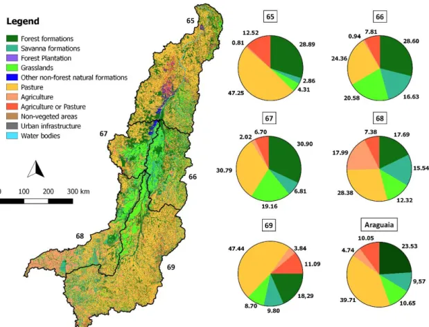
Figure 1 - Upper left: map of the location of the Araguaia River basin in relation to the
Cerrado and the Amazonia biomes. Lower right: divisions by ottobasins according to the National Water Agency (ANA).
Morphological Domains
The topography data were obtained from the Geodiversity mapping available at the Brazilian Geological Service (CPRM - http://www.cprm.gov.br/publique/Gestao-Territorial/Geodiversidade-162), which provides good potential for integrated studies. In this study, it was used a hierarchical approach to geomorphological information on morphological domain levels (Figure 2). According to the geodiversity data (DANTAS,
19
2013), four domains are found in the Araguaia River basin: Domain I - Aggradational Units; Domain III - Denudational Units in Litified Sedimentary Rocks; Domain IV - Flat Reliefs; and Domain V - Denudational Units in Crystaline or Sedimentary Rocks.
Figure 1 - Spatial distribution of morphological domains in the Araguaia River basin, based on geodiversity mapping produced by the Brazilian Geological Service (CPRM). The domains are listed by order of topographic plane. On the right, the percentage of occurrence of each domain is presented in charts per basin.
The Aggradational Units (Domain I) comprises a large set of fluvial, marine, gravitational and wind depositional environments, generating the various Quaternary plains and occurring on 29% of the total area of the Araguaia basin. This domain is mostly present in ottobasins 66 and 67 (Middle Araguaia) through 68 and 69 (Upper Araguaia). The Denudational Units in Litified Sedimentary Rocks (Domain III) occurs on 12% of the Araguaia basin and is comprised of elevated and flat tops, usually formed in intracratonic sedimentary basins during the Paleozoic and Mesozoic. The main forms of relief observed in these regions are plateaus similar to those formed in the Paraná, Parnaíba, Amazonas and Sanfranciscana sedimentary basins. This domain is mainly observed in the southwestern portion of the Araguaia (ottobasin 68), which, because of its continuous and flat relief, can be an indicator of where large-scale anthropogenic activities, such as monocultures, are concentrated.
20
Occupying 28% of the Araguaia River basin, the Flat Reliefs (Domain IV) encompasses extensive eroded surfaces with flat relief that occupy the basis of the current interplanaltic depressions, representing a transition from more resistant, older reliefs to more recent ones (depressions to aluvial plains). Lastly, the Domain of Denudational Units in Crystalline or Sedimentary Rocks (V) is composed of a diverse set of relief patterns found in any lithology and occurring on 29.79% of the Araguaia basin. This Domain includes all types of dissected terrain, ranging from broad hills with smooth morphology to rough terrain of mountainous masses and mountain escarpments, which are mostly observed in ottobasin 69 (Upper Araguaia).
Land Cover Spatial Patterns
The land use and land cover data considered in this study (year 2016) was produced by the MapBiomas project, collection 2.3, which provides an annual data of land use and land cover maps of Brazil since 2000, based on the time series of Landsat satellite automated image classification with the support of the Google Earth Engine platform. According to the 2016 landcover map of MapBiomas, the most predominant classes in the Araguaia basin are pasture (40%), forest formations (24%), grasslands (11%) and savannas (10%). Pastures are present in all morphological domains, while agriculture is mainly concentrated in Denudational Units in Sedimentary Rocks (Domain III), probably because of its high plateaus. These relief patterns can be observed mainly in High Araguaia (ottobasins 68 and 69), representing 30% and 14% respectively.
The natural land covers (forestlands, shrublands, and grasslands) occur mainly in Middle Araguaia. This is justified by the lack of morphological characteristics that are susceptible to large-scale anthropogenic interventions in this region, which restricts the establishment of activities such as agriculture and livestock productions. Considering that 56% of ottobasin 66 and 53% of ottobasin 67 are composed of Aggradational Units, constantly subjected to flood events caused by fluvial dynamics, it is expected that the largest fragments of natural formations would be found in these areas (Figure 3).
The dynamics between relief and land cover can better explain the behavior of the vegetation in terms of biomass production and carbon storage throughout the basin, being the central focus of the discussion section.
21
Figure 2 - Percentage of land cover classes in the Araguaia basin according to the
MapBiomas collection 2.3. Higher-occurrence classes represented in the charts on the right.
3. Material and Methods
Climate Data
Climate data from WorldClim version 2 were used to characterize the seasonality and its link with GPP in the Araguaia basin. Precipitation averages were calculated by interpolating data from weather stations with temporal range of 1970–2000, and spatial resolution of 1 km2,which can be used in mappings and spatial modeling (FICK and
HIJMANS, 2017).
Temporal GPP patterns
In this study, it was used the MOD17A2HV6 GPP product, a cumulative 8-day composites with 500-meter pixel size from MODIS sensor onboard the Terra platform (RUNNING et al., 2015). This product is based on the radiation-use efficiency concept that can be potentially used to estimate terrestrial energy and carbon, water cycle
22
processes, and biogeochemistry of the vegetation models (RUNNING et al., 2004; ZHAO et al., 2005).
A set of 724 scenes was selected, comprising almost 16 years of time series (February/2000 to November/2015). The data were smoothed from atmospheric interferences and instrumental artifacts with a median filter and Minimum Noise Fraction (MNF) transformations (CARVALHO Jr. et al., 2012). After the data smoothing, the land cover temporal patterns from the Araguaia basin and from each level-2 otto codification sub-basins (65, 66, 67, 68 and 69), by month and integrated with the precipitation data (Worldclim). To highlight the annual shifts, we used the 1st derivative of the month value for each land cover by basin.
4. Results and Discussion
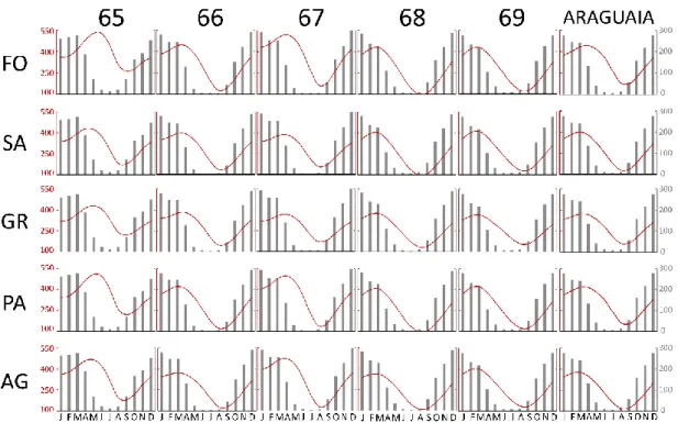
Forest formations can keep an almost constant canopy cover throughout the year, maintaining biomass production higher than other natural formations even during dry season from April to September, with 16% of the total precipitation in the Araguaia basin (Figure 4). On the other hand, non-forest formations and pastures behave differently and undergo more rigorous transformations because of seasonal climatic changes (BECERRA et al., 2009) and in the floods, when much of the vegetation in the floodplain oscillates with river fluctuations (DAVIES et al., 2008; JUNK and PIEDADE, 1993).
Seasonality of GPP in the Araguaia basin can be observed through the monthly averages extracted from the WorldClim data. The strong relationship between vegetation productivity and precipitation occurs in all ottobasins (Figure 4). Variations in the precipitation distribution can significantly alter vegetation spatial distribution and energy processes (SCHUUR, 2003; HUXMAN et al., 2004; DALMAGRO et al., 2011), and it is worth noting that there are great diversity of phytophysiognomies, which have a particular time of response in the intervals between dry and rainy seasons.
The GPP presented marked seasonality, with curves tending to accompany precipitation, with peaks in the rainy periods and decrease in drought. All the cover classes presented similar curves between them. The differences are greater when observed between the basins (horizontal direction of figure 4) than between the land cover classes (vertical). This reveals that the ottobacias have particular regional responses in the seasonality of the vegetation, and that the land cover does not behave homogeneously in the Araguaia basin as a whole.
23
Figure 3 - Average monthly GPP and precipitation discriminated by ottobasin and land use and land cover classes. FO = forestlands; SA = shrublands (savanna); GR = grasslands; PA = pasturelands; AG = croplands (agriculture).
Photosynthesis is one of the most sensitive physiological processes to the climate, which directly affects the carbon fixation processes (VOURLITIS et al., 2011). However, historical averages of precipitation are insufficient to explain the phenological behavior of the different phytophysiognomies and the dynamics of GPP in tropical ecosystems, particularly in areas with low weather station density, where prediction errors are usually high because of all climate variables (FICK and HIJMANS, 2017).
All land use and land cover classes presented highest GPP averages in ottobasins 65 and 67, and lowest GPP in ottobasins 68 and 69. This indicates a decreasing pattern of GPP in the North/South direction. These results indicate that there may have been interannual variations due to the climatic conditions that change over the study period, highlighting the occurrence of the transition areas of Amazonia/Cerrado in the northern part of the basin. It also indicates the occurrence of seasonal droughts. The interannual variables are probably the most important interfering factors to the productivity of tropical ecosystems and carbon cycling processes.
The forest formations maintained the highest average of GPP in all ottobasins of
the Araguaia, with a minimum of 269 g C m-2 in sub-basin 68, and a maximum of 387 g
C m-2 in ottobasin 65. The annual average of GPP in forest formations in the entire
24
ottobasin 68 and a maximum of 360 g C m-2 in ottobasin 65. It is important to note that, despite the high rates of primary productivity presented by pastures, the amount of biomass produced does not last in the system as it does in forest compartments or in other forest formations of the Cerrado, for example.
In general, the shrublands, grasslands, and agricultural classes alternated between low and intermediate mean annual GPP over the time period considered. These classes had minimum and maximum variations (ottobasins 68 and 65, respectively) from 252 to 316 g C m-2 in the savanna, from 258 to 327 g C m-2 in the grasslands and from 242 to 336 g C m-2 in agricultural areas.
Lower averages and lower differentiation between these classes possibly happen because the potential light use efficiency does not show difference between C3 and C4 species for some classes in the MODIS data, considering that C4 crop species, for example, have higher photosynthetic capacity compared to C3 species (TAO YU et al., 2018). Another aspect is that there may be inconsistency between MapBiomas classes and actual coverage, as in grasslands that are often classified as pastures, overestimating the values of one class over another.
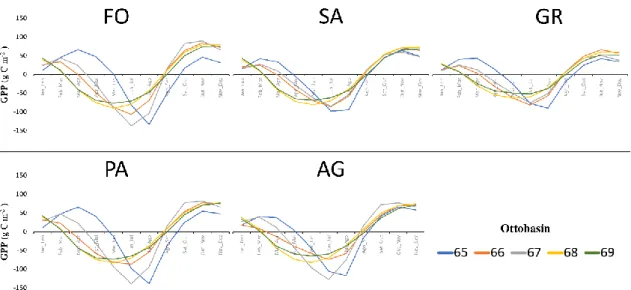
Figure 4 – 1st Derivatives of GPP averages per land use and land cover classes and
ottobasins. Legend: FO - forestlands; SA - shrublands (savanna); GR - grasslands; PA - pasturelands; AG - agriculture.
In general, higher losses of GPP rates were mainly concentrated between April to October (dry season) in each basin. The ottobasins 65, 66 and 67 maintained higher GPP gains during the first months of the year, with emphasis on the forestlands and pasturelands, while other classes showed lower values. However, forestlands and pasturelands in these ottobasins presented higher amplitudes of loss of GPP and higher
25
delay in returning to positive values. In the southern region of the Araguaia basin (ottobasins 69 and 68), vegetation presents less abrupt variation in GPP, with losses in January and February, and gains in August and September, when they are equal or even surpass the averages observed in ottobasins 65, 66 and 67 (Figure 5).
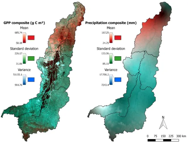
In order to better understand the spatiotemporal patterns of the Araguaia basin, the mean, standard deviation and variance of GPP and precipitation were combined in RGB color composites (Figure 6). The basin presents a good contrast between areas that had high GPP variation over time (bluish and greenish tones, associated with standard deviation and variance), and regions better represented by the means, that is, indicate a more stable temporal pattern, which tend to reddish tones.
The areas highlighted by the mean were mainly forestlands, while the majority of the basin, mainly occupied by pasturelands, indicates more dynamic changes in land use and land cover over time. The precipitation composition presented a similar appearance, with the northern region being more represented by the mean (Figura 6). It is possible that this is because ottobasin 65 contains the largest ecotone area of the basin, expressing greater climatic influence by the transition between Amazonia and Cerrado biomes.
Figure 5 – Gross Primary Productivity composition (GPP): R-Mean; G-Standard
deviation; B-Variance (left); Precipitation: R-Mean; G-Standard deviation; B-Variance (right).
26
It is important to note that studies of biomass estimate of underground roots are even scarcer than aerial biomass determinations. Castro and Kauffmann (1998) analyzed data of underground biomass and observed a variation of 16.3 t ha-1 to 52,9 t ha-1 for different Cerrado’s phytophysiognomies. The deep woody roots of the Cerrado biome, which can grow up to 18 meters, are adapted to capture water and nutrients from poor and deep soils (RAWITSCHER, 1948), and also become place for large carbon stocks, which is why the root/vegetation ratio ends up being ignored by studies that stick to interactions that occur above ground.
Thus, a considerable part of the biomass produced in tropical biomes is not stored only in the aerial compartment of the vegetation, which reveals the need of new approaches to estimate, through integrated models, the total contribution of the different land use and land cover classes to the amount of primary productivity and carbon sequestration at regional and global scales.
5. Conclusions
The integrated assessment of existing baselines with land use and land cover, and with the GPP map generated from MODIS data was efficient in the basic characterization of the land cover dynamics and carbon sequestration in the Araguaia Basin.
The forest formations were the classes that most contributed to the amount of primary productivity during the studied period, functioning as large sinks of carbon on the terrestrial surface. Although the grasslands and savanna formations presented less representation for the carbon sequestration in the region, these formations correspond to important areas of remaining natural vegetation in the Middle Araguaia.
There is a great heterogeneity in the spatial distribution of pastures along the Araguaia Basin, and a concentration of agricultural activities over the Domain III, formed by older reliefs, with flat and raised tops. Such distribution emphasizes the need for continuous efforts related to conservation actions directed not only to areas of forest remnants but also to the natural landscapes located over reliefs that are more susceptible to human interventions.
27
REFERÊNCIAS BIBLIOGRÁFICAS
ALVARES, C.A.; STAPE, J.L.; SENTELHAS, P.C.; GONÇALVES, J.L.M.; SPAROVEK, G. Köppen’s climate classification map for Brazil. Meteorologische
Zeitschrift, v. 22, n. 6, p. 711–728, 2014.
AGÊNCIA NACIONAL DE ÁGUAS (ANA). Plano estratégico de recursos hídricos
da bacia hidrográfica dos rios Tocantins e Araguaia: relatório-síntese. Brasília:
ANA, 2009. Disponível em: <http://biblioteca.ana.gov.br/index.asp?
codigo_sophia=3357>. Acesso em: 7 de julho de 2018.
AGÊNCIA NACIONAL DE ÁGUAS (ANA). Conjuntura dos recursos hídricos no
Brasil: regiões hidrográficas brasileiras 2013. Brasília: ANA, 2013.
AGÊNCIA NACIONAL DE ÁGUAS (ANA). Conjuntura dos recursos hídricos no
Brasil: regiões hidrográficas brasileiras – Edição Especial. Brasília: ANA, 2015.
AQUINO, S.; STEVAUX, L.C.; LATRUBESSE, E.M. Regime hidrológico e aspectos do comportamento morfohidráulico do rio Araguaia. Revista Brasileira de
Geomorfologia, v. 6, n. 2, p. 29-41, 2005.
AQUINO, S.; LATRUBESSE, E.; BAYER, M. Assessment of wash load transport in the Araguaia river (Aruanã gauge station), Central Brazil. Latin American Journal of
Sedimentology and Basin Analysis, v. 16, n. 2, p. 119-128, 2009.
AQUINO, S.; LATRUBESSE, E.M.; SOUZA FILHO, E.E. Caracterização hidrológica e geomorfológica dos afluentes da Bacia do Rio Araguaia. Revista Brasileira de
Geomorfologia, v. 10, n. 1, p. 43-54, 2009.
AQUINO, S.; LATRUBESSE, E.M.; SOUZA FILHO, E.E. Relações entre o regime hidrológico e os ecossistemas aquáticos da planície aluvial do rio Araguaia. Acta
Scientiarum Biological Sciences, v. 30, n. 4, p. 361-369, 2008.
BECERRA, J.A.B.; SHIMABUKURO, Y.E.; ALVALÁ, R.C.S. Relação do padrão sazonal da vegetação com a precipitação na região de Cerrado da Amazônia Legal, usando índices espectrais de vegetação. Revista Brasileira de Meteorologia, v. 24, n. 2, p. 125-134, 2009.
CARVALHO, T.M.; LATRUBESSE, E.M. Aplicação de modelos digitais do terreno (MDT) em análises macrogeomorfológicas: o caso da bacia hidrográfica do Araguaia.
Revista Brasileira de Geomorfologia, ano 5, n. 1, p. 85-93, 2004.
CARVALHO JÚNIOR, O.A.; SILVA, N.C.; CARVALHO, A.P.F.; COUTO JÚNIOR, A.F.; SILVA, C.R.; SHIMABUKURO, Y.E.; GUIMARÃES, R.F.; GOMES, R.A.T. Combining noise-adjusted principal components transform and median filter techniques for denoising MODIS temporal signatures. Revista Brasileira de Geofísica, v. 30, n. 2, p. 147-157, 2012.
28
CASTRO, E.A.; KAUFFMAN, J.B. Ecosystem structure in the Brazilian Cerrado: a vegetation gradient of aboveground biomass, root mass and consumption by fire. Journal
of Tropical Ecology, v. 14, n. 3, p. 263-283, 1998.
COE, M.T.; LATRUBESSE, E.M.; FERREIRA, M.E.; AMSLER, M.L. The effects of deforestation and climate variability on the streamflow of the Araguaia River, Brazil.
Biogeochemistry, v. 105, p. 119-131, 2011.
DALMAGRO, H.J.; LOBO, F.A.; ORTÍZ, C.E.R.; BIUDES, M.S.; NOGUEIRA, J.S.; VOURLITIS, G.L.; PINTO JUNIOR, O.B. Trocas gasosas de uma espécie lenhosa na floresta de transição Amazônia-Cerrado. Ciência e Natura, v. 33, n. 2, p. 147-165, 2011. DAVIES, P.M.; BUNN, S.E.; HAMILTON, S.K. Primary production in tropical streams and rivers. In: DUDGEON, D. (ed.), Tropical Stream Ecology, Elsevier Inc., p. 23-42, 2008.
DANTAS, M.E. Análise de padrões de relevo: Um instrumento aplicado ao mapeamento da geodiversidade. In: BANDEIRA, I.C.N (Org.), Geodiversidade do Estado do
Maranhão. Programa Geologia do Brasil, Teresina, p. 133-140, 2013.
FICK, S.E.; HIJMANS, R.J. WorldClim 2: new 1-km spatial resolution climate surfaces for global land areas. International Journal of Climatology, v. 37, p. 4302-4315, 2017. FLORENZANO, T.G. Geotecnologias na geografia aplicada: difusão e acesso. Revista
do Departamento de Geografia, v. 17, p. 24-29, 2017.
FOLEY, J.A.; RAMANKUTTY, N.; BRAUMAN, K.A.; CASSIDY, E.S.; GERBER, J.S.; JOHNSTON, M.; MUELLER, N.D.; O’ CONNEL, C.; RAY, D.K.; WEST, P.C.; BALZER, C.; BENNET, E.M.; CARPENTER, S.R.; HILL, J.; MONFREDA, C.; POLASKY, S.; ROCKSTRÖM, J.; SHEEHAN, J.; SIEBERT, S.; TILMAN, D.; ZARKS, D.P.M. Solutions for a Cultivated Planet. Nature, 6 p., 2011.
GETZNER, M. Investigating public decisions about protecting wetlands. Journal of
Environmental Management, v. 64, p. 237–246, 2002.
GOPAL, B. The role of ecotones (transition zones) in the conservation and management of tropical inland waters, SIL Communications, 1953-1996. Internationale Vereinigung
für Theoretische und Angewandte Limnologie: Mitteilungen, v. 24, n. 1, p. 17-25,
1994.
HANSEN, M.C.; POTAPOV, P.V.; MOORE, R.; HANCHER, M.; TURUBANOVA, S.A.; TYUKAVINA, A.; THAU, D.; SETHMAN, S.V.; GOETZ, S.J.; LOVELAND, T.R.; KOMMAREDDY, A.; EGOROV, A.; CHINI, L.; JUSTICE, C.O. TOWNSHEND, J.R.G. High-resolution global maps of 21st-century forest cover change. Science, v. 342, n. 6160, p. 850-853, 2013.
HUXMAN, T.; SMITH, M.; FAY, P.A.; KNAPP, A.K.; SHAW, R.; LOIK, M.E.; SMITH, S.D.; TISSUE, D.T.; ZAK, J.C.; WELTZIN, J.F.; POCKMAN, W.T.; SALA, O.E.; HADDAD, B.B.; HARTE, J.; KOCH, G.W.; SCHWINNING, S.; SMALL, E.E.;
29
WILLIAMS, D.G. Convergence across biomes to a common rain-use efficiency. Nature, v. 429, p. 651-654, 2004.
IBGE. 2004. Mapa de Biomas do Brasil, primeira aproximação. Rio de Janeiro: IBGE. Disponível em: <www.ibge.gov.br>. Acesso em: 15 de junho de 2018.
IRION, G.; NUNES, G.M.; CUNHA, C.N.; ARRUDA, E.C.; TAMBELINI, M.S.; DIAS, A.P.; MORAIS, J.O.; JUNK, W.J. Araguaia River floodplain: size, age, and mineral composition of a large tropical savanna wetland. Wetlands, v. 36, n. 5, p. 945-956, 2016. JUNK, W.J. Freshwater fishes of South America: Their biodiversity, fisheries, and habitats—a synthesis. Aquatic Ecosystem Health & Management, v. 10, n. 2, p. 228-242, 2007.
JUNK, W.J.; SPARKS, R.E. The Flood Pulse Concept in River-Floodplain Systems.
Journal of Fisheries and Aquatic Sciences, p. 110-127, 1989.
JUNK, W.J.; PIEDADE, M.T. Biomass and primary-production of herbaceous plant communities in the Amazon floodplain. Hydrobiologia, v. 263, p. 155-162, 1993. JUNK, W.J.; PIEDADE, M.T.; LOURIVAL, R.; WITTMANN, F.; KANDUS, P.; LACERDA, L.D.; BOZELLI, R.L.; ESTEVES, F.A.; CUNHA, C.N.; MALTCHIK, L.; SCHÖNGART, J.; SCHAEFFER-NOVELLI, Y.; AGOSTINHO, A.A. Brazilian wetlands: their definition, delineation, and classification for research, sustainable management, and protection. Aquatic Conservation: Marine and Freshwater
Ecosystems, v. 24, p. 5–22, 2014.
JUSTICE, C.O.; TOWNSHEND, J.R.G.; VERMOTE, E.F.; MASUOKA, E.; WOLFE, R.E.; SALEOUS, N.; ROY, D.P.; MORISETTE, J.T. An overview of MODIS Land data processing and product status. Remote Sensing of Environment, v. 83, n. 1-2, p. 3-15, 2002.
KAYRANLI, B.; SCHOLZ, M.; MUSTAFA, A.; HEDMARK, A. Carbon storage and fluxes within freshwater wetlands: a critical review. Wetlands, v. 30, p. 11-114, 2010. KLINK, C.A.; MACHADO, R.B. A conservação do Cerrado brasileiro.
Megadiversidade, v. 1, n. 1, p. 147-155, 2005.
LATORRE, M.L.; ANDERSON, L.O.; SHIMABUKURO, Y.E.; CARVALHO JÚNIOR, O.A. Sensor MODIS: características gerais e aplicações. Espaço & Geografia, v. 6, n. 1, p. 91-121, 2003.
LATRUBESSE, E.M.; AMSLER, M.L.; MORAIS, R.P.; AQUINO, S. The geomorphologic response of a large pristine alluvial river to tremendous deforestation in the South American tropics: The case of the Araguaia River. Geomorphology, v. 113, p. 239–252, 2009.
LATRUBESSE, E.M.; CARVALHO, T.M. Geomorfologia do Estado de Goiás e
Distrito Federal, Goiânia, Secretaria de Indústria e Comércio, 128 p., 2006 (Série
30
LATRUBESSE, E.M.; STEVAUX, J.C.; BAYER M.; PRADO, R. The Araguaia-Tocantins fluvial basin. Boletim Goiano de Geografia, v. 19, n. 1, p. 120-127, 1999. LATRUBESSE, E.M.; STEVAUX, J.C. Características físico-bióticas e problemas ambientais associados à planície aluvial do Rio Araguaia, Brasil Central. Revista UnG-
Geociências, v. 5, n. 1, p. 65-73, 2006.
LATRUBESSE, E.M.; STEVAUX, J.C. Geomorphology and environmental aspects of the Araguaia fluvial basin, Brazil. Zeitschrift fuer Geomorphologie N.F. Berlin, v. 129, p. 109-127, 2002.
LININGER, K.B.; LATRUBESSE, E.M. Flooding hydrology and peak discharge attenuation along the middle Araguaia River in central Brazil. Catena, v. 143, p. 90-101, 2016.
MALHI, Y.; BALDOCCHI, D.D.; JARVIS, P.G. The carbon balance of tropical, temperate and boreal forests. Plant, Cell and Environment, v. 22, p. 715–740, 1999. MARINHO, G.V.; CASTRO, S.S.; CAMPOS, A.B. Hydrology and gully processes in the upper Araguaia River basin, Central Brazil. Zeitschrift fuer Geomorphologie N.F., v. 145, p. 119-145, 2006.
MORAIS, R.P.; AQUINO, S.; LATRUBESSE, E.M. Controles hidrogeomorfológicos nas unidades vegetacionais da planície aluvial do rio Araguaia, Brasil. Acta Scientiarum
Biological Sciences, v. 30, n. 4, p. 411-421, 2008.
MORISON, J.I.L.; PIEDADE, M.T.F.; MÜLLER, E.; LONG, S.P.; JUNK, W.J.; JONES, M.B. Very high productivity of the C4 aquatic grass Echinochloa polystachya in the
Amazon floodplain confirmed by net ecosystem CO2 flux measurements. Oecologia, v.
125, p. 400-411, 2000.
MYERS, N.; MITTERMEIER, R.A.; MITTERMEIER, C.G.; FONSECA, G.A.B.; KENT, J. Biodiversity hotspots for conservation priorities. Nature, v. 403, n. 6772, p. 853-858, 2000.
NAIMAN, R.J.; DÉCAMPS, H.; FOURNIER, F. Role of land/inland water ecotones
in landscape management and restoration. Proposals for collaborative research.
Unesco, Paris, 1989, 85 p. (M A B Digest Series, 4.).
NARANJO, L.G. An evaluation of the first inventory of South American wetlands.
Vegetatio, v. 118, p. 125-129, 1995.
NASA. MODIS Data Product Non-Technical Description - MOD 17. Disponível em: <https://modis.gsfc.nasa.gov/data/dataprod/nontech/MOD17.php>. Acesso em: 12 de maio de 2018.
NEIFF, J.J. Aspects of primary productivity in the lower Paraná and Paraguay riverine system. Acta Limnologica Brasiliensia, v. III, p. 77-113, 1990.
NEIFF, J.J. Diversity in some tropical wetland systems of South America. Biodiversity
31
NEIFF, J.J. El régimen de pulsos en ríos y grandes humedales de Sudamérica, In:
Tópicos sobre grandes humedales sudamericanos. 1ª ed., ORCYT-UNESCO, p.
99-149, 1999.
NEIFF, J.J. Large rivers of South America: toward the new approach.Verhandlungen
des Internationalen Verein Limnologie, v. 26, p. 167-180, 1996.
PEREIRA, L.O.; CARDOZO, F.S.; MOURA, Y.M.; FONSECA, L.M.G.; PEREIRA, G.; SILVA, F.B. Avaliação da variabilidade espacial da produtividade primária no bioma Pantanal. In: Simpósio Brasileiro de Sensoriamento Remoto, 15., Curitiba, PR. Anais... São José dos Campos: INPE, p.7620-7627, 2011.
PFAFSTETTER, O. Classificação de bacias hidrográficas. Rio de Janeiro, Departamento Nacional de Obras de Saneamento, 1989 (Manuscrito não publicado).
PIEDADE, M.T.F.; JUNK, W.J.; LONG, S.P. The productivity of the C4 grass
Echinochloa Polystachya on the Amazon floodplain. Ecology, v. 72, n. 4, p. 1456-1463,
1991.
PIEDADE, M.T.F.; JUNK, W.J.; SOUSA Jr., P.T.; CUNHA, C.N.; SCHÖNGART, J.; WITTMANN, F.; CANDOTTI, E.; GIRARD, P. As áreas úmidas no âmbito do Código
Florestal brasileiro. Comitê Brasil em Defesa das Florestas e do Desenvolvimento
Sustentável, p. 9–17, 2012.
RAWITSCHER, F. The water economy of the vegetation of the Campos Cerrados in Southern Brazil. The Journal of Ecology, v. 36, n. 2, p. 237-268, 1948.
ROLON, A.S.; MALTCHIK, L. Environmental factors as predictors of aquatic macrophyte richness and composition in wetlands of southern Brazil. Hydrobiologia, v. 556, p. 221–231, 2006.
RUNNING, S.W.; RAMAKRISHNA, R.; HEINSCH, F.A.; ZHAO, M.; REEVES, M.; HASHIMOTO, H. A continuous satellite-derived measure of global terrestrial primary production. BioScience, v. 54, n. 6, p. 547-560, 2004.
RUNNING, S.; MU, Q.; ZHAO, M. MOD17A2H: MODIS/Terra Gross Primary Productivity 8-Day L4 Global 500m SIN Grid V006. NASA EOSDIS Land Processes Distributed Active Archive Center, 2015. DOI: 10.5067/MODIS/MOD17A2H.006. SAKAMOTO, T.; GITELSON, A.A.; WARDLOW, B.D.; VERMA, S.B.; SUYKER, A.E. Estimating daily gross primary production of maize based only on MODIS WDRVI and shortwave radiation data. Remote Sensing of Environment, v. 115, p. 3091-3101, 2011.
SANO, E.E.; ROSA, R.; BRITO, J.L.S.; FERREIRA, L.G. Land cover mapping of the tropical savanna region in Brazil. Environmental Monitoring & Assessment, v. 166, p. 113-124, 2010.
SANO, E.E.; ROSA, R.; BRITO, J.L.S.; FERREIRA, L.G. Mapeamento semidetalhado do uso da terra do Bioma Cerrado. Pesquisa Agropecuária Brasileira, v. 43, n. 1, p.153-156, 2008.
SCHUUR, E.A. Productivity and global climate revisited: the sensitivity of tropical forest growth to precipitation. Ecology, v. 84, p. 165-170, 2003.
32
SILVA, J.M.; BATES, J.M. Biogeographic patterns and conservation in the South American Cerrado: A tropical savanna hotspot. BioScience, v. 52, n. 3, p. 225-234, 2002. SHINE, C.; KLEMM, C. Wetlands, water and the law. Using law to advance wetland conservation and wise use. IUCN Environmental Policy and Law Paper, n. 38, p. 13-26, 1999.
VOURLITIS, G.L.; LOBO, F.A.; ZEIHLOFER, P.; NOGUEIRA, J.S. Temporal patterns of net CO2 exchange for a tropical semi-deciduous forest of the southern Amazon Basin.
Journal of Geophysical Research, v.116, p. 1-15, 2011.
YU, T.; SUN, R.; XIAO, Z.; ZHANG, Q.; LIU, G.; CUI, T.; WANG, J. Estimation of global vegetation productivity from global land surface satellite data. Remote Sensing,
v. 10, Paper n. 327, 20 p., 2018.
ZHANG, Y.; XIAO, X.; WU, X.; ZHOU, S.; ZHANG, G.; QIN, Y.; DONG, J. A global moderate resolution dataset of gross primary production of vegetation for 2000–2016.