The Cryosphere, 7, 1721–1740, 2013 www.the-cryosphere.net/7/1721/2013/ doi:10.5194/tc-7-1721-2013
© Author(s) 2013. CC Attribution 3.0 License.
The Cryosphere
Open Access
Potential subglacial lake locations and meltwater drainage pathways
beneath the Antarctic and Greenland ice sheets
S. J. Livingstone1, C. D. Clark1, J. Woodward2, and J. Kingslake3
1Department of Geography, University of Sheffield, Sheffield, S10 2TN, UK
2Department of Geography, Engineering and Environment, Northumbria University, Newcastle-Upon-Tyne, NE1 8ST, UK 3British Antarctic Survey, Madingley Road, Cambridge, UK
Correspondence to:S. J. Livingstone ([email protected])
Received: 5 March 2013 – Published in The Cryosphere Discuss.: 21 March 2013 Revised: 7 October 2013 – Accepted: 15 October 2013 – Published: 11 November 2013
Abstract. We use the Shreve hydraulic potential equation as a simplified approach to investigate potential subglacial lake locations and meltwater drainage pathways beneath the Antarctic and Greenland ice sheets. We validate the method by demonstrating its ability to recall the locations of>60 % of the known subglacial lakes beneath the Antarctic Ice Sheet. This is despite uncertainty in the ice-sheet bed ele-vation and our simplified modelling approach. However, we predict many more lakes than are observed. Hence we sug-gest that thousands of subglacial lakes remain to be found. Applying our technique to the Greenland Ice Sheet, where very few subglacial lakes have so far been observed, recalls 1607 potential lake locations, covering 1.2 % of the bed. Our results will therefore provide suitable targets for geophys-ical surveys aimed at identifying lakes beneath Greenland. We also apply the technique to modelled past ice-sheet con-figurations and find that during deglaciation both ice sheets likely had more subglacial lakes at their beds. These lakes, inherited from past ice-sheet configurations, would not form under current surface conditions, but are able to persist, sug-gesting a retreating ice-sheet will have many more subglacial lakes than advancing ones. We also investigate subglacial drainage pathways of the present-day and former Greenland and Antarctic ice sheets. Key sectors of the ice sheets, such as the Siple Coast (Antarctica) and NE Greenland Ice Stream system, are suggested to have been susceptible to subglacial drainage switching. We discuss how our results impact our understanding of meltwater drainage, basal lubrication and ice-stream formation.
1 Introduction
Understanding the drainage of meltwater beneath ice is fun-damental to resolving ice-flow dynamics because water pres-sure influences both the strength of the subglacial sedi-ment and the frictional interaction between ice and its sole (Clarke, 2005; Schoof, 2010). However, subglacial meltwater drainage is dynamic in space and time and varies in a com-plicated manner coupled to ice mechanics (e.g. Fountain and Walder, 1998; Nienow et al., 1998; Bartholomew et al., 2010; Kingslake and Ng, 2013). Possible meltwater networks at the ice–bed interface are thought to include (i) discrete tunnel systems (e.g. Röthlisberger, 1972; Walder and Hallet, 1979; Nienow et al., 1998); (ii) distributed networks of passage-ways and cavities (e.g. Lliboutry, 1979; Kamb, 1987; Sharp et al., 1989); (iii) thin water films (e.g. Hallet, 1979; Lappe-gard et al., 2006); and (iv) Darcian flow through sediments (e.g. Hubbard et al., 1995). These drainage configurations evolve on daily to millennial timescales as basal conditions are perturbed (Hubbard et al., 1995; Bartholomew et al., 2010).
1722 S. J. Livingstone et al.: Potential subglacial lake locations and drainage pathways
known subglacial lakes has been compiled recently for the AIS (Wright and Siegert, 2012), and thus, unlike the sub-glacial hydrological system as a whole (i.e. the pathways and networks), we have a decent (and rapidly improving) un-derstanding of the spatial distribution and geometry of sub-glacial lakes. They are therefore a valuable resource for con-straining and testing glacial models (Pattyn, 2010).
Despite theoretical advances in how we understand sub-glacial hydrology, relatively little is known about the dis-tribution of subglacial water and the form of the drainage system. And although subglacial lakes are being identified beneath the AIS, they have only been posited under other (palaeo-)ice sheets (e.g. Livingstone et al., 2012, 2013). One method of investigating the subglacial hydrological network is to calculate the hydraulic potential from the bed and ice-surface topographies (Shreve, 1972), and then to use sim-ple routing techniques to derive first-order approximations of meltwater flow paths and subglacial lakes (e.g. Evatt et al., 2006; Siegert et al., 2007; Wright et al., 2008). This method has potential application in predicting and investi-gating subglacial hydrological systems in both contemporary and palaeo-settings, and it is therefore important to verify how well it can reproduce known subglacial drainage config-urations.
In this paper, potential subglacial lake locations and melt-water drainage pathways are calculated both for the present-day Antarctic and Greenland ice sheets, and over the last 20 000 yrs of their evolution. The inventory of subglacial lakes for the AIS (Wright and Siegert, 2012) is used to test whether the hydraulic potential can be used to recall the pat-tern of known present-day subglacial lakes. Because much of the ice thickness and bed topography are derived from radar data that represent the surface of subglacial lakes at the bed, the hydraulic potential surface will include a represen-tation of the surface of known lakes. This may preclude their identification. If known subglacial lakes can be recalled our approach will allow us to locate subglacial lakes that have not been observed yet. Derived subglacial meltwater flow paths provide information on hydrological connections, the structure of the drainage system and their association with ice streams (see Siegert et al., 2007). Subglacial meltwater pathways and lakes calculated at time slices through the past deglaciation, of the Antarctic and Greenland ice sheets, using the output of independent models (not coupled to our simple hydrological model) allow an assessment of the sensitivity of subglacial hydrological pathways and subglacial lakes to large-scale ice-sheet evolution (e.g. Wright et al., 2008).
2 Methods
2.1 Calculating subglacial water flow and storage
The flow and storage of meltwater under ice masses is prin-cipally governed by gradients in the hydraulic potential (8),
which is a function of the elevation potential and water pres-sure (Shreve, 1972):
8=ρwgh+Pw, (1)
whereρwis the density of water (1000 kg m−3),gis the
ac-celeration due to gravity,h is the bed elevation and Pwis the water pressure. The subglacial water pressure can be ex-pressed as a function of the ice overburden pressure and ef-fective pressure,N:
Pw=ρigH−N, (2)
whereρiis the density of ice (917 kg m−3) andH is the ice
thickness. Subglacial water pressures vary in a complex way due to temporally and spatially varying drainage-pathway ca-pacities and the filling and drainage of lakes. However, lim-ited borehole observations suggest thatPwis close to the ice overburden pressure (e.g. Kamb, 2001). As our aim is to esti-mate the average, large-scale behaviour of drainage systems we can therefore assume thatN=0, allowing us to re-write Eq. (1) as
8=ρwgh+ρigH, (3)
We evaluate8in a GIS using the Shreve equation and grid-ded data pertaining to h andH. This produces a hydraulic potential surface over which water is routed using a rout-ing algorithm from the ArcHydro package (part of the GIS software ArcMap) to estimate the large-scale structure of the subglacial drainage systems of the Greenland and Antarctic ice sheets. At each GIS grid cell the algorithm calculates the hydraulic potential gradient in each direction, then routes wa-ter in the direction of the largest hydraulic gradient. Drainage pathways are calculated by defining the cumulative number of all cells that flow into each downslope cell. Output cells with a high flow accumulation represent concentrated sub-glacial meltwater flow and are therefore potential subsub-glacial meltwater pathways (see also Siegert et al., 2007; Wright et al., 2008). Another algorithm in the ArcHydro package was used to identify minima in the hydraulic potential sur-face. Following previous authors (e.g. Evatt et al., 2006; Liv-ingstone et al., 2013), we associate these minima with likely locations of subglacial lakes by filling them to their lip.
Equation (3) can be re-arranged to demonstrate the well-known result that the contribution of the ice-surface gradient to the hydraulic potential is a factor of≈10 times that of the bed gradient. Thus, the ice surface, which is capable of rapid changes in elevation and slope, is the primary driver of subglacial water. However, the weaker influence of the bed is partially offset by its greater relief and spatial variability (Wright et al., 2008).
S. J. Livingstone et al.: Potential subglacial lake locations and drainage pathways 1723
Table 1.Recall and precision of potential present-day AIS subglacial lake locations: all the potential lakes were calculated using a 1 km grid resolution, with a threshold size of 5 km2used to identify hydraulic sinks (subglacial lakes). The known lakes are derived from Wright and Siegert (2012);awarm-bedded refers to the inclusion of modelled basal temperate (Pattyn, 2010); and the modelled 0 ka time slice is from Whitehouse et al. (2012)
Subglacial lake predictions Standard Smoothed Modelled 0 ka (focal mean) time slice Frequency BEDMAP2 12767 4536 5232
Warm-beddeda 9360 – –
Recall (percentage) BEDMAP2 61 36 38 Known lakes≥5 km 79 68 69
Warm-beddeda 60 – –
Warm-bedded and with 64 – – known lakes≥5 km
Precision (percentage) BEDMAP2 3.7 4.3 3.9
Warm-beddeda 3.9 – –
are not dynamically coupled, so we have to assume a uni-form (zero)N and a warm-basal thermal regime. In partic-ular, our simple approach is not likely to be valid at small (metre) scales where local processes dominateN, although when averaged over larger (kilometre) scales the main con-trol on subglacial drainage is likely to be ice-sheet geome-try. However, as subglacial lakes can originate entirely from coupled ice-dynamic–meltwater processes, some lakes will not be identified using this approach. This includes those formed in the lee of high basal traction areas such as bedrock bumps or “sticky spots” (Fricker et al., 2010; Sergienko and Hulbe, 2011), by high geothermal heat fluxes or be-hind frozen margins (see Livingstone et al., 2012). Finally, because the ice surface, lakes and drainage pathways are treated independently the use of modelled output to inves-tigate palaeo-subglacial lakes cannot include coupled pro-cesses such as the ice-surface flattening feedback effect that will modify the evolution of both the drainage network and ice-sheet geometry over time.
2.2 Antarctic datasets and statistics
Ice-surface and bed topographies were taken from BEDMAP2, which is interpolated from 25 million measure-ments of ice thickness and constructed at 1 km resolution (Fretwell et al., 2013). The formation of subglacial lakes influences ice dynamics and causes a flattening of the ice-surface slope. This opens up a potentially circular argument because the calculations will tend to pick up the resultant flat ice surfaces rather than the initial hydraulic minima that caused the subglacial lake to form. To account for this circularity the ice surface of BEDMAP2 was also smoothed to remove surface features using a focal mean with a 10 and 20 km circular window. However, as the smoothing algo-rithm can more easily remove smaller ice-surface features,
the effect will be biased by subglacial lake size. To account for this we also used a modelled present-day ice surface (see Whitehouse et al., 2012, for a full description of the model) derived from the Glimmer community ice-sheet model (Rutt et al., 2009). The model produces very smooth ice surfaces and can therefore be used as a comparative smoothing experiment to check for any bias in the aforementioned smoothing algorithm. Deglacial ice and bed topographies at 5, 10, 15 and 20 thousand year intervals were also derived from the Glimmer community ice-sheet model (Rutt et al., 2009). The ice-surface output was resampled to 1 km resolution and the bed topography output was used to correct the present-day BEDMAP2 digital elevation model (DEM) for isostasy. These were then used to calculate the hydraulic potential from the Shreve equation (Eq. 3). In addition to the caveats discussed in Section 2.1, this approach is likely to accrue error because we are up-scaling the ice-surface and bed topographies used in the model, while the lack of surface structure precludes a direct comparison with the present-day predictions. Nevertheless, it does allow a relative comparison of potential subglacial lake locations and their evolution during deglaciation. Importantly, the ice margins and thicknesses are constrained by an exten-sive database of geological and glaciological information (see Whitehouse et al., 2012).
1724 S. J. Livingstone et al.: Potential subglacial lake locations and drainage pathways
identifying a known subglacial lake if it was within a buffer defined by the known lake’s length (true positive). Where the subglacial lake’s length was not recorded or known we used the modal length (5 km), taken from the recent lake inventory (Wright and Siegert, 2012). Two statistics were calculated to characterise the ability of the simulations to replicate the known distribution of subglacial lakes, where false negatives are known subglacial lakes that the model cannot predict and false positives are subglacial lakes which are simulated that do not conform to known subglacial lake locations:
– Recall (the percentage of known subglacial lakes iden-tified by the predictions) = true positives/(true posi-tives+false negatives)×100;
– Precision (the percentage of the predictions that corre-spond to a known subglacial lake location) = true pos-itives/(true positives+false positives)×100.
Despite the significant improvements of BEDMAP2 over its predecessors there are still large regions that suffer from in-sufficient input data, resulting in estimated vertical eleva-tion uncertainties of>100 m over 76 % of the bed (Fretwell et al., 2013). To explore the sensitivity of our potential sub-glacial lake locations to uncertainty in the bedrock elevation we carried out 50 random perturbations of the bed eleva-tion DEM in which each grid point was randomly perturbed using a normal distribution with a standard deviation equal to the uncertainty in the bed elevation. The sensitivity of the potential subglacial lake locations was also investigated by calculating the recall and precision of known subglacial lakes≥5 km long to see whether lake size has any influ-ence on predictability. Finally, although we assume a warm-basal thermal regime when calculating the Shreve equation, ice sheets are in fact polythermal and so basal melting will vary across the bed. Crucially, when the ice temperature falls below the pressure melting point (cold bedded) basal melting will be absent. Basal ice temperature therefore influences the potential for lake formation and the drainage of meltwater. To try to account for this effect we performed an additional experiment using a modelled basal thermal regime (from Pat-tyn, 2010) to mask out subglacial lakes and drainage path-ways calculated to form in cold-bedded regions of the bed where meltwater is absent (Fig. 1b).
2.3 Greenland datasets
DEMs of ice-surface and bed topographies (from Bamber et al., 2013) were used to calculate the hydraulic potential surface of the Greenland Ice Sheet (GrIS) on a 1 km grid, from which we derived potential lake positions using the same routing algorithm as before and a 5 km2threshold. We explored the sensitivity of the potential subglacial lake lo-cations to uncertainty in the bed elevation data by running 50 perturbation experiments using the same approach as was used for the AIS.
To investigate subglacial hydrological changes of the GrIS since the Last Glacial Maximum (LGM, 21 thousand years ago), output from Huy2, a three-dimensional thermomechan-ical model (Simpson et al., 2009), was used to produce ice-surface and bed topographies at 1 thousand year time slices through the evolution of the ice sheet. For this exercise the Bamber et al. (2001a, b) 5 km grid was used to maintain consistency with the numerical modelling. Importantly, the model is constrained by, and in good agreement with, ob-servations of relative sea level as well as field data on past ice extent (Simpson et al., 2009). Likelihood maps indicating the percentage time that subglacial lakes existed throughout deglaciation thus far were derived, to explore the stability and evolution of the simulated subglacial lakes.
3 Simulating subglacial meltwater drainage and lakes under the Antarctic Ice Sheet
3.1 Present-day Antarctic Ice Sheet
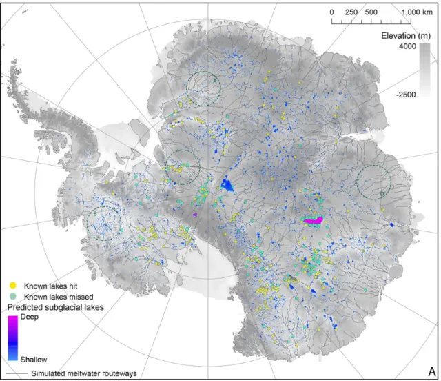
The subglacial drainage pattern produced for the BEDMAP2 dataset (grid size of 1 km) is displayed in Fig. 1a, and pro-vides an update of the work presented by Wright et al. (2008), which used BEDMAP (grid size of 5 km). Meltwa-ter flow is arranged in a series of discrete catchments, with meltwater flowing from central ice divides towards the mar-gin. Drainage networks reveal subtle variations in their ge-ometry. These can be characterised as (i) classical dendritic; (ii) angular; (iii) convergent; and (iv) parallel patterns (see inset circles in Fig. 1a). Subglacial meltwater tends to be concentrated along the major ice streams where the ice sur-face is lower than the surrounding ice sheet. Of the known subglacial lakes, the largest, Subglacial Lake Vostok (East Antarctica), is shown to drain through the Transantarctic Mountains (Fig. 1a).
Fig. 1
S. J. Livingstone et al.: Potential subglacial lake locations and drainage pathways 1725
Fig. 1.Simulated subglacial drainage pathways and subglacial lakes beneath the AIS.(A)Warm-based thermal regime. The four dark-green dotted circles illustrate the different types of drainage pattern (after Twidale, 2004) that characterise the bed of Antarctica (A: classical dendritic; B: angulate; C: convergent; and D: parallel). The simulated drainage networks are visually defined as cells which have more than 5000 cumulative cells flowing into them.
cases much reduced (e.g. subglacial lakes associated with the Recovery Glacier).
Fig. 5
Simulated subglacial lakes are relatively commonplace, with 12 767 occurring over ∼4 % of the grounded AIS (Fig. 1a, Table 1), dropping to 9 360 and 2.7 % respectively when cold-bedded regions are masked out (Fig. 1b, Table 1). They are prevalent beneath the East and West Antarctic ice sheets, occurring at a range of scales and congregating be-neath ice streams and ice divides, often along or at the source of major subglacial drainage routeways. Rugged regions of the bed display a greater tendency towards ponding, as do lo-calities where the ice-surface has a rough texture; the curvi-linear distribution of simulated subglacial lakes inland of the Transantarctic Mountains is primarily a result of such rough surface structure. The largest subglacial lakes are observed beneath ice divides, with the largest located close to the
South Pole and second-largest successfully delimiting Sub-glacial Lake Vostok (Fig. 1a). In contrast, they are relatively rare beneath the rugged Antarctic Peninsula hinterland where they typically form small lakes.
Of the known subglacial lakes, 61 % are successfully re-called using the Shreve equation, rising to 79 % when just those known lakes ≥5 km long are considered (Table 1; Fig. 1a). The most successful recall of known subglacial lakes occurs along the Siple Coast, in Victoria Land and down the Academy and Recovery glaciers, with the poorest recalls associated with the cluster of lakes around Subglacial Lake Vostok, south of 86◦
1726 S. J. Livingstone et al.: Potential subglacial lake locations and drainage pathways
Fig. 1. (B)Polythermal basal thermal regime (from Pattyn, 2010). The blue colour illustrates regions below the pressure melting point. This is used as a simple mask to remove all subglacial lakes that fall within the cold-bedded zones. The simulated drainage networks are visually defined as cells which have more than 5000 cumulative cells flowing into them, with a secondary threshold of 2000 cells (finer lines).
lakes are included, rising substantially (>65 %) when just analysing the known lakes≥5 km long (Table 1).
Given the high frequency of potential subglacial lake loca-tions (Table 1) it is conceivable the high recalls could occur by chance. In other words, the large number of potential sub-glacial lake locations may preclude a low percentage of hits because they occupy a large expanse of the ice-sheet bed. To test this we randomly redistributed the 386 known subglacial lakes and recalculated the recall. Despite carrying out multi-ple iterations, significantly lower percentages (30–35 %) are consistently recorded. This gives us confidence that the high recalls are real and not an artefact of chance.
For the same scenarios, we also looked at the precision of potential subglacial lake locations. This is more complicated because we do not have a complete inventory of subglacial lakes, and so a false-positive result does not preclude a cor-rect prediction. Of the 12 767 potential subglacial lake loca-tions predicted for the present-day ice sheet only 3.7 %
oc-cur within the buffer zone of known lake localities, with this figure rising to 3.9 % when subglacial lakes in cold-bedded regions of the AIS are masked out. This is comparable to the precision of both smoothing experiments (Table 1).
S. J. Livingstone et al.: Potential subglacial lake locations and drainage pathways 1727
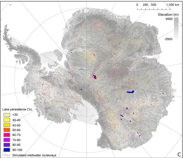
Fig. 1. (C)Subglacial lake persistence in response to 50 random bed elevation perturbation experiments, using a normal distribution with a standard deviation equal to the vertical bed elevation uncertainty. The simulated drainage networks are visually defined as cells which have more than 5000 cumulative cells flowing into them.
the recall remains high (58 % and 76 % with known lakes ≥5 km long), while the precision increases to 5 %. Higher lake persistence values result in a sharp fall in recall. For in-stance, those simulated subglacial lakes with a≥90 % per-sistence recall just 16 % of the known subglacial lakes.
3.2 Deglaciation of the Antarctic Ice Sheet since the LGM
Figure 2 reveals the simulated drainage patterns and potential subglacial lake locations at 20, 15, 10 and 5 thousand year time slices during the deglaciation of the AIS. These sug-gest that meltwater drainage under the AIS was relatively sta-ble throughout deglaciation thus far, with drainage configu-rations comparable to the present-day ice sheet (see Fig. 1a). However, significant meltwater switches and drainage cap-ture are observed. For instance, meltwater flow from Sub-glacial Lake Vostok, which is currently thought to drain through the Transantarctic Mountains (Fig. 1a), is simulated
to drain towards Wilkes Land during the four deglacial time slices (Fig. 2). Furthermore, the Siple Coast drainage net-work repeatedly shifted position as ice retreated (see Fig. 3). Indeed, at the 15 000 yr time-slice meltwater was cap-tured and focused through a single pass in the Transantarc-tic Mountains, while at 20 and 10 thousand years before present two major drainage routeways were thought to have been in operation (Fig. 3). By 10 000 yr ago, the western-most drainage network (basin 1 in Fig. 3) had been alwestern-most completely subsumed by its neighbouring catchment, and by 5000 yr before present West Antarctica was providing the majority of the meltwater instead of East Antarctica, which previously dominated.
1728 S. J. Livingstone et al.: Potential subglacial lake locations and drainage pathways
Fig. 2.Simulated subglacial drainage pathways and subglacial lakes at 5, 10, 15 and 20 thousand-year time slices during the deglaciation of the AIS. The ice-sheet model used is from Whitehouse et al. (2012).
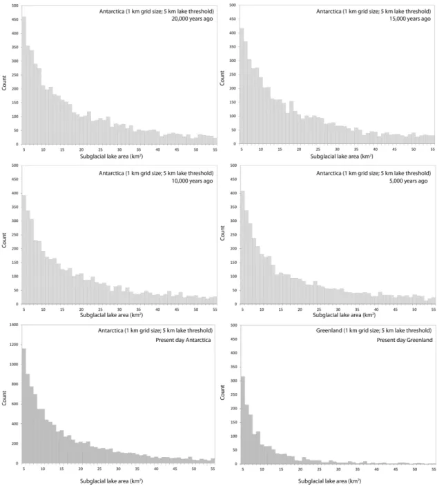
continental shelf and through the Transantarctic Mountains (Fig. 2). The frequency distribution of simulated subglacial lake areas is similar for all four deglacial time slices and a similar pattern if also observed for the present-day ice-sheet configuration (Fig. 4). Although very large subglacial lakes, greater than 300 km2, are simulated, the vast majority are<10 km2in size. This pattern is comparable to the distri-bution of known subglacial lake lengths (Wright and Siegert, 2012).
4 Simulating subglacial meltwater drainage and lakes under the Greenland Ice Sheet
Whereas subglacial lakes are commonly observed and simu-lated beneath the AIS (e.g. Wright and Siegert, 2012), there is almost no evidence for subglacial lakes existing beneath the GrIS (although see Ekholm et al., 1998). This seems incon-gruous given observations detailing the widespread presence of subglacial meltwater at its bed (Dahl-Jensen et al., 2003; Oswald and Gogineni, 2008, 2012). Is this because there are
very few subglacial lakes? If so, what conditions inhibit their formation? Or are there subglacial lakes at the bed that re-main to be found?
Given the high percentage of known subglacial lakes re-called beneath the AIS (Sect. 3) we suggest that simple hydrological calculations can be a useful tool for simulat-ing subglacial lakes and drainage pathways beneath other (palaeo-)ice sheets. With this in mind, we now investigate the subglacial drainage network of the GrIS in its present and past states, including the potential for subglacial lake forma-tion.
4.1 Present-day Greenland Ice Sheet
S. J. Livingstone et al.: Potential subglacial lake locations and drainage pathways 1729
Fig. 3.Simulated subglacial drainage pathways and lakes at 5, 10, 15 and 20 thousand-year time slices during the deglaciation of the Siple Coast sector of the AIS. The ice-sheet model used is from Whitehouse et al. (2012). The bar charts illustrate the area of significant drainage basins and correspond to the numbering on the maps. The pale-green lines divide drainage basins.
Like Antarctica, meltwater drainage beneath the GrIS is organised into a series of discrete catchments composed of dendritic pathways that broadly flow from the ice-sheet cen-tre to the margin (Fig. 5). Meltwater flow concentration is demonstrated along the fast-flowing corridors of the ice sheet, with significant drainage networks feeding the North-east Greenland Ice Stream (NEGIS) (108 925 km2), Jak-boshavn Isbrae (103 575 km2) and the Petermann Glacier (61 850 km2) (Fig. 5b). A qualitative relationship is also ob-served between ice-surface velocity and the size of the melt-water drainage network. Moreover, a good general agreement between predicted and known meltwater outlets was demon-strated by Lewis and Smith (2009) (Fig. 5a).
The Shreve equation simulates 1 607 subglacial lakes be-neath the GrIS, which cover∼1.2 % of the GrIS bed. The majority of lakes, particularly the larger ones, tend to oc-cur in the rugged eastern sector of the ice sheet, although they are also prevalent along the NEGIS, Jakobshavn Isbrae
and Helheim catchments and beneath the main north–south ice divide (Fig. 5). The overall distribution of potential sub-glacial lake locations displays a striking similarity to the AIS (Fig. 4), although very large subglacial lakes are not pro-duced.
1730 S. J. Livingstone et al.: Potential subglacial lake locations and drainage pathways
Fig. 4.The frequency distribution of potential subglacial lake areas. Bins of 1 km2are used and the maximum area is capped at 55 km2. Larger lakes such as Subglacial Lake Vostok exist, but these would skew the graph adversely and so are left off for simplicity.
4.2 Deglaciation of Greenland Ice Sheet since the Last Glacial Maximum
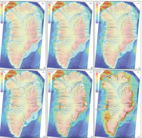
Like Antarctica, meltwater drainage under the GrIS is pre-dicted to have been broadly stable, with little large-scale re-organisation in hydrology since the LGM (Fig. 6). How-ever, subtle switches in subglacial water drainage are still demonstrated (Fig. 6). For instance, in western Greenland the northern limb of the Jakobshavn drainage network was captured by the Uummannaq system 16 000 yr ago, and the NEGIS drainage catchment expanded southwards during the
10 000 yr time slice (Fig. 6). Also, between 12 and 11 thou-sand years ago drainage pathways beneath the north GrIS, which previously (and subsequently) were orientated NW and NE, shift to transport water westwards (Fig. 6).
ter-S. J. Livingstone et al.: Potential subglacial lake locations and drainage pathways 1731
Fig. 5.Simulated subglacial drainage pathways and subglacial lakes beneath the GrIS.(A)Illustrates the relationship between ice-sheet topography and observed hydrological outlets (from Lewis and Smith, 2009).
rain, both along the eastern sector of the ice sheet and within fjords (Fig. 7a). Between 19 and 11 thousand years ago
>40 % of the simulated lakes are located beyond the present ice-margin position. Lakes are typically small and unstable during the last deglaciation.
Figure 8a demonstrates a decrease in the area covered by subglacial lakes concomitant with a reduction in GrIS size. The period of greatest ice recession, between 14 and 10 thou-sand years ago, is associated with the largest reduction in subglacial lakes (Fig. 8a). However, the change in subglacial lake area does not decline linearly with ice-sheet size. This is illustrated by the decline in the percentage of the ice-sheet bed occupied by subglacial lakes as the ice ice-sheet waned (Fig. 8b).
5 Interpretation and discussion
5.1 Antarctica
5.1.1 Recall of known subglacial lakes
1732 S. J. Livingstone et al.: Potential subglacial lake locations and drainage pathways
Fig. 5. (B)Simulated subglacial drainage pathways and subglacial lakes, and the relationship with ice-surface velocity (Joughin et al., 2010). The six largest drainage catchments (DC) are also listed.
lake-surface reflector into the BEDMAP2 topography grid. We suggest two reasons why this might be the case. Firstly, a subglacial lake would have to be filled to its hydraulic po-tential surface lip to fully smooth out the minima. While this might be the case for a few subglacial lakes that are just about to drain, the majority are likely to be at some inter-mediate state of filling (e.g. Smith et al., 2009, and refer-ences therein). It is therefore this extra space left to fill up before draining that we are mapping. Secondly, because of the coarse resolution of the grid (1 km or greater) lake out-lets may become smoothed, therefore artificially raising the depth required to trigger drainage. Raising the base level at which drainage may occur by smoothing the topography would, however, also pick out basins not able to host sub-glacial lakes, leading to over-predictions (see Sect. 5.1.2).
S. J. Livingstone et al.: Potential subglacial lake locations and drainage pathways 1733
Fig. 5. (C)Subglacial lake persistence in response to 50 random bed elevation perturbation experiments, using a normal distribution with a standard deviation equal to the vertical bed uncertainty.
The decline in recall when there is an increase in sub-glacial lake persistence over a threshold of∼60 % may rep-resent a range of lake sensitivities, and may therefore be a proxy for lake stability. For instance, the deep, tectonically controlled Subglacial Lake Vostok is recalled during every bed elevation perturbation experiment and is therefore likely to be very insensitive to future changes in ice surface or bed slope. Subglacial Lake Vincennes conversely is recalled
<80 %, which is probably because, despite being wide, it is also formed in a large basin characterised by low relief (Tabacco et al, 2006) and so may be more readily affected by bed or ice-surface elevation changes.
5.1.2 Precision of potential subglacial lake locations
The precision of the potential subglacial lake locations is sig-nificantly lower (<5 %) than the recall due to the large num-ber of false-negative results. This could be due to (i) error in the input datasets; (ii) many subglacial lakes that remain to be discovered; or (iii) the effect of processes not included in our simple model, e.g. spatial and temporal variations in effective water pressure and ice–hydrology coupling.
1734 S. J. Livingstone et al.: Potential subglacial lake locations and drainage pathways
Fig. 6.Simulated drainage networks and subglacial lakes for six time slices (A–F) through the evolution of the GrIS since the LGM. Ice surfaces are derived Simpson et al. (from 2009). The opaque white colour delimits the extent of the ice sheet, the blue lines show predicted meltwater pathways and the dark-blue colour shows subglacial lake locations. The red circles highlight drainage switches.
an incomplete knowledge of the bed, and in particular be-cause of erroneous subglacial lakes associated with gridding artefacts (Fig. 1). This is demonstrated by the results of our bed perturbation experiments (Fig. 1c). In regions of the bed characterised by limited or no data (see Fretwell et al., 2013) the majority of lakes occur infrequently (<50%) when the bed is randomly perturbed. Indeed, removing all simulated subglacial lakes that persist for less than half the perturbation experiments increases the precision to 5% without signifi-cantly altering the recall, which implies most of these lakes are artefacts of limited data availability or the interpolation method and can be ignored. Conversely those subglacial lake locations that persist through a large number of random per-turbations are insensitive to the bed elevation uncertainty and are therefore more likely to be real.
The large number of potential subglacial lake locations, which persist through a large number (>60%) of random
perturbations (Figs. 1c, 4), hints at the possibility of many small subglacial lakes yet to be found. However, it is diffi-cult to discriminate between the two remaining error terms without validation of the results against radar data.
5.1.3 Potential subglacial lake locations during the deglaciation of the Antarctic Ice Sheet
S. J. Livingstone et al.: Potential subglacial lake locations and drainage pathways 1735
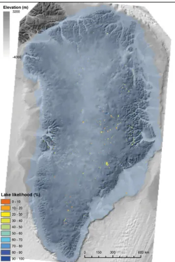
Fig. 7.Subglacial lake likelihood map. The likelihood is the per-centage time that subglacial lakes occurred in the same location while ice covered that region during deglaciation thus far (not in-cluding the present day). Those lakes with a high likelihood are therefore relatively stable.
The ice-surface flattening feedback resulting from sub-glacial lake formation (e.g. Livingstone et al., 2012, and references therein) sets up the intriguing possibility that many of the present-day subglacial lakes have been inher-ited from past ice-sheet configurations, and would have al-ready drained without this stabilising feedback. Such an ex-ample of hysteresis implies that, for the same geometry, a re-treating ice sheet yields considerably more subglacial lakes than one advancing. It therefore follows that many subglacial lakes formed during the last deglaciation, under different ice-sheet geometries, still exist beneath the present-day AIS. The results displayed in Table 2 support this, with 41–44 % of the known subglacial lakes successfully recalled during each deglacial time slice, rising to 50 % when they are all included. Smoothing the ice surface should remove inher-ited subglacial lakes whose existence depends on the ice-surface flattening feedback. Indeed, there is 25 % less chance
Fig. 8. (A)Scatter graph showing the predicted total subglacial lake area vs. the area of the GrIS and colour-coded according to time slice (ka); and(B)the fraction of the grounded ice-sheet bed oc-cupied by subglacial lakes vs. ice-sheet area. The trend line in plot A is an exponential curve that generates anR2of 0.99.
of recalling a known subglacial lake when the ice surface has been smoothed and 23 % less chance when using the modelled present-day output (Table 1). We can test whether the subglacial lakes, which have been smoothed out, were derived from past ice-sheet configurations by summing the smoothed subglacial lake simulations with those from the deglacial time slices (see Table 2). The result is a 13 % and 14 % increase in the ability to recall known subglacial lakes using the smoothed and modelled outputs respectively, com-pared to 8 % when summing the standard experiment with the deglacial time slices (Table 2). This first-order approxi-mation implies that the deglacial simulations can account for ∼13−14 % of the known subglacial lakes and that 5–6 % of subglacial lakes persist solely due to the ice-surface flatten-ing feedback.
1736 S. J. Livingstone et al.: Potential subglacial lake locations and drainage pathways
Fig. 9.Bed and ice surface profiles for the Greenland and Antarctic ice sheets. Profiles correspond to the inset images of the two ice sheets and both the vertical and horizontal scales are the same for all profiles. Note how the smaller Greenland Ice Sheet has much steeper overall slopes than the Antarctic Ice Sheet, which, because of its size, is characterised by large swathes of relatively flat regions in the interior.
unknown. Certainly, this work suggests that subglacial lakes are more pervasive (and therefore of greater importance) dur-ing the deglacial phase, which has resonance for ice-stream formation and flow, bed lubrication, meltwater drainage and eventually ice-sheet collapse.
5.1.4 Meltwater drainage pathways
Our simulated meltwater drainage pathways form a broadly similar network to that calculated by Wright et al. (2008). Variations in drainage patterns between different regions of Antarctica’s bed (Fig. 1a) are thought to reflect underlying controls on glacial processes such as slope and structure (cf. Twidale, 2004, and references therein). Classical dendritic patterns are typically associated with very slight surface slopes and/or regions with no significant structural control. It is therefore no surprise that this pattern characterises many of the interior zones of East Antarctica where ice-surface slopes were very low, and regions of the bed smoothed due to lack of data (Fig. 1a). In West Antarctica, especially in-land of the Amundsen Sea, and south of the Transantarctic
Mountains, drainage patterns are more angular, possibly due to the basal geology (e.g. the arrangement and spacing of faults and joints). The strongly convergent pattern of melt-water drainage from the South Pole into the Ronne Ice Shelf could reflect the former breaching of a large bedrock ridge, with the subsequent lowering of the drainage level leading to capture of the surrounding hydrology. Finally, strongly par-allel drainage geometries imply control of flow by gradient, which is in agreement with the ice-marginal drainage pattern where ice-surface slopes are greatest (Fig. 1a).
S. J. Livingstone et al.: Potential subglacial lake locations and drainage pathways 1737
Table 2.Ice-surface flattening feedback and subglacial lake inher-itance: the second to fifth rows illustrate the percentage of known subglacial lakes recalled by each of the modelled deglacial time slices (20, 15, 10 and 5 thousand year intervals). The sixth row is the percentage of known subglacial lakes recalled by the summed deglacial time slices, the seventh row is the percentage recall of the summed deglacial time slices combined with the present-day ice sheet, and the final two rows combine the summed deglacial time slices with the smoothed and modelled present-day ice surfaces re-spectively. See text for detailed explanation.
Data Recall (percentage)
Present day (from Table 1) 61
5000 yr ago 41
10 000 yr ago 41
15 000 yr ago 41
20 000 yr ago 44
All deglacial intervals 50 Present day and all 69 deglacial time intervals
Smoothed present-day ice surface and 52 all deglacial time intervals
Present-day modelled ice surface and 49 all deglacial time intervals
and cold-based ice to form the freeze-on plumes observed in radar data (Bell et al., 2011).
Wright et al. (2008) demonstrate that hydrological flow directions can be highly sensitive to slight changes in ice-surface topography. And although the broad-scale pattern of meltwater flow during the last deglaciation is predicted to have been relatively stable (Fig. 2), we also note sev-eral regions susceptible to drainage capture or migration, which are moreover shown to be sensitive to perturbations of the present-day ice surface by smoothing. For instance, we observe a similar sensitivity in the drainage of Subglacial Lake Vostok during deglaciation (cf., Wright et al., 2008), while the Siple Coast drainage configuration is shown to have shifted repeatedly during deglaciation using the mod-elled output (Fig. 3). This is probably due to the low an-gle of ice slope, which leaves the neighbouring ice-stream drainage networks vulnerable to minor changes in ice thick-ness. It is perhaps no surprise then that ice-stream stagna-tion interpreted to indicate meltwater capture has been ob-served between two of the contemporary ice streams in this region (Anandakrishnan and Alley, 1997). Our analysis sug-gests this may have been a common occurrence during the last deglaciation, which is in agreement with studies that in-fer dynamic variability in the behaviour of the Siple Coast ice streams over millennial timescales (Conway et al., 1999; Catania et al., 2012).
5.2 Greenland
5.2.1 Subglacial lakes beneath the present-day Greenland Ice Sheet
The results for Greenland indicate the potential for subglacial lake formation at the base of the ice sheet, particularly in the rugged eastern sector and beneath major ice streams such as the NEGIS and Jakobshavn Isbrae (Fig. 5). The possibility of subglacial lake formation is further supported by the bed per-turbation experiments (Fig. 5c), which indicate persistence of many of the potential subglacial lake locations within the range of bed uncertainty. The analysis therefore implies that, whilst few subglacial lakes have been found beneath the GrIS to date, the ice and bed topographies do permit lake forma-tion (see also Livingstone et al., 2012). We therefore predict that it is only a matter of time before a network of subglacial lakes is identified beneath the GrIS and that our potential sub-glacial lake locations (both present day and during deglacia-tion) may provide useful targets for geophysical studies to discover lakes. This is demonstrated by the successful recall of an ice-surface depression anomaly in northern Greenland, inferred to indicate subglacial lake formation, using our sub-glacial lake predictions (Ekholm et al., 1998).
Apart from the paucity of very large subglacial lakes be-neath the GrIS the size, frequency and distribution of lakes are remarkably similar to the AIS (Figs. 1, 4, 5). However, there is a reduced potential for subglacial lake formation be-neath the present-day GrIS (∼1.2 % of bed area) compared to the AIS (4%). This leads us to deduce that the bed and ice-surface geometry of the GrIS is less conducive to subglacial lake formation and therefore that subglacial lakes are a less significant component of the hydrological network compared to the AIS. Since the influence of the ice surface on hydraulic potential is about ten times that of the bed (e.g. Shreve, 1972), the lack of subglacial lakes can be reconciled with the steep ice-surface gradients of the GrIS compared to the AIS (see Fig. 9). Thus, the substantially smaller size of the GrIS results in steeper mean surface slopes, thereby precluding an extensive present-day subglacial lake network. This conclu-sion is supported by Pattyn (2008), who used a full Stokes model to demonstrate the decisive influence of mean-surface slope on subglacial lake stability.
5.2.2 Subglacial lake evolution during the deglaciation of the Greenland Ice Sheet
1738 S. J. Livingstone et al.: Potential subglacial lake locations and drainage pathways
is therefore that the GrIS has lost subglacial lakes through drainage since the LGM (Pattyn (2008); Fig. 9). In addition, Fig. 8b demonstrates how the percentage of the ice-sheet bed occupied by subglacial lakes changed more rapidly (i.e. the gradient was steeper) during the initial stages of deglaciation (19–10 thousand years ago) when the ice sheet was larger (Fig. 8b). This implies that subglacial lakes are more sensi-tive to changes in ice-sheet size when the ice sheet is larger (i.e. for a given change in ice-sheet area the change in sub-glacial lake extent is of a higher magnitude).
When the GrIS had expanded onto the continental shelf (19–11 thousand years ago)>40 % of the simulated sub-glacial lakes lay outside of the present-day ice margin, and would therefore have emerged from under the ice. Other lakes that formed within the bounds of the present-day ice sheet, but are predicted to have drained (Fig. 8) may have survived deglaciation due to the ice-surface flattening feed-back (see Sect. 5.1.3).
5.2.3 Meltwater drainage routeways
The dendritic pattern of subglacial meltwater flow pathways simulated in this study (Fig. 5) is consistent with the re-sults of Lewis and Smith (2009), and also broadly similar in form to that simulated beneath the AIS. The simulated evolution of the subglacial drainage network since the LGM (Fig. 6) demonstrates the susceptibility of some localities of the ice sheet to subglacial drainage switches, driven by subtle changes in ice surface and bed geometry. Significantly, some of the major present-day ice streams, such as NEGIS and Jakobshavn, display significant changes to their subglacial water flow paths over time (Fig. 6). As for Antarctica, we predict drainage shifts could play a crucial role in control-ling ice streaming and behaviour.
6 Conclusions
We have demonstrated that the Shreve hydraulic potential equation and simple routing mechanisms in a GIS can be used to successfully recall a high percentage (>60 %) of the known subglacial lakes beneath the AIS. This is despite the surfaces of existing subglacial lakes being used to calculate the bed topography and ice thicknesses used in the calcu-lations. We reason this is because most lakes are not com-pletely full (i.e. at intermediate states of filling) and the rel-atively coarse grid resolution smooths out the base level at which drainage may occur. In particular, the larger subglacial lakes are easier to recall, although these make up only a small percentage of the total number of lakes.
We simulate significantly more subglacial lakes than those presently identified beneath the AIS, resulting in a low pre-cision. Such a discrepancy is thought to primarily stem from an incomplete knowledge of the bed, as demonstrated by the low frequency of persistent subglacial lakes in regions char-acterised by large bed elevation uncertainties. And although
our use of a simple hydrological model not coupled to ice dynamics undoubtably ignores some important mechanisms, we suggest that hundreds if not thousands of subglacial lakes, particularly smaller ones, are yet to be found beneath the AIS. These potential subglacial lake locations provide use-ful targets for future radar surveys.
By applying the same method to the GrIS we demon-strate the potential for subglacial lake formation at its bed. However, in contrast to Antarctica the subglacial lakes are shown to occupy a smaller fraction of the grounded ice-sheet bed and are characteristically small features. We sug-gest this is a result of steeper mean surface gradients con-comitant with a smaller ice sheet (Figs. 8 and 9). Finally, we demonstrate that many present-day subglacial lakes have been inherited from past ice-sheet configurations due to the subglacial lake ice-surface flattening feedback, and would have already drained without this stabilising effect. The re-sultant hysteresis, whereby a retreating ice sheet will have many more subglacial lakes than one advancing, has implica-tions for ice-stream formation and flow, bed lubrication and meltwater drainage.
Modelling the present-day drainage networks beneath the Antarctic and Greenland ice sheets has elucidated major meltwater pathways and the form they take. In Antarctica dendritic, angular, convergent and parallel drainage pathways have all been simulated, which have been related to under-lying (ice and bed) slope and structural controls. The evo-lution of the Greenland and Antarctic subglacial drainage networks were assessed by simulating basal meltwater flow at discrete time intervals over the last 21 000 yrs. We re-veal key sectors of the two ice sheets that have been vul-nerable to past drainage switches. In particular, neighbour-ing ice-stream drainage networks (e.g. the Siple Coast sec-tor, AIS and the NEGIS, Greenland) with their low-angled slopes are shown to be particularly sensitive to small changes in ice geometry.
Finally, the predictability of subglacial lakes beneath the AIS using hydraulic potential equations and routing tech-niques suggests this is also a viable methodology for ex-ploring potential palaeo-subglacial lake locations beneath the great Quaternary Northern Hemisphere ice sheets (see Evatt et al., 2006; Livingstone et al., 2013). This approach has the benefit of comprehensive information on the bed properties, but relies on modelled ice-surface topographies.
Acknowledgements. This work was supported by a NERC Early Career Research Fellowship awarded to SJL (NE/H015256/1). The data are available upon request from the lead author. We thank Matt Simpson, Pippa Whitehouse and Frank Pattyn for supplying ice-sheet model output on the deglaciation of the Greenland Ice Sheet and Antarctic Ice Sheet, and modelled basal temperature data respectively. The manuscript has benefitted greatly from the comments of two anonymous reviewers and Sasha Carter.
S. J. Livingstone et al.: Potential subglacial lake locations and drainage pathways 1739
References
Anandakrishnan, S. and Alley, R. B.: Stagnation of Ice Stream C, West Antarctica by water piracy, Geophys. Res. Lett., 24, 265– 268, 1997.
Anderson, J. B. and Oakes-Fretwell, L.: Geomorphology of the on-set area of a palaeo-ice stream, Marguerite Bay, Antarctic Penin-sula, Earth Surf. Proc. Land., 33, 503–512, 2008.
Bamber J. L., Layberry, R. L., and Gogineni, S. P.: A new ice thick-ness and bed data set for the Greenland Ice Sheet: 1. Measure-ment, data reduction, and errors, J. Geophys. Res., 106, 33773– 33780, 2001a.
Bamber J. L., Layberry, R. L., and Gogineni, S. P.: A new ice thick-ness and bed data set for the Greenland Ice Sheet: 2. Relationship between dynamics and basal topography, J. Geophys. Res., 106, 33781–33788, 2001b.
Bamber J. L., Griggs, J. A., Hurkmans, R. T. W. L., Dowdeswell, J. A., Gogineni, S. P., Howat, I., Mouginot, J., Paden, J., Palmer, S., Rignot, E., and Steinhage, D: A new bed el-evation dataset for Greenland, The Cryosphere 7, 499–510, 2013. Bartholomew, I., Nienow, P., Mair, D., Hubbard, A., King, M. A., and Sole, A.: Seasonal evolution of subglacial drainage and ac-celeration in a Greenland outlet glacier, Nat. Geosci., 3, 408–411, 2010.
Bell R. E., Ferraccioli, F., Creyts, T.,T., Braaten, D., Corr, H., Das, I., Damaske, D., Frearson, N., Jordan, T., Rose, K., Studinger, M. and Wolovick, M.: Widespread persistent thick-ening of the East Antarctic Ice Sheet by freezing from the base, Science, 331, 1592–1595, 2011.
Catania, G., Hulbe, C., Conway, H., Scambos, T. A. and Ray-mond, C. F.: Variability in the mass flux of the Ross ice streams, West Antarctica, over the last millennium, J. Glaciol., 58, 741– 752, 2012.
Clarke, G. K. C.: Subglacial processes, Ann. Rev. Earth Planet. Sci., 33, 247–276, 2005.
Conway, H., Hall, B. L., Denton, G. H., Gades, A. M., and Wadding-ton, E. D.: Past and future grounding-line retreat of the West Antarctic Ice Sheet, Science, 286, 280–284, 1999.
Cuffey, K. M. and Patterson, W. S. B.: The Physics of Glaciers, 4th Edn., Elsevier, 2010.
Dahl-Jensen, D., Gundestrup, N., Gogineni, S. P., and Miller, H.: Basal melt at NorthGRIP modelled from borehole, ice-core and radio-echo sounder observations, 37, 207–212, 2003.
Domack, E., Amblás, D., Gilbert, R., Brachfield, S., camer-lenghi, A., Rebesco, M., Canals, M., and Uregeles, R.: Subglacial morphology and glacial evolution of the Palmer deep outlet sys-tem, Antarctic Peninsula, Geomorphology, 75, 125–142, 2006. Ekholm, S., Keller, K., Bamber, J. L. and Gogineni, S. P.: Unusual
surface morphology from digital elevation models of the Green-land Ice Sheet, Geophysical Research Letter, 25, 3623–2626, 1998.
Evatt, G. W., Fowler, A. C., Clark, C. D., and Hulton, N. R. J.: Subglacial floods beneath ice sheets, Philos. T. Roy. Soc. A, 374, 1769–1794, 2006.
Fountain, A. G. and Walder, J. S.: Waterflow through temperate glaciers, Rev. Geophys., 36, 299–328, 1998.
Fretwell, P., Pritchard, H. D., Vaughan, D. G., Bamber, J. L., Bar-rand, N. E., Bell, R., Bianchi, C., Bingham, R. G., Blanken-ship, D. D., Casassa, G., Catania, G., Callens, D., Conway, H., Cook, A. J., Corr, H. F. J., Damaske, D., Damm, V.,
Fer-raccioli, F., Forsberg, R., Fujita, S., Gim, Y., Gogineni, P., Griggs, J. A., Hindmarsh, R. C. A., Holmlund, P., Holt, J. W., Jacobel, R. W., Jenkins, A., Jokat, W., Jordan, T., King, E. C., Kohler, J., Krabill, W., Riger-Kusk, M., Langley, K. A., Leitchenkov, G., Leuschen, C., Luyendyk, B. P., Matsuoka, K., Mouginot, J., Nitsche, F. O., Nogi, Y., Nost, O. A., Popov, S. V., Rignot, E., Rippin, D. M., Rivera, A., Roberts, J., Ross, N., Siegert, M. J., Smith, A. M., Steinhage, D., Studinger, M., Sun, B., Tinto, B. K., Welch, B. C., Wilson, D., Young, D. A., Xiangbin, C., and Zirizzotti, A.: Bedmap2: improved ice bed, surface and thickness datasets for Antarctica, The Cryosphere, 7, 375–393, doi:10.5194/tc-7-375-2013, 2013.
Fricker, H. A., Scambos, T., Bindschadler, R., and Padman, L.: An active subglacial water system in West Antarctica mapped from space, Science, 315, 1544–1548, 2007.
Fricker, H. A., Scambos, T., Carter, S., Davis, C., Haran, T. and Joughin, I.: Synthesizing multiple remote-sensing techniques for subglacial hydrologic mapping: application to a lake system be-neath MacAyeal Ice Stream, West Antarctica, J. Glaciol., 56, 187–199, 2010.
Hallet, B.: Subglacial regelation water film, J. Glaciol., 17, 209– 221, 1979.
Hubbard, B., Sharp, M. J., Willis, I. C., Neilsen, M. K., and Smart, C. C.: Borehole water-level variations and the structure of the subglacial hydrological system of Haut Glacier d’Arolla, Valais, Switzerland, J. Glaciol., 41, 572–583, 1995.
Joughin, I., Smith, B. E., Howat, I. M., Scambos, T., and Moon, T.: Greenland flow variability from ice-sheet wide velocity map-ping, J. Glaciol., 56, 415–430, 2010.
Kamb, B.: Glacier surge mechanism based on linked cavity config-uration of the basal water conduit system, J. Geophys. Res., 96, 585–595, 1987.
Kamb, B.: Basal zone of the West Antarctic ice streams and its role in lubrication of their rapid motion, in: The West Antarctic Ice Sheet: behaviour and environment, edited by: Alley, R. B. and Bindschadler, R. A., Antarctic Research Series, 77, Washington DC, American Geophysical Union, 157–199, 2001.
Kingslake, J. and Ng, F.: Modelling the coupling of flood discharge with glacier flow during jökulhlaups,Annals of Glaciology, 54, 25–31, 2013.
Lappegard, G., Kohler, J., Jackson, M., and Hagen, J. O.: Charac-teristics of subglacial drainage systems deduced from load-cell measurements, J. Glaciol., 52, 137–148, 2006.
Lewis, S. M. and Smith, L. C.: Hydrological drainage of the Green-land Ice Sheet, Hydrol. Process., 23, 2004–2011, 2009. Livingstone, S. J., Clark, C. D., Piotrowski, J. A., Tranter, M. J.,
Bentley, M. J. Hodson, A., Swift, D. A., and Woodward, J.: The-oretical framework and diagnostic criteria for the identification of palaeo-subglacial lakes, Quaternary Sci. Rev., 55, 88–110, 2012. Livingstone, S. J., Clark, C. D., and Tarasov, L.: Modelling North American palaeo-subglacial lakes and their meltwater drainage pathways, Earth Planet. Sci. Lett., 375, 13–33, 2013
Lliboutry, L.: Local friction laws for glaciers: a critical review and new openings, J. Glaciol., 23, 67–95, 1979.
1740 S. J. Livingstone et al.: Potential subglacial lake locations and drainage pathways
Oswald, G. K. A. and Gogineni, S. P.: Recovery of subglacial water extent from Greenland radar survey data, J. Glaciol., 54, 94–106, 2008.
Oswald, G. K. A. and Gogineni, S. P.: Mapping basal melt under the Northern Greenland Ice Sheet, IEEE T. Geosci. Remote, 50, 585–592, 2012.
Pattyn, F.: Investigating the stability of subglacial lakes with a full Stokes ice-sheet model, J. Glaciol., 54, 353–361, 2008. Pattyn, F.: Antarctic subglacial conditions inferred from a hybrid ice
sheet/ice stream model, Earth Planet. Sci. Lett., 295, 451–561, 2010.
Robin, G. de Q., Swithinbank, C. W. M., and Smith, B. M. E.: Radio Echo Exploration of the Antarctic Ice Sheet, International sym-posium on Antarctic glaciological exploration (ISAGE), Han-nover, New Hampshire, USA, 3–7 September 1968, 1970. Röthlisberger, H.: Water pressure in intra- and subglacial
chan-nels, J. Glaciol., 11, 177–203, 1972.
Rutt, I. C., Hagdorn, M., Hulton, N. R. J. and Payne, A. J.: The Glimmer community ice sheet model, J. Geophys. Res., 114, F02004, doi:10.1029/2008JF001015, 2009.
Schoof, C.: Ice-sheet acceleration driven by melt supply variability, Nature, 468, 803–806, 2010.
Sergienko, O. V. and Hulbe, C. L.: ’Sticky spots’ and subglacial lakes under ice streams of the Siple Coast, Antarctica, Annals of Glaciology, 52, 18–22, 2011.
Sharp, M., Gemmell, J. C., Tison, J.-L.: Structure and stability of the former subglacial drainage system of the Glacier de Tsanfleuron, Switzerland, Earth Surf, Proc. Land., 14, 119–134, 1989. Shreve, R. L.: Movement of water in glaciers, J. Glaciol., 11, 205–
214, 1972.
Siegert, M. J., Le Brocq, A., and Payne, A. J.: Hydrological con-nections between Antarctic subglacial lakes, the flow of water beneath the East Antarctic Ice Sheet and implications for sedi-mentary processes, in: Glacial Sedisedi-mentary Processes and Prod-ucts, edited by: Hambrey, M. J., Christoffersen, P., Glasser, N. F., and Hubbard, B., Special Publication 39 of the IAS, Wiley-Blackwell, 2007.
Simpson, M. J. R., Milne, G. A., Huybrechts, P., and Long, A. J.: Calibrating a glaciological model of the Greenland Ice Sheet from the Last Glacial Maximum to present-day using field ob-servations of relative sea level and ice extent, Quaternary Sci. Rev., 28, 1631–1657, 2009.
Smith, B. E., Fricker, H. A., Joughin, I. R., and Tulaczyk, S.: An in-ventory of active subglacial lakes in Antarctica detected by ICE-Sat (2003–2008), J. Glaciol., 55, 573–595, 2009.
Tabacco, I. E., Cianfarra, P., Forieri, A., Salvini, F. and Zirizotti, A.: Physiography and tectonic setting of the subglacial lake district between Vostok and Belgica subglacial highlands (Antarctica), Geophysical Journal International, 165, 1029–1040, 2006. Twidale, C. R.: River patterns and their meaning, Earth Sci. Rev.,
67, 159–218, 2004.
Walder, J. S. and Hallet, B.: Geometry of former subglacial water channels and cavities, J. Glaciol., 23, 335–346, 1979.
Whitehouse, P. L., Bentley, M. J., and Le Brocq, A. M.: A deglacial model for Antarctica: geological constraints and glaciological modelling as a basis for a new model of Antarctic glacial iso-static adjustment, Quaternary Sci. Rev., 32, 1–24, 2012. Wingham, D. J., Siegert, M. J., Shepherd, A., and Muir, S.:
Rapid discharge connects Antarctic subglacial lakes, Nature, 440, 1033–1036.
Wright A. P. and Siegert M. J.: A fourth inventory of Antarctic sub-glacial lakes, Antarctic Science, 24, 659–664.