Revista GEAMA
The Journal of environment
Revisão científica
A BRIEF HISTORY OF THE EVOLUTION OF SURVEYING AND
ITS ROLE IN TODAY’S WORLD
Rafael Silva dos Anjos
aa Researcher at the Master's Program in Geodetic Sciences and Geoinformation Technology from the Federal University of
Pernambuco – UFPE. Recife, PE, Brasil.
________________________________________________ *Corresponding author: anjos.rsa@gmail.com
ABSTRACT
The land surveying appeared millennia ago as a measurement technique for large human constructions. Before all its historical process that science has gone through phases of improvement that has become quite popular nowadays. Since the first measurement instruments as the Egyptian Groma to the use of theodolites and total stations integrated with all kinds of instruments of spatial data acquisition (GNSS receivers, aerial photographs, multispectral satellites) the surveying methods now form the basis for various types of research. Quite confused with other sciences, such as Geodesy, Topography makes a more limited planialtimetric survey. That is why their applications are given in areas such as civil engineering, architecture, agronomy to architecture. If we know the differentiation of these key concepts related to topography we can to understand the applicability of this science, helping researchers in various fields. It is in this context, that the present paper aims to address the main concepts related to topography and the main activities human using this technique, making a historical approach since the beginning of its use to the instruments most widely used in the survey.
INTRODUCTION
Throughout history, man has always sought to understand the space in which it was inserted. With this driving need, the techniques that seek to understand and manipulate the natural elements inserted in the space have been increasingly growing over the centuries
Considered for some researchers, as one of the defining moments in human evolution, the begining of the agriculture - about about 10,000 years ago - promoted a demand to improvement in planting techniques, with the change from a nomadic lifestyle to a sedentary life, giving rise to the necessary elements for the establishment of the first civilizations.
The consequence of agriculture were more food available, more people could enjoy the harvest, and thus, it creating a complexity in interpersonal relationships. It is in this scenario that arise all kinds of resource use that space could provide, from the manufacture of ceramic recipient to the use of minerals for the manufacture of various instruments (GEOFFREY, 2009).
This set of activities focused on a particular region allowed the formation of the first cities, which in turn, began to have their social level according to the function that the individual exercised. Regarded as one of the major civilizations in the ancient world,
Egypt constituted architects, astronomers,
engineers for more than 2000 years BC The need for massive constructions allowed to seek new methods of measurements as well as the improvement of the instruments used.
This need to understand the space has continued over the millennia. Thus, over the years, it allowed to describe, manipulate and to obtain advantage of the elements of the earth's surface. In this context,
know the area we live in is very important for human evolution, facilitating access to resources and highlighting the obstacles that the geographical space can provide.
With the needs of society, it was necessary to define and demarcate territories with the aim to have control over agricultural production, tax collection. For this, the land measurement methods were needed to make the land ownership records, and support in urban planning.
It is from this, that there is the topography: the science that seeks to measure accurately the planimetric and altimetric variations of the ground. However, his trajetory as a science is quite long, and their areas of application from the beginning has always been quite varied.
Given the above, it is proposed in current article to approach the main definitions of the topography, the history and all techno-scientific contribution to the various fields of human activities since the beginning to the present day.
REVIEW
1.
Definition
of
surveying
and
first
contributions to human activities
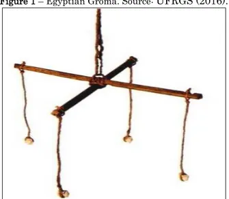
With the change of the human habit of nomadic life to sedentary, the growth of cities required an improvement in the land measurement techniques contributing to large scale buildings. The Egyptian
civilization already had rustic measuring
instruments such as the Egyptian Groma (Figure 1), which served to align the objects distributed on a flat surface for millennia ago.
Figure 1 – Egyptian Groma. Source: UFRGS (2016).
Besides the Egyptians, the Mesopotamians, after Chinese, Hebrews, Greeks and Romans used the first technical principles of topography. Although nobody knows the exact year that the topography began to be used, it is inferred that would be before 3200 A.C. (COELHO Jr et al., 2014).
For we understand how the topographic methods were quite helpful in Old Age, we cite the Roman aqueducts (Figure 2), which were large artificials channels that captured water from rivers taking it to the Roman metropolis. The channel of the course had to be carefully calculated for that the steepness of the aqueduct not be very high (for the velocity of water don't increase and damage their structure ) or very flat (for the flow of water don't stop) (DEMBSKEY 2009 ).
Figure 2 – Roman Aqueduct Água da Prata – Évora. Source: Author (2013).
Another contribution of the topography for the Romans was the demarcation of land to facilitate the registration process of the lots for the calculation of taxes. It is interesting to note that, during the Roman Empire, the romans began to map the land use using methods of measurement with own tools (DILKE, 1987).
The definition of what would be Topography is still widely debated among researchers. The word derives from the Greek language in which topo means place and graphy means description, thus signifying the description of the place (COELHO JR et al., 2014). It is worth noting that from the scientific point of view, the topography is the science of determining the dimensions and contours of the earth's surface, through distances, directions and altitudes (SILVA, 2013).
The concept of Topography is confused with other concepts for various reasons. By using virtually the same instruments for the mapping of the Earth's surface it is quite confused with the Geodesy. However, the difference of these two sciences is the scale worked where the topography maps portions of the Earth within a radius until 30 km (without taking into account the Earth's curvature), while Geodesy works with land portions higher (Brandalize, 2016).
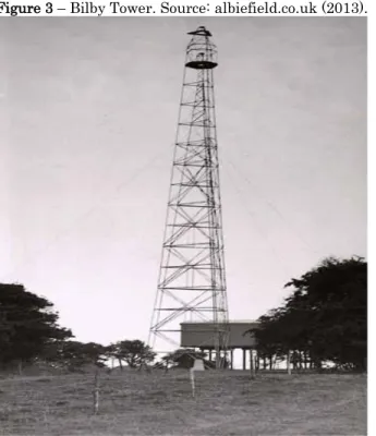
This confusion is explained because the same topography survey methods are used for the creation of geodetic networks. We can cite the geodetic networks of horizontal control that are materialized by trigonometric points by triangulation method. To execute the tasks at great distances from the total station / theodolite between the vertices of the network was necessary to use Bilby towers. With the emergence of GNSS it was no longer necessary this method (MARQUES, 2015).
Figure 3 – Bilby Tower. Source: albiefield.co.uk (2013).
Based on this definition, we have to emphasize the differentiation of terms coming topography regarding the nature of general cartographic representation, which in turn is divided into cadastral, topographic and geographic maps. In some cases Topographic maps are not made from
topographic methods, but also from
aerophotogrammetric survey, including
representation of planimetric and altimetric elements (IBGE, 2016).
In many cases, the topography is considered as representing the altitude of a delimited field. In this case, it is suggested the topography surface term that is the portion of the land surface lifted from topographic methods (Brandalize, 2016).
Despite being a science that began to be worked millennia ago, it is worth noting that it was developed considerably in recent centuries because of the technological development of measuring instruments. Regarded as one of the improvement of the landmarks of Topography in terms of mapping,
the first topographic map of the world is considered the Carte Géometric de la France completed in 1789 (Figure 3), that is considered the first sheet of a series of topographical maps of a country (LOC, 2016).
Figure 4 - Carte Géométric de la France. Souce: Loc (2016).
Throughout history of the topographic mapping, the techniques used in topography were complemented with aerial photographs in the early twentieth century. For Collier (2012) there were four phases of development data acquisition techniques for topographic mapping. The first phase, before the First World War, consisting of numerous experiments using new techniques, but with little impact on the mapmaking process. The second phase, during World War I, was characterized by simple topographical methods to meet the high demand of the military for topographic maps. The third phase, after World War I, started using aerial photography with civil mapping purposes. The fourth phase, from 1930, there was a wide use of photogrammetric methods, which were no longer considered more experiments but, more effective method for altimetry mapping of the region.
2. Evolution of surveying instruments and their role in the world today
2.1 Technological development of
instruments
The first instruments for surveying were based in principles of optical and mechanical science (Figure 4). In the twentieth century, these instruments had considerable technical level with the contributions of numerous scientists in several areas (Physics, Applied Geometry, Engineering, Mechanical, among others) allowing in obtaining spatial data more precise (UFBA, 2016).
Figure 5 - Mounting of theodolite in 1895. Source: Pinterest (2016).
Some accessories used in planialtimetric survey have not advanced considerably over the decades since its function had not needed an added sophistication. We can see like example the stakes and pickets, which are still used.
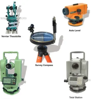
However, the instruments is having considerable advances over the decades and other have been inserted into planialtimetric survey. Among the main instruments that have evolved over the decades are measuring tape, theodolite, transit level. In addition, these that were added: Total Station and the receptors of the Global Navigation Satellite System (GNSS).
The modernization of these surveying
instruments due to the emergence and evolution of information technology and microelectronics. It was with this development that instruments such as theodolites (optical-mechanical instrument) - that were used more than 450 years - were gradually replaced by total stations. (UFBA, 2016).
Currently, the main instruments for surveying are (COELHO JÚNIOR et al., 2014):
• Total station: electronic instrument used to obtain angles, distances and coordinates used to plot a land area. This instrument is regarded as the theodolite substitute, that was added an electronic distancer, a temporary memory, a fixed memory and a connection with the computer.
• GNSS: Global Navigation Satellite System consists of several systems that provide the location of an object in X, Y and Z over the entire globe. The GNSS consists of several satellite constellations from various GPS countries (United States), GLONASS (Russia), Galileo (European Union).
• Theodolite: are instruments only
measurements of vertical and horizontal angles, they do not have the stadia lines.
• Transit levels: serves to measure vertical distances between two or more points.
Figure 6 - Instruments of Surveying. Source: Lokpal (2016).
The use of these surveying instruments allow that the result can be applied in several areas: engineering, monitoring of dams, assistance in preventing natural disasters such as floods and landslides. In addition, the types of data already in its digital format allows us to do all kinds of simulations involving areas in the water sector, climatic, geological, among others. Let us cite some examples below.
2.2 Main applications of Topography
currently
The topographic mapping may assist in identifying areas that are not correct from the point of view of environmental legislation. This may contribute not only to identify those areas, but also as a tool for conservation planning or protection of certain areas in accordance with environmental law.
Testoni and Backes (2009) evaluated the importance of topography in the recovery of degraded areas, managing to identify on a plot in the city of Laurentino, Santa Catarina, uneven areas from the current Forest Law.
From a surveying, Oliveira et al (2014) found irregularities in the terrain, which does not meet the New Environmental Legislation, drawn up in 2012, in the city of Presidente Prudente in São Paulo. To assess the accuracy of the level of flooding, by topographic methods, Greiner (2014) found that the linimétrica ruler in Lajeado-RS city was not adjusted to the level of the sea raising questions about the integration of levels of reference official with historical series linimétricas rules. These markup errors in the level of rivers hinders the process of modeling to assess areas susceptible to flooding. A major contribution of the topography for the environment is the 3D modeling of a region. From planialtimetric data collected in the field, we can interpolation methods generate a Digital Terrain Model (MNT) contributing to the development of a 3D map of the region. With set guidelines and slopes, it can make numerous modeling for spatial analysis. Days (2006) emphasizes the importance of integrated MNT to the Geographic Information System for the creation of landslide susceptibility maps.
The main altimetry information on a topographic map are the level curves that with the scanning process these maps allow integration of altmetrics data with all kinds of information plan.
Diniz (2002) highlights the importance of digital topographic data for all kinds of planning with the preparation of thematic maps of drainage, insulation, slope from the digitalization of level curves. The author evaluated the best areas for
occupation in the municipality of Rio Acima in the state of Minas Gerais.
In archeology, topographic methods have many applications for various purposes, from defining the dimension (either relative or absolute quota),
assembly grids, topographic profiles. The
instruments optical level are the most used (due to its lower price and its wide use) and in some situations the total station (because is much simpler to use) (PINHEIRO, 2013).
Figure 7 -Survey in an archaeological site in the city of Granada – Spain. Source: meldinaelvira (2016).
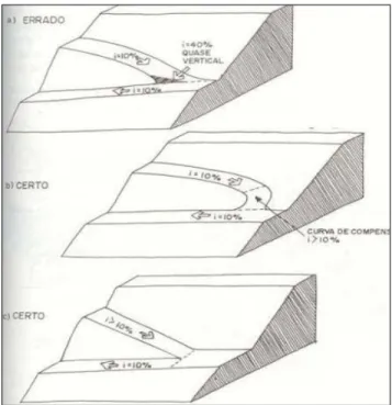
In the area of urban planning, the land surveying can help in various areas: demarcation of lots of houses, preparing the layout of streets, roads slope to facilitate car and pedestrian traffic. Mascaro (2003) sets from the declivity the best conditions for pedestrians in the public vias (Figure 6). The author also considers the various types of street layout for areas with steep slopes, promoting a plan of draining for the area. This contribution can be easily shared
in the field of Civil Engineering, in order to have an integrated planning between the type of construction and the town, which it is bound.
Figure 8 - Slope to the streets according to the pedestrian. Source: Mascaro (2003)
In the context of Agricultural Sciences is essential to the survey in order to facilitate planning for increased agricultural production. Simply put, it allows us to identify areas that may have greater access to water and thus, identification of areas with agricultural potential, facilitating decision-entrepreneur's to allocate its resources (Silva & Silva, 2016).
As a proposal for study of mathematics discipline, Santos et al., (2013) used surveying methods to teach students. Correlating principles of geometry with use of surveying instruments the students learned to calculate the volume and area of the campus. Pittela and Salbego (2014) exposes the importance of Surveying in the Civil Engineering, because it is able to provide values of distances and horizontal and vertical angles with accuracy. The authors
explain that the topography can characterize imperfections or flatness of the terrain that will enter the building, be it buildings, dams, roads, water and sewage networks, viaducts, tunnels or bridges, for example.
Jobs in the construction area and mechanical industry are demanding automatic procedures for measuring and monitoring more precisely. Moreover, new measurement systems have been studied and developed for the purpose of increased flexibility, quality and positional control (Seixas et al., 2007).
Coupled to this, the survey in certain civil buildings is related to all kinds of accidents leading to falls of people, equipment, cutting exposure to dust and harmful atmospheric conditions human health (Granemann, 2010).
Creating several conditions for the shooter, Oliveira et al. (2009) managed by topographic methods raise various bullet trajectories with a possible weapon. The authors emphasized that the positional expertise of a case of firearm shooting is important to know the location of the missile firing, thus facilitating the research process.
Gama et al. (2012) state that for urban cadastral survey in densely urbanized areas has the option to integrate GPS methods poligonação methods using total stations. This integration enables good results to transport the georeferenced coordinates of a base to the other, which transport along the stretch can serve as reference points for the definition of boundaries.
This same integration was observed for watershed identification in the south of the Rio Grande region of the South. Oliveira (2014) at first, it was an analysis of the location of the satellite images and topographic survey in the field was
possible to determine the sources of more clearly watercourses that were inserted in the watershed of the stream of Chuí. Knowing the watershed of a particular area is not only important to evaluate the springs, but the division of boundaries that often consider natural characteristics of a given region.
FINAL CONSIDERATIONS
Given this approach, it is noticeable the contribution of the Surveying in various spheres of the human activities. Technological development has allowed us to have a ground measurement more accurately with aid from GNSS receivers, aerial photogrammetry methods as well as the total stations.
Therefore, with the dissemination of scientific information of new topographic methods for further refinement and technological progress makes the topography a science constantly changing and although it is quite old, is still very current.
REFERENCES
BLAINEY, G. Uma breve história do mundo. São Paulo, SP: Editora Fundamental Educacional, p. 1-130. 2009.
BRANDALIZE, M. C. B. Topografia. Curitiba: PUC/PR, 2016, 59 p.
COELHO JUNIOR, J. M.; ROLIM NETO, F. C.; ANDRADE, J. S. O. Topografia Geral. Recife: Editora UFRPE, 199p, 2014
COLLIER, P. The Impact on Topographic Mapping of Developments in Land and Air Survey: 1900-1939. Journal Cartography and Geographic Information Science 29, 2002, p. 155-174.
DEMBSKEY, E. J. The aqueducts of ancient Rome. Dissertação de mestrado. University of South Africa.?, 2009. 99 p.
DIAS, L. S. O. Identificação de áreas suscetíveis a deslizamento de terra utilizando Sistema de Informações Geográficas. Dissertação de mestrado. Salvador: Universidade Federal da Bahia, 2006, 87 p.
DILKE, O. A. W. Roman Large-Scale Mapping in the Early Empire. In: The history pf Cartography. Chicago: University of Chicago, 1987, p. 212-233. DINIZ, M.A.V. Análise do relevo para otimização do uso e ocupação do terreno utilizando SIG. Monografia (Especialização). Belo Horizonte: Universidade Federal de Minas Gerais, 2002, 29 p. GAMA, L. F.; SEIXAS, A.; SOUZA, A.M.B. Implantação e análise de estruturas geodésica Planimétricas obtidas por GPS e estação total: Aplicações em levantamentos cadastrais urbanos. Revista Brasileira de Cartografia (2012) N0 64/2: 227-247.
GRANEMANN, D. C. Identificação e análise de riscos em levantamentos topográficos de barragens de usinas hidrelétricas: estudo de caso na UHE Salto Caxias. Bol. Ciênc. Geod. 16, no 4, p.609-622, out-dez, 2010.
GREINER, C. Avaliação do referencial de nível das inundações da cidade de Lajeado/RS com relação à régua linimétrica do Porto de Estrela/RS. Monografia. Lajeado: UNIVATES, 2014, 88 p.
IBGE (Instituto Brasileiro de Geografia e Estatística). Noções básicas de Cartografia. Rio de Janeiro: IBGE, 1998, 127 p.
LOC (Library of Congress). Geography and Maps.
Available in: <http:// www.loc.
gov/rr/geogmap/guide/gmillgen.html> . Access: May, 2016.
MARQUES, H. A. Introdução a Geodésia. Recife :UFPE, 2015. 129 p.
MASCARÓ, J. L. Manual de Loteamentos e
Urbanização. Available in: <
imobiliaria.mastergeoengenharia.com.br/imagens/e ditor/files/ManualMascaro.pdf> Access: May, 2016. OLIVEIRA, L. W. et tal. O uso da topografia para auxilio de Recuperação de uma área degradada. Fórum Ambiental da Alta Paulista 10, 2014, p. 326-341.
OLIVEIRA et al. Métodos de identificação do divisor de drenagens entre o arroio Chuí e o Arroio Pastoreio, Região Sul Do Rio Grande Do Sul. Revista Brasileira de Cartografia (2014) N0 66/5: 1067-1073. OLIVEIRA, A. A. A. et al. Determinação da trajetória espacial de um projétil em balística forense utilizando topografia. Revista Brasileira de Cartografia 61/04, 2009: 385-390.
PITELLA, M. S.; SALBERGO, A. G. Aplicação da topografia na Engenharia Civil. Anais do Salão Internacional de Ensino, Pesquisa e Extensão v.6, 2014, p.1.
PINHEIRO, R.P.C. Cartografia e Topografia Aplicada à Arqueologia. Available in: < http://wwwwebartigos.com/artigos/cartografia-e-topografia-aplicada-a-arqueologia/105 071/>. Access: May, 2016.
SANTOS, M. E.; OLIVEIRA, A. M. L.; ALVES S. C.
O. Levantamento topográfico: modelagem
matemática sobre áreas e volumes na agrimensura. Revista Eletrônica do Curso de Pedagogia do Campus Jataí –UFG 14, 2013, p. 1-16.
SILVA, D. C. Introdução aos métodos de levantamentos. Recife: Universidade Federal de Pernambuco, 2012, 61 p.
SILVA, J. R. M.; SILVA, L. L. Agricultura de precisão. Exemplo da avaliação do efeito da topografia e da rega sobre a variabilidade espacial e temporal da produtividade do milho. Available in < https://dspace.uevora.pt/rdpc/handle/10174/1926>. Access: May, 2016.
SEIXAS, A. et al. Uma abordagem geodésica de técnicas ópticas de medição tridimensional para determinaçãoe transporte de alturas em áreas de risco. Bol. Ciênc. Geodésicas 13, n 1, p.165-185, jan-jun, 2007.
TESTONI, A. J.; BACKES, F. A. A. L. A importância da topografia na recuperação de áreas degradadas. Revista Ágora 16, 2009, p. 52-62.
UFBA (Universidade Federal da Bahia). Evolução histórica e tecnológica do instrumental topográfico. Available in: <www.topografia.ufb a.br/evolu cao%20tecnolo gicatop. pdf> . Access: May, 2016.