2º CICLO EM SISTEMAS DE INFORMAÇÃO GEOGRÁFICA E ORDENAMENTO DO TERRITÓRIO
Current and future hospital locations in
Vanuatu: A GIS Contribution within
Vanuatu Health Policy
Charlington Leo
M
Charlington Leo
Current and future hospital locations in Vanuatu: A GIS
Contribution within Vanuatu Health Policy
Dissertation of Master in Geographical Information Systems and Spatial Planning Supervisor: José Augusto Alves Teixeira
Co-supervisor: Elsa Maria Teixeira Pacheco
Faculty of Arts, University of Porto
Current and future Hospital locations in Vanuatu: A GIS
contribution within the Vanuatu Health Policy
Charlington Leo
Supervisor: José Augusto Alves Teixeira Co-Supervisor: Elsa Maria Teixeira Pacheco
Jury Members
Professor Doctor Fatima Matos Professor Doctor Alberto Gomes Professor Doctor Jose Texeira
Contents
Acknowledgement ... 4 Resumo ... 5 Abstract ... 6 Index of Figures ... 7 Index of Tables ... 8 Index of Charts ... 9 Abbreviations ... 10 Chapter 1. Introduction ... 12 1.1 Context setting ... 12 1.2 Study area ... 13 1.3 Health status ... 16 1.4 Research Problem ... 171.5 Aims and Objectives ... 18
1.6 Thesis structure ... 18
Chapter 2. Literature Review ... 21
Chapter 3: Materials and Methods ... 25
Chapter 4: Results and Discussion ... 27
Chapter 5: Conclusion and Recommendation ... 44
Bibliography ... 45
Anex 1 ... 47
Acknowledgement
This research dissertation was completed with the help and support of important people. Initially, I am so grateful to God who showered with the blessing of knowledge and understanding through my time of study. A very special thank you to Professor José Augusto Alves Teixeira, My Supervisor for his unlimited support which motivated me to complete this thesis though he is also a busy lecturer at the University. Thank you also to my Co-supervisor Professor Elsa Maria Teixeira Pacheco for her support. To Professor Alberto Antonio Gomes, thank you for the support, encouragement and constant reminders keeping focussed on this Dissertation. Also to all other professors from the department of Geographic information system (GIS), thank you for your support during the thesis period.
Secondly, a special thank you to my Mother and my Family who without them I would not have come this far. Thank you for believing in me, giving moral support and for your love. I have been always proud to be part of such family and I believe you will be proud of this work.
Special thank you to Vanuatu National Statistics office (VNSO) for your support to me in all ways for this research and as my team at work. I am grateful to Benuel Lenge whose been a backbone for motivation, data issues to this completion and Ben Tokal for constant encouragement and support to upper institutions for this work. I cannot thank you all enough and I hope this output will make you smile. I’m so grateful to Vanuatu Ministry of Health (MoH) and Air Vanuatu for providing other data for this Research.
Finally, thanks to Orkhan for support, help and motivation staying up late doing the thesis here at FLUP. Also, to Luis, Inês, Victoria, Mafalda and Sesilia thank you for making study life and living in Porto awesome and a memorable one.
Resumo
O acesso aos serviços de saúde é um objetivo global, proporcionando à população recursos para se manter saudável e em forma. O Ministério da Saúde de Vanuatu tem o mesmo objetivo de fornecer serviços acessíveis, eficientes e acessíveis com as Infraestruturas de Saúde disponíveis como tal para Hospitais, que é o objetivo deste trabalho. Em primeiro lugar, as rotas de voo são analisadas para todas as províncias contra a localização dos Hospitais em todas as províncias de Vanuatu. A análise inclui mapas de todas as rotas domésticas semanais para Vanuatu, entre as respetivas províncias e os dois centros urbanos, Port Vila e Luganville. Foram também produzidos mapas que mostram as rotas semanais dentro de cada província.
Os mapas são então discutidos e interpretados tendo em conta a necessidade de acesso aos serviços de saúde e se as instalações de saúde estão localizadas em locais convenientes, e que se relacionam com outros serviços que as pessoas necessitam regularmente. Tendo analisado as tendências atuais dos vôos e a localização actual dos hospitais, este trabalho tentará fazer uma proposta de uma uma área adequada para o novo hospital no futuro, tendo como referência a Política de Saúde de Vanuatu, sobre os critérios para o estabelecimento de novas instalações que, para esta trabalho, são Hospitais . Os métodos de análise espacial serão utilizados para criar mapas dos melhores locais possíveis para construir novos hospitais.
Palavras-chave: infra-estrutura de saúde, acesso, rotas de vôo, política de saúde de Vanuatu, análise espacial
Abstract
Access to health services is a global aim, providing the population with resources to stay healthy and fit. Vanuatu Ministry of Health has that same goal of providing accessible, efficient and affordable services with the available Health Infrastructures as such for Hospitals which is the aim of this work. Firstly, the flight routes are analysed for all provinces against the location of Hospitals in all provinces of Vanuatu. The analysis includes maps of all weekly domestic routes for Vanuatu, between respective provinces and the two urban centres, Port Vila and Luganville. It also has maps that show the routes even within each province in a week.
The maps are then discussed and interpreted as to what the data say about access to health services and if the health facilities are located at convenient places that relate to other services that people regularly need. Having analysed the current trends of flights and the location of existing location, will further the thesis to find a suitable area for new hospital in the future with reference to the Vanuatu Health Policy on the criteria for establishment of New facilities which for this research is Hospitals. Spatial analysis methods will be used to create maps of best possible locations to build new hospitals. Keywords: Health infrastructure, Access, Flight routes, Vanuatu Health Policy, Spatial Analysis.
Index of Figures
Figure 1: Vanuatu Map by Provinces………17
Figure 2: Vanuatu Domestic weekly flights………..30
Figure 3: Flights between Luganville and Torba province………31
Figure 4: Flights between Luganville and Malampa……….32
Figure 5: Luganville and Penama flights………...33
Figure 6: Port Vila and Penama flights………...36
Figure 7: Port Vila and Malampa flights……….37
Figure 8: Port Vila and Tafea flights………38
Figure 9: Port Vila and Luganville flights………....39
Figure 10: Torba flights………...41
Figure 11: Penama flights………...42
Figure 12: Malampa flights……….43
Figure 13: Shefa flights……… 44
Index of Tables
Table 1: Access to clean water source and Improved sanitation
1995-2008……….13
Index of Charts
Abbreviations
AUY Anatom Airport (Aneityum Airport) AWD Aniwa Airport
CCV Craig Cove Airport DLY Dillon's Bay Airport EAE Siwo Airport
FTA Futuna Airport ZGU Gaua Airport IPA Ipota Airport
LPM Malekula Airport (Lamap Airport) LNB Lamen Bay Airport
LOD Longana Airport LNE Lonorore Airport
SON Santo-Pekoa International Airport MWF Maewo-Naone Airport
MTV Mota Lava Airport NUS Norsup Airport OLJ Olpoi Airport PBJ Paama Airport
VLI Bauerfield International Airport UIQ Quoin Hill Airport
RCL Redcliffe Airport SSR Sara Airport
SLH Vanua Lava Airport SWJ South West Bay Airport
TAH Whitegrass Airport (Tanna Airport) TGH Tongoa Airport
TOH Torres Airport ULB Ulei Airport VLS Valesdir Airport WLH Walaha Airport MoH Ministry of Health
VNSO Vanuatu National Statistics Office GIS Geographic Information System PICs Pacific Island Countries
NDH Northern District Hospital VCH Vila Central Hospital
Chapter 1. Introduction 1.1 Context setting
Accessibility to health services is a primal need for all humans globally. The need to stay healthy is only solved if people access easily the services they require at the time they are in need. Status of access to health services and infrastructures are different amongst different regions worldwide. Access is easy for high and medium level countries compared to least developed countries as to which are the focus of this thesis research. The medium that connects people and health services includes Roads, transportation (air/land and sea) and the financial means. Infrastructural services like roads, wharves and airports connects people to services like education, socio-economic activities like health as a primal service. To go to a health facility for emergency services or normal check-up for health needs, it is necessary to have access to main roads for vehicles to transport sick patients from remote areas to the nearest facilities. For areas in the suburb and rural areas, airports and wharves are necessary for transporting people to get treatment or diagnoses to get well.
The presence of the transport means through the infrastructures does not mean all groups of people access every time. Economical and financial cost of access to afford these services is paramount to determining how many manage to get services from the health facilities especially hospitals and health centres let alone the health service fee itself. All societies have they’re group of status; the rich, average and poor simpler if many would like to use; employed and unemployed.it is vital to consider this area to help locate accessible but affordable health facilities to serve their purposes as to providing services to surrounding population the area accommodates and account for.
1.2 Study area
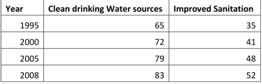
Located in the South west of Pacific Ocean is the Republic of Vanuatu, an archipelago of 83 islands divided into 6 provinces of volcanic origin situated west of the Fiji island and 123 kilometres east of Australia (Vanuatu National Statistics Office, 2015)(see figure 1). It is listed under least developed countries where services are not easily accessible to citizens though the population living near urban centres are more fortunate to access. Vanuatu have a population of 234,023 (Vanuatu National Statistics Office, 2015) with over 75percent living in the rural areas. The islands are remotely situated a chain position forming a letter Y. The proportion of population that have access to clean water sources and improved sanitation facilities is increasing (see table 1). In 2008, over 80 percent of population of Vanuatu access clean water and over 50 percent used improved sanitation facilities.
Year Clean drinking Water sources Improved Sanitation
1995 65 35
2000 72 41
2005 79 48
2008 83 52
Table 2: Proportion of Vanuatu population with access to clean water source and Improved sanitation 1995-2008(Indexmundi,2011)
The population of Vanuatu by sex has a close percentage though there are more males than females according to the 2009 census findings (See Chart 1).
Chart 1: Population of Vanuatu by sex (VNSO,2015)
The Ministry of Health (MoH) in Vanuatu over looks all the health status, services and all health-related issues/areas of Vanuatu.it was supported by the government and other donor partners for projects and implemented programs with the ministry and all-around Vanuatu for health support in one way or the other.
According to MoH website of Vanuatu, their vision is “to have an integrated and decentralized health system that promotes effective, efficient and equitable health services for the good health and general wellbeing for the people of Vanuatu.” (Administrator, 2015). The decentralization came into effect in 1994 when the Vanuatu government implemented the Decentralization policy act by creating 6 provinces (Figure 1 below) with each having their own provincial running under the Vanuatu government. The MOH in response provides hospital services in five provinces most of which occupy former mission hospitals who have been demoted down to health centres in the 1990’s a decade after Vanuatu gained its independence in 1980.
51% 49%
Population
Male Female
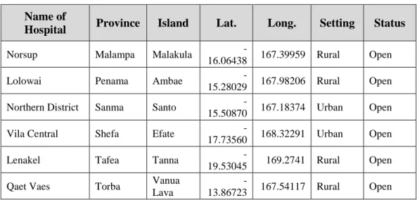
There are two reference hospitals in the two urban centres respectively: Vila central
hospital (VCH) in Port Vila, Efate island and Northern District hospital (NDH) in
Luganville, Santo island. The remaining four remaining provinces have: Torba Provincial
Health office in Torba, Lolowai hospital in Penama, Lamap hospital in Malampa and
Lenakel hospital in Tafea province (See Table 1 below).
Name of
Hospital Province Island Lat. Long. Setting Status
Norsup Malampa Malakula
-16.06438 167.39959 Rural Open
Lolowai Penama Ambae
-15.28029 167.98206 Rural Open Northern District Sanma Santo
-15.50870 167.18374 Urban Open
Vila Central Shefa Efate
-17.73560 168.32291 Urban Open
Lenakel Tafea Tanna
-19.53045 169.2741 Rural Open Qaet Vaes Torba Vanua
Lava
-13.86723 167.54117 Rural Open
1.3 Health status
In Vanuatu, the two major diseases that are affecting the people are communicable and non-communicable diseases. Malaria and Tuberculosis (TB) are the common diseases along with Sexually Transmitted Infections (STI), HIV and AIDS. Other diseases includes; Infant Mortality, Mortality and diagnosed diseases.
1.4 Research Problem
The issue is very pressing for my country, Vanuatu. There is need for more hospitals in my country as geographically the islands remotely apart from each other. Also, some of the current locations of hospitals are hard to be accessed by people in rural areas which make up about 75% of the Vanuatu Population. These new hospitals that are needed however, must be properly located that it is fair to access by the citizens should they want to serve their real purposes.
The research topic: "Current and future Hospital locations in Vanuatu: A GIS
contribution within Vanuatu Health Policy"
This research is based on using Geographical information system(GIS) techniques to
assess current hospital locations to see the relationship between surrounding areas and
their access to respective hospitals and health services available to them. Since Vanuatu
is geographically composed of little islands that are remotely scattered, it is quite a
challenge to plan the best locations for new hospitals. But thanks to spatial analysis
techniques of GIS it helps to determine the best possible locations of new hospitals which
is the aim of this research thesis. Using GIS to address health issues minimizes the effort
required to solve the issue. The application of the GIS techniques of spatial analysis tools
addressing the criteria’s’ needed will eventually produce result like possible site
1.5 Aims and Objectives
The main objectives of this research are:
• To analyze the locations of current hospital locations according to the Vanuatu Health policy implemented by the Ministry of Health in Vanuatu.
➢ Cartography analysis in forms of maps of domestic flights and the schedules in Vanuatu overall.
➢ Spatial analysis of the access of people to the main referral hospital in Vanuatu (VCH and NDH) by airline from respective provinces.
➢ Analysis of provincial flights in respective provinces with the location of provincial hospitals
• Determine best possible locations of hospitals in Vanuatu using the set criteria’s in the Vanuatu health policy
➢ Use spatial analysis to find suitable location of a new hospital in Shefa Province.
1.6 Thesis structure
develop this research, its main questions and the objectives. Chapter II introduces the
literature background which reviews each research themes that contextualize the
dissertation: it describes and explain how research and other case studies show the relation
relationships between Health systems and services relate to other variables therein. It also
focuses on which areas the previous articles or literature did not cover in the aspect of
this research and seeing the effectiveness of these sources to the completion of this
research thesis.
Chapter III is the methodology which outlines the data sources by type either primary or
secondary data sources and programs or applications use to do the analysis. It also
describes the steps taken to carry out the analysis and why they are used instead of other
relevant ways or techniques.
Chapter IV presents the analysis and discussion of the results obtained or derived from
the steps and techniques describe Methodology. These includes tables and maps produced
and created. The results are discussed and evaluated against the objectives of the research
thesis. It explains what the results mean and why those results are obtain and what the
results mean in the context of the health systems and hospitals established met the
criteria’s set out in the Health policy. Whether also if the new determined locations of new hospitals are easily accessible, efficient and will maximize the purpose of this
research.
Chapter V is the conclusion that summarize the key findings and evaluation to conclude
the research. It also has recommendations of some areas that future research should
authorities to consider when planning for future establishments of heal facilities as such
Chapter 2. Literature Review
2.1 Concept of Health system and Infrastructure
Due to the rise in demographic trends in the population and wealth, there will be more demand in infrastructure especially social and the likes. More capital should be dedicated to education and health to accommodate and keep the growing economies to be sustained. Infrastructure of roads also will connect people and households to the locations of education and health to ensure it serves its purpose to the surrounding population (PWC, 2014).
As part of sustainable development program, Disasters and climate change are affecting the health infrastructure. Low lying pacific islands are the first to suffer and the last to respond. Locations of hospitals in the low-lying areas are mostly of no planned, however, there are they because of political interests or proposed by some charitable or private companies (European Union - The Pacific Islands Forum Secretariat, Pacific Regional Indicative Programme for the period 201-2020, 2015). Their vulnerability to disasters and climate threats shows they lack factors that should have been consider beforehand like height above sea level, located with a dense population and accessible in short time so as close to main roads.
According to a brief from World Health Organization (WHO), the Pacific Island Countries(PICs) are characterized by not much population and are scattered among many remote islands with telecommunication and transport cost that are high yet with poor infrastructures (WHO, 2013). The need for better and efficiently location of hospitals to be built are the goal to cover the population to accessing the facilities and those that are standardized with recent health facilities. Population in areas in the pacific in particular Vanuatu for the case of this study has more than one-third (39%) of the population was younger than 15 years of age - youthful population, according to 2009 census (Vanuatu National Statistics Office, 2015),therefore, there is urgent need of new health facilities and hospitals as most of these youths have now reached child bearing age, especially the
respond to changing epidemiological situations and such demographic trends (Archer, 2014).
2.2 Relationship between Medical supply system and Millennium Development Goals (MDGs).
The millennium development goals that are health related are a stirring aspect of accessing the health system and services provided especially in the Pacific Island countries (PICs) as for this case study the context of Vanuatu. MDGs 4 Reduce Child Mortality; MDG 5 is Improve Maternal health; MDG 6 on Combating HIV/AIDS, Malaria, and other diseases; and MDG 8 developing global partnership for development (United Nations, 2010). The Vanuatu Ministry of Health (MoH) is responsible for the distribution of medical supplies to the health facilities throughout the entire country. These facilities fall into four different groups; Hospitals, Health centres, Dispensaries and Aid post and distributed along the hierarchy pattern starting from the Central Medical Store (CMS) in Port Vila and the Division Pharmacy. The five (5) hospitals in the country both the referrals and Provincial receives medical supplies from CMS and distributes to the three lower groups of health facilities within their respective zones as more commonly refer to as their provincial zones (Vanuatu MoH, 2004). On the other hand, complicated cases of patients are referred to the elite groups going to dispensaries to health centres or hospitals directly. Therefore, they inter-relate; the supply goes down the chain to lower groups while difficult cases are referred up the higher standard facilities.
The means of how medical supplies reach the facilities either routinely and the access rate of these supplies determine or measure the achievement of the MDGs. As referred to in the research ( Brown A, Gilbert B, 2012), one factor causing the lateness or regular routine of supply is the geographical locations of facilities as they are remotely scattered. The Chain of supply is hindered or untimely as transportation by land (vehicle), sea and Air is needed to complete the distribution of medical supplies. The measurement of the achievement of the MDGs depends if supplies are delivered and facilities (all groups)
respective facilities. Cost is a main factor slowing the distribution of medical supplies, thus, the lack of finance for provincial facilities the later the deliveries and the MDGs not met or achieved and consequences are severe.
The research on Medical supply system and MDGs is useful to this research as it allows the room for interventions to mend the relationship of health facilities, supply system and a better assessment avenue for MDGs. Unless the Health policy makers maintained the bonded relationship, they will operate as disable as they are and improvement of people’s lives, effectiveness and access of good health will never be achieved.
2.3 The use of Geographic Information System (GIS) for Health Infrastructure Planning Health planning and policy implementation has come a long way. Until the few recent years when GIS as a system has been used for managing, representing and analyse spatial data to facilitate and reduce costs in the process for selecting sites for establishment of health infrastructure (Mohammad, Ali, & Abbas, 2009). Increasing population nowadays amplifies the demand for new health facilities like hospitals. GIS is used to select optimal site for hospital construction using criteria’s temporal restrictions, social restrictions not forgetting economic constraints ( (Brabyn & Skelly, 2002).
According to (Brabyn & Skelly, 2002), Geographical access to New Zealand hospitals by the people are best explained and assess by GIS. GIS data layers are used to see the level or access in terms of time and distance travelled to nearby hospitals. Having figure that out they find better ways using constraints from these variables to plan effective or optimal sites to build new hospitals to ease access for the population. In the study conducted by (Mohammad, Ali, & Abbas, 2009),Another way they use GIS for health planning is the use of Accessibility Index that sees the ratio of Population density and the travel time to hospitals or health centres nearby. This implies that GIS is vital for effective planning in health especially the locations to establish new health facilities that is fair to all in terms of ease of access, same distance covered to reach the facilities.
2.4 Using GIS for Planning: Challenges
The use of GIS for planning is widely used around the globe and reduce costs and time to provide solutions relating to all the sectors particularly for health. Though the use of GIS is promising, there are challenges arising also when entire dependency on GIS.
challenge for the use of GIS for malaria research and control. This is due to lack of finance to fund the data collection and conversion paper maps as well as data to digital format to use for research and analysis of Malaria. The same applies for data for location of health facilities and other infrastructure that will aid the effective planning for new health facilities such as hospitals and health centres.
Another challenge of using GIS is lack of qualified human resources to work and use GIS. Since GIS uses new technology, there is need to train the current human resource the skills needed to work with and that goes with the cost to provide trains as well. In addition to knowledge about GIS, decision-makers do not understand its application. Therefore, the motivation to get financial support to do the work of GIS for health is not that effective. Lack of software to perfume spatial analysis and its tasks are not that well understood. Moreover, these software’s are controlled in powerful countries like Europe and United states (Niel & Pat, 2003). This affects how to get copies of the software’s or getting support for the software should problems are encountered.
Chapter 3: Materials and Methods
3.1 DATA SOURCES:
The data used for this work was:
➢ Census data.
Population Data has been obtained from the Vanuatu national statistics office (VNS0) from Vanuatu. The data received is the population by province and islands so as Area councils (Administrative zones). In addition, GIS shape files of Vanuatu are provided by VNSO to create maps of Vanuatu. The shapefiles include; Contours, Islands, Coastline, Airports, Health facilities, roads.
➢ Vanuatu airlines data
The national Airlines of Vanuatu (Air Vanuatu) provided data on the schedule of weekly domestic flights throughout Vanuatu. The data includes the number of flights and routes between the all respective islands that have airports established on them respectively through Vanuatu. The data provided has the list of All airports in Vanuatu by island and International Air Transportation Association (IATA) code.
➢ Vanuatu Ministry of Health
Data for health facilities are provided by the MoH of Vanuatu and has data on health services and infrastructure and the likes. The list of all health facilities by type; Hospitals, Health centres, Dispensary and Aid posts. It has data segregated by their location and their status (Active or Not). The data received also has the role delineation (criteria’s’) of the establishment of new health facilities in Vanuatu. Unfortunately, it only applies to Aid posts, Dispensaries and Health centres. Advice from the Health Sector Analyst from MoH was that anything higher further than the Health Centres can be used as criteria for Hospital establishment.
3.2 GIS programs and software:
ArcGIS 10.4 software is used to make analysis and maps that is in this research thesis. It is vital program that spatial analysis and cartography maps are generated from and as for this research, it is the suitable program for GIS that best give results that are intended to be produced.
3.3 Methods and steps for Analysis:
➢ Firstly, create data from excel to shapefiles (Airport data). All data are there but not in the formats that can be use in ArcGIS program to create maps to analyse access to hospital facilities by air planes. The data have to be manually created and then converted as shapefiles before they can be used for analysis.
➢ Secondly, Create Maps for flight analysis within Vanuatu. The maps created are from all levels the National, city to provinces and within respective provinces themselves and the islands therein.
➢ Thirdly, using Spatial analysis techniques, the province of Shefa be analysed to find a possible location for new hospital to be built in the future. Criterias to be used are outlined by the MoH of Vanuatu and some other main
Chapter 4: Results and Discussion
4.1 Health services and access: Vanuatu global view
The geography of Vanuatu is typical and uniquely comprised of remotely located islands that stretched in a Y shape chain of Volcanic islands which makes analysis quite a challenge. GIS however ease the challenge using several types of data like administrative data and national data that is made available from the government and other private institutions. Due to the lack of some data for analysing Health services at health facilities and access, these research tries to analyse how the people of Vanuatu access health services by using Airlines (Planes) that are beyond the capabilities of Health centres, Dispensaries and Aid posts in the rural communities in Vanuatu.
The trends of domestic flights in Vanuatu originates from the two main air ports at both Urban centres in Vanuatu; Port Vila/Bauerfield on Efate island and Santo/Pekoa airport on Santo island. The routes either started from one town and ends in the other after passing through the islands on different days and different times. According to figure 2, the flight routes and number of flights makes total sense in the context of people moving to certain points or places in huge numbers. Most either move to their provincial centre to access services and in the case of this research they travel to get medical help from hospitals. Access is only possible when the medium of transportation is available to move people between their homes to services centres (PWC, 2014). For Vanuatu generally, as depicted by in figure 2 that almost all major islands have airports that allows the people to travel from islands to their provincial hospitals to receive treatment.
Torba, Penama and Malampa province are in the northern and central of Vanuatu and have flights connected to Luganville, Santo. Some people travel to Santo first before connecting to Port Vila via the flights going to Vila from Santo if Luganville is not their destination. An explanation that could be drawn from the flight routes and numbers shows the direction from provincial hospitals to NDH for sickness that could not be taken care of. Similarly, is the case for flights from Malampa, Penama and Tafea flights that connects to Port Vila on Efate. VCH is the referral for untreatable cases and sickness in the
4.2 The movement of people between p rovinces and the two referral hospitals by plane: Northern District Hospital(NDH) and Vila Central Hospital (VCH).
Figure 3: Flights between Luganville and Torba Province (Weekly schedules: Air Vanuatu, 2016)
Luganville, Santo receives flights from Torba, Malampa and Penama province. The flights between Torba and Santo are from Gaua and Vanua Lava (see Figure 3). Information represented on the map shows that flights from Sola Airport (SLH) to Santo-Pekoa (SON) and SON to Gaua Airport (ZGU) are many in number compare to the other two flight routes presented on the map. The thicker the flight route the higher the number of Flights per week. Therefore, health wise, those flights are of which people or sick patients are transported to Luganville for complex diseases like surgery or the likes.
Figure 4 shows the flights from Luganville to Malampa and vice versa which shows significant number of flights in both direction of the flight routes. However, there are more flights between Luganville and Malampa than with Torba. This might be due to the fact that for Malampa, the only flights to Santo is from Malekula island alone, thus all islands in Malampa province going to Santo for medical services have to connect through or fly from Norsup airport (NUS). For people who are sick and going to Santo flying from Malekula is reasonable as they may have been sent from Norsup Hospital which is also in the same area as the airport.
The flights between Penama and Luganville shows that more flights in both direction are from Ambae compared to Pentecost and Maewo island (Figure 5). Lolowai hospital is located on Ambae approximately 5 kilometres from Longana (LOD).
Figure 6 presents the flight routes down the southern side of Vanuatu especially connecting the flights to and from Port Vila-Bauerfield Airport(VLI) to Penama province. In opposition to the flights between Penama and SON, most flights are between Pentecost and VLI compare to Ambae and Maewo. As for analysis of people seeking further treatment from VCH, most are flown directly from Pentecost island while the rest from LOD whereby they might have been referred to VCH by Lolowai hospital. Also reading from the map in Figure 6, more flights both ways is higher for Lonorore (LNE) compared to the other two air ports.
has direct flights from all airports to Port Vila-Bauerfield airport regardless of the number of flights as shown in the flight route thickness. Thus, it is easier and efficient way to transport emergency patients or regular sick people to get medical services in VCH in Port Vila.
Port Vila and Tafea flights has much more flights per week compared to all other provinces of Vanuatu. VLI and Lenakel Airport (TAH) has around 10 flights respectively each direction of the route (Figure 8). Erromango also some direct flights to Port Vila but low in number of flights. Tafea provincial hospital (Lenakel) also is in the same area as the airport (TAH). All the surrounding islands of Tafea province travel to Lenakel to access services provided by the hospitals. However, if situation gets out of hand that is when they refer them to VCH which from the analysis shown by the map would evidently meant they travel from TAH to VLI for emergencies or referral.
the flights between the two urban areas; the Capital Port Vila and the second town Luganville is as high as the number of flights between VLI and TAH in Tafea. In both towns, the location of hospitals is closed to the airports (Figure 9). Though both are regarded as referral VCH seems to be the higher standard and NDH sometimes send patients to VCH for the final decision on treatment. People travel through the two areas in search for their own plans or work yet it could be refer as also travelling to sought anything health related even if it’s just regular check-up.
4.3 Flights within respective provinces to access services from their pro vincial hospitals.
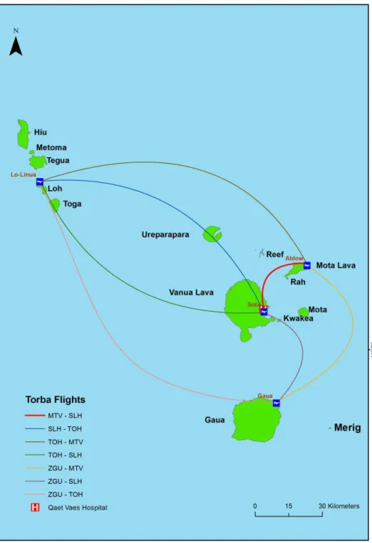
Accessing health services at a provincial level within each province was governed by the provincial government of all provinces. They are responsible for the regular supply of medical supply and maintenance of their hospitals. Figure 10 shows the flight routes with Torba province in a week and clearly how most flights come in and out of Sola (SLH) which is the provincial Headquarter and where Qaet Vaes hospital is located.
The flights that intercepted through come from both with Banks islands and the Torres group which ideally depict that sick patients travel to Vanua Lava island to sought medical help. Figure 11 similar shows the same pattern of movement through main headquarter except this time in Penama province. All flights have the connection at LOD which is also exactly on Ambae and close to Lolowai hospital.
In addition, the flight routes within Malampa (Figure 12), Shefa (Figure 13) and Tafea Province (Figure 14) shows the same pattern of flight routes and concentrations. All the infrastructure of health and Air transportation are closely located and make access to each of the services and facilities very easy and efficient. Therefore, as a criterion for the finding suitable location, the access and closeness of areas with such infrastructure it can be said that it has met the criteria.
Chapter 5: Conclusion and Recommendation
5.1 Conclusion
Upon completion of this research, the objectives are quite achieved. The analysis of the current hospital locations all follow the pattern of locating near airports which makes it accessible to people and not isolated from other services that people needed daily. The schedules and flight routes per week varies from provinces and more flights are between Santo and Port Vila so as Port Vila and Tanna island.
The need of finding a best suitable area for a new hospital is a challenge especially in Shefa province as not all data needed are available but should they had been, it would ease the burden. Population is increasing and so is the need for new hospitals to be built to cater for the additional to current population.
5.2 Recommendations
To improve this research in the future here are some areas to improve:
➢ Make sure all administrative data are available. The government or private institutions should invest in creating data or databases to capture information of transportation by Boats with each island and the purpose of service. Also, Transport and buses on land that transport people to get medical help from health facilities.
➢ The government through the MoH to create new role delineation that provides the requirements of building new Health facilities.
Bibliography
Brown A, Gilbert B. (2012, 07 23). The Vanuatu Medical supply system - documenting opportunities and challenges to meet the Millennium Development Goals. Southern Med Review, 14 - 21. Retrieved from Southern Med Review.
Administrator. (2015). Vanuatu Ministry of Health. Retrieved from Vanuatu Government Ministries: www.moh.vu/
Air Vanuatu. (2016, November). Weekly schedules. Port Vila, Shefa Province, Vanuatu.
Archer, L. (2014, 02 12). Using Geographic information Systems(GIS) Mapping for Better Health Planning-Binduri District. Retrieved 07 13, 2016, from Advanceing Research on
Comprehensive Health Systems: http://arches.columbia.edu/using-geographic-information-system-gis-mapping-for-better-health-planning-binduri-district/ Brabyn , L., & Skelly, C. (2002). Geographical Access to Services, Health (GASH): Modelling
Population Access to New Zealand Public Hospitals. International Journal of Health Geographics.
European Union - The Pacific Islands Forum Secretariat, Pacific Regional Indicative Programme for the period 201-2020. (2015, 07 02). Retrieved 07 14, 2016, from eeas.europa.eu: https://eeas.europa.eu/pacific/documents/eu-pifs-signed-2014-2020_en.pdf FLETCHER-LARTEY1, S. M., & CAPRARELLI, G. (2016). Application of GIS technology in public
health: successes and challenges. Parasitology, 401- 4 15. Indexmundi. (2011). Vanuatu. Retrieved from Index Mundi:
http://www.indexmundi.com/vanuatu/#Health
MoH. (2004). Vanuatu Health Policy . Port Vila: Ministry of Health (MoH).
Mohammad, H. V., Ali, A. A., & Abbas, A. (2009). Hospital site seelection ussing fuzzy AHP and its derivatives. Journal of Environmental Management, 3048-3056.
Niel, G. S., & Pat, D. (2003). Challenges in using geographic information systems (GIS) to understand and control malaria in Indonesia. Malaria Journal, 1- 8. Retrieved 06 14, 2017
PWC. (2014, 10). Infrastructure Development in Asia Pacific (APEC) The next 10 years. Retrieved 07 14, 2016, from www.pwc.com: https://www.pwc.com/gx/en/capital-projects-infrastructure/assets/infrastructure-development-in-asia-pacific.pdf
United Nations, (. (2010). The Millennium Development Goals Report United Nations. Retrieved from un.org:
http://www.un.org/millenniumgoals/pdf/MDG%20Report%202010%20En%20r15%20-low%20res%2020100615%20-.pdf
Vanuatu MoH. (2004). Ministry of Health - Master Health Services Plan 2004-2009. Retrieved from Wpro.who.int:
http://www.wpro.who.int/countries/vut/VanuatuHealthMasterPlan_LIGHTVERSION.p df
Vanuatu National Statistics Office. (2015). Retrieved 07 13, 2016, from VNSO: http://www.vnso.gov.vu/index.php/census-and-surveys/censuses
Anex 1
Name of
Facility Designation Province Island
Health
Zone Lat. Long. Ownership Setting Status
Norsup Hospital Malampa Malakula MAL01
-16.06438 167.39959 MOH Rural Open
Lolowai Hospital Penama Ambae PEN01
-15.28029 167.98206 MOH Rural Open Northern District Hospital Sanma Santo SAN01
-15.50870 167.18374 MOH Urban Open
Vila Central Hospital Shefa Efate SHE01
-17.73560 168.32291 MOH Urban Open
Lenakel Hospital Tafea Tanna TAF01
-19.53045 169.2741 MOH Rural Open Qaet Vaes Hospital Torba Vanua
Lava TOR03
-13.86723 167.54117 MOH Rural Open Hospital facilities and information (MoH,2016)
Anex 2