LIGHTNING AND PRECIPITATION PRODUCED BY SEVERE WEATHER SYSTEMS OVER
BELÉM, BRAZIL
WANDA MARIA DO NASCIMENTO RIBEIRO
1, JOSÉ RICARDO SANTOS SOUZA
2, MÁRCIO
NIRLANDO GOMES LOPES
3, RENATA KELEN CARDOSO CÂMARA
1, EDSON JOSÉ PAULINO
ROCHA
1, ARTHUR C. ALMEIDA
4 1Universidade Federal do Pará (UFPA), Departamento de Meteorologia, Belém, Pará, Brazil.
2UFPA, Departamento de Geociências, Belém, Pará, Brazil.
3Centro Gestor e Operacional do Sistema de Proteção da Amazônia (CENSIPAM), Centro Regional de
Belém, Belém, Pará, Brazil.
4
UFPA, Departamento de Matemática, Belém, Pará, Brazil.
[email protected], [email protected], [email protected], renatakelenc@gmail.
com, [email protected], [email protected]
Received August 2013 - Accepted November 2014
ABSTRACT
CG Lightning flashes events monitored by a LDN of the Amazon Protection System, which included
12 LPATS IV VAISALA sensors distributed over eastern Amazonia, were analyzed during four severe rainstorm occurrences in Belem-PA-Brazil, in the 2006-2007 period. These selected case studies referred to rainfall events, which produced more than 25 mm/hour, or more than 40 mm/ 2 hours of precipitation rate totals, registered by a tipping bucket automatic high-resolution rain gauge, located at 1° 47’ 53’’ S and 48° 30’ 16” W. Centered at this location, a 30 ,10 and 5 km radius circles were drawn by means of a geographic information system, and the data from lightning occurrences within this larger area, were set apart for analysis. During these severe storms the CG lightning events, occurred
almost randomly over the surrounding defined circle, previously covered by mesoscale convective
systems, for all cases studied. This work also showed that the interaction between large-scale and
mesoscale weather conditions have a major influence on the intensity of the storms studied cases. In
addition to the enhancement of the lightning and precipitation rates, the electric activity within the larger circles can precede the rainfall at central point of the areas
Keywords: Lightning, Storms, Amazonia.
RESUMO: RELÂMPAGO E PRECIPITAÇÃO PRODUZIDOS POR SISTEMAS DE TEMPO SEVERO EM BELÉM, BRASIL
Eventos de raios nuvem-solo registrados pela rede de detecção do SIPAM, integrada por 12 sensores VAISALA LPATS IV, distribuídos no leste da Amazônia, foram analisados durante 4 tempestades com ocorrência de precipitação intensa em Belém-PA-Brasil, em 2006-2007. Esses casos selecionados, correspondem a eventos de chuva com mais de 25 mm/hora ou 40 mm/ 2 horas, de precipitação registrada por um pluviômetro instalado em 1° 47’ 53’’ and 48° 30’ 16” O. Com centro nessa localização, um
círculos de 30, 10 e 5 km de raio foram traçados através de um sistema de informação geográfica e os
dados de eventos de raios nessas áreas foram separados para analise. Durante essas tempestades, os eventos de raios ocorreram de maneira quase aleatória, sobre a área maior que já havia sido previamente coberta por sistemas convectivos de mesoescala, em todos os casos. Esse trabalho também mostrou
a grande influencia dos sistemas de larga escala nas condições de tempo que levaram às tempestades
severas estudadas. Adicionalmente, foi observado que, quando existe interação entre sistemas de larga
e meso escalas, tanto a precipitação como o numero de relâmpagos aumentaram significativamente e
1. INTRODUCTION
Severe weather has been a permanent concern to people, considering its potential to cause loss of lives, damage to property, and regarding other environmental concerns, all over the world (Ortega et al., 2009; Kohn, et al., 2011; Qie et al., 2009; Dimitrova et al., 2009;Pucik et al., 2011). Intense rainfall and lightning storm occurrences are associated to strong convection and meteorological systems in large and mesoscales, which enhance them following the daily solar heating pulses (Feng et al.,2009; Mastrangelo et al., 2011; Sátori et al., 2009; Matsudo and Salio, 2011; Mattos and Machado, 2011; Curic et al., 2009).
The events of rainfall and lightning storms naturally depend on the local climate, land and ocean surface characteristics. Their forecasts are of critical importance when they occur over populated or urban regions as is the case of Belém, whose metropolitan area has over 2.5 million inhabitants.
In Brazil several studies have been made on this topic (Farias et al., 2009; Rodriguez et al., 2010; Machado et al., 2009; Almeida et al.,2011; Davidson et al., 2012; Silva Dias, 2007). In the especial case of the Brazilian Amazon Region these studies are scarce, and the present work is supposed to contribute to the understanding of the peculiarities of the regional weather, when intense storms occur. It deals with four severe storms
occurrences with the objective to find out the climatic context
and the characteristics of the meteorological systems which produced them, as well as, the time and space relationships between precipitation and lightning.
The severe weather storms in Belém should be studied taking into account the regional climatic characteristics. For
instance, El Niño events in the Pacific Ocean appear to decrease
the total rainfall in the eastern Amazon, while during La Niña periods one observes positive anomalies of precipitation (Cutrim et al., 2000). These authors determined a high correlation between
the anomalies of sea surface temperatures (SST) of the Pacific and
Tropical Atlantic oceans, with the duration of the rainy season in this Region. The occurrence of a positive SST anomaly in the
Equatorial Pacific favors a short rainy season in the Amazon.
However, when a positive anomaly occurs in the Tropical South Atlantic, a long rainy season is observed in the same region.
The convection in the Amazon region is an important mechanism for heating of the tropical atmosphere and its variations, in terms of intensity and position, play a key role in determining the weather and climate of this region. Waliser and Gautier (1993) showed the importance of the Intertropical
Convergence Zone (ITCZ) in the definition and analysis of the
terrestrial climate on a global scale. Molion (1993) studied the macro and mesoscale circulations that act in the Amazon and the dynamic processes that organize and promote the precipitation in
that area. The dynamic mechanisms that produce precipitation in the Amazon were also described by Vianello and Alves (1991). According to these authors they result from the combination of the predominant role played by the ITCZ, the squall lines, the penetration of frontal systems, the source of water vapor represented by the Amazon forest and the role of the Andes. On the other hand, the occurrence of mesoscale systems such as squall lines, may be responsible for up to 45% of the precipitation in the eastern Amazon Region (Cohen et al., 1989).
In addition to the above mentioned meteorological
phenomena, the Amazonian climate variability is significantly influenced by the intra-seasonal large scale phenomenon called
the South Atlantic Convergence Zone (SACZ) (Kodama, 1992; Quadro, 1994; Nogues-Paegle and Mo, 1997; Liebmann et al., 1999). This extensive cloudiness band produces large increments of precipitation over southeastern Brazil and central and western Amazonia, during the summer months of the southern hemisphere. Frequently, parts of this system drift northward, resulting in increased rainfall over eastern Amazonia. It is common during these episodes the occurrence of a coupling of the SACZ with the ITCZ, in association with systems such as the Bolivian High and cyclonic vortices at high levels, which can cause widespread rainfall and lightning storms over much of eastern Amazonia (Gan and Kousky, 1986; Souza and Ambrizzi, 2003).
The squall lines (SL) formed on the Atlantic coast of the Amazon are responsible for a large part of the rain formation near the coast, as well as, in central Amazonia. These lines are characterized by having large clusters of cumulonimbus clouds and are formed along the coast due to the sea breeze circulation. The development of a cumulonimbus cloud is associated with the presence of warm, moist and unstable air, and usually produce local storms with high incidence of lightning, strong winds, sudden temperature changes, and occasionally tornados (Vianello and Alves, 1991). In addition to these characteristics, Gandú (2004) suggested that the proximity to the ocean and large
rivers, creates areas with specific spatial and temporal variability
of precipitation. The mesoscale circulation associated with the sea breeze is an example of very active structured convective systems whose squall lines propagation over the continent, is
responsible for a significant portion of the precipitation in this region (Cohen et al., 1995)
1999), showing that high CAPE value is a necessary but not
sufficient condition for the formation of deep convection and electrified cumulonimbus clouds which may produce lightning. In the Amazon, lightning was first studied based on
thunder data recorded by meteorological observers at weather surface stations (Serra, 1997; Nechet, 1994). These studies showed that this region has one of the highest keraunic indices in the world, usually greater than 140 thunder days per year. This was expected due the frequent formation of cumulonimbus clouds over the region, which has high rainfall (above 2500 mm/year) in its east and west sub-regions (Souza and Ambrizzi, 2003).
Recent studies made with precipitation estimates and lightning detections made through sensors on board of the Tropical Rainfall Monitoring Mission (TRMM) satellite, by Teixeira et al. (2008; 2009) and Ribeiro et al. (2009a,b) have shown that higher lightning production is associated frequently to mesoscale meteorological systems with cloud tops ice crystals, over eastern Amazonia. These systems also produce intense rainfall in all sub areas of this region.
Another study by Almeida et al. (2007) conducted an analysis of the characteristics of lightning and rainfall during
five storms observed in Belém. In this more localized study,
the maxima lightning occurrence rates observed, preceded the maxima rainfall rates measured at the center of the lightning detection area, by at least 20 minutes. Additionally, Ribeiro et al. (2008) examned the relationship between lightning and rainfall
in the wettest months (February and March) and one dry bimester (July and August) of the year 2007, in Belém. Their results also showed that the frequency of lightning strikes per hour reached their maxima always preceding the corresponding maximum precipitation over this area. In general, it was observed that the rainfall peak delay after the lightning occurrence rate peak was about 45 minutes on the average. This seems to indicate that the lightning occurrence rate may be used to warn about imminent heavy rain, in this area (Ribeiro et al., 2008). The possibility to use this parameter as a short term predictor to severe storms, in the near future, provided stimulus for the detailed analysis of four severe storms events observed simultaneously by the Amazonian Protection System – Lightning Detection Network (SIPAM – LDN), digital pluviometers and satellite images, presented in this work. All these new storms selected produced both intense rainfall and a large number of lightning events around the metropolitan area, surrounding Belem. The cloud-to-ground occurrence rate within the time frame of the rainfall observations were made by local institutions, through a joint effort which will be described further on, in this work.
2. MATERIALS AND METHODS
2.1 Area of study - location and characteristics
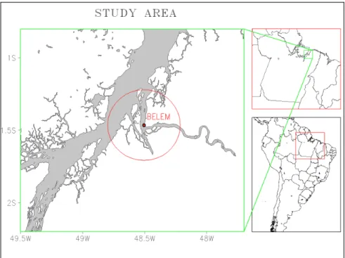
The study area (Figure 1) was defined within a circle
of 30 km radius, covering the metropolitan area of Belém,
plus close water surfaces. It was centered at the Brazilian 4th Naval District Headquarters weather station, with geographical coordinates 1º 47’ 53” S and 48º 30’ 16’’ W, where is installed the main high time resolution rainfall gauge, used for data collection.
Belem is located at the confluence of the Guamá River
with the Guajará Bay, about 150 km away from the Atlantic Ocean, along the southern shore of the mouth of the Amazon
River. The level of its surrounding water masses is significantly
determined by tides, which during the trimester March to May, may exceed the 2.5 m amplitude. This period coincides with part of the local rainy season, when the precipitation is strongly
influenced by the inter-annual variability of the atmospheric
general circulation, accumulating most of its nearly 3,000 mm annual average total (Figueroa and Nobre, 1990). The rainy period in Belem is largely modulated by the drift of the Inter Tropical Convergence Zone (ITCZ) over this equatorial latitude (Ferreira, 1996), frequently producing severe lightning and rain storms, from January to May. The combined simultaneous
effect of the high tides with severe rainfall, is the overflow of the drainage channels of the city, resulting in serious traffic jams and economic losses to its population. At present, no real time flood
warning system is available to mitigate these situations, through the local Civil Defense and communications media. This work represents an attempt to contribute to the development of a low cost intense rainfall warning method, based on the knowledge of the relationship between the lightning frequency of occurrences and the associated rainfall, during severe storm events, in Belém.
The main socio-economic impacts associated with rain
storms and lightning are related to the overflow of channels and rivers, flooding of roads and houses. For the analysis of
socioeconomic impacts were selected events of severe storms with material losses as reported through the local news media,
such as roads and homes flooded in several neighborhoods, and slow traffic on the main access route to the city. In especial, the four
stormy days selected for study caused consequences and impacts according to the local news media, as we can be seen in Table 1.
The newspaper “Diario do Para” published on December 12, 2007 printed the headline “Storm: City is again facing chaos”.
This newspaper edition described the impossibility of traffic on some streets, traffic accidents and also the situation whereby three cars that were swept away by the flash flooding waters.
On January 10, 2007 the newspaper “Diário do Pará” and “O Liberal” brought headlines about the heavy rain occurrence on the day before. They displayed the headlines: “Thunderstorms are back and causing disorders” and “Flooding worsens quality of life”, respectively.
The floods caused by the rainfall on February 14, 2007,
caused much inconvenience to the population in the affected areas as described in an article published in the issue of February15, 2007 of the newspaper “O Liberal” where the headline read:
“One hour of rain overflows the city”. It took about an hour of rain to flood the periphery and the center of Belém. There was flooding in 6 neighborhoods. The water invaded houses, shops and offices. The traffic was jammed for several hours.”
On March 3, 2007 the newspapers reported several traffic jams and traffic accidents occurred due to heavy rain that fell on the city in about 30 minutes on the previous day. The fire
department also registered 10 instances of landslides an fallen tree and several car accidents.
2.2 Lightning data
The individual lightning flash occurrences data used in
this study were collected by the Amazon Protection System
Day Rainfall
(mm) Summary of published news Impacts
Dec. 11, 2006 65.2 "Intense Storm Made City to Face Chaos Again"
Flash floods, traffic jams and car accidents, etc.
Jan. 09, 2007 35.0 "Flooding Worsens Quality of Life"
Floods, traffic jams and car accidents, etc.
Feb. 14, 2007 59.4 "One Hour of Rain Floods the City"
Houses and shops flooded in six neighborhoods.
Mar. 02, 2007 53.4 "Rain Floods Almirante and Duque Avenues
Floods, traffic jams and car accidents, landslides and fallen tree, etc.
lightning detection network (SIPAM-LDN), which included 12 sensors LPATS IV, manufactured by Vaisala. These data were registered in the international format ASCii Lightning Universal Format (UALF) on a stable platform UNIX® , computing solutions from LF signals. Their times of arrival are inputted as raw data from various sensors of the system. Detection solutions were processed by a software at a central station (CP 8000) of the network, installed in Belem. The lightning locations are sent directly to display devices in real time, including an analysis
of the network performance; and/or stored on files for several
applications.
The Microsoft Office EXCEL 2007 was used to process
the charts displaying the behavior of lightning versus rainfall during the periods of the storms.
Figure 2 shows the layout of the LPATS-IV sensors, located over four Brazilian states in the eastern Amazon Region. Six sensor sites are in the Para (PA) state, four in the Maranhão (MA) state, one in Mato Grosso (MT) state and one single sensor in the Tocantins state. Except for two sensors located further east (São Luís and Barra do Corda, both in Maranhão), the SIPAM- LDN spatial distribution shows a nearly axial
configuration with northward extremes in Breves and Belém,
and the southern extremes located in São Félix do Araguaia, in Mato Grosso, and Natividade, in Tocantins.
This LDN received maintenance at the end of 2006, so that in 2007 it was operating with one of its best detection
efficiency levels. Its performance was degrading during subsequent years and it is presently out of operation.
2.3 Precipitation data
The analysis of the severe storms days was made using data from a high time resolution pluviometer, operated by the Mineral Resources Research Company (CPRM) in Belem.
Belém has an extensive drainage network formed by rivers and channels, many of the latter with paved embankments and silted beds. In addition to these conditions,
the influence of the tide, which can block the natural flow
of some of these rivers and canals, is an extra factor that
can cause overflow of the natural drainage network. Thus,
high rates of precipitation, especially when they occur simultaneously with the high tide, greatly increase the risk
of urban flooding. According to Santos (2010), rainfall rates exceeding 12 mm / h represent imminent risk of flooding to
some urban watersheds of Belém.
These case studies referred to rainfall events, which produced more than 25 mm/hour or more than 40 mm/two hours, of precipitation totals, registered by a tipping bucket automatic pluviometer located at 1° 47’ 53’’ S and 48° 30’ 16” W. This
pluviometer time resolution was five minutes or 0.2 mm rainfall accumulation, whichever occurred first. To draw the figures, the
rainfall data were totaled at 15 minutes intervals.
2.4 Analysis of the atmospheric data
The synoptic conditions, i.e., the weather systems that
influenced the storm events were characterized using data
available at the National Center for Environmental Prediction - NCEP, with the following variables: outgoing longwave radiation (LWR), low and high wind levels, air temperature and relative humidity. The daily LWR data were derived from polar-orbiting weather satellites (Liebmann and Smith, 1996), covering the period from 1974 to the present. This variable is arranged in a regular global grid with a resolution of 2.5º latitude by 2.5º longitude, having been used to characterize the convective activity associated with tropical weather phenomena, whereas the threshold for deep convection was considered to be around 240 Wm-2, as described in Zhang (1993) and Lau et al. (1997).
Daily averages of the zonal and meridian components of wind, air temperature and relative humidity were obtained from the NCEP reanalysis. These data are generated through a consistent data assimilation system used in its global circulation model (GCM) with a resolution of the NCEP T62L28 (approximately 210 km in latitude versus longitude and 28 vertical levels), according to Kalnay et al. (1996). The analysis of horizontal wind allowed the evaluation of active synoptic systems. The wind data, together with the air temperature and relative humidity were used to calculate the moisture convergence for the area of study.
3. RESULTS AND DISCUSSION
3.1 Lightning characteristics from four selected events of severe storms
Table 2 presents data from four storm events that occurred in Belém. From the displayed physical characteristics
of the observed flashes, it is evident that the day of strongest
electrical activity was 11 December 2006, with 699 lightning
flashes and 65.2 mm of rain. The day with fewer lightning
events among the selected four, occurred on March 02, 2007
with only 31 events lightning. It is also observed that all events studied were detected at least by four sensors.
3.2 Case 1: severe strom occurence on december 11, 2006 3.2.1 Meteorological analysis
Figure 3 shows the sequence of images captured through the infrared channel of the GOES- 12 satellite at 2045 UTC,
Table 2 –Lightning and rainfall data from four severe storms observed around Belém.
Figure 3 - GOES-12 satellite infrared channel image on December 11, 2006 at 20:45 UTC showing the presence of deep convective systems near the region of Belém.
which allows us to identify the formation of a convective cluster between the region of Belém and the Marajó Island in the evening of December 11, 2006.
The low values of LWR indicate deep convection (Lau et al., 1997) associated with vertically well developed cloudiness, which favors the formation of cumulonimbus clouds and thunderstorms. In Figure 4b one may see a band of convective clouds predominantly oriented NW / SE, featuring the South Atlantic Convergence Zone (SACZ), organized from over the state of Amazonas towards southeastern Brazil. This storm, represented as CASE 1, resulted from the projection of a branch of the SACZ over the area of interest.
The interaction between phenomena of different scales, in this case the SACZ and the sea breeze along the northeastern Pará Atlantic coast, resulted in the convergence of moisture and wind direction observed on Figure 4c, acted simultaneously for the formation of a squall line that caused this severe storm in Belém, during December 11, 2006, together with a large number of lightning and high rainfall volume (Figure 4a).
3.2.2 Local weather conditions.
According to weather reports regularly released by operational staff stationed at the Belém International Airport (SBBE), known as METAR code (Meteorological Aerodrome Report), there were four important moments during this storm, as described below in Table 3.
At 1600 UTC on December 11, 2006, the predominant wind was from northeast, with an intensity of 6 knots. The air temperature increased, reaching 31 ºC. At that moment, there were already some cumulus towers and a large high cloud layer, probably of cirrostratus, characterizing the approaching of the top of a cumulonimbus.
Immediately after 1700 UTC, light rain occurred, thus contributing to a reduction of 3 °C on the near surface air temperature. The proximity of a cumulonimbus system caused variations on the wind direction, which changed towards the southeast.
The first thunderstorm at the station (SBBE) was recorded at 2019 UTC. At that time the intense rainfall reduced the horizontal visibility to about 500 meters. Near 2200 UTC, the thunder registers ceased at the station (SBBE), but the rainfall remained light and continuous, as usually happens during the dissipation stage of a cumulonimbus
3.2.3 Space and time distributions of lightning and rainfall on December 11, 2006.
The Figure 5a shows the time distribution of the number
of lightning CG flashes and precipitation, which occurred on
December 11, 2006 in Belem. It appears that most of the electrical activity considering the events within the larger circle area occurred at 1900 UTC, with 101 events in 15 minutes. It was also noted that in the interval of 1900 to 2100 UTC, 636 CG events were detected, i.e., an average of 70 events every 15 minutes.
Figure 4 - (a) Outgoing longwave radiation -OLWR (W.m-2) ; (b) Moisture convergence and winds at 1000 hPa (m s-1) , Winds at 850 hPa (m s-1) and (c) Precipitation on Dec,11/2006.
Analyzing the temporal behavior of lightning with respect to total rainfall, one could verify that there were several rainfall events throughout the day. The hourly totals went up to 14.6 mm between 1700 and 2000 UTC, but their daily maximum was reached at 2100 UTC with 41.8 mm of rain. Considering the time at which the lightning rate peaks, one observes that as the lightning incidence area is drawn to smaller radius of 10 and 5 km, the lightning rate delay with respect to the time of the rainfall peak , tends to vanish.
The space distribution of the hourly lightning flashes on
December 11, 2006 (Figure 5b), shows two bands of lightning occurrences over the northwest and northeast of the area around 1900 UTC. Later on, the events seem to converge towards the urban area of Belém, placed at the center of the area of study.
3.3 Case 2: severe storm occurence on January 09, 2007 3.3.1 Meteorological analysis
The Figure 6 exhibits the highlighted infrared channel image from GOES-12 satellite on January 09, 2007, at 1800 UTC. It shows the presence of deep convective systems near the Belém area, with clouds whose temperature at their tops reached -70 ºC. This condition led to the development of cumulonimbus clouds with intense electrical activity. One may notice also a coupling of the ITCZ with the HLCV on the Brazilian Northeast favoring the occurrence of heavy rainfall over the states of Maranhão, Amazonas and Pará, due to the strong divergence at high levels of the atmosphere.
The active weather systems in the region on this day were: the ITCZ, with shaft around 2 ° C, entered between the states of Maranhão and Piauí , and coastal instability lines
from the State of Ceará to Pará. The low level circulation had winds blowing from the ocean to the continent, bringing more moisture (Figure 7a), while in the upper troposphere, prevailing winds circled the continent to the ocean (Figure 7b). The change of the wind vector at high levels of the atmosphere provided the wind shear, which contributed to the formation of intense storms and high volumes of rainfall, especially in the region of Belém (Figure 7c).
3.3.2 Local weather conditions.
According to METAR weather reports regularly released with observations made at the surface meteorological station of the Belém International Airport (SBBE), there were three important phases of the storm, as described below in Table 4.
There were strong indications, before noon, of high atmospheric instability on January 09, 2007. This day was characterized by high air temperatures, whose maximum
reached 34 °C at 1500 UTC ( 12:00 Local Time), when the first
cumulus towers appeared. At this time the predominant winds from northeast were weak, but they began to intensify, so that their speed reached 14 knots when the cumulonimbus clouds approached this station. Around 1700 UTC a light rain started, accompanied by thunder, restricting the visibility to 4 km in the eastern sector. Shortly thereafter, at 1710 UTC there was
intensification of precipitation, with heavy rain, thunder, and
the horizontal visibility was reduced to 1 km. At about 1740 UTC, the rainfall diminished its intensity to moderate and light;
and finally stopped at 1900 UTC. There was again formation of
cumulonimbus clouds at night which produced lightning but no rain, around the weather station.
Figure 5 - (a) Time relationship between lightning and rainfall. (b) - Space distributions of the hourly lightning occurrences around Belém, on December 11, 2006.
3.3.3 Space and time distributions of lightning and rainfall on January 09, 2007.
Figure 8b shows the time distribution of lightning during January 09, 2007. It can be observed that the electrical activity
peak within the 30 km circle, occurred at 1700 UTC, probably caused by large convective activity associated to the Bolivian High circulation and to episodes of a Cyclonic Vortex on the Brazilian Northeast which produced cloudiness on its edge, plus rain and lightning on the northeast of the State of Pará. The electrical activity on that day began at 1600 UTC, and the Figure 8b shows that it drifted from east to west.
The hourly distribution of the number of lightning, presented its largest incidence activity at 1700 UTC, with 34
flashes, while precipitation had its highest rainfall rate occurring
at 1730 UTC with 20.6 mm/15 minutes. The rainfall rate per 15 minutes dropped to 11.4 mm at 1745 UTC, and almost vanished at 1830 UTC.
In this particular case, Figure 8a indicates that the lightning peak rate of occurrences preceded the rainfall rate peak, for about 30 minutes within the 30 km circle, 15 minutes for the 10 km circle and no time gap was observed between these parameters for the inner 5 km circle. This
confirms the radial dependence of the time delay between
the lightning and rainfall peal rates, already observed in the previous case study.
3.4 Case 3: severe storm occurence on February 14, 2007
3.4.1 Meteorological analysis
The Figure 9 shows an image of the GOES-12 infrared channel, where is evident the presence of cloud systems as part of the large scale South Atlantic Convergence Zone (SACZ) and the Intertropical Convergence Zone (ITCZ) which were moderately active on the center and northern ares of the state of Para on February 14, 2007, at 1730 UTC. The interaction between these two systems contributed to a large electrical activity resulting in 134 lightning events in Belém and a total of 59.4 mm of rainfall.
Figure 10a shows the atmospheric circulation at low levels over northern Brazil and rainfall on February 14, 2007.
It displays the confluence of winds and mass convergence
at low levels, associated with the ITCZ, especially in the region of the Tropical Atlantic. These movements favor the transport of moisture and increased convection over northern South America, with evidence of the interaction between the Intertropical Convergence Zone (ITCZ) associated with sea breezes, thus favoring the formation of Squall Lines (SL). The favorable position of cyclonic vortices at high levels contributed to the heavy rainfall and large electrical activity in some localities in the northeast and eastern Pará, justifying the total of 59.4 mm rainfall registered in Belém on February 14, 2007.
Figure 7 - (a) Outgoing longwave radiation -OLWR (W.m-2) and (b) Moisture convergence and winds at 1000 hPa (m s-1) , (c) Winds at 850 hPa (m s-1) and Precipitation; on January 09, 2007.
Table 4–Sequency of METAR code registers from the airport station in Belém on January 09, 2007. Source: http://www.redemet.aer.mil.br
Figure 10b shows both, the Longwave Radiation (LWR) and winds at high levels of the atmosphere (200 hPa) indicating the presence of a frontal system on the northern part of the state of Bahia fed by moisture from the Amazon that contributed to the total rainfall above average in the states of Tocantins and most of Pará. The contribution of the Intertropical Convergence Zone (ITCZ) associated with the formation of Squall Lines (SL) and the favorable position of the high levels cyclonic vortices resulted on severe rainfall in some localities in the northeast and east of the state of Pará. It should be mentioned also that, the center of the Bolivian High was observed at the approximate position of 20 ºS, 72 ºW, near its climatological normal position. The interaction of all these systems must be taken into consideration in future forecasts analysis of severe weather conditions for the studied area.
3.4.2 Local weather conditions
According to the time observations made at the international airport of Belém, on February14, 2007, the day dawned partly cloudy turning to cloudy, still early in the morning. This situation contributed to the maximum temperature below 31 °C (Table 5). Beginning at 1500 UTC, towers of cumulus, and cumulonimbus appeared and evolved during the whole afternoon. The incoming winds were predominantly from the northeast direction and had weak intensity. A thunderstorm with moderate rain was recorded at 1800 UTC, with visibility restricted to 1km in the east sector and 4 km in the other sectors. The rain persisted throughout the night, but the storm ceased at 1920 UTC.
3.4.3 Space and time distributions of lightning and rainfall on February 14, 2007.
Figure 11a presents the temporal distribution of the lightning during February 14, 2007. It can be observed that the greater electrical activity occurred at 1700 UTC, coming from east to west, probably caused by the interaction of various systems that were active on the east and south of Pará.
The rainfall data from the 4th ND station were analyzed on that day revealing that the rainfall rate in Belém reached 41 mm in 30 minutes, with maximum rainfall occurring at 1830 UTC, with 21 mm in 15 minutes. It was also observed that the occurrence peak of lightning preceded the maximum precipitation rate by about 45 minutes within the 30 km circle, and about 30 minutes for both 10 and 5 km circles, in this case.
3.5 Case 4: severe storm occurence on March 02, 2007 3.5.1 Meteorological analysis
The Figure 12 exhibits the infrared channel image from the GOES-12 satellite at 1745 UTC, on March 2, 2007. The display of the cloudiness associated with the Intertropical Convergence Zone (ITCZ) shows that its band lays almost on the equator, with strong mass convergence there, favoring rainfall over northern Brazil. One may observe the interaction of the ITCZ with the HLCV over northeastern Brazil and a frontal system in the South of Brazil, activating the cloudiness in northeastern Pará. This combination of factors, produced heavy rainfall in the city of Belém, Pará, where 53.4 mm of rainfall were registered on that day.
Figure 9 - Image from the GOES-12 satellite infrared channel on February 14, 2007 at 17:30 UTC showing the presence of deep convective systems near the region of Belém, where one may observed clouds whose temperature reached -50 °C at their tops.
The wind field at low levels, was predominantly from the
south below the equator, and from the east above the equator. This
is consistent with the presence of the ITCZ and its influence on
the region, as shown by the strong moisture convergence (Figure 13a). The low values of longwave radiation, especially near Belém
where they reached less than 200 W / m² (Figure 13b) reinforce the prevailing conditions of strong atmospheric instability. The scenario in large and mesoscale had been completely favorable to the formation of deep convective clouds that originated storms with large rainfall accumulation levels, as shown in Figure 13c.
3.5.2 Local weather conditions.
On March 2, 2007 the skies were cloudy since early afternoon and the air temperature was around 33 °C. From 1700 UTC on, a moderate intensity rain began, restricting the horizontal visibility to 2 km in the northeast sector, from where the storm approached Belém. Cumulus clouds towers appeared in the early afternoon and evolved into cumulonimbus, producing thunderstorms after 1740 UTC, with moderate rain . This situation restricted visibility even more, to about 1500 meters. After 2100 UTC the rain reduced its intensity, keeping an intermittent character until 2100 UTC, when the lightning ceased. Strangely, at that time still there were no well-developed convective clouds of the cumulus tower type. Nevertheless, at 1800 UTC a localized system cloud produced strong gusts of wind and 46.4 mm of rainfall register in 15 minutes (Table 6).
3.5.3. Space and time distributions of lightning and rainfall on March 02, 2007
Figure 14b shows the time distributions of the CG lightning occurrences and rainfall during March 2, 2007. One can observe that the increased electrical activity occurred at 1700 UTC, probably caused by the interaction of several systems that were active on the east and southern areas of Pará. These systems can be better visualized in the satellite image (Figure 12). Still regarding this time distribution it was observed that the lightning occurrence rate peaked at 1730 UTC within the 30 km circle, that is, about 30 minutes before the maximum precipitation which occurred at 1800 UTC (Figure 14a). Such time gap was just a few minutes when the 10 km circle was
considered and no lightning flashes were detected within the
inner 5 km circle around that time.
4. CONCLUSIONS
Four severe weather storm occurrences near the city of Belém, PA, Brazil were analyzed, with respect to the lightning and rainfall, produced by them. Different space and time
evolutions of the storms were identified in association with especial configurations of the main climatic and meteorological
systems which produce intense convection over the selected study area of metropolitan Belém and its surroundings. Some
specific meteorological features such as the SACZ, the ITCZ, Figure 10 - (a) Outgoing longwave radiation –OLWR- (W.m-2)
and (b) Moisture convergence and winds at 1000 hPa (m s-1) , (c) Winds at 850 hPa (m s-1) and Precipitation during February 14, 2007.
Table 5 – Sequency of METAR code registers from the airport station in Belém on February 14, 2007. Source: http://www.redemet.aer.mil.br
the Bolivian High, the Northeastern Brazilian Trough, and breeze circulations, may be useful as prognosticators of intense convection and lightning plus rainfall severe storms in the area, many hours in advance of these occurrences. One of the
findings of this study was that even though most severe weather
in Belém come from thunderclouds drifting from northeast propped by the prevailing winds, lightning and the associated events appear to occur in a more or less random way in space, meaning that, when lightning starts to occur, the storm clouds are already covering almost all the 30 km circular area. Under these circumstances and in the now casting time scale, this work determined for all cases studied that the lightning occurrence rate tends to peak before the observed maximum precipitation occurs at the center of the lightning monitored area. However, this time delay depends someway on the radii of the circles around the reference pluviometer placed at their center. For the central area of 5 km radius in the cases studied this time gap tends to vanish. Therefore, a compromise radial distance of lightning monitoring should be established, if one desires to use lightning occurrence data to warn about imminent severe rainfall at a given point location, in this area of study.
Finally we wish to conclude that a combination of satellite and surface real time meteorological variables monitoring systems may provide useful information about severe weather storms in this area, and this research may contribute for future forecasts, seeking to mitigate the described storm losses to the local population.
5. ACKNOWLEDGEMENTS
The authors thank the Federal University of Para for the infrastructure made available to them. They acknowledge the use of data provided by The Amazonian Protection System
Figure 12 - Image from the infrared channel of the GOES-12 satellite on March 02, 2007 at 17:45 UTC, showing the presence of deep convective systems near the region of Belém, where it can be observed clouds whose temperature reached -80 °C at their tops.
Source: CPTEC/INPE
Figure 13 - (a) Outgoing longwave radiation – OLWR - (W.m-2) and (b) Moisture convergence and winds at 1000 hPa (m s-1) , (c) Winds at 850 hPa (m s-1) and Precipitation; during March 02, 2007.
Table 6 - Sequency of METAR code registers from the airport station in Belém on March 02, 2007. Source: http://www.redemet.aer.mil.br
Agency, The Brazilian National Institute of Meteorology, The Mineral Resources Research Company and the National Center for Environmental Prediction. The authors also thank The Brazilian Research and Projects Financier for the research grant provided to the Amazonian Monitoring Network Project - REMAM II, FINEP- and the fellowships from Coordination for the Improvement of Graduate Teaching Personnel (CAPES) and Brazilian National Research and Innovation Council (CNPq).
6. REFERENCES
ALMEIDA, A. C. A. C.; ROCHA, B. R. P.; MONTEIRO, J. H. A.; SOUZA, J. R. S.. Cloud-to-Ground Lightning Observations Over The Eastern Amazon Region, Atmospheric Research, v. 117, p. 86-90, 2012. doi: 10.1016/j .ATMORES. 2011.08.015.
ALMEIDA, A. C. ; ROCHA, B. R. P. ; MONTEIRO, J. H. A.; SOUZA, J. R. S.; VIEIRA, G. R.; SOUZA, E. B.; CUNHA, H. T. S.; SOUZA, W. A. P. 2007: Lightning Characteristics Associated to Severe Rainfall Events, Around Belém PA Brazil. In: IX International Symposium on Lightning Protection, 2007, Foz do Iguaçú. Anais... IX International Symposium on Lightning Protection. São Paulo : Institute of Electrotechnics and Energy of the University of São Paulo, 2007. v. 1. p. 57-60.
COHEN, J.C.P.; SILVA DIAS, M. A.F; NOBRE,C. A. Aspecto climatológico das linhas de instabilidade na Amazônia. Climanalise, Boletim de Monitoramento e Análise Climática. São José dos Campos, São Paulo, Brasil, INPE/ CPTEC, v. 4, n. 12, p.34-40, Dez. 1989
COHEN, J.C.P.; SILVA DIAS, M.A.F.; NOBRE, C.A. Environmental Conditions associated with Amazonian Squall Lines: a case study. Monthly Weather Review, v. 123, n. 11, p. 3163 – 3174, 1995.
CUTRIM, E.M., MOLION, L.C.B ., NECHET, D.: Chuvas na Amazônia durante o século XX, Anais... XI CBMET, Rio de Janeiro (RJ), SBMET, 2000.
´CURIC´, M., JANC, D., VUE`KOVIC´, V. The influence
of merging and individual storm splitting on mesoscale convective system formation. Atmospheric Research, v. 93, pp. 21-29, 2009.
DAVIDSON, E.A., ALESSANDRO, C.A., ARTAXO, P., JENNIFER, K.B., BROWN, I.F.,BUSTAMANTE,M.M.C., C O E , , M . T. , D E F R I E S , R . S . , K E L L E R , M . , LONGO,M.,MUNGER,W., SCHROEDER,W., SOARES FILHO, B.S., SOUZA JR.,C.M., WOFSY,S.C.,2012: The Amazon basin in transition. Nature, v. 481, p. 321–328, 2012 doi:10.1038/nature10717.
DIÁRIO DO PARÁ “Temporal faz cidade enfrentar o caos novamente”. Caderno Cidades. JornalO Liberal:
Belém-PA, 12 de dezembro de 2006 ,texto : Edna Nunes e Marcela Andrade.
DIMITROVA, T., MITZEVA,R., SAVTCHENKO,A. Environmental conditions responsible for the type of precipitation in summer convective storms over Bulgaria. Atmospheric Research, v. 93,pp. 30-38, 2009.
FARIAS, W. R. G.; PINTO JR., O.; NACCARATO, K. P.; PINTO, I. R. C. A. Anomalous lightning activity over the Metropolitan Region of São Paulo due to urban effects. Atmospheric Research, v. 91, pp. 485-490, 2009.
FENG, G.; QIE, X.; WANG, J.; GONG, D. Lightning and Doppler radar observations of a squall line system. Atmospheric Research, v, 91, pp.466-478, 2009.
FERREIRA, N.S. A Zona de Convergência Intertropical. In: NOBRE, Carlos Afonso.Climanálise Especial 10 Anos. São José dos Campos, 1996.
FIGUEROA, S.N.; NOBRE, C.A. Precipitation distribution over central and western tropical South America. Climanálise, v. 5, p. 36-45, 1990.
GAN, M. A.; KOUSKY, V. E. Vórtices ciclônicos da alta troposfera no oceano Atlântico Sul. Revista Brasileira de Meteorologia, v.1, p.19-28, 1986.
GANDÚ, A. W.; COHEN, J. C. P.; SOUZA, J. R. S. Simulation of Deflorestation in Eastern Amazonia Using a High-Resolution Model. Theoretical and Applied Climatology, v. 78, p. 123-135, 2004, DOI 10.1007/s00704-004-0048-5. GROENEMEIJER,P., CORSMEIER,U., KOTTMEIER,CH.
The development of tornadic storms on the cold side of a front favoured by local enhancement of moisture and CAPE. Atmospheric Research, v 100, p. 765-781, 2011.
KALNAY, E. et al. The NCEP/NCAR 40-year reanalysis project. Bulletin of the American Meteorological Society, v.77, n.3, p. 437-471, 1996.
KODAMA, Y. Large scale common features of subtropical precipitation zones (the Baiufrontal zone, the SPCZ, and the SACZ). Journal of the Meteorological Society of Japan, v.70, n.4, p.813-836, 1992.
KOHN, M., GALANTI, E., PRICE, C., LAGOUVARDOS, K., KOTRONI, V. Nowcasting thunderstorms in the Mediterranean region using lightning data. Atmospheric Research, v. 100, p. 489-502, 2011.
LAU K.M., WU , H.T.; BONY, S. The Role of Large-Scale Atmospheric Circulation in the Relationship b e t w e e n Tr o p i c a l C o n v e c t i o n a n d S e a S u r f a c e Temperature Journal of Climate, v. 10, p. 381–392, 1997. doi: 10.1175/1520-0442(1997)010<0381:TROLSA> 2.0.CO;2
convergence zone. Journal of Climate, v.12, p.1877-1891, 1999.
LIEBMANN, B.; SMITH, C. A. Description of a complete (interpolated) outgoing Long Wave Radiation dataset. Bulletin of the American Meteorological Society, v.77, p.1275-1277, 1996.
MACHADO,L.A.T., LIMA,W.F.A., PINTO JR.,O., MORALES, C.A. Relationship between cloud-to-ground discharge and penetrative clouds: A multi-channel satellite application. Atmospheric Research, v.93, p.304-309, 2009.
MASTRANGELO,D., HORVATH,K.,RICCIO,A.,MIGLIETT A,M.M. Mechanisms for convection development in a long-lasting heavy precipitation event over southeastern Italy. Atmospheric Research, v. 100, p.586-602, 2011.
MATSUDO, C. M., SALIO, P. V. severe weather reports and proximity to deep convection over Northern Argentina. Atmospheric Research, v. 100, p.523-537, 2011.
MATTOS, E. V., MACHADO, L. A. T. Cloud-to-ground lightning and Mesoscale Convective Systems. Atmospheric Research V. 99, p. 377-399, 2011.
MOLION, L. C. B. Amazonian rainfall and its variability. In: Hydrology and Water Management in the Humid Tropics, Ed., Cambridge University Press, p. 99-111, ,1993. MOTA, M.A.S.,NOBRE, C.A. Relação da variabilidade da
Energia Potencial Convectiva Disponível (CAPE) com a Precipitação e a Alta da Bolívia durante a campanha “Wet-AMC/LBA. Revista Brasileira de Meteorologia, v.21, n.3b, 344-355, 2006.
NECHET, D. Dias de Trovoadas na Amazônia. Anais do VIII Congresso Brasileiro de Meteorologia e II Congresso Latino-Americano e Ibérico de Meteorologia, Belo Horizonte – MG, v. 1, p. 184- 187, 1994.
NOGUÉS-PAEGLE, J.; MO, K. C. Alternating wet and dry conditions over South America during summer. Monthly Weather Review, v. 125, p. 279-291, 1997.
O LIBERAL. “Casas e bares alagados em Outeiro”. Caderno Cidades. Jornal O Liberal: Belém-PA, 12 de dezembro de 2006.
O LIBERAL. “Alagamento piora qualidade de vida”. Caderno Cidades. Jornal O Liberal:Belém-PA, 10 de janeiro de 2007. texto : Edir Gaya,
O LIBERAL _. “Chuva de uma hora alaga a cidade”. Caderno Cidades. Jornal O Liberal:Belém-PA, 15 de fevereiro de 2007.
O LIBERAL. “Chuva alaga a Almirante e a Duque”. Caderno Cidades. Jornal O Liberal:Belém-PA, 03 de março de 2007. ORTEGA, E.G., LÓPEZ,L., SÁNCHEZ, J.L. Diagnosis and
sensitivy study of twosevere storm events in the southeastern Andes. Atmospheric Research, v. 93, p. 161-178, 2009. PAWAR, S. D.; LAL. D. M; MURUGAVEL, P.. Lightning
characteristics over central Indian summer monsoon; Atmospheric Research, v. 106, p. 46-49, 2012.
PÚCIK, T., FRANCOVÁ,M., RÝVA, D., KOLÁR,M., RONGE,L. Forecasting challenges during the severe weather outbreak in Central Europe on 25 june 2008. Atmospheric Research, v. 100, p. 680-704, 2011.
QIE,X., et al. Electrical characteristics of thunderstorms in different plateau regions of China. Atmospheric Research, v. 91, p. 244-249,2009.
QUADRO, M. F. L., 1994: Estudo de episódios de Zona de Convergência do Atlântico Sul (ZCAS) sobre a América do Sul. 1994, 123f. Dissertação (Mestrado em Meteorologia) – Instituto Nacional de Pesquisas Espaciais, INPE, São Paulo.
RIBEIRO, W. M. N ; SOUZA, J. R. S. ; MOTA,G.V. ; TEIXEIRA, V. A. ; ALBUQUERQUE, J.C. ; SOUSA, J. R. A. Rainfall And Lightning Relations Derived From Trmm Satellite Data, Over Eastern Amazonia. In: X International Symposium on Lightning Protection, 2009a, Curitiba-PR / Brasil. Proceedings of the X International Symposium on Lightning Protection, 2009a.
R I B E I R O , W. . M . N . , S O U Z A , J . R . S . , S I LVA . , ALMEIDA,R,M,B, SOUSA,J.R.A., MONTEIRO,J.H. A,
ROCHA B. R. P., Cunha,H,T,S. Análise das Distribuições
Horárias de Raios e Chuvas em Belém-PA.XV CBMET-Congresso Brasileiro de Meteorologia São Paulo – SP, 2008.
RIBEIRO, W.M.N., SOUZA, J. R. S., TEIXEIRA, V. A., MOTA,G.V., SANTOS, A.P.P., SOUZA, E.B., LESSA,L.A.S. Local Relationships Between Lightning Frequency Of Occurrences And Precipitation In The Amazon Region. In: X International Symposium on Lightning Protection, 2009b, Curitiba-PR/Brazil. Proceedings of the X International Symposium on Lightning Protection.
RODRIGUEZ, C.A.M., ROCHA, R.P., BOMBARDI, R. On the development of Summer thunderstorms in the city of São Paulo: Mean meteorological characteristics and pollution effect. Atmospheric Research, v. 96, p.477-488, 2010. SANTOS, F. A. A. Alagamento e Inundação Urbana:
Modelo Experimental de Avaliação de Risco. 2010. 129f. Dissertação (mestrado em ciências ambientais) - Universidade Federal do Pará, Museu Paraense Emilio Goeldi, Embrapa, Centro de Geociências, Pós-Graduação em Ciências Ambientais, Belém, 2010.
SÁTORI, G.;WILLIAMS,E.,LEMPERGER,I. Variability of global lightning activity on the ENSO time scale. Atmospheric Research, v. 9, n. 1, p. 500-507, 2009. SERRA, A. Trovoada e névoa seca. Boletim Geográfico, Rio
SILVA DIAS, M.A.F. Furacões e Tornados um espetáculo de
rotação na atmosfera terrestre. Revista USP, São Paulo, n°.72 , p.44-53, dez./fev 2006-2007.
SOUZA, E.B. AMBRIZZI, T. Pentad precipitation climatology over Brasil and associated atmosferic mechanisms. Climanálise – Boletim de Monitoramento e Análise Climática, 2003:.
TAVARES, J. P. N. Enchentes repentinas na cidade de
Belém-PA : condições climáticas associadas e impactos sociais
no ano de 19871. Caminhos de Geografia, v. 9, n. 28 , p. 1 – 6, 2008.
TEIXEIRA, V. A. ; MOTA,G.V. ; RIBEIRO, J. B. M. ; SOUZA, J. R. S. Estudo dasCaracterísticas e Ocorrências de Sistemas Precipitantes na Amazônia. In: XV Congresso Brasileiro de Meteorologia, 2008, São Paulo.
TEIXEIRA, V. A. ; MOTA,G.V. ; SOUZA, J. R. S. ; GOMES, N. V. ; RIBEIRO, W M N ; SOUZA, E.B. ; SILVA, A. N. B. Relãmpagos e Chuva Volumétrica do satélite TRMM em
Nove Sub-regiões da Amazônia Oriental.. In: I Workshop de Previsão Climática Regional do Estado do Pará, 2009, Belém-PA. I Workshop de Previsão Climática Regional do Estado do Pará.
VIANELLO, R. L.; ALVES,A. R. Meteorologia básica e aplicações. Viçosa: UFV –Imprensa Universitária. pp. 337, 1991.
WALISER, D. E.; GAUTIR, N. E. Graham, and C. Gautier,
Comparison of the highly reflective cloud and outgoing
longwave data sets for use in estimating tropical deep convection, Journal of Climate, v. 6, p. 331-353., 1993. YAO, M-S and DEL GENIO, A.D.,1999: Effects of Cloud
Parameterization on the Simulation of Climate Changes in the GISS GCM. Journal of Climate, v. 12, p. 761–779. doi: 10.1175/1520-0442(1999)012<0761:EOCPOT> 2.0.CO;2
ZAWADZKI, I.; RO, C.U. Correlations between maximum rate of precipitation and mesoscale parameters. Journal Applied of Meteorology, v. 17, p. 1327-1334,1978.
ZHANG C. Large-scale variability of atmospheric deep convection in relation to sea surface temperature in the tropics. Journal of Climate, v. 6, p. 1898-1913, 1993. ZHANG ,C. AND CHOU, M-D., 1999: Variability of Water
Vapor, Infrared Radiative Cooling, and Atmospheric Instability for Deep Convection in the Equatorial Western