Water resources and the historic wells of Barbuda: tradition, heritage and hope for a sustainable future
Rebecca Boger
Brooklyn College, USA rboger@brooklyn.cuny.edu
Sophia Perdikaris Brooklyn College, USA
sperdikaris@brooklyn.cuny.edu
Amy E. Potter
Armstrong State University, USA amy.potter@armstrong.edu
John Mussington
Sir McChesney George Secondary School, Antigua and Barbuda john.mussington@gmail.com
Reginald Murphy
Ministry of Education, Sports, Gender and Youth Affairs, Antigua and Barbuda remurphy@hotmail.com
Louise Thomas
Barbuda Research Complex, Antigua and Barbuda
Calvin Gore
Barbuda Research Complex, Antigua and Barbuda
Dwight Finch
Barbuda Research Complex, Antigua and Barbuda
ABSTRACT: The island of Barbuda has a relatively unique history, land tenure and geography. Unlike its Caribbean counterparts, the island is not suited to large-scale agriculture due to its arid climate and relatively thin soils. Instead, the enslaved and eventually free people of Barbuda developed a complex herding ecology centered on common land ownership. As a result, carefully designed historic wells are strategically located around the island. With the challenges brought about by climate change, an interdisciplinary, international team led by the Barbuda Research Complex is investigating the state of existing water and food resources and examining how the availability and quality of water resources have influenced local cultural practices. Barbudans and international scientists are working together to improve their resilience and live more sustainably in this new era of climatic adversity.
Keywords: Barbuda, food, gardens, island, resilience, sustainability, water, wells
Introduction
The availability and quality of water is central to understanding human dynamics, particularly on a small island with limited rainfall throughout the year. For a thriving and healthy population, the raising of food (both plant and livestock), human drinking, and other forms of consumption, require an adequate and clean water supply. With climate change, low-lying small island states and territories face several severe and potentially imminent threats, including increased temperature and altered precipitation patterns, changing frequency and intensity of weather systems (especially hurricanes and tropical storms), ocean acidification, and sea level rise that can result in coastal erosion and saltwater intrusion of groundwater (IPCC, 2007; 2013). The lessening or mitigation of climate change impacts requires environmental monitoring of the status and trends affecting natural and cultural resources, so that efficient and pertinent adaptive strategies can be developed in collaboration with local inhabitants to establish meaningful and relevant lifestyles and practices for adoption.
The research presented here is a product of an interdisciplinary team of researchers led by the Barbuda Research Complex – Barbuda’s first and only research facility with registered ‘not for profit’ status under Antigua and Barbuda’s company legislation – in collaboration with local experts, the Human Ecodynamics Research Center at the Graduate Center, City University of New York, USA, and associated researchers from the international community and Brooklyn College, also in New York. Local and international experts have been conducting investigations highlighting long-term human eco-dynamics on this low-lying semi-arid island (Bain et al., 2010; Faucher, Guay, and Bain, 2011; Hambrecht, & Look, 2009; Hambrecht, & Feeley, 2010; Hambrecht, Hicks, Djuknic, et al., 2011; Perdikaris, 2009, 2010, 2011; Perdikaris, Grouard, Hambrecht, et al., 2013). There is a lengthy history of human habitation on the island, dating back to circa 4500 years BCE with Archaic peoples, followed by the Saladoid peoples (circa 200 BCE–1200 BCE), then people from Europe and Africa (17th to the 19th centuries), to the present day Barbudans. These investigations are revealing a complex interplay between culture and environment that has persisted in one form or another for several thousands of years (Perdikaris et al., 2013).
Barbudans have had an extensive history of adaptation and resilience on an island where daily life at times can be very unforgiving. The interplay between people and environment has been at the core of the human existence on the island. Through paleo-environmental work and study of archaeological sites, we have been able to see the response of plant and animal communities to droughts, increased rainfall and hurricanes (Burn, Bain, Kennedy, et al., 2011). We have also looked at shifts in settlement and examined the locations that humans have taken shelter in or established as campsites (Perdikaris et al., 2013). Barbuda was settled even when it was thought that peoples from the south would only desire larger islands. It continues to be an atypical modern-day island in the Caribbean in that it has special legislation so that the land is owned in common by all its people, and it might be one of the last Caribbean islands that practises hunting and gathering and living from the land.
and examine what is the state of those resources today. People and environment are never static; but long-term perspectives can assist to help establish models and strategies to assist in the future.
Barbuda physiography
Barbuda is a relatively flat coral island with a land area of 161 km2. It is located midway along the island chain known as the Lesser Antilles and is at the outer curve of the Leeward Islands, about 50 km northeast of its sister island, Antigua (Figure 1).
Figure 1: Physical map of Barbuda, along with its location in the Caribbean (inset).
According to the 2011 census, Barbuda has a resident population of 1,638 people. Codrington Village, where most of the islanders live, and the adjacent Codrington Lagoon, are to the west of the island. Codrington Lagoon is a dominant feature in Barbuda that spans about 10 km in length and 2 km in width and is separated by a narrow spit of sand that can be breached during tropical storms and hurricanes. The highest elevations toward the east are in the Highlands area. Here, hills rise to about 40 m.
Since Barbuda is low-lying, within the hurricane belt, and semi-arid with an annual precipitation of 750-900 mm (30-35 inches), the island may experience large impacts from climate change. In particular, the IPCC (2007) scenario projections indicate that temperatures will increase between 0.4 to 2.1°C by the 2060s and between 0.9 to 3.5 degrees by the 2090s, annual and seasonal rainfall will decrease, and sea level will increase globally at a rate of 1.7 mm/yr, although satellite observations since the early 1990s indicate a greater rate of 3 mm/yr (McSweeney, New & Lizcano, 2012). Additionally, although global climate models poorly predict tropical cyclones, more frequent and more intense storms are expected in this region.
Cultural geography
In addition to its physical geography, Barbuda has a unique history, culture, and land tenure system that set it apart from the larger Caribbean region. For nearly two centuries (1680-1870), the island was leased to the Codrington family of England who used the enslaved African population to grow provisions and raise livestock for the enslaved sugar-plantation workers on neighbouring Antigua. Unlike its Caribbean counterparts, the island was not suited to large-scale agriculture due to its arid climate and relatively thin soils (Harris, 1965; Berleant-Schiller, 1977). Codrington‘s repeated attempts to establish plantations for cotton and other crops failed, in part due to the shallow soils, an average annual rainfall of only 750-900 mm (30-35 inches) (Cooper & Bowen, 2001), a long winter-dry season, frequent droughts, and a scarcity of surface water (Berleant-Schiller, 1977). The enslaved and eventually free people of Barbuda were left to fend for themselves, successfully developing an economy of subsistence agriculture, fishing, charcoal and open-range livestock (Berleant-Schiller, 1977; Lowenthal & Clarke, 2007). These activities gave Barbudans grounds to contend that they owned the island in common, a form of tenure that was practised for more than a century and formalized into law through the Barbuda Land Act in January 2008 (Antigua and Barbuda, 2008).
Figure 2: Expansion of Codrington into surrounding lands.
Source: Modified from Potter & Sluyter (2010); Potter (2011).
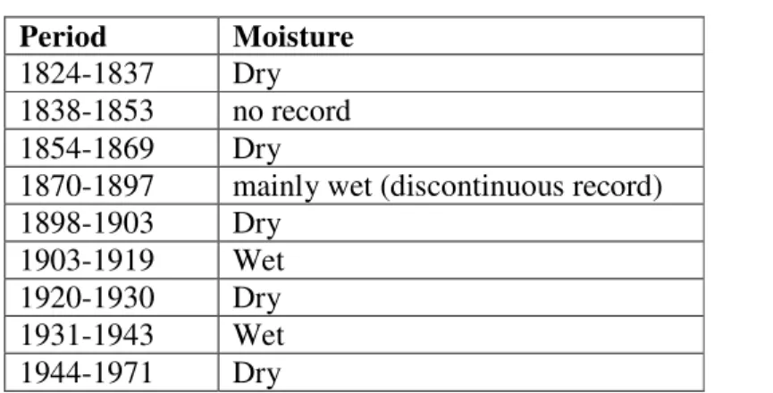
During the 19th and 20th centuries, there were long periods of drought alternated by wet years (See Table 1). Barbudans successfully coped with these droughts by largely abandoning commercial cultivation during dry years and expanding stock keeping, in essence creating a complex herding ecology to navigate the annual rainfall variation (Berleant-Schiller, 1983). During dry periods, livestock would assemble at the wells, being drawn particularly to the watering trough. Once there, Barbudans would then pen the cattle. During wet periods, the communal-land tenure allowed livestock to forage, breed unrestricted, and drink freely from the wells and sinkholes where water collected. When needed, Barbudans would round them up for butchering and export. It was also during wet years that Barbudans resumed crop production and restricted livestock movement with fencing. “Land use and tenure together have preserved the community from the hazards of drought and domination” (Berleant-Schiller, 1983, p. 87).
Table 1: Recurrent drought.
Period Moisture 1824-1837 Dry 1838-1853 no record 1854-1869 Dry
1870-1897 mainly wet (discontinuous record) 1898-1903 Dry
1903-1919 Wet 1920-1930 Dry 1931-1943 Wet 1944-1971 Dry
Source: Berleant-Schiller (1983, p. 86).
In addition to the disappearance of elder knowledge, Barbudans must also contend with environmental constraints as these relate to agriculture. Over the last 100 years in Barbuda, there has been an overall decline in annual rainfall (Berleant-Schiller, 1983). From 1953 to 1973, Barbuda’s annual rainfall averaged 88.6mm (34.9 inches), a decline of 12.7mm (five inches) from the previous 40 years. The drought correlated with a decline in cultivators: 168 cultivators working 280 acres in 1960 were reduced to 92 cultivators working 120 acres in 1971 (Berleant-Schiller, 1983, p. 303). More recent meteorological data collection indicates drought during 10 years between 1965 and 2000, using <705.87 mm (27.79 inches/year) of rain to define meteorological drought (Jackson, 2001, p. 9) with most rain being received as short intense bursts (Cooper & Bowen, 2001).
As Barbudans shift away from agricultural work in the commons, backyard gardens are taking on an increased function. Interviews in 2012 elicited Barbudans’ understandings and changing practices of subsistence agriculture as gardeners deal with drought and increased water salinization due to global climate change. Water salinization is a serious problem for Barbudans; one backyard gardener has salinity levels in his well that measured 10,000 ppm,
[The water is] so salty me not use it on the plants. Me use it to wet the ground. The side. Understand? On the leaf. Wet the leaf. If you noticed now I was using it heavy, heavy now. My wife decided to stop using this one and get this one from the government. That’s the government but that’s still salty than this. It’s so salty, Let me take you over here. Turn salty. See, kill it. (2012)1
This 60-year old gardener complains that even the government water is problematic for his garden. A July 2013 household survey of 30 homes reflects this sentiment. Eighteen households surveyed had access to government water. Of these 18, only nine actually use government water on their garden crops, with almost all specifying that they are careful not to put water on the leaves. In addition to careful use of government water, in order to cope with the salinity levels of both well water and government water, the same 60-year-old gardener quoted earlier put in a blank tank and catches additional rainwater with buckets,
That’s how much me like agriculture me get a tank for the garden. When the rain fall, we try to save the good water. (2012)
The salinity in Barbudan water even translates to language. Barbudans refer to two kinds of water: ‘good water’ and ‘pipe or well water’. Rainwater, which is collected from the roofs of houses and stored in cisterns or other containers, is ‘good water’. It is light, pure and without many dissolved solids, used for cooking and other household purposes depending on the amount available. It can even be used for bathing outside of drought conditions. The availability of good water is often dependent on a household having the funds to afford the construction of a cistern, something that eludes many Barbudans. Instead, Barbudans will also use containers ranging in size from a 55-gallon oil barrel to the 450-gallon and 1,000-gallon polyethylene containers.
For many years, pipe-borne water was limited and only some of the households located within the village proper had pipe water. Every house had its good water catchment system (drum or polythene container) and many even dug wells in the yard (alluded to earlier). Today, this system has been upgraded. Many households have pressure tanks and water pumps. The water is then pumped from the cistern or well, depending on the level of rainfall and therefore ensuring availability of good water.
Not all islanders can afford the cost of a black tank for their garden. One backyard gardener has instead created a rock-lined canal in his backyard to catch rainwater. The extensive garden makes use of every available space in the yard for rain-water collection, deploys raised fields, and boasts of an irrigation canal. He has adapted many gardening techniques he had learned from his native home of Guyana for decades. Other creative adaptations include the use of plastic sacks to hold moisture in the soil during the dry season.
Historical well assessment
During the summer of 2012, an assessment was conducted of the physical condition of the historical wells (e.g. Photo 1). In many places throughout the island, there are remnants of wells used during previous centuries for livestock, agriculture, and human uses, although these wells are used to a lesser extent today. In addition to the physical assessment of the well structures, measurements of the quality of the well water were made. The assessment of the water and well structure was compared with the anecdotal findings based on interviews with Barbuda residents.
Photo No. 1: Aerial photograph of Indigo Well.
Source: Rebecca Boger.
Figure 3 shows the locations of the historic wells. Most are located in the low-lying regions except for Pie Crust and Hall wells, which are along the edge of the Highland area. Many wells are located in the vicinity of Codrington and with increasing occurrence as one moves outside the village.
Figure 3: Locations of the historic wells.
Source: Rebecca Boger
Table 2: Comparison of well names.
Historic map well name
Modern map well name
1. Olin Owny (All In)
2. Low Pond William
3. Indigo Indigo
4. Jam Jam
5. Beazer Beazer
6. Spring Spring
7. Sam Spring Martello Tower 8. Unknown Spanish Point
9. Unknown Hall
10. Unknown Pie Crust
Table 3: Historical well use, present and past.
WELL NAME TRADITIONAL/HISTORICAL USE
PRESENT USE
Castle Water source for Codrington Castle, external domestic use. Probably not for cooking/drinking except in times of drought
Water source in severe drought and in cases of emergency or fire
Indigo For livestock, agriculture and washing laundry. Also used for
livestock management
(catching/culling)
Livestock watering, emergency use and livestock management
Beazer Watering livestock, agriculture, Livestock management
Watering livestock, agriculture, livestock management
Jam Well Watering livestock, agriculture, livestock management
Watering livestock, livestock management, construction and road works, emergency use Owny (All in) Watering, livestock, agriculture,
livestock management
Watering livestock, livestock management
Martello Tower General use associated with the military fortification
None
Spanish Well Important freshwater source for first European settlers (the oldest well on Barbuda)
None
Highland Agriculture, livestock Agriculture, livestock, occasional water source for hunters and campers
Sam Spring Watering livestock, agriculture Watering livestock Spring Agriculture, livestock watering,
washing laundry
Not used
Village General domestic water uses Emergencies William Domestic water uses, especially
washing laundry and a key fresh water source during severe drought
Currently dry and not in use, due to modern construction that has led to accumulated rubble Rolling Watering livestock, livestock
management, agriculture
Occasional water source for hunters and for agriculture Hall Watering livestock, livestock
management, agriculture
Not used
Pie Crust Watering livestock, livestock management, agriculture
Water source for hunters
Bumpy Watering livestock, livestock management, agriculture, washing laundry, meeting place for women
Watering livestock
The historic wells show varying degrees of condition with an overall assessment of a large amount of deterioration. Sluyter (2012) describes the shapes of seven wells (Low Pond, Jam, ‘New’ Indigo, Spring, Beazer, Olin, and Sam Spring). As shown in the air photo (Photo 1) of Indigo well, many of the features can be found: a wall encloses the well, a trough and a pen.
Table 3 shows whether the wells are still in use and for what purposes, including agriculture, livestock or human (drinking or other uses). Most were used for multiple purposes. Many are still in use, although to a lesser degree than in the past. Perhaps not surprisingly, fewer wells were used for livestock in the village itself, as well as at Martello Tower and Spanish Point wells to the south. The wells at Spanish Point and three wells in the village area were mainly used for drinking and other human consumption. About half the wells were used by people in the village and scattered around the island. Pie Crust in the Highland area is used by hunters and is currently highly overgrown with vegetation and in a deteriorating state. Bumpy Road well was a meeting place for women to do their laundry and spend the day working and socializing.
Salinity of groundwater
The salinity of the groundwater is of great concern for Barbuda as it impacts water usage for irrigation, livestock watering, human drinking and other purposes. With sea level rise, groundwater will be impacted by saltwater intrusion in addition to changing recharge rates from precipitation and human activities. Salinity affects soil chemistry, plant growth, and livestock yields (Bauder, Waskom, Sutherland, et al., 2011; Grattan, 2002) in addition to the ability of people to get enough water to meet their daily needs.
Figure 4 shows the salinity values in parts per million (ppm) when the wells were sampled in August 2012. All these wells were sampled within one week; however, rain events did occur which may have influenced the values and comparability of the salinity values in different locations around Barbuda. In general, the highest salinity values occur in the village area. Two notable exceptions are private wells near the lagoon with comparatively low values of 250 and 927 ppm. The highest value was found in a private well with a salinity value of 10,000 ppm. The owner expressed concern about the water in his well since he uses the water for his extensive backyard garden. Higher salinity values are found at Hall (2,000 ppm) and Highland (2,900 ppm) wells, near the Highland area.
Figure 4: Barbuda well salinity in parts per million (ppm).
Source: Rebecca Boger.
Discussion and recommendations
the Caribbean, the increasing reliance on food imports has caused a serious threat to local economies and human health, and there is a growing recognition that there is a need to change the negative association of farming and plantations with slavery in order for the younger generation to participate in local food production (Beckford & Campbell, 2013; Cave, 2013).
Figure 5: Barbuda wells: salinity change between 1966 and 2012.
Source: Rebecca Boger.
Although the water in many of the historical wells may not taste ‘good’ and be suitable for human drinking, most ground water around the island has potential for agricultural and livestock use. The initial testing in 2012 indicates that there is great potential for water use. However, the salinity values raise many interesting questions as to what trends there may be when compared with the 1966 report. Water withdrawals, long-term climate trends, recent weather at the time of testing, and saltwater intrusion contribute to salinity values. Surrounding construction could also impact the flow of groundwater and affect water levels and quality. These questions can only be answered through monitoring.
The historical wells are a material demonstration of a rich cultural heritage, documenting the creativity and resilience of Barbudans. In addition to this cultural richness, they are an important natural resource that provides access to water on a semi-arid island. Most of the historical wells are in serious disrepair, but a few have survived the passage of time.
Based on these initial findings, the water quality in the wells needs to be monitored regularly. Working with the Sir McChesney George Secondary School and the Barbuda Research Complex, high school students and City University of New York undergraduate and graduate students have begun to seasonally test the water in the wells to study the status and trends of the groundwater. Standardized techniques are being implemented to collect research quality data while data collection is being overseen by CUNY faculty and John Mussington, the Principal of Sir McChesney George Secondary School.
Could the historic wells assist Barbudans of today to make them more resilient in times of rapid climate change? Our pilot results show some positive data in support of this; but further testing is needed to actually see if our initial findings hold true. During 2014, pump recharge tests will be conducted and data loggers will be placed in several wells to monitor salinity, temperature, and depth to enhance the seasonal testing being conducted by the high school students. Results of the monitoring will be reported on in future publications.
Given its location, environment and geology, Barbudans will continue to face challenges in meeting food and water needs. Transdisciplinary collaboration among science, local ecological knowledge (LEK), and traditional ecological knowledge (TEK) can offer a potent tool for informed empowerment in grass roots planning towards future sustainability.
Acknowledgements
This project was made possible through the effort and gracious contributions of Barbudan community members, Brooklyn College students, and faculty members, especially Jennifer Adams, who volunteered their time and expertise.
References
Antigua and Barbuda. (2008). The Barbuda Land Act, 2007. Official Gazette 28(5), 1-18. Retrieved from www.faolex.fao.org/docs/pdf/ant78070.pdf
Bain, A., Kennedy, L., Burn, M., & Faucher, A.M. (2010). Archaeobotany, paleoclimatology, and archaeoentomology in Barbuda. New York: Barbuda Archaeological Research Center.
Bauder, T.A., Waskom, R.M., Sutherland, P.L., & Davis, J.G. (2010). Irrigation water quality criteria. Fact Sheet No. 0.506. Colorado State University Extension. Retrieved from
Beckford, C.L. & Campbell, D.R. (2013) Domestic food production and food security in the Caribbean: Building capacity and strengthening local food production systems. New York: Palgrave Macmillan.
Berleant-Schiller, R. (1977). The social and economic role of cattle in Barbuda. Geographical Review. 67(3), 299-309.
Berleant-Schiller, R. (1978). The failure of agricultural development in post-emancipation Barbuda: a study of social and economic continuity in a West Indian community. Boletin de Estudios Latino Americanos y del Caribe, 25, 21-36.
Burn, M.J., Bain, A., Kennedy, L., LeBlanc, A., Faucher, A., & Perdikaris, S. (2011). A late Holocene record of human eco-dynamics from Barbuda, Lesser Antilles. Presented at INQUA, Berne, Switzerland.
Campbell, P. (2006). Barbuda sand mining proves difficult to manage. Antigua Sun, 24 October.
Cave, D. (2013). As cost of importing food soars, Jamaica turns to the Earth, New York Times, August 3, 2013. Retrieved from
http://www.nytimes.com/2013/08/04/world/americas/as-cost-of-importing-food-soars-
jamaica-turns-to-the-earth.html?pagewanted=2&nl=todaysheadlines&emc=edit_th_20130804&pagewanted= all&_r=0
Cooper, B., & Bowen, V. (2001). Integrating management of watersheds and coastal areas in small island developing states of the Caribbean: National report for Antigua and Barbuda. Environmental Division, Ministry of Tourism and Environment.
Coram, R. (1993). Caribbean time bomb: The United States’ complicity in the corruption of Antigua. New York: William Morrow and Co.
Day, Dr. Charles William, Esq. (1852). Five years’ residence in the West Indies. London: Colburn and Co.
de Albuquerque, K., & McElroy, J. L. (1995). Antigua and Barbuda: a legacy of environmental degradation, policy failure and coastal decline. In: Supplementary Paper No. 5.
Washington, DC: USAID, EPAT/MUCIA.
Faucher, A.M., Guay, E.A., & Bain, A. (2011). Archaeobotanical studies on Barbuda, Preliminary Results from 2011. New York: Barbuda Archaeological Research Center. Fipps, G. (2003). Irrigation water quality standards and salinity management. Texas A&M
AgriLife Extension, B-1667, 4-03. Retrieved from
http://repository.tamu.edu/bitstream/handle/1969.1/87829/pdf_94.pdf?sequence=1 Food and Agriculture Organization. (FAO). Water quality evaluation. Retrieved from
http://www.fao.org/docrep/003/t0234e/t0234e01.htm
Grattan, S. R. (2002). Irrigation water salinity and crop production. Berkeley CA: University of California Agriculture and Natural Resources, Publication 8066.
Hambrecht, G., & Feeley, F. (2010). Archaeological investigations of Codrington Castle, Codrington, Barbuda. New York: Barbuda Archaeological Research Center. Hambrecht, G., & Look, C. (2009). 2009 Highland House survey report for the Barbuda
Historical Ecology Project. New York: Barbuda Archaeological Research Center. Hambrecht, G., Hicks, M., Djuknic, B., Khalsa, S., Williams, L., Witter, R., Riggle, J.,
Harris, D.R., (1965). Plants, animals, and man in the outer Leeward Islands, West Indies: An ecological study of Antigua, Barbuda and Anguilla. Berkeley CA: University of California Press.
IPCC. (2007). The Physical Science Basis. Contribution of Working Group I to the Fourth Assessment Report of the Intergovernmental Panel on Climate Change. Solomon, S., D. Qin, M. Manning, Z. Chen, M. Marquis, K.B. Avery, M. Tignor and H.L. Miller (Eds.), International Panel on Climate Change. Cambridge: Cambridge University Press. IPCC. (2013). Climate Change 2013: The Physical Science Basis. Working Group I
Contribution to the IPCC 5th Assessment Report - Changes to the Underlying
Scientific/Technical Assessment (IPCC-XXVI/Doc.4). International Panel on Climate Change. Retrieved from http://www.ipcc.ch/report/ar5/wg1/#.UnpRAiRTvjE
Jackson, I. (2001). Drought hazard assessment and mapping for Antigua and Barbuda: Post-Georges Disaster mitigation project in Antigua and Barbuda and St. Kitts and Nevis. Organization of American States.
Lowenthal, D., & Clarke, C. (2007). Triumph of the commons: Barbuda belongs to all Barbudans together. In J. Besson & J. Momsen, (Eds.), Caribbean land and development revisited (pp. 147-158). New York: Palgrave Macmillan.
McSweeney, C., New, M., & Lizcano, G. (2012). UNDP Climate Change Country Profiles: Antigua and Barbuda. Retrieved from
http://www.geog.ox.ac.uk/research/climate/projects/undp-cp/UNDP_reports/Antigua_and_Barbuda/Antigua_and_Barbuda.lowres.report.pdf
Northern Territory Government Department of Land Resource Management. (2014). Water quality guidelines. Retrieved from
http://lrm.nt.gov.au/water/ground/people/guidelines#.Ua0OT-tTvj
Perdikaris, S. (2009). 2009 Barbuda Historical Archaeology Report. New York: Barbuda Archaeological Research Center.
Perdikaris, S. (2010). 2010 Barbuda Historical Ecology Project Report. New York: Barbuda Archaeological Research Center.
Perdikaris, S. (2011). 2011 Barbuda Historical Ecology Project Report. New York: Barbuda Archaeological Research Center.
Perdikaris, S., Grouard, S., Hambrecht, G., Hicks, M., Mebane Cruz, A., & Peraud, R. (2013). The caves of Barbuda’s eastern coast: long term occupation, ethnohistory and ritual. Caribbean Connections, March, Volume III: 1.
Potter, A. E. (2011). Transnational spaces and communal land tenure in a Caribbean place: “Barbuda is for Barbudans.” PhD dissertation, Louisiana State University, Department of Geography and Anthropology.
Potter, A. E., & Sluyter, A. (2010). Renegotiating Barbuda’s commons: recent changes in Barbudan open-range cattle herding. Journal of Cultural Geography, 27(2), 129-150. Sluyter, A. (2012). Barbuda. In Black ranching frontiers: African cattle herders of the Atlantic
world, 1500-1900, pp. 98-139. New Haven CT: Yale University Press. Tweedy, M. A. (1981). History of Barbuda under the Codringtons: 1738-1833, PhD