Revista Geama (ISSN 2447-0740) | Souto et al., 2017 | Ciências Ambientais |103 Revista
www.geama.ufrpe.br
________________________________________________________________________________________________________________________
Camalaú-PB and their water and decadal variability
Thaís Jeruzza Maciel Póvoas Souto 1*, Sara Maria Gomes Pinheiro 2, Amanda Rodrigues Santos Costa 3,
Alcione Moraes de Melo 4, Raimundo Mainar de Medeiros 5 and Romildo Morant de Holanda 6
1,2Mestra em Engenharia Ambiental pela Universidade Federal Rural de Pernambuco – Recife, Pernambuco, Brasil.
*thaispovoas@hotmail.com
3,4Mestranda em Engenharia Ambiental pela Universidade Federal Rural de Pernambuco – Recife, Pernambuco, Brasil.
Artigo recebido em 11/11/2016 e aceito em 02/01/2017 ABSTRACT
Knowing the local climate is a necessary factor for evaluation of water resources, for various weather elements are indispensable throughout the hydrologic cycle. In this context, the objectives of this article are to estimate the climatic water balance and the balance sheet at decadal Thorntwaite and Mather method (1948.1955) to the city of Camalaú - PB and evaluate the main weir behavior in this area. Evapotranspiration is almost four times the amount of precipitation and evaporation is equal to precipitate volume. In climatological analysis of rainfall in the city under study, the months from January to May had the highest rainfall in the decade studied. In the year 2014 the months from March to May there were high rainfall rates. The climatic water balance demonstrates a water deficit of 740.3 mm/year for the year 2014 in the month of April 2014 was water surplus of 24.5 mm. In decadal water balance there is a water deficit of 710.1 mm/year and water surpluses do not occur in any month of the year studied. The variability of the large-scale El Niño (a) active in the study period influenced the rainfall and its location effects.
Keywords: Buoyancy, Climate, Hydrologic cycle.
Camalaú-PB e suas variabilidades hídricas e decadal
RESUMOConhecer o clima local é um fator necessário para avaliação dos recursos hídricos, pois vários elementos meteorológicos são indispensáveis em todo ciclo hidrológico. Nesse contexto, os objetivos desse artigo consistem em estimar o balanço hídrico climatológico e o balanço decadal pelo método de Thorntwaite e Mather (1948,1955) para o município de Camalaú - PB e avaliar o comportamento do principal Açude desta área. A evapotranspiração é praticamente quatro vezes o valor da precipitação e a evaporação é igual ao volume precipitado. Na análise climatológica dos índices pluviométricos no município em estudo, os meses janeiro a maio apresentaram os maiores índices pluviométricos na década em estudo. No ano de 2014 os meses de março a maio ocorreram altas taxas de precipitação. O balanço hídrico climatológico demonstra uma deficiência hídrica de 740,3 mm/ano para o ano de 2014, no mês de abril/14 ocorreu excedente hídrico de 24,5 mm. No balanço hídrico decadal ocorre uma deficiência hídrica de 710,1 mm/ano e os excedentes hídricos não ocorrem em nenhum mês do ano estudados. As variabilidades dos fenômenos de larga escala El Niño (a) atuantes no período de estudo influenciaram nos índices pluviométricos e dos seus efeitos local.
Revista Geama (ISSN 2447-0740) | Souto et al., 2017 | Ciências Ambientais |104 Introduction
Water is a primordial resource for sustaining life. Referring to "fresh water", this factor is interlinked with the multiple uses of activities developed through this resource, among them, supplies for human consumption, agroindustrial activities, Agriculture and livestock, irrigation and for ecosystems in accordance with Rebouças (2006).
According to Galvínio et al. (2006) in many regions, the availability of water resources is adequate but poorly distributed geographically and temporally. Stored water volumes are often used when they should provide regularized flows to meet well-defined demand and allow a balance between natural availability and water requirements.
Even in abundance, the spatial and temporal distribution of water on Earth is quite irregular, causing problems of excess in some places and shortages in others. According to Medeiros et al. (2014) to know the local climate for the evaluation of water resources is a determining factor, since several meteorological elements act on the variation and water availability. It can not be said if a climate is wet or dry knowing only the rainfall data, but it is necessary to know if the precipitation is greater or less than the water necessary for the evaporation and transpiration. Thus, precipitation and evapotranspiration are important climatic factors. According to Thornthwaite (1948) precipitation and evapotranspiration occur many times due to different weather causes in either quantity or distribution throughout the year. In some places the months of greatest precipitation occur after the month of greatest evaporation.
According to Albuquerque et al. (2009) the Northeast region of Brazil (NEB) exhibits semi-arid climate with diverse spatial and temporal variability of rainfall, with high rates of evaporation indexes.
According to the authors Souza Filho et al. (2006), the oscillations and their climatic fluctuations cause significant impacts in the socioeconomic sector.
Medeiros et al. (2014) shows that the climatic variations of a region or micro-region are decisive in the choice of agricultural activities developed and the type of management to be established. In which the climatic classification was carried out from the Climatological Water Balance for estimated CAD values of 125, 100, 75, 50 and 25 mm. The soil water storage capacity did not interfere in the Municipal Climate Classification, however, soils with different CAD did not provoke increases in the rates of potential
evapotranspiration, nor did they alter the values of water deficiencies and surpluses.
According to Medeiros et al. (2012) have shown that taking decisions aimed at the conservation of natural resources makes it necessary to raise as much hydrological, climatological, agro-climatic and agro-ecological information as possible. The analysis of the climate and its availability of the surface and underground water resources of the municipality of Cabaceiras, the climatic characterization was carried out by means of the survey of the climate and time as precipitation, wind, relative humidity of the air, water balance and resources Surface water and groundwater.
According to Macedo et al. (2013) estimated the climatological and decadal water balance for the city of Monteiro - PB and analyzed the behavior of the potions pond in the referred municipality. Regarding the thermal conditions, the lowest values of average temperature occur from June to August, and evapotranspiration and evaporation are higher than the registered rainfall indices.
The water reality associated with the climatic factors instigates several researchers to carry out studies involving the water balance, since this becomes necessary in the accounting of the amount of water that enters and leaves the soil. The traditional water balance of Thornthwaite and Mather (1948, 1955) is an agrometeorological instrument used to characterize the moisture factor that includes potential evapotranspiration and monthly precipitation in such a way that there is no water left in the soil for plant use. Güntner et al. (2004) applies a simple deterministic water balance model for several reservoirs in the State of Ceará, these reservoirs are grouped into classes according to the storage capacity. Galvin et al. (2006) used the water balance to analyze the impact of anthropogenic actions on the surface runoff of the Epitacio Pessoa water basin located in the municipality of Boqueirão-PB.
Ufoegbune et al. (2011) presented estimates of the water balance in Lake Oyan in Northwest Nigeria, with the specific objectives of obtaining the monthly mean rainfall, seasonal rainfall patterns, evaporation estimation in the Oyan reservoir, potential and actual evapotranspiration, as well as the amount of water Surplus that is readily available for infiltration and runoff, as well as determining the amount of recharge available per area.
The objective of this study is to evaluate the estimation of the climatological water balance and the decadal water balance for the city of Camalaú-PB and to analyze the behavior of the monthly volumes of the weir in the referenced area.
Revista Geama (ISSN 2447-0740) | Souto et al., 2017 | Ciências Ambientais |105 Material and Methods
The Camalaú municipality is located in the
Microregion of the same name and in the Agreste Paraibano Mesoregion of the State of Paraíba, with a territorial area of 109 km² representing 0.1937% of the State, 0.007% of the Northeast Region and 0.0013% of the Brazilian territory. According to IBGE (Brazilian Institute of Geography and Statistics), in 2010 its population was estimated at 26,000 inhabitants, the municipality under study is limited by the municipalities of Campina Grande, Massaranduba, Matinhas, São Sebastião de Lagoa de Roça, Mounts, Puxinanã and Esperança. The county seat has the geographical coordinates at Latitude: 07 ° 10'15 '' South and Longitude: 35 ° 51'13 '' West of Greenwich with altitude of 634 meters.
The monthly and annual data of precipitation referring to the period of 52 years of data observed (1962-2014), to characterize rainfall and its relation with meteorological phenomena, such as El Niño and La Niña. From the data were obtained graphs of annual variations, monthly and seasonal averages of precipitation to represent satisfactorily the pluviometric regime of the region, the data provided by the Executive Agency for Water Management of the State of Paraíba (AESA, 2015) and by the Superintendence of Northeast Development (SUDENE, 1990).
The precipitating factors for the study area are: Intercropping Convergence Zone (ZCIT) and the contributions of High Level Cyclic Vortex systems (VCANs) when in activity on the NEB. In addition to the effects of the northeast trade winds aided by the formation of the South Atlantic Cyclonic Vortexes (VCAS) and the convective clusters strengthened by the Dipole Pattern (PD) in the Tropical Atlantic Ocean and the wave disturbances in the field of the trade winds, Droughts, floods, floods, floods, overflowing rivers, streams, dams, barriers, dams, ponds, lakes and wells.
Four types of climatic classifications were used by the method of Thorntwaite and Mather (1948, 1955) for the periods: normal; rainy; regular and dry. In the normal period the classification was of type C1A'S2a '; In the rainy period there is a classification of type C2D'a '; For the rainy season the classification was of the type C2B'2 a 'and in the dry period was classified with C2E'Ra'. In accordance with the classification of Köppen has a climate of the BSh type.
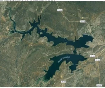
According to the Executive Agency for Water Management of the State of Paraíba (AESA), the Camalú dam is the main reservoir that supplies this municipality and has a maximum capacity of
46,437,520 m³, Figure 1. The main use of its waters is for water supply and irrigation.
With regard to the soils, in the long and low slopes of the smooth undulating relief planosols occur, poorly drained, average natural fertility and salt problems; Tops and high slopes, brunos non-calcic soils, shallow and high natural fertility; Tops and high slopes of the corrugated relief occur the Podzolic, drained and average natural fertility and the Residual Elevations with Littoral, shallow, stony soils and average natural fertility CPRM (2005).
Figure 1 - Spatial location of the Camalaú dam in the municipality of Camalaú-PB.
Source: Google Earth, 2013. According to Cavalcanti, et al., (1994, 2006) the meteorological information used: maximum air temperature, minimum air temperature and average air temperature, thermal amplitude were estimated by the software "Estima_T", developed by the applied meteorology nucleus Federal University of Campina Grande-PB (UFCG).
Climatic elements such as relative air humidity, wind intensity, predominant wind direction, evapotranspiration, evaporation, cloud cover, total sunshine were estimated by multiple linear regression lines and simplified interpolations were performed and monthly and annual data were used Period from 1962 to 2014, and monthly data on the volumes of the Camalaú dam and precipitation related to the same period, provided by the Executive Agency for Water Management of the State of Paraíba.
The climatological water balance was used in the monthly scale for a mean year, that is, the cyclical water balance, elaborated from the climatological normals of average temperature and precipitation.
The most used technique to work with global water balance data from the climatological point of view is the water balance of Thornthwaite and Mather (1948, 1955) where the program
Revista Geama (ISSN 2447-0740) | Souto et al., 2017 | Ciências Ambientais |106 developed by Medeiros (2014) was used. By
counting the natural water supply to the soil, through rainfall (P), and the atmospheric demand, by potential evapotranspiration (ETP), considering a maximum possible level of storage (CAD). The water balance provides estimates of the real evapotranspiration (ETR), water deficit (DEF), water surplus (EXC) and effective soil water storage (MRA), and can be elaborated from daily to monthly scale according to Camargo (1971). The water capacity of the field (CAD) used was 100 mm.
Results and Discussion
The evaporation was of 466.8 mm. These evaporative indices are related to the variations of the wind intensities, incidence of total insolation, of the cloud cover of said municipality. The water deficit in the period from 2003 to 2013 was 710.1 mm and there were no water surpluses, showing that the rainfall indices did not exceed the field capacity of the period studied in accordance with Table 1.
Table 1 - Climatological water balance by the method of Thornthwaite and Mather (1955) for the municipality of Camalaú-PB in the decade of 2003 to 2013 (Authors, 2017). Param eters /Month s Precipi tation Temper ature Evapor ation Evapotrans piration Defici ency Sur plus Jan. 64,1 24,7 64,1 116,6 52,4 0 Feb. 55,3 24,5 55,3 104,6 49,3 0 Mar. 83,8 24,2 83,8 110 26,2 0 Apr. 80 23,9 80 100,9 20,9 0 May 73 22,9 73 91,8 18,9 0 June 39,7 21,9 39,7 76,8 37,1 0 July 25,1 21,3 25,1 73,7 48,7 0 Aug. 7,5 21,7 7,5 77,6 70,1 0 Sep. 1,7 22,7 1,7 86,8 85,2 0 Oct. 14,1 23,8 14,1 105,1 90,9 0 Nov. 7,2 24,5 7,2 111,8 104,7 0 Dec. 15,4 24,8 15,4 121,1 105,7 0 Yearl y 466,8 23,4 466,8 1176,9 710,1 0
Legend: Historical precipitation (mm); Mean temperature (° C); Actual evaporation (mm); Potential evapotranspiration (mm); Water deficit (mm); Water surplus (mm).
Figure 2 shows the decadal water balance (2003-2013) of the municipality of Camalaú by the method of Thornthwaite and Mather (1948, 1955). It is observed that in the decade studied only water deficits predominated with monthly fluctuations ranging from 18.9 (May) to 105.7 (December) mm.
Table 2 represents the water balance calculation for the year 2014. There is an annual precipitation of 444.2mm. Annual average temperature of 23.3 ° C The annual evaporation was 419.7 mm. The annual evapotranspiration of 1,160 mm. The water deficit was 740.3 mm and there was a water surplus of 24.5 mm in the month of April.
Figure 2 - Decadal Water Balance (2003-2013) of the municipality of Camalaú - PB, by the method of Thornthwaite and Mather, (1948, 1955).
Source: Authors, 2017. Table 2 - Climatological water balance by the method of Thornthwaite and Mather (1955) for the municipality of Camalaú - PB for the year 2014 (Authors, 2017). Param eters /Mont hs Precipi tation Tempe rature Evapor ation Evapotran spiration Defici ency Sur plus Jan. 2,5 24,4 2,6 111,8 109,1 0 Feb. 23,1 24,1 23,1 100 76,9 0 Mar. 66 23,8 66 105,9 39,9 0 Apr. 223,3 23,6 98,8 98,8 0 24,5 May 61,7 23 88,5 92,9 4,4 0 June 5,2 21,9 43 77,8 34,8 0 July 12,4 21,2 28,5 73 44,5 0 Aug. 3,8 21,5 13,8 76,9 63,1 0 Sep. 3,8 22,5 9 85,9 76,9 0 Oct. 6,7 23,8 9,3 104,8 95,6 0 Nov. 35,7 24,5 36,5 111,6 75,1 0 Dec. 0 24,7 0,5 120,5 120 0 Yearly 444,2 23,3 419,7 1160 740,3 24,5
Comparing the decadal results with the result of the year 2014 stands out a reduction in the rainfall indexes by around 10%, a reduction in the average temperature of 0.1 ° C occurred a reduction of 47.1 mm in the actual evaporation and in the evapotranspiration reduction Of 169 mm, there was a surplus of 30.3 mm in the water deficiencies as well as 24.5 mm in the water
Revista Geama (ISSN 2447-0740) | Souto et al., 2017 | Ciências Ambientais |107 surpluses. It should be noted that in the year
2014 El Niño was moderate and climatic conditions compared to that of the decade were anomalies.
Figure 3 shows water deficiencies between May and March, soil water withdrawal from May to October, water replenishment and water surplus in the month of April.
Figure 3 - Monthly climatological monthly water balance (2014) of the municipality of Camalaú - PB, by the method of Thornthwaite and Mather, 1955.
Source: Authors, 2017. Because of the water deficiency verified in Figures 2 and 3, the volume of the Camalaú dam, whose maximum capacity is 46,437,520 m³, presented values less than 50% of its maximum capacity, from 2006 to 2016, figure 4, with Except for the year of 2009, where water levels were above normal. The highest value of the volume of the Açude in this period was superior to 50 million cubic meters. At present, the lowest value of water deficit is found (Figure 5). The lowest evaporative indices occurred according to Tables 1 and 2.
Figure 4 - Volume stored in the last 10 years.
Source: AESA, 2016. Figure 5 shows the monthly variability of the volume stored in the last seven months, covering the period from June 2015 to March 2016, between February and March 2016, the weir had
stored 1,254 m3, this volume was caused by rainfall Above the normal range within the area of your pelvis.
According to Lira et al. (2015) Northeast Brazil is a region characterized by high rates of evapotranspiration, low annual rainfall, and semiarid climate in much of its area of coverage. In this way the superficial water scarcity and the heterogeneous temporal distribution of rainfall, the development of the anthropic activities becomes quite compromised, having as consequence serious economic and social damages. With this, the fixation of man in the region is hampered by the reduction in the quality of life, caused mainly by the decrease in agricultural production and the generation of financial resources.
Figure 5 - Monthly volume in the last seven months.
Source: AESA, 2016. Conclusions
Evapotranspiration is almost four times the precipitation value and evaporation is equal to the precipitated volume.
In the climatic analysis of the pluviometric indices in the municipality of Camalaú the months of January to May presented the highest rainfall indices in the decade under study. In the year 2014 the months of March to May occurred high precipitation rates.
The climatic water balance shows a water deficit of 740.3 mm/year for the year 2014, in April 14 there was a water surplus of 24.5 mm. In the decadal water balance a water deficiency of 710.1 mm/year occurs and the water surpluses do not occur in any month of the year studied.
The variability of El Niño (a) large-scale phenomena during the study period influenced the rainfall indexes and their local effects.
References
ALBURQUERQUE, I. F.; FERREIRA, J. N.; SILVA, M. G.; DIAS, M. F. Tempo e Clima no Brasil. São Paulo: Oficina de textos, p.280. 2009.
Revista Geama (ISSN 2447-0740) | Souto et al., 2017 | Ciências Ambientais |108 CAMARGO, A. P. Balanço hídrico no Estado de
São Paulo. Campinas: IAC, 28p. (Boletim Técnico, 116), 1971.
CPRM - Serviço Geológico do Brasil. Projeto cadastro de fontes de abastecimento por água subterrânea. Diagnóstico do município de Camalaú, estado da Paraíba. Recife: CPRM/PRODEEM, 2005. Disponível em: <<http://www.cprm.gov.br/rehi/atlas/paraiba/rel atorios/MONT120.pdf>>. Acesso em: 05/05/2017. CAVALCANTI, E. P.; SILVA, V. P. R.; SOUSA, F. A. S. Programa computacional para a estimativa da temperatura do ar para a região Nordeste do Brasil. Revista Brasileira de Engenharia Agrícola e Ambiental, Brasil, v. 10, n. 1, p. 140-147, 2006.
CAVALCANTI, E. P.; SILVA, E. D. V. Estimativa da temperatura do ar em função das coordenadas locais. IN: Congresso Brasileiro de Meteorologia. 8. 1994. Belo Horizonte, Anais... Belo Horizonte: SBMET, 1994, v.1, 154-157pp. GALVÍNCIO, J. D.; SOUSA, F. A. S.;
SRINIVASAN, V. S. Balanço hídrico à superfície da bacia hidrográfica do açude Epitácio Pessoa. Revista Brasileira de Recursos Hídricos. Volume 11 N.3 JUL/SET 2006, 135-146.
GÜNTNER, A.; KROL, M.; ARAÚJO, J. C.; BRONSTERT, A. Simple water balance modelling of surface reservoir systems in a large data-scarce semiarid region. Hydrological Sciences–Journal–des Sciences Hydrologiques, v. 49, n.5, 2004, p.901-918.
KÖPPEN, W.; GEIGER, R. “Klimate der Erde. Gotha: Verlag Justus Perthes”. Wall-map 150cmx200cm. 1928.
LIRA, R. M. De; NASCIMENTO, A..; SOARES, J.; MARIA, J.; BARNABÉ, C.; RAMALHO, H. (2015). A utilização de águas de qualidade inferior na agricultura irrigada. Revista Geama
Environmental Sciences, 3(1), 62–83.
MACEDO, M. J. H.; MEDEIROS, R. M.; SILVA, V. M. A.; SOUSA, F. A. S.; Análise Climatológica e Balanços Hídricos no Município de Monteiro, 7º Encontro Internacional sobre Águas, Universidade Católica do Recife, Anais, Recife, PE. 2013.
MEDEIROS, R. M. Elaboração do balanço hídrico em planilha eletrônica em conformidade com Thornthwaite e Mather (1948, 1955). 2014.
MEDEIROS, R. M.; SILVA, D.C GOMES FILHO, M. F. Armazenamento de água no solo no município de Lagoa Seca – PB. I Workshop Internacional Sobre Água no Semiárido Brasileiro Campina Grande – PB. 2014.
MEDEIROS, R. M. Estudo agrometeorológico para o estado da Paraíba. 120p. 2013. Edições avulsas
MEDEIROS, R. M.; BORGES, C. K.; LIMA, A. T.; MELO, A. S. Avaliação das condições hídricas por meio do panorama de mudanças climáticas em Cabaceiras-PB. Rev. Bras. Agric. Irrigada v. 6, n.3, p. 227 – 239. 2012.
REBOUÇAS, A. C. Águas doces no mundo e no Brasil. In: Águas doces do Brasil: Capital ecológico, uso e conservação. Org. Rebouças, Aldo da C. Braga, Benedito. Tundisi, José Galizia. 3° ed. Editora Escrituras. São Paulo. p. 01-35. 2006.
SOUZA FILHO, F. A.; MOURA, A. D. Memórias do Seminário Natureza e Sociedade nos Semi-Áridos. Fortaleza: Banco do Nordeste do Brasil; Fundação Cearense de Meteorologia e Recursos Hídricos, p.332, 2006.
THORNTHWAITE, C. W. An approach toward a rational classification of climate. Geographical Review, New York, v.38, n.1, p.55-94, 1948. THORNTHWAITE, C. W.; MATHER, J. R. The
water balance. Publications in Climatology – Drexel Institute of Technology. New Jersey, v.8, n.1, p.1-86, 1955.
UFOEGBUNE, G. C.; YUSUF, H. O.; ERUOLA, A. O.; AWOMESO, J. A. Estimation of Water Balance of Oyan Lake in the North West Region of Abeokuta, Nigeria. British Journal of Environment & Climate Change, v.1, n.1, p.13-27, 2011.