Sveriges lantbruksuniversitet ISBN (print): 978-91-576-9236-8
Institutionen för skoglig resurshushållning ISBN (elektroniskt): 978-91-576-9237-5 901 83 UMEÅ
www.slu.se/srh
Tfn: 090-786 81 00
Computer-based tools for supporting forest
management. The experience and the expertise
world-wide
by Borges, J.G., Nordström E.M.,Garcia-Gonzalo, J., Hujala T.
and Trasobares, A. (Eds.)
Report of Cost Action FP 0804 Forest Management Decision Support Systems (FORSYS)
Sveriges lantbruksuniversitet ISBN (print): 978-91-576-9236-8
Institutionen för skoglig resurshushållning ISBN (elektroniskt): 978-91-576-9237-5 Utgivningsort: Umeå
Utgivningsår: 2014
Computer-based tools for supporting forest
management. The experience and the expertise
world-wide
by Borges, J.G., Nordström E.M.,Garcia-Gonzalo, J., Hujala T.
and Trasobares, A. (Eds.)
Report of Cost Action FP 0804 Forest Management Decision Support Systems (FORSYS)
Preface
Computer-based tools for supporting forest management. The experience and the expertise world-wide answers a call from both the research and the professional communities for a synthesis of current knowledge about the use of computerized tools in forest management planning. According to the aims of the Forest Management Decision Support Systems (FORSYS) (http://fp0804.emu.ee/) this synthesis is a critical success factor to develop a comprehensive quality reference for forest management decision support systems. The emphasis of the book is on identifying and assessing the support provided by
computerized tools to enhance forest management planning in real-world contexts. The book thus identifies the management planning problems that prevail world-wide to discuss the architecture and the components of the tools used to address them. Of importance is the report of architecture approaches, models and methods, knowledge management and participatory planning techniques used to address specific management planning problems. We think that this synthesis may provide effective support to research and outreach
activities that focus on the development of forest management decision support systems. It may contribute further to support forest managers when defining the requirements for a tool that best meets their needs.
The first chapter of the book provides an introduction to the use of decision support systems in the forest sector and lays out the FORSYS framework for reporting the experience and expertise acquired in each country. Emphasis is on the FORSYS ontology to facilitate the sharing of experiences needed to characterize and evaluate the use of computerized tools when addressing forest management planning problems. The twenty six country reports share a structure designed to underline a problem-centric focus. Specifically, they all start with the identification of the management planning problems that are prevalent in the country and they move on to the characterization and assessment of the computerized tools used to address them.
The reports were led by researchers with background and expertise in areas that range from ecological modeling to forest modeling, management planning and information and communication technology development. They benefited from the input provided by forest practitioners and by organizations that are responsible for developing and implementing forest management plans. A conclusions chapter highlights the success of bringing together such a wide range of disciplines and perspectives.
This book benefited from voluntary contributions by 94 authors and from the involvement of several forest stakeholders from twenty six countries in Europe, North and South America, Africa and Asia over a three-year period. We, the chair of FORSYS and the editorial
committee of the publication, acknowledge and thank for the valuable contributions from all authors, editors, stakeholders and FORSYS actors involved in this project.
Ljusk-Ola Eriksson2, José G. Borges1, Jordi Garcia-Gonzalo1, Eva-Maria Nordström2, Teppo Hujala3 and Antoni
Trasobares4
1Centre for Forest Research, School of Agriculture, University of Lisbon, 2Dept. of Forest Resource Management- SLU, 3Finnish Forest Research Institute, 4Institute of Terrestrial Ecosystems, Department of Environmental Sciences, ETH Zurich
Contents
1 Computerized decision support tools to address forest management planning problems:
history and approach for assessing the state of art world-wide ... 3
2 Design and use of computer-based tools supporting forest planning and decision making in Austria ... 16
3 The use of forest decision support systems in Brazil ... 33
4 The development and use of forest management decision support systems in Canada ... 48
5 The Design and Use of Forest Decision Support Systems in Chile ... 71
6 The design and use of forest management decision support systems in China ... 84
7 The design and use of forest decision support systems in Denmark ... 95
8 Design and use of forest decision support systems in Estonia ... 109
9 The use of forest decision support systems in Finland ... 116
10 Forest decision support tools in Germany ... 134
11 The design and use of forest decision support systems in Greece... 152
12 Decision support systems for the sustainable management of forests in Britain ... 168
13 Computer-based tools for supporting forest management in Hungary ... 190
14 The structure and use of computer-based tools for forest management in Ireland ... 208
15 Computer-based tools to support decisions in forest planning in Italy ... 227
16 The design and use of forest decision support systems in Morocco ... 251
17 Decision support systems in the Dutch forestry sector... 267
18 Development and use of forest decision support systems in Norway ... 280
19 Computer-based tools for supporting forest management in Portugal ... 296
20 Computer-based tools for supporting forest planning and management in Slovenia ... 320
21 The design and use of computer-based tools for supporting forest management in the Russian Federation ... 341
23 Computer-based tools for supporting forest management in Spain ... 383
24 The design and use of forest decision support systems in Sweden ... 403
25 The design and use of forest decision support systems in Switzerland ... 420
26 The design and use of forest decision support systems (DSS) in Turkey ... 445
27 The design and use of forest decision support systems in the USA ... 460
28 Addressing forest management planning problems with computerized tools. A synthesis of the experience world-wide ... 484
3
1 Computerized decision support tools to address forest
management planning problems: history and approach for
assessing the state of art world-wide
Ljusk Ola Eriksson1, Borges J. G. 2
1Swedish University of Agricultural Sciences2 Forest Research Centre, School of Agriculture, Technical University of Lisbon
1.1
Introduction
1.1.1 Why decision support tools in forestry?
At the Association of European Operational Research Societies conference in Helsinki in 1992, Andrés Weintraub, Professor at the University of Chile, concluded that operations research methods had already been successfully applied in forestry. Indeed, simulation and optimization algorithms have been included in software to guide forest managers since the 1960s, and now at least 100 computerized decision support systems (DSS), with various levels of sophistication, have been developed and are being widely used in numerous countries. There are several reasons for the popularity and abundance of these systems. Most importantly, forest management is highly complex. Forestry has multiple social, ecological and economic aspects, since forests not only produce timber but also provide a wide range of other products and services. As physical and social conditions vary enormously around the world it is hardly surprising that diverse systems have been designed and adapted to address forest management problems associated with varying local management systems and socio-ecological conditions. Furthermore, forest managers’ decisions can affect large geographical areas for a long time. Actions today determine the decision space for decades to come, and treatments in one part of a forest may affect what is done in other parts, now or in the future. Thus, they must be carefully implemented after considering numerous factors simultaneously; a task that is greatly facilitated by an appropriate DSS. In addition, forest management is becoming more complex, partly because of increasing awareness of the need for sustainability (Hahn and Knoke 2010), hence the needs for advanced forest DSS are also likely to increase. Sustainability was initially linked solely to timber production, in what was often termed “sustained yield forestry”. However, in the 1960s increased attention was directed towards the multiple services supplied by forests, hence “multiple use forestry” strategies emerged. However, the development and implementation of the strategies were regarded as matters for experts. Consequently, use of the DSS developed at the time required high expertise, until awareness arose of the need for participation by local communities and other stakeholders. Since the Rio World Summit in 1992, participatory decision-making has been seen as a key element for the sustainable use of resources, now generally termed Sustainable Forest Management (SFM). Parallel to environmental legislation and increased public involvement in decisions concerning the use of forest resources, the work of forest experts and the expectations towards their work have become more complex and diverse (Tipple and Wellman 1991; Tindall et al. 2010). The involvement of stakeholders in the process has thus profound influence on forest DSS development and use. There can be little doubt that forest policy makers and managers will increasingly rely on DSS to balance the diverse and increasing demands placed on forest ecosystems – inter alia delivering renewable raw materials, sustaining biodiversity,
4
promoting human health, protecting drinking water resources, and providing buffers to resist natural hazards – while at the same time addressing climate change uncertainty.
The purpose of this publication is to describe, as comprehensively as possible (given space and time limitations), modern DSS used in forestry, and the kind of management problems they are intended to address. To this end there are chapters from 18 European countries and 8 countries in North America, Asia and Africa, each analyzing the problems associated with forestry and the DSS used in attempts to tackle them. Even though the main focus of the publication is “full” DSS, other computerized tools are also considered due to the lack of DSS for all the prominent planning problems. A concluding chapter summarizes the relation between management problems and available DSS, indicating areas that are well covered and problems that warrant further attention in DSS development.
This introductory chapter will continue by describing what is meant by a DSS. The concept could be, and has been, used to refer to almost anything that could aid decision-makers, but here it is used more restrictively, within the framework of its use in literature associated with forest DSS. Finally, the way that the work on the individual country reports was conducted is presented, including the definition of the dimensions defining the forest management problem types.
1.1.2 What is a DSS?
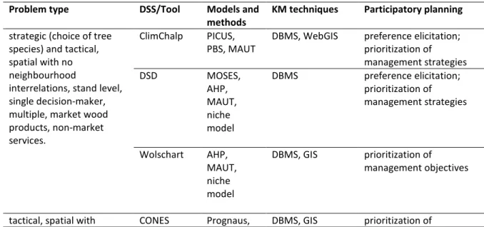
In a computer science context, a DSS is often defined as a model-based software system that contains four components: (i) a language system (LS) that enables users to communicate with and use the DSS (ii) a presentation system (PS) for displaying its outputs (iii) a knowledge system (KS) for storing all the input information and (iv) a problem processing system (PPS) (Burstein and Holsapple 2008). Users of the system can be decision-makers, developers or anyone that adds to or taps the knowledge system (or data models). The relationship between them is illustrated in Figure 1.
5
Figure 1. Schematic diagram of the main components of a DSS.
Three of the main components (the LS, PS and KS) are representative systems: the “communicative” system (LS) consists of all messages to the DSS from the user; the presentation system (PS) consists of all messages from the DSS to the user; and the knowledge system (KS) consists of all knowledge that is collected in the form of data or models held in the DSS. The knowledge system is sub-divided into three components here: one that holds data (e.g. data on the forest concerned); one that holds models (e.g. models for predicting growth and yield); and one that holds methods (e.g. for calculating key statistics or a solver for optimizing a problem). The integrative part of the DSS is the problem processing system (PPS). The task of the PPS is, simply, to solve the problems the user has specified. In doing so the PPS must receive information coming from the LS, integrate the data, models and methods, and communicate the result to the PS.
1.2
Reviews of methods and tools
Abundant literature describes components of the KS, and these are of course the subjects of specialized publications devoted to data, models and methods, respectively (some of which specifically consider forest DSS). Notably, the (rapidly evolving) remote sensing field, with special relevance for obtaining detailed forest data, has been presented by Packalén et al. (2008), while methods for assessing landscape attributes have been reviewed by Kätsch (2008). Various categorizations and descriptions of forest growth and yield models have been presented. Gratzer et al. (2004) focus on models describing the spatio-temporal development of forests, whereas Peng and Wen (2006) and Pretzsch et al. (2008) employ a more general classification scheme. Pretzsch et al. (2008) also provide a few examples of computer applications. Fontes et al. (2010) discuss empirical, process-based and hybrid
6
growth and yield models and assess 25 computer programs with process-based models in use in Europe. Some of the software presented by Pretzsch et al. (2008) and Fontes et al. (2010) qualify as DSS in the sense of the term used here, although the focus is on software that integrate various kinds of knowledge components.
Classical (exact) optimization methods (linear programming, dynamic programming etc.) with reference to their use in DSS have been reviewed by Garcia (1990). Heuristic (probability-based) methods came to the fore in the 1990s, particularly as attempts to address spatial problems became prevalent. Sessions et al. (2007) provide a short introduction of heuristic methods related to different planning problems. Bettinger and Kim (2008) review heuristic approaches for spatial (endogenous) optimization. Baskent and Keles (2005) and Hof and Haight (2007) review applications of both exact and heuristic methods for optimizing spatial problems. Another class of methods is represented by those that handle multiple criteria. Mendoza and Martins (2006), Diaz-Balteiro and Romero (2007), Diaz-Balteiro and Romero (2008), and Ananda and Herath (2009) review methods for multiple criteria decision analysis (MCDA) and studies involving such methods. Martins and Borges (2007) review methods that address collaborative planning and they discuss tools for integrating participatory planning.
Several reviews of forest DSS were presented in the 2000s. For example, seven were presented in Issue 1 (Volume 49) of Computers and Electronics in Agriculture (2005), and four were reviewed by Reynolds and Schmoldt (2006). The most comprehensive analysis of forest DSS to date has been provided by Johnson et al. (2007), who characterized 32 systems according to the decision-making factors they consider (biodiversity indicators supported, forest disturbances, silviculture etc.) and includes 15 in-depth studies of successes and failures of DSS applications. Johnson et al. (2007) also cite reviews of DSS capabilities to assist with National Forest plans (Schuster et al. 1993), ecosystem management (Mowrer 1997, Rauscher 1999), biodiversity in county-level planning (Johnson and Lachman 2001). Reynolds et al. (2008) review 10 systems.
Several general conclusions can be drawn from the literature of forest DSS development and use. Firstly, they are likely to become increasingly important as they can furnish tailored forest management solutions; standardized silviculture is not desirable as it reduces diversity and cannot be adapted to meet changing needs as policies evolve (Gadow et al. 2008). Adaptive management of multi-purpose forestry not only requires sophisticated systems for large-scale analyses but also capabilities for iterative on-demand, on-site and ad hoc analyses together with stakeholders. Secondly, social aspects are increasing in importance (Johnson, Gordon et al. 2007; Reynolds et al. 2008), encouraging the application of MCDA, group decision-making, participation and more internet-based applications (Reynolds and Schmoldt 2006). Thirdly, it is anticipated that there will be increasing needs for sophisticated DSS capable of meeting demands for systematic and transparent analysis associated with increases in both social complexity (increases in numbers of players, and both the intricacy and contentiousness of their relationships) and informational complexity (the degree to which available data and relationships must be structured and organized) (Johnson et al. 2007). Fourthly, as a response to these needs there also appears to be a trend towards more comprehensive, general-purpose systems supplanting more single-purpose systems (Rauscher et al. 2005; Reynolds et al. 2008). Fifthly, as a consequence of the increased scope
7
of the systems it is suggested that it might be more appropriate for them to host modular programs capable of running either separately or interactively, rather than a single, massive integrated application (Reynolds and Schmoldt 2006). This line of development points out the significance of model and algorithm libraries and transferable metadata, which raises the future requirements of knowledge management within forestry DSS to a new, “intercontextual” and “intersystemic” level. Sixthly, despite the increasing complexity of the systems, they must be adapted to the needs and competences of their target users and be transparent in order to avoid the “Black box” syndrome (Johnson et al. 2007; Reynolds et al. 2008). Hence, adaptive design cycles, in which systems are used, tested and adjusted in successive iterations (Rauscher et al. 2005), may be valuable.
1.3
Forest problem dimensions
As outlined above, substantial experience has been gained in the development and use of forest DSS, and various facets of currently available systems have been widely reviewed. However, some aspects that have not been thoroughly addressed previously are considered in more detail here. Most importantly, as also mentioned above, the forest DSS are not so much in focus as the capacities of DSS in relation to the problems they are intended to resolve. The country reports begin with descriptions of forest management problems and then link existing DSS to the problems, thereby indicating applications for which forest DSS appear to be useful, gaps in DSS capabilities, and potential areas of know-how transfers. Hopefully, this approach should facilitate better understanding of the properties of DSS, their strengths and their shortcomings. Further, the scope of forest DSS that are covered in the literature cited above is rather limited or biased. Apart from the analysis by Johnson et al. (2007), only 19 unique systems have been considered, and even Johnson et al. (2007) only consider systems applied in North America. Taking that into account and considering that the website of the FORSYS project alone hosts about 60 systems (http://fp0804.emu.ee/wiki/index.php/Main_Page), mostly of European origin, extensive fields of DSS application remain to be described and analyzed.
Due to the diverse backgrounds of the participants of this project it was imperative to establish a common nomenclature for characterizing the problem dimensions. After a lengthy process the definitions in Table 1 were laid down (here slightly edited). There are of course innumerable ways of characterizing a planning problem. The general principles applied here were that the dimensions should be: (i) comprehensive, i.e. cover all planning situations of interest (ii) comprehensible, i.e. fairly easy to identify, using terms that are reasonably well established in the literature for describing planning situations (iii) able to relate to some characterization of DSS and (iv) easy to compare among regions and forest owner categories. The last two of these principles warrant further comment. Regarding principle (iii), an assessment of the extent to which a certain dimension actually could meaningfully be related to existing DSS was made. The literature in the area also gave guidance. An implication of principle (iv) was that the dimensions considered would be rather abstract and not content-specific (e.g. not defined in terms of the managed species or in terms of a specific objective like avoiding wind-throw and avalanches or promoting aesthetic values). A further motivation for applying this level of abstraction is also the potential flexibility of DSS, e.g. from the perspective of a particular DSS the ability to deal
8
with neighbourhood relationships may be the critical issue, whereas it masters the analysis of risks of fire, wind-throw and avalanche just as well.
Temporal scale: The division of the planning process into a hierarchy consisting of what are often called strategic, tactical and operational planning levels is well established in most forestry communities. However, the term “strategic” (in particular) may have other connotations than those intended here (Cea and Jofre 2000; Hoogstra and Schanz 2008). Therefore, the more neutral time terms long, medium, and short are used. The use of time scales, rather than the strategic, tactical and operational trio could also facilitate the classification of planning problems for smaller private forest owners since the trio has developed in corporate settings. To the extent that the terms strategic, tactical and operational are used in the book, they have the same meaning as long-term, medium- and short-term planning. Still, you will find the terms strategic, tactical and operational in the definitions applied here agree well with those provided by, for instance, Gunn (2007), Church (2007) and Epstein (2007), respectively.
Spatial context: As is evident from the studies cited above, spatial aspects are frequently addressed in forest planning. Spatial phenomena can be characterized in diverse ways regarding the distribution of the objects concerned, their shape, connectivity, and their geometry (e.g. line or polygon). The decision here was to have as few categories as possible (three). One indicates that location is unimportant. A typical problem of this type is the standard harvest scheduling problem (see e.g. Ware and Clutter (1971) for an early example). The other two categories indicate spatial significance: one indicating that neighbouring stands are in some way affected by actions in another stand, and the other indicating no such connection, i.e. when considering actions in a given stand there is no need to know what is done in neighbouring stands. Examples of the former type of problem relate for instance to throw problems, where actions in one stand affect the risk of wind-throw in neighbouring stands (Meilby et al. 2001; Forsell et al. 2011). An example of the latter type of problem is the typical zoning problem, where constraints are set for stand treatments within zones or for the zones per se but where actions in one stand do not affect the behaviour of other stands (Nalli et al. 1996; Nordstrom et al. 2011) .
It should be noted that these distinctions are different from those applied in the Spatial Decision Support Knowledge Portal (SDS; www.spatial.redlands.edu/sds/), where the categories None, Neighbourhood and Global are used. Global refers to general landscape structures, e.g., numbers of patches, patch size distributions or ecological networks, whereas Neighbourhood is characterized by local interaction. This means that our category Spatial with no neighborhood interrelations falls under None according to SDS. Furthermore, it is a matter of interpretation whether our category Spatial with neighbourhood interrelations covers either the Global and Neighbourhood SDS categories, or only Neighbourhood. There is a certain degree of vagueness in our term neighbourhood that one should be aware of when considering the results.
Spatial scale: The implicit focus of the entire project is on forest management and support tools that help decision-makers in that endeavour. The scope of the FORSYS COST Action has been formulated as dealing with any “…forest management planning problem /that/ involves the definition of the timing and location of forest management options in a unit of
9
forest land over a planning horizon, in order to approximate or optimize management objectives…”. From that perspective, the forest level is of primary interest. However, for some forest owners, the forest decomposes into a few stands, or problems are approached on a stand-by-stand basis. In some countries, due to the ownership structure, the stand level may be very important compared to forest-level planning. In order to describe this kind of management problem the stand level must also be represented. More problematic is the regional/national level. The objective of this publication is not to cover problems and systems pertaining to the sphere of forest policy. However, in some countries forest policy is virtually synonymous with forest management. We would thus ignore some interesting cases if this level was excluded.
Decision-making dimension: As described above, SFM refers to forestry undertaken with considerations of its effects on different stakeholders and future generations. Thus, there are generally numerous participants, but their level of participation may vary substantially, and SFM can be exercised even if there is essentially only one active decision-maker, provided his/her decisions are governed by appropriate certification schemes, laws and regulations. It is not unanimously defined when a single-decision-maker planning problem actually becomes a multiple-decision-makers problem; is it sufficient to acquire information from stakeholders or does it require collegial group decision-making? In this book, two categories of decision-making were applied: One or more decision-makers (for all classes of multiple-stakeholder forestry, including SFM) and Single-owner (for cases where a single owner makes decisions largely autonomously, although it should be noted that the decisions of even single owners may be heavily constrained by regulations). Indeed, an interesting aspect of the association between problems and DSS is, of course, to what extent the DSS are adapted to multi-stakeholder situations.
Objectives dimension: The most common objective cited in the forest economics literature is to maximize the net present value of the forest, as generally operationalized by the Faustmann formula. For some owners of small forest holdings this could be a valid, single objective. However, for larger forest holdings, or holdings in more complex social settings, different kinds of values must be balanced. In this book, such situations are classified as multi-objective problems. One could also note that multiple objectives could also refer to different aspects of one item, such as the financial value and harvest profile over time of timber production (Hallefjord et al. 1986). In the DSS this might technically be handled as a single objective problem, for instance by expressing all goods and services in one commensurate kind.
Goods and services dimension: The goods and services, market and non-market categories are of interest from several viewpoints; notably they indicate the kind of forestry being pursued, its purposes, and the consequent requirements for any DSS used. If the primary target is to secure fresh water a different DSS will probably be required (or different modules of the same DSS) than if the main goal is to optimize timber production in plantation forestry. The Goods and services dimension may or may not have implications for the Objectives dimension as discussed above.
One aspect that is not found in Table 1 is that of risk and uncertainty. It was excluded as a problem-defining dimension because, basically, no problems in forestry are completely free
10
of uncertainty. Thus, attempting to categorize uncertainty would involve rather subjective assessments of the degrees of uncertainty regarding future developments in pertinent variables.
Table 1. Definition of problem dimensions Temporal scale
• Long-term (strategic) management planning. Planning horizon extending over more than 10 years.
• Medium-term (tactical) management planning. Planning horizon extending from two to 10 years.
• Short-term (operational) management planning. Planning horizon extending over one year or less, typically including planning periods of one month or less.
Spatial context
• Spatial with neighbourhood interrelations. The interactions of decisions made for
neighbouring stands (or other areal units) are of importance, i.e. a decision made for one stand may i) constrain decisions for neighbouring stands or ii) influence the outcome of decisions made for neighbouring stands.
• Spatial with no neighbourhood interrelations. Locations of forest operations are of
importance, but it is assumed that a decision made for one stand does not constrain decisions for neighbouring stands or influence the outcome of decisions made for neighbouring stands. • Non-spatial. Stands may be aggregated into strata or analysis units without considering their
mutual locations. There is no concern with locational specificity or neighbourhood interrelations.
Spatial scale
• Stand level. Focused on units with homogeneous ecological, physiographic and
development features.
• Forest level. Focused on forest landscapes with several stands managed for (a)
common purpose(s).
• Regional/national level. Focused on sets of landscapes that may all be managed for
different objectives.
Decision-making dimension
• A single decision-maker makes the decision on his/her own, e.g. the forest owner.
• One or more decision-makers have the power to decide. In addition, there can be other parties (stakeholders) with no formal decision-making power that are influenced or may influence the decision.
Objectives dimension
• Single. The management planning problem addresses one and only one objective.
• Multiple. The management planning problem addresses two or more objectives, any pairs of which could be conflicting, complementary or neutral with respect to each other.
11 Goods and services dimension
• Market wood products. The management planning problem addresses the supply
of wood products that are traded in the market (roundwood, pulpwood, biomass…) • Market non-wood products. The management planning problem addresses the
supply of non-wood products that are traded in the market (fruits, cork…)
• Market services. The management planning problem addresses the supply of
services that may be traded in the market (recreation, hunting, fishing…)
• Non-market services. The management planning problem addresses the supply of services that are typically not traded in the market (public goods, aesthetic values, water,
biodiversity…)
1.4
Data for the country report chapters
The sources for the country reports vary considerably between countries (Table 2). Almost all country reports are based on consultations with developers and users (China, Germany, Russia, and USA are exceptions). To some extent this reflects the size of the country; to cover, for instance, China or USA requires methods other than for Switzerland. However, this does not necessarily mean that such contacts have not been made, only that they have not been explicitly stated in the report. In almost all cases authors refer to their own experience (and for the exceptions – Greece, Ireland, Italy, Morocco, the Netherlands and South Africa – this does not exclude such experience, only that it is not explicitly stated). In a few cases, special questionnaires have been prepared for the reports, notably in Brazil, Germany, and Portugal. Additionally, a few countries (Austria, Russia and South Africa) have referred to questionnaires without stating their exact numbers. It could be noted that sometimes it is difficult to draw a clear line between consultations and questionnaires (Denmark is such an example). All reports contain references to various documents. The account in Table 2 is not necessarily complete; where not already stated, one could for most countries add “other written material”.
Table 2. Data sources used for the country report chapters.
Country Consultation with developers a) Consulta-tion with
users a) b) Questio-nnaire c) Documents d)
Austria x (a) x (a) x (various organizatio ns)
x (wiki, reports, journals)
Brazil x (a) x (a) x (22) x (technical and scientific references) Canada x (a) x (a) x (internet sources, reports, journals) Chile x (a) x (a) x (articles, websites)
China x (laws and regulations, reports)
Denmark x
(interviews) x (Danish and international journals) Estonia x (a) x (a) x (laws, regulations, technical documents) Finland x (a) x (a) x (scientific papers, plan documents, wiki)
12 Country Consultation with developers a) Consulta-tion with
users a) b) Questio-nnaire c) Documents d)
Germany x (36) x (scientific papers, reports) Great Britain x (a) x (a) x (scientific papers, reports)
Greece x x (scientific papers, reports, proceedings) Hungary x (a) x (a) x (legal cases, other written material) Ireland x x x (scientific papers, reports, conference
proceedings)
Italy x x x (articles, reports, dissertations) Morocco x x (user guides, test cases, other written
material)
Netherlands x (5) x (reports, articles, plans) Norway x (a) x (a) x (scientific papers, internet)
Portugal x (a) x (a) x (24) x (peer and non-peer reviewed publications)
Russia x (various
organizatio ns)
x (scientific and technical publications, internet, laws and regulations) Slovenia x (a) x (a) x (articles, reports)
South Africa x x (to users) x (STSM, other written material)
Spain x (a) x (a) X (text books, forest plans, manuals, web pages, other written material)
Sweden x (a) x (a) x (scientific papers, reports) Switzerland x (a) x (a) x (articles, proceedings, reports) Turkey x (a) x (a) x (articles, reports)
USA x (literature, internet, past surveys)
a) x = consultation is stated; (a) = includes also authors as developers or users. b) Number in brackets designates number of contact, if given.
c) Specifically prepared for this book, otherwise referred to Documents. Number in brackets designates number
of responses, if given.
d) wiki refers to the FORSYS wiki on forest DSS (http://fp0804.emu.ee/wiki/index.php/Main_Page); STSM refers
to short term scientific missions conducted within FORSYS.
It is to be expected that the quality of the database for the reports varies between countries. Some countries have used peer reviewed journals for decades to document experiences whereas others, for different reasons, have had limited access to international publication. Some of the material consists of reports that, if it was not for the insights of the authors, would otherwise be difficult to access. The very broad as well as deep exposition of problems and tools presented here relies ultimately on the unique group of experts that is gathered around this publication.
13
1.5
The publication process
The work was initiated in early 2010. A publication with country reports was identified as a powerful tool for transferring know-how between the countries involved in the FORSYS COST Action. Material on the appropriate format was circulated, and during the steering group meeting in April 2010 it was decided to issue country report templates, together with explanations and instructions. At the same meeting a special task committee (STC) consisting of Antoni Trasobares (Spain), Jordi Garcia-Gonzalo (Portugal), Teppo Hujala (Finland) and Eva-Maria Nordström (Sweden), was established with Jose Borges (Portugal) as Coordinator. One of the first actions of the STC was to disseminate a form to guide presentations of preliminary country reports at the next meeting in November in Brussels 2010. During that meeting about 20 short presentations on problems and DSS were delivered and final revisions were made to the templates and instructions. From that point on, the work followed the set procedures. The STC was heavily involved in the work from the beginning. The members distributed responsibility for maintaining close contact with representatives of the participating countries among themselves to ensure there were well-defined channels of communication with the authors of each report. The STC reviewed the country reports and compiled feedback for authors twice, during two-day meetings in spring and autumn 2011. Most country reports underwent several rounds of revision to ensure that they all followed the same format.
This volume rests on the contribution of more than 100 authors and the dedicated work of the STC. It is without doubt the most comprehensive account of forest planning problems and forest DSS ever published.
References
Ananda, J. and G. Herath (2009). A critical review of multi-criteria decision making methods with special reference to forest management and planning. Ecological Economics 68(10): 2535-2548.
Baskent, E. Z. and S. Keles (2005). Spatial forest planning: A review. Ecological Modelling 188(2-4): 145-173. Bettinger, P. and Y.-H. Kim (2008). Spatial Optimisation – Computational Methods. In: K. v. Gadow, Pukkala, T. (eds). Designing Green Landscapes. Dordrecht, Springer. 15: 111-135.
Burstein, F. and C. W. Holsapple (2008). Handbook on decision support systems 1. Berlin ; London, Springer. Cea, C. and A. Jofre (2000). Linking strategic and tactical forestry planning decisions. Annals of Operations Research 95: 131-158.
Church, R. (2007). Tactical-level forest management models. In: Handbook of Operations Research in Natural Resources : International Series in Operations Research & Management Science.
Diaz-Balteiro, L. and C. Romero (2007). Multiple Criteria Decision-Making in Forest Planning: Recent Results and Current Challenges. In: C. R. A. Weintraub, T. Bjørndal, R. Epstein (eds) Handbook of Operations Research in Natural Resources. New York, Springer: 472-488.
Diaz-Balteiro, L. and C. Romero (2008). Making forestry decisions with multiple criteria: A review and an assessment. Forest Ecology and Management 255(8-9): 3222-3241.
Epstein, R. (2007). Harvest operational models in forestry. In: Handbook of Operations Research in Natural Resources : International Series in Operations Research & Management Science.
14
Fontes, L., J. D. Bontemps, et al. (2010). Models for supporting forest management in a changing environment. Forest Systems 19: 8-29.
Forsell, N., P. Wikstrom, et al. (2011). Management of the risk of wind damage in forestry: a graph-based Markov decision process approach. Annals of Operations Research 190(1): 57-74.
Gadow, K. v., T. Nuutinen, et al. (2008). Adaptive Design of Forested Landscapes. In: K. v. Gadow, Pukkala, T. (eds) Designing Green Landscapes. Dordrecht, Springer. 15: 3-31.
Garcia, O. (1990). Linear programming and related approaches in forest planning. New Zealand Journal of Forestry Science 20(3): 307-331.
Gratzer, G., C. Canham, et al. (2004). Spatio-temporal development of forests - current trends in field methods and models. Oikos 107(1): 3-15.
Gunn, E. (2007). Models for strategic forest management. In: Handbook of Operations Research in Natural Resources : International Series in Operations Research & Management Science.
Hahn, W. A. and T. Knoke (2010). Sustainable development and sustainable forestry: analogies, differences, and the role of flexibility. European Journal of Forest Research 129(5): 787-801.
Hallefjord, A., K. Jornsten, et al. (1986). A Long-Range Forestry Planning Problem with Multiple Objectives. European Journal of Operational Research 26(1): 123-133.
Hof, J. and R. Haigh (2007). Optimization of Forest Wildlife Objectives. In: C. R. A. Weintraub, T. Bjørndal, R. Epstein (eds) Handbook of Operations Research in Natural Resources. New York, Springer: 404-418. Hoogstra, M. A. and H. Schanz (2008). The future orientation of foresters: An exploratory research among Dutch foresters into the prerequisite for strategic planning in forestry. Forest Policy and Economics 10(4): 220-229.
Johnson, K. N., S. Gordon, et al. (2007). Conserving creatures of the forest: A guide to decision making and decision models for forest biodiversity. Corvallis, OR, Oregon State University, College of Forestry.
Kätsch, C. (2008). Assessing Landscape Attributes. In: K. v. Gadow, Pukkala, T. (eds) Designing Green Landscapes. Dordrecht, Springer. 15: 79-108.
Martins, H. and J. G. Borges (2007). Addressing collaborative planning methods and tools in forest management. Forest Ecology and Management 248(1-2): 107-118.
Meilby, H., N. Strange, et al. (2001). Optimal spatial harvest planning under risk of windthrow. Forest Ecology and Management 149(1-3): 15-31.
Mendoza, G. A. and H. Martins (2006). Multi-criteria decision analysis in natural resource management: A critical review of methods and new modelling paradigms. Forest Ecology and Management 230(1-3): 1-22. Nalli, A., T. Nuutinen, et al. (1996). Site-specific constraints in integrated forest planning. Scandinavian Journal of Forest Research 11(1): 85-96.
Nordstrom, E. M., L. O. Eriksson, et al. (2011). Multiple Criteria Decision Analysis with Consideration to Place-specific Values in Participatory Forest Planning. Silva Fennica 45(2): 253-265.
Packalén, P., M. Maltamo, et al. (2008). Detailed Assessment Using Remote Sensing Techniques In: K. v. Gadow, Pukkala, T. (eds) Designing Green Landscapes. Dordrecht, Springer. 15: 53-77.
Peng, C. H. and X. Z. Wen (2006). Forest simulation models. Computer Applications in Sustainable Forest Management: Including Perspectives on Collaboration and Integration. Dordrecht, Springer. 11: 101-125.
15
Pretzsch, H., R. Grote, et al. (2008). Models for forest ecosystem management: A European perspective. Annals of Botany 101(8): 1065-1087.
Rauscher, H. M., K. Reynolds, et al. (2005). Decision-support systems for forest management. Computers and Electronics in Agriculture 49(1): 1-5.
Reynolds, K. and D. Schmoldt (2006). Computer-aided decision making. Computer Applications in Sustainable Forest Management. Dordrecht, Springer. 11: 143-169.
Reynolds, K. M., M. Twery, et al. (2008). Decision Support Systems in Forest Management. In: F. Burstein and C. W. Holsapple (eds) Handbook on decision support systems 2. Berlin, Springer.
Sessions, J., P. S. Bettinger, et al. (2007). Heuristics in Forest Planning. In: C. R. A. Weintraub, T. Bjørndal, R. Epstein (eds) Handbook of Operations Research in Natural Resources. New York, Springer: 431-448. Tindall, D. B., H. W. Harshaw, et al. (2010). Understanding the social bases of satisfaction with public participation in forest management decision-making in British Columbia. Forestry Chronicle 86(6): 709-722. Tipple, T. J. and J. D. Wellman (1991). Kaufman,Herbert Forest Ranger 30 Years Later - from Simplicity and Homogeneity to Complexity and Diversity. Public Administration Review 51(5): 421-428.
Ware, G. O. and J. L. Clutter (1971). Mathematical Programming System for Management of Industrial Forests. Forest Science 17(4): 428-&.
16
2 Design and use of computer-based tools supporting forest
planning and decision making in Austria
Harald Vacik1, Manfred J. Lexer2, Johannes Scholz3, Bernhard Wolfslehner4, Anna Maria
Köck5, Michael Granitzer6
2.1
Introduction
2.1.1 Socio-economic and ecological environment
Austria is a predominantly alpine Central European country with an area size of 83,871 km² and a forest cover of 47.6%. According to the Austrian Forest Inventory 2007/ 2009 the forest cover has a total area of 3.92 million ha (BMLFUW 2010). Austria is situated in the Central European climatic zone (moderate, humid), however, the eastern part and the eastern foothills of the Alps are more continental Pannonian climate (hot, dry). The main tree species is Norway Spruce (Picea abies L. K.) with a total share of 61.2% (growing stock in productive forests). According to the Austrian Forest Inventory, the share of broadleaved trees has increased in recent years, within these beech and hardwoods such as maple, ash or hornbeam play a major role. The forest ownership is 53% small private forests (<200 ha), 32% private estates (>200 ha) and 15% federal forests. At present, Austria's forest resource is underutilized because of economic, social and technical reasons. The current annual harvest is around 18-20 million m³, while the total increment is estimated at 31 million m³ per year. The mean stand volume is around 300 m³/ha in commercial forests whereas the mean annual increment is 9 m³/ha. The forestry sector’s contribution to gross domestic product growth was about 2.1% in 2003 according to the most recent calculations (€ 4.8 billions). Therefore, 0.4% was accounted for by forest management, 0.9% by wood processing and 0.8% by paper and cardboard production and processing. Some two-thirds of all Austrian citizens live in rural regions, and forests as a major renewable resource play an important role in this context. From a nature conservation point of view slightly more than one million hectares of forest are identified as protected forests in accordance with nature conservation law and in natural forest reserves.
The Austrian Forest Act (amended BGBl.I Nr. 55/2007) attributes five functions to forests: (1) productive function (i.e., sustainable timber production)
(2) protective function (i.e., protection against erosion and natural hazards
1 corresponding author: Harald Vacik, [email protected], University of Natural Resources and Life Sciences, Vienna, Austria,
Department of Forest- and Soil Sciences, Institute of Silviculture, Peter Jordan Str. 82, 1190 Vienna.
2[email protected], University of Natural Resources and Life Sciences, Vienna, Austria.
3[email protected],Institute of Geoinformation and Cartography, Research Group Geoinformation, University of Technology,
Vienna, Austria.
4[email protected], University of Natural Resources and Life Sciences, Vienna, Austria.
5[email protected], ZBW – German National Library of Economics, Leibniz Information Centre for Economics, Kiel, Germany. 6[email protected], Scientific Director, Know-Center Graz, Austria.
17
(3) welfare function (i.e., the protection of environmental goods like drinking water) (4) recreational function (use for recreation) and
(5) habitat function (protection of forests as a habitat for living organisms.
The overall principles of the Act are: i) the preservation of forest area ii) the preservation of the productivity of forest sites and their functions and (iii) the preservation of yields for future generations (sustainability). Accordingly, forest sites must not be destroyed, degraded or damaged and any clearings have to be reforested. The forest may not be used for any other purpose than for forest culture. More importantly, protected forests have to be treated without impairment of the protective functions. If the preservation of a protective function or water procurement is demanded, forests are formally banned by the authority. For such a ban, forest management prescriptions have to be prescribed and forest owners have a right to apply for subsidies for implementing forest measures and to ask for compensation from the beneficiaries of the forest. Timber production is described as the main use of Austrian forests. At the same time, this use is under the constraint of sustainable management. For this purpose, immature stands (as a rule no younger than 60 years) must not be felled. Stricter forest management regulations are in force on a provincial level in the mountainous parts of Austria. For instance, clear cuts exceeding 0.5 ha have to be approved by the authority with special supervision for felling in protected forests. As regards social aspects, everybody has the right of access to any forest for recreational purposes during daytime, no matter if it is private or public property.
2.1.2 Forest management problems
In the following, an overview is given on prevalent problem types in Austrian forest management, and how these relate to the key problem types of FORSYS. Furthermore, information is provided on who is involved in the respective planning processes as well as on the relevance of computer-based decision support tools.
2.1.3 Selecting options for forest conversion
Since the 19th century, extensive areas of natural broadleaved and mixed forests in warm
and partly dry lowlands have been transformed into conifer plantations either dominated by Norway spruce (Picea abies (L.) Karst.) due to its superior productivity and wood quality or to pine forests (Pinus sylvestris (L.)). Substantial areas of these secondary coniferous forests are close to their ecophysiological limits and are particularly vulnerable. In warmer and eventually drier future climates, an increased frequency of drought periods and generally an increasing inter-annual variability in climate biotic and abiotic risks for these forests is expected (Lindner et al. 2010). Furthermore, multiple rotations of Norway spruce may lead to soil compaction and increased soil acidification, which in turn may affect nutrient cycling depending on site conditions. To improve crop reliability and to reduce economical and ecological risks, the conversion of pure Norway spruce and pine stands into mixed-species stands, which are better adapted to the specific site conditions, is often recommended (Spiecker et al. 2004). In debating the likely impacts of global climate change and possible adaptation strategies, much emphasis has been placed on secondary conifer forests. The development of sound stand conversion programmes is currently one of the key issues in silvicultural research and forest management planning. Risk rating current stands, support in selecting appropriate species mixtures as well as the treatment of current stands are major issues calling for science-based knowledge and decision support.
18
This problem type can be characterized with the following dimensions: strategic (choice of tree species) and tactical, spatial with no neighbourhood interrelations, stand level, single decision-maker, multiple, market wood products, non-market services.
2.1.4 Managing mountain forests
In mountain forests, various ecosystem services have to be met such as producing timber, protecting infrastructure and settlements from natural hazards like avalanches, mud flow and torrents, preventing fragile mountain sites from soil erosion, and providing sustained yield of high quality water resources. Silvicultural treatment plans for such multi-purpose mountain forests need to be tailored to stand and site conditions, and prioritized management objectives. In this context, close-to-nature forestry with single stem and group selection systems attempt to balance these often conflicting objectives. However, standard approaches applying silvicultural and forest engineering measures independently are not sufficient. Particularly challenging is the treatment of mature stands scheduled for regeneration. Decision-making about harvesting and natural regeneration of mountain forests with cable yarding systems requires therefore the consideration of several key issues: (a) meeting minimum economic constraints of harvesting operations (b) considering mid- to long-term effects of damages to the residual stand and to advance regeneration (c) providing suitable conditions for establishment of natural regeneration (d) controlling the mechanical stability of the stand (e) utilizing the growth potential of the stand. Additionally, results from the Austrian Forest Inventory and of recent game damage monitoring have revealed severe impacts of game on forest regeneration (BMLFUW 2010). More than two-thirds of all Austrian forests are browsed beyond the capacities of natural regeneration.
This problem type can be characterized with the following dimensions: tactical, spatial with neighbourhood interrelations, stand level, more than one decision-maker, multiple, market wood products, non-market services.
2.1.5 Utilization of timber resources
Timber production is the main use of Austrian forests. The current harvest is around 18-20 million m³, while the total increment is estimated at 31 million m³ per year. At present, Austria’s forest resource is underutilized because of economic, social and technical reasons. As 53% of the forest ownership is small private forests (<200 ha) mostly comprising a low level of technical equipment and silvicultural know-how, the possibilities for wood mobilization are limited. Therefore, substantial efforts are made to identify strategies for increased utilization of timber. On the other hand, logistics related to timber harvesting, logging and transport have been improved in the last decades, e.g. with innovations in real-time spatial localization (using mobile phones, GPS, web technologies) and optimization procedures. In addition, the analysis and design of wood-based value chains has raised increased scrutiny, i.e. the sequence from forestry production, to harvest and transport, and industrial processing and trade. This issue comprises the sustainability impact assessment of forest wood chains (Wolfslehner et al. 2011), flexible supply chains and logistics (Bajric et al. 2010), and smart use of small-diameter hardwood in Austria (Huber at al. 2010). From time to time, storm, snow and other weather-related disasters with their subsequent mass propagation of forest pests cause quite significant, but usually regionally limited, economic damage and a huge amount of salvaged timber. In recent years, storm and bark beetle damage has been particularly severe. The year 2003 saw one of the highest levels of wood
19
loss due to bark beetle in Austria since records started more than 50 years ago. In this context, huge amounts of timber needed to be processed from the forest to sawmills risking reduced timber quality and imbalances on the timber market.
This problem type can be characterized with the following dimensions: short to mid-term, spatial, regional/national level, more than one decision-maker, multiple, market wood products.
2.1.6 Objectives
This report aims to provide an overview of the design and use of computer-based tools supporting forest planning and decision making in Austria. In detail we are focusing on:
(1) An inventory of decision support tools in forest management planning, with a focus on the key problem types listed
(2) a description of the key features regarding architecture, development, use of models, methods and knowledge management techniques
(3) lessons learned on the use of computer-based decision support tools so far
2.2
Materials and methods
Information on the use of forest Decision Support Systems (DSS), models and methods used in forest DSS, knowledge management (KM) techniques applied and participatory approaches utilized is mostly related to universities and research institutions in Austria. In addition, computer-based decision support tools have been identified by a survey among ministries, local forest authorities and forest owner associations. With a set of structured and open questions it was possible to identify the use of existing computer-based decision support tools within the organizations contacted, relevant contact persons and the way in which these tools are used in forest management planning problems. Some of the material presented here has been already introduced to the FORSYS Wiki (http://fp0804.emu.ee/wiki/index.php/Main_Page). The following institutions can be named as relevant for developing and applying computer-based tools in forest management in Austria.
At the Institute of Silviculture, Department of Forest and Soil Sciences at the University of Natural Resources and Life Sciences, strong emphasis is set on the development and application of DSS in natural resource management. The Know-Center is a nationally funded application-oriented research centre primarily concerned with knowledge management and knowledge technologies. As a knowledge technology provider, a number of techniques and tools developed at the Know-Center can suit forestry decision support systems, but have not been applied to this domain yet. The Knowledge Management Institute at Graz University of Technology is concerned with the technical aspects of knowledge management and with web-based mechanisms for knowledge sharing and transfer. The Research and Training Centre for Forests, Natural Hazards and Landscape (BFW) is a multidisciplinary research and training institution of the Federal Government of Austria. Applications developed at BFW support knowledge transfer and provide practical advice to forest owners.
20
2.3
Results
2.3.1 DSS related to forest conversion
ClimChalp: A web-based DSS tool for silvicultural planning and decision-making in low-elevation secondary Norway spruce forests was developed to help forestry extension staff to explore adaptation options for silviculture in secondary Norway spruce forests in Austria (Vacik et al. 2010). ClimChalp has a strong focus on the question of suitable stand treatment programmes for currently existing Norway spruce stands at low elevation sites naturally supporting mixed broadleaved forest types given a particular set of management objectives (represented by a set of indicators focusing on timber production, ecophysiological tree suitability, timber yield, harvesting and silvicultural costs, carbon sequestration, biodiversity and groundwater recharge). The tool has three main components: the information base, the DSS generator and a graphical user interface (GUI) which is particularly designed to support the consultation process of the forestry extension services for small-scale private landowners by reducing the necessary user input to a minimum. Stand treatment programmes over 100 years for initial stand types had been designed and were simulated with the forest ecosystem model PICUS under current climate and four transient regionalized climate change scenarios.
The hybrid approach of PICUS v1.42, henceforward referred to as PICUS, aims to bring together the abilities of a 3D gap model (Lexer and Hönninger 2001) in simulating structural diverse forest stands on an individual basis with process-based estimates of stand level primary productivity. In general, PICUS offers a detailed projection of stand dynamics under the simulated management and climate conditions, including individual-tree information on diameter and height. This core concept forms the nucleus of a modular simulation framework integrating a process-based soil module, a management module (Seidl et al. 2005) as well as a thermo-energetic process module of Norway spruce bark beetle infestation (Seidl et al. 2007). PICUS is sensitive to changes in temperature, precipitation, radiation and vapour pressure deficit. Previous analyses found a realistic response to the climatic gradients in the complex terrain of the European Alps, both in terms of species dynamics (Lexer and Hönninger 2001; Didion et al. 2009) and productivity (Seidl et al. 2005). The user of ClimChalp is supported in comparing decision alternatives by means of multi-criteria analysis and a combined approach of visualized and verbal qualitative ratings. ClimChalp was designed to support the members of the forestry extension staff in Lower Austria. Currently the applicability and use of the tool is explored by a small number of experts within the local authority in order to give feedback for further development and a broader use within the organisation.
DSD: The decision support system DSD v1.1 (Decision Support Dobrova) was developed for the analysis and selection of silvicultural treatment alternatives for Scots pine (Pinus
sylvestris L.) and Norway spruce (Picea abies (L.) karst.) stands in southern Austria (Lexer et
al. 2005). The tool is particularly designed to support the forest resource management Figure 1. Climchalp -
supporting the management of Norway Spruce Forests
21
consultation process with forest landowners in the course of the management of secondary coniferous forests. In close cooperation with the local forest authorities, a generic model of the consultation process had been developed (Vacik et al. 2004a). DSD v1.1 supports a planning process which covers the phases of decision-making: (i) identification of current states regarding site and stand conditions (ii) identification of owners’ expectations and preferences regarding a set of objectives (iii) selection and evaluation of management alternatives. The stand treatment programmes for representative stand types were designed to support a variety of future target species mixtures. The growth and yield simulator MOSES (Hasenauer 2000) was used to simulate these stand treatment programmes over a period of 30 years; the model output was combined with expert knowledge and economic parameters and used to inform the indicator system. MOSES is a distance-dependent tree model which is well suited to studying the effects of various silvicultural treatments over short- to mid-term planning periods (Hasenauer 2000). DSD was designed to support the members of the local forest authority in Carinthia. After exploring the applicability of the tool, it was introduced in the local forest administration to be used by a small number of forest management planners from 2003 onwards. Currently a revision of the tool is planned in order to adapt the decision space to the demands raised by the users during recent years.
Wolschart: Wolschart was designed in response to a heavy snow breakage disturbance which affected almost 100% of the Wolschart property. There were two main objectives: (1) assigning each stand to a treatment category (immediately clear cut and replant, salvage and continue with business as usual management, salvage and underplant with broadleaves), and (2) proposing suitable species mixtures. Based on an intensive literature review, a rule base was constructed to evaluate each stand based on a stand inventory. To assess species suitability, a static model was developed based on the concept of the fundamental niche (Steiner and Lexer 1998) which linked key site factors to species requirements as derived from the literature. A multi-criteria decision-making methodology was employed to evaluate a set of silvicultural alternatives for the management of the damaged Norway spruce stands with regard to the objectives of the private forest owner (Lexer 2000). The forest growth model MOSES was employed to project stand growth according to the assumptions of a decision alternative. The combined use of these tools to support decision-making is described in Lexer et al. (2000). Wolschart was designed for research purposes only to support the forest owner in exploring the silvicultural treatment options.
2.3.2 DSS related to the management of mountain forests
CONES: The CONES project ('COmputergestützte PlaNung von Nutzung Eingriffen im Seilgelände') aimed at the development and application of a spatial decision support system (SDSS) based on ArcGIS to assist the forester on site in combining silvicultural and harvest operations in a concurrent engineering approach (Vacik et al. 2004b). The process of decision-making about harvesting and natural regeneration of forest stands in steep terrain Figure 2. DSD supporting
management of pine forests in Carinthia
22
with a cable yarding system considers three sub-processes to optimize the overall utility of a forest operation: (i) What is the best silvicultural strategy? (e.g., type and intensity of entry) (ii) Which is the best suitable timber harvesting system? (iii) What is the optimal location of the skyline trails? CONES supports the decision-making process by utilizing a forest model (PROGNAUS), damage models for residual stands and advance regeneration and multi-criteria analysis techniques in evaluating different options (Vacik et al. 2006a). The stand treatment programmes are designed and are simulated with the forest ecosystem model PROGNAUS. The distance-independent individual-tree growth model PROGNAUS supplies tree species specific, direct estimates of diameter and height increment, mortality, competition, stand density. In addition, the simulator contains various auxiliary models for the prognosis of stem damage, log size and log quality assortments (Ledermann 2004). CONES was developed for the Austrian Federal Forests Organisation (ÖBF AG) to support a concurrent engineering between silvicultural and forest harvesting operations. After a long period of testing the forest managers evaluated the SDSS as too complex to be used in daily management, this did not allow any further improvement.
Wildalpen / KATER : A prototype spatial decision support system (SDSS) for regeneration planning in the protected forests of Vienna was developed for selecting the best silvicultural treatment option for stands scheduled for natural regeneration (Vacik and Lexer 2001). The decision problem is factored into decisions on the time to begin the regeneration process, the choice of the future species composition and the selection of the regeneration method. A geographical information system and a database management system were used for the implementation of the core components of the SDSS. A decision model allowed the determination of stands scheduled for natural regeneration by using a model for the potential crown defoliation of Norway spruce and stand information data. A model for assessment of site suitability of tree species determines site specific species mixtures. The identification of management objectives at the stand level for evaluation of management practices which best meet these forest-level goals was achieved by MapModels (Riedl et al. 2000). An additive multiple-attribute utility model was used to find the best combination of growing stock objectives and regeneration methods which simultaneously maximizes the expected utility and satisfies all constraints of the forest decision-maker. The KATER project proceeded with the development of decision support tools for the management of the protected forests of the City of Vienna (Fleck and Vacik 2006) and came up with knowledge management techniques to support decision-making in protected forests as well (Magagna et al., 2006). City of Vienna water resource managers make use of the knowledge base developed during the KATER project for making their management decisions in emergency situations. The SDSS prototype was used for research
Figure 3. CONES – supporting regeneration planning at the ÖBF AG
Figure 4. Wildalpen Prototype – Protected Forests, Vienna
23
purposes only and not further developed, the expert system based on the knowledge base developed is still under consideration by the local administration.
ISDW: If the preservation of a protective function or a requirement for water procurement is needed, forests are banned by the forest authority in Austria. For such a ban, forest management prescriptions have to be prescribed and forest owners have a right to compensation from the beneficiaries of the forest. The Initiative ISDW (Initiative Schutz durch Wald) is supporting this process by providing computer-based tools to assess the present and future protection function by estimating the effects of specific management options by means of an Expert System (BMLFUW 2004). Regional management plans are used to define detailed management prescriptions at local level, using GIS, database management systems and web-based wizards. Regional forest managers all over Austria use the tool for the analysis of the current and future protection efficiency of protected forests and to develop management plans for specific projects. Training for the data investigations in the field and the application of the ISDW tool has been provided by the Ministry of Agriculture, Forestry, Environment and Water Management for interested users recently.
2.3.3 Decision support tools related to timber harvest and transport
Several computer-based tools have been developed during recent years in order to support the short-term planning of timber harvesting and the optimization of logistics and transport. Real-time spatial optimization: This prototype SDSS seeks to optimize the Wood Supply Chain (WSC) in real-time using Geographical Information Science and Technology (GIS&T) coupled with combinatorial optimization methods (Scholz 2010). The system answers the question, to whom timber should be sold – and transported thereafter – to generate the highest profit, with consideration of transportation costs as well as the needs of all stakeholders. The results are detailed schedules for each truck, indicating the timber pick-up and delivery locations ordered in a temporal sequence, which forms a tour. To generate a basis for optimizing the WSC, a spatio-temporal database is created which serves as central data platform for all stakeholders of the WSC, where data can be accessed by standardized spatial and non-spatial web services. For the purpose of obtaining real-time solutions the position of each truck is tracked using Location-based Services utilizing a Service Oriented Architecture (Scholz et al. 2008). Optimizing the WSC relies on the mathematical definition of the problem as a Vehicle Routing Problem with Pickup and Delivery and Time Windows in terms of a Mixed Integer Program, which is solved with a heuristic optimization methodology. The algorithm used in this approach is Adaptive Large Neighbourhood Search (ALNS) (Ropke and Pisinger 2006) that is enriched by the spatial domain and thus called spatial ALNS (Scholz and Bartelme 2010). The results of a first test study in the context of a research project show Figure 5. ISDW Web
application “Initiative Schutz durch Wald”
Figure 6. Optimizing the Wood Supply Chain