Combined impacts of climate and socio-economic scenarios on irrigation
water availability for a dry Mediterranean reservoir
João Pedro Nunes
a,b,⁎
, Rita Jacinto
a,c, Jan Jacob Keizer
aa
CESAM & Dept. Environment and Planning, University of Aveiro. Campus Universitário de Santiago, 3810-193 Aveiro, Portugal
bCE3C: Centre for Ecology, Evolution and Environmental Changes, Faculty of Sciences, University of Lisbon. Faculdade de Ciências, Universidade de Lisboa, 1749-016 Lisboa, Portugal c
IGOT: Institute for Geography and Territorial Management, University of Lisbon. Rua Branca Edmée Marques, Cidade Universitária, 1600-276 Lisboa, Portugal.
H I G H L I G H T S
• We studied the impacts of future cli-mate and land-use on a Mediterranean reservoir.
• Lower supply reliability results from less rainfall and higher irrigation de-mands.
• Worsening trophic conditions result mostly from agricultural intensification. • Future problems are essentially an
ag-gravation of present-day problems. • The characteristics of water supply
sys-tems are essential to assess vulnerabili-ty.
G R A P H I C A L A B S T R A C T
Water scarcity index (left) and water exploitation index (right) for baseline conditions and the six future scenar-ios; dashed lines represent water scarcity and water stress thresholds.
a b s t r a c t
a r t i c l e i n f o
Article history:
Received 12 October 2016
Received in revised form 19 January 2017 Accepted 20 January 2017
Available online 20 February 2017 Editor: D. Barcelo
The impacts of climate and associated socio-economic changes on water availability, including supply and de-mand, quality, and storage volume, were evaluated for the Vale do Gaio reservoir in southern Portugal, located in a dry Mediterranean climate and already under drought stress. The SWAT model was applied with 6 scenarios for 2071–2100, involving two storylines (A1B and B1) with individual changes in climate (−9% rainfall, increas-ing in winter by +28 to +30%), socio-economic conditions (an increase in irrigation demand by 11%, and a re-placement of cereals and pastures by sunflower), and a combination of both. Most future scenarios resulted in lower water availability, due to lower supply (−19 to −27%) combined with higher irrigation demand (+3 to +21%). This resulted in more years with limited irrigation supplies (presently: 28%; scenarios: 37 to 43%), al-though limitations were mitigated by lower losses to excess discharge. Land-use changes also decreased quality by increasing P concentrations (+29 to +93%). Impacts were more severe in scenario A1B than in B1, and in combined changes than in climate or socio-economic changes only. Water availability was resilient to climate change, as impacts led only to a moderate aggravation of present-day conditions. Lower future water availability could be addressed by supply and demand management strategies and, in the most extreme scenario, by water transfers from regional water reserves; water quality issues could be addressed through land-use policies. Results also highlighted the importance of taking the characteristics of water supply systems into account when design-ing adaptation measures for future changes.
© 2017 Elsevier B.V. All rights reserved.
Keywords: Mediterranean region Climate change Land-use change Irrigation water supply Water scarcity
⁎ Corresponding author at: CE3C, Faculdade de Ciências da Universidade de Lisboa. Edifício C1, sala 1.4.39, Campo Grande, 1749-016 Lisboa, Portugal. E-mail addresses:jpcnunes@fc.ul.pt(J.P. Nunes),ritajacinto@campus.ul.pt(R. Jacinto),jjkeizer@ua.pt(J.J. Keizer).
http://dx.doi.org/10.1016/j.scitotenv.2017.01.131 0048-9697/© 2017 Elsevier B.V. All rights reserved.
Contents lists available atScienceDirect
Science of the Total Environment
j o u r n a l h o m e p a g e :w w w . e l s e v i e r . c o m / l o c a t e / s c i t o t e n v1. Introduction
Water resources management in the Mediterranean rim of Europe faces several challenges due to variable rainfall patterns and high irriga-tion demand (EEA, 2012; Iglesias et al., 2011). Future climate in this re-gion is expected to change towards warmer and drier conditions, decreasing available water resources (Collins et al., 2013; García-Ruiz et al., 2011; Kovats et al., 2014). This could be combined with land-use changes as farmers adapt to these drier climate conditions, for example by converting rain-fed to irrigated crops, possibly enhanced or coun-tered by policy measures (Iglesias et al., 2011; Kovats et al., 2014). Such land-use changes could create new challenges for water manage-ment, especially as this region is already under water stress conditions (EEA, 2012; Iglesias et al., 2011).
Most research on future water availability in the Mediterranean has focused on the impacts of climate change, addressing water quantity alone (Garrote et al., 2016; Iglesias et al., 2011; López-Moreno et al., 2014; Majone et al., 2016; Mereu et al., 2016; Mourato et al., 2015; Piras et al., 2014; Pulido-Velazquez et al., 2015a; Sellami et al., 2016; Stefanova et al., 2015; Stigter et al., 2014) or combined with water qual-ity (Bangash et al., 2013; Bussi et al., 2014; Carvalho-Santos et al., 2016; Molina-Navarro et al., 2014; Nunes et al., 2013, 2009, 2008; Rodriguez-Lloveras et al., 2016; Serpa et al., 2015; Simonneaux et al., 2015). In general, these studies pointed towards decreasing water availa-bility, a greater seasonal contrast between wet and dry seasons, and, in cases of decreased vegetation cover, increasing sediment and nutrient exports. Models have also been used to examine the impacts of land use change on these parameters (Buendia et al., 2016; Rodriguez-Lloveras et al., 2015). More recently, research began to look into the combined impacts of climate change and associated changes in land use (Carvalho-Santos et al., 2016; López-Moreno et al., 2014; Molina-Navarro et al., 2014; Rodriguez-Lloveras et al., 2016; Serpa et al., 2015; Simonneaux et al., 2015). A keyfinding of these studies was that land-use changes could have a greater impact on sediment and nutrient exports and, hence, water quality, than changes in climate conditions alone.Ludwig and Roson (2016)introduced the current state of research on these topics. Re-search on the impacts of combined climate and land use changes has also been performed for other regions of the world (Bussi et al., 2016a, 2016b), and has been pointed as a pressing research need (Li and Fang, 2016).
Models have also been applied to examine Mediterranean water supply systems, taking socio-economic scenarios into account (Paredes-Arquiola et al., 2010; Paredes et al., 2010). Some of these stud-ies have done a combined analysis of water supply vs. demand under climate change scenarios, taking into account the characteristics of the water supply infrastructure.Iglesias et al. (2011)demonstrated an eval-uation framework in eastern Spain, using a simple water balance model with management policies to assess the capacity of existing water sup-ply systems to satisfy demand in future climate scenarios and to pro-pose policy recommendations for adaptation.Garrote et al. (2016)
expanded a similar analysis to rivers in the Mediterranean rim of Eu-rope, concluding that regional water infrastructures and management policies could be more determinant for climate change vulnerability than future climate scenarios.Girard et al. (2015),Mereu et al. (2016)
andStigter et al. (2014)used similar water balance approaches, applied in more detail, to examine the balance between supply and demand for specific supply systems in respectively southern France, Sardinia, and across Spain, Portugal and Morocco. These studies pointed to a decrease in water supply combined with an increase in irrigation demand, with the vulnerability of a system depending more on its characteristics and on the current balance between supply and demand than on future climate. Finally,López-Moreno et al. (2014)andPulido-Velazquez et al. (2015b)applied complex process-based modelling approaches in Spain, to a reservoir and an aquifer respectively, concluding that land-use changes could have similar impacts on the demand-supply balance as climate change alone. Both studies conclude that socio-economic
changes could be the sufficient for adaptation, the former by a modifica-tion to the water supply infrastructure and the latter by land-use change incentives to decrease nitrate leaching.
Not many studies have addressed future changes to water quality in supply infrastructures in the Mediterranean region, resulting from changes in sediment and nutrient inputs, even though such changes could present additional challenges for water supply infrastructures. For a Spanish reservoir,Bangash et al. (2013)applied a simple model based on water production and erosion indices to assess the impacts of climate change on water and sediment inputs,finding a decrease in streamflow as well as sediment input and, hence, reservoir siltation. In contrast,Molina-Navarro et al. (2014), using a complex process-based modelling approach for another Spanish reservoir, found that a syner-gistic effect between climate and land-use changes could lead to lower water and sediment input and, at the same time, to a deterioration of water quality. Neither study considered the additional impacts of an in-creased demand for irrigation water in the future.
The results of existing studies point to the importance of the charac-teristics of the water supply infrastructure and, in particular, its capacity to capture, store and supply sufficient water to meet demands, in deter-mining the vulnerability of water resources to future conditions and in defining adaptation policy options. Similar conclusions have been reached in other regions of the world with a Mediterranean-type cli-mate (Connell-Buck et al., 2011; Medellín-Azuara et al., 2011). There-fore, studies such as that of Garrote et al. (2016) are required, comparing different types of water supply systems (small reservoirs, in-tegrated reservoir networks, aquifers…), different types of water uses (irrigation, domestic or industrial consumption, hydropower produc-tion…), and distinct environmental settings (climate, geology…) to evaluate common trends and future challenges.
This work presents an integrated approach to the assessment of the impacts of climate and land-use changes on a Mediterranean irrigation system, the Vale do Gaio reservoir in southern Portugal, where water re-sources are already under stress from high irrigation demands, mostly during severe drought years. The approach was tested using a subset of existing climate projections for the region. A process-based hydrolog-ical model was used, following calibration under present-day condi-tions, to estimate changes to water supply and demand as well as to sediment and nutrient inputs, caused by: (i) two scenarios of climate change; (ii) two associated scenarios of socio-economic change, each including increased irrigation demands, land-use changes, and lower population; and (iii) two scenarios combining climate and socio-eco-nomic changes. Results were evaluated in terms of supply provisioning and reliability, compared with vulnerability thresholds proposed by
Iglesias et al. (2011), while the changes in sediment and phosphorus in-puts were analysed in terms of reservoir siltation and lifetime, and water quality regulations, respectively.
2. Methods 2.1. Study area
This work was applied to the case study of the Vale do Gaio reservoir, with a usable volume of 63 hm3, located at the end of the Xarrama
water-shed (528 km2) in the dry region of southern Portugal (Fig. 1). The study
area is relativelyflat and has shallow soils, mostly Luvisols and Cambisols, overlaying relatively impermeable bedrock of schist and granite (Cardoso et al., 1973). The climate is dry Mediterranean, with rainfall concentrated in autumn and winter. Annual precipitation averages 595 mm but it is highly variable, ranging from 330 and 1140 mm between 1981 and 2010, so that severe droughts occur regularly, the last two in 2003– 2005 and 2011–2012. These factors make irrigation an attractive option for agriculture, especially for growing crops during the dry summer sea-son but also to limit the impacts of possible droughts. However, current agricultural land use is predominantly rainfed, consisting of a combina-tion of pastures and winter cereals on croplands, and pastures underneath
open forest of Mediterranean evergreen cork and holm oaks (“montado” landscape;EEA and Communities, 2002). Treated wastewater from the city of Évora is discharged in the Xarrama river.
Besides Vale do Gaio, there are several other reservoirs in the Xarrama river but these have little capacity and supply small irrigation areas. The most important of these is São Brissos (0.6 hm3volume),
lo-cated immediately downstream from the Flor da Rosa station (Fig. 1). At present, the Vale do Gaio reservoir is mostly used to irrigate 1938 ha of ricefields that are part of the Sado Valley Hydroagriculture System, with an average water use of 22.1 hm3yr−1between 2003 and 2012. The
res-ervoir is equipped with a hydroelectric station, only active when there is excess water, and which currently accounts for c. 8% of total water use. Water quality in the Vale do Gaio reservoir is eutrophic and faces impor-tant problems due to phosphorus contamination, as is the case for many reservoirs in the region (Diogo, 2008). Despite this, algal growth seems to be limited by phosphorus in spring, during the optimal period for algal blooms (APA, 2014a; Diogo, 2008).
Recent development plans foresee an increase in the irrigated area with 944 ha of olive groves. This area would be supplied from Vale do Gaio but linked to the Alqueva Multi-Purpose Infrastructure (Fig. 1), i.e. a system where the Alqueva reservoir (the largest in Europe) would act as a centralized water reserve to feed smaller reservoirs dur-ing droughts, guaranteedur-ing supplies for up to 3 years (Domingos et al., 2013). This infrastructure is also envisaged for climate change adapta-tion of the wider region. However, Vale do Gaio would not be part of the Infrastructure itself, i.e. water from Alqueva would only be available after supplying other systems in the Infrastructure; and being at the western end of the water transport system, it is unclear (and not de-fined in public information about the infrastructure) if additional water would be available during severe droughts.
2.2. Hydrological and water quality modelling
This work applied the Soil and Water Assessment Tool (SWAT) ver-sion 2010 (Neitsch et al., 2011), a process-based ecohydrological model,
to the Xarrama river basin and the Vale do Gaio reservoir. The model was also used to simulate future climate-induced changes to irrigation water demands outside the study area. SWAT is an eco-hydrological model, capable of simulating regional-scale watersheds for several de-cades with reasonable temporal (daily) and spatial resolution (several sub-basins with individual combinations of land-use, soil and slope class inside) without excessive computing requirements. The model is driven by climate, land management operations, and external inflows and outflows such as wastewater discharges or irrigation demands. Rel-evant simulated processes include vegetation growth (including the im-pacts of temperature and available water), runoff and baseflow generation and streamflow routing, sediment and nutrient exports and routing, and reservoir water, sediment and nutrient balance. In spa-tial terms, SWAT is a semi-distributed model; the study area is divided into sub-watersheds, each subdivided into abstract hydrological re-sponse units, i.e. areas with a homogenous combination of land use, soil and slope.
SWAT was applied to the study area using a 90 m resolution digital terrain model (Jarvis et al., 2006), the CORINE Land Cover 2000 1:100,000 map (EEA, 2002) and the FAO 1:1,000,000 soil map (Cardoso et al., 1973). The watershed was subdivided into ten sub-wa-tersheds, with areas ranging between 13 and 92 Km2. While the scale of landcover and topography were comparable, the scale of the soil map was much coarser (equivalent to a 500 m resolution); however, not only is this sufficient for soil representation in hydrological modelling (Booij, 2003), but also sufficiently small represent soil spatial variability within each sub-watershed.
Vegetation parameters were taken from the SWAT database (Neitsch et al., 2010) or, when missing for Mediterranean crops, from
Nunes et al. (2008). Agricultural management information was taken from existing agricultural surveys and manuals (INE, 2011; INIA, 2000). Soil parameters were taken fromCardoso (1965), and modified according to afield analysis of soil depth and texture as described by
Serpa et al. (2015). The Vale do Gaio reservoir, wastewater discharges from the city of Évora, other smaller inflows and impoundments, and
Fig. 1. The Xarrama watershed and the Alqueva reservoir, superimposed over a map of the UNEP aridity index (Middleton and Thomas, 1997) for mainland Portugal (left); and the Xarrama river, Vale do Gaio reservoir, nearby irrigated areas in the Sado Valley Hydroagriculture System, and hydroclimatological measuring network (right).
irrigation demands were parameterized using data from national water infrastructure databases (APA, 2014a, 2014b).
Hydroelectric production only occurs whenever there is storage ex-cess, but the maximum turbine discharge capacity is 4.8 m3s−1.
There-fore, hydroelectric water consumption was calculated as the amount of reservoir discharge below this threshold, assuming that hydropower was generated whenever there was opportunity; this water consump-tion was still considered reservoir outflow.
Irrigation demands were assumed to be a constant value per month. This was considered as a valid assumption for this study area, since the data shows a constant per area irrigation of 1090–1200 mm yr−1except
in years with low reservoir water storage; inter-annual variations were linked with changes in irrigated area (APA, 2014a). The low soil water holding capacity (Serpa et al., 2015) combined with cultivation during the dry season limits the amount of water supplied by rainfall for irrigat-ed crops. Actual irrigation is, however, simulatirrigat-ed as varying between years, as it combines a constant demand with variable supply depend-ing on reservoir storage volume.
The model was driven with meteorological data from 5 stations (Fig. 1), obtained from local and national climate databases (APA, 2014a; UÉ, 2014). The period between 1971 and 1979 was used for model spin-up, and the period between 1980 and 2013 for model calibration and vali-dation. Model calibration-validation was based on:
• hydrometric data from 2 hydrometric stations (APA, 2014a), where sediment concentration was measured occasionally and, in the case of the Flor da Rosa station, turbidity was monitored continuously (Fig. 1);
• monthly data on water volume, inflows, outflows, uptakes for irriga-tion and phosphate concentrairriga-tions in the Vale do Gaio reservoir; and • evapotranspiration and soil water data for open cork oak forest with pasture from the Mitra 2 eddy-covariance station, located near the Évora/Mitra inFig. 1(Gilmanov et al., 2007; Serpa et al., 2015).
The sediment concentration data at the Torrão do Alentejo station (Fig. 1) were used to build sediment rating curves (Lane et al., 1997) so as to estimate monthly sediment yields from streamflow data (more information in the supplementary material).
The model calibration in this study was heavily based on the prior parameterization of SWAT bySerpa et al. (2015)for the Guadalupe ex-perimental catchment, which is a 4.4 km2headwater catchment of the Xarrama basin, located near the Évora/Mitra station (Fig. 1). The present calibration process involved three steps:
• Surface processes such as evapotranspiration, soil water dynamics, runoff and erosion in pasture adapted calibrated parameter values fromSerpa et al. (2015), which calibrated them using data collected from small bounded plots, including continuous soil moisture mea-surements and collection of runoff and sediments after rainstorms (2011–2014).
• Erosion in other landcovers, nitrogen and phosphorus exports were calibrated with average annual values for Mediterranean regions (Cerdan et al., 2010; Rial-Rivas, 2007); evapotranspiration, leaf area index and soil water were further validated for the Évora/Mitra sta-tion (2004 to 2008).
• Streamflow and sediment yield were calibrated using daily and monthly data from the two above-mentioned hydrometric stations, by modifying only stream and hydrogeological parameters; this was done using a split-sample approach, with the Torrão station for cali-bration (data between 1980 and 2001) and Flor da Rosa for validation (data between 2001 and 2010).
• Reservoir water balance, irrigation demands and phosphorus loads were not calibrated but merely validated, in thefirst two cases using the monthly data for volume, outflows and irrigation extractions (1980 to 2012) and in the latter case using the monthly
measurements (2000 to 2008) but focussing on mass instead of con-centrations to limit the propagation of errors from volume simulations.
The performance of SWAT was evaluated followingMoriasi et al.
(2007), who set model performance threshold for three evaluation
criteria. The average percentual model error (PBIAS) measures system-atic differences between simulations and observations, with an optimal value close to 0. The ratio between the Root of the Mean Squared Error and the standard deviation of observations (RSR) measures the scatter of simulations around observations and ranges between the optimal value close to 0 and +∞, with values above 1 representing unacceptable model performance. The Nash-Sutcliffe Model Efficiency index (NSE) is the difference between 1 and the ratio between the variance of the error and that of observations, which measures the relative magnitude be-tween“noise” and “information” in model results; it ranges between −∞ and the optimal value close to 1, with negative values being unac-ceptable. Finally, this work also used Pearson's coefficient of determina-tion r2, to measure relative model performance, with an optimal value
close to 1.
2.3. Impact assessment approach
SWAT was applied to assess the impacts of climate and socio-eco-nomic changes for 2071–2100, when compared with baseline condi-tions for 1971–2000, taken from the observed data; the long-term future period was selected maximize the difference from baseline con-ditions. As this was afirst approach to this subject in this region, a subset of scenarios illustrating a range of climate change impacts was selected instead of aiming for a comprehensive assessment, following the ap-proach bySerpa et al. (2015).
Scenarios were made for two socio-economic storylines, A1B and B1 (Nakicenovic and Swart, 2000). The A1B storyline leads to more severe climate change, reflecting economic growth in a globalized economy; it was chosen so that climate scenarios and model results could be com-pared with those resulting from EU project ENSEMBLES (van der Linden and Mitchell, 2009), providing some comparability with other studies at the expense of using a more severe scenario such as A1F1. The B1 storyline was selected to provide a less extreme scenario, reflecting a focus on sustainability, while maintaining the globalization assumption. When compared with more recent climate scenarios (Rep-resentative Concentration Pathways– RCP), B1 is equivalent to the av-erage scenario RCP4.5, while A1B is equivalent to a more severe scenario RCP6 (van Vuuren et al., 2012); for more recent socio-econom-ic scenarios (Shared Socioeconomsocio-econom-ic Pathways– SSP), B1 is equivalent to a low challenge for mitigation and adaptation SSP1, while A1B might be considered to have intermediate challenges as in SSP2 (O'Neill et al., 2014). The following scenarios were built based on each storyline: • scenarios C-A1B and C-B1: climate changes only, with a separate
cli-mate forcing for each scenario;
• scenarios S-A1B and S-B1: socio-economic changes only, including a single estimate of future irrigation demand for both scenarios, and separate land use and population change estimates for each scenario; and
• scenarios CS-A1B and CS-B1: a combination of all climate and socio-economic changes described above.
SWAT was then used to assess the impacts of these scenarios on water availability for the Vale do Gaio reservoir, in terms of water sup-ply, sediment loads, and phosphorus concentrations. Impacts on water supply were assessed using the water scarcity index (Iglesias et al., 2011; Martin-Carrasco and Garrote, 2007) and the water exploitation index (Alcamo et al., 2003; EEA, 2012). The water scarcity index mea-sures the capacity of the system to supply demands, by comparing a de-mand satisfaction index (ratio between supplied water and total water
demand) with a demand reliability index (ratio between supplied water in years satisfying at least 85% of demand and total water demand). The water exploitation index measures the pressure of demand over existing resources (ratio between supplied water and inflows). Impacts on sediment loads were assessed using the reservoir loss of volume due to siltation, calculated by comparing design volume with annual sedi-ment deposition volume, which, in turn, was estimated from sedisedi-ment inflows, with SWAT calculating sediment trapping from concentration in the reservoir, and equilibrium concentration and a settling rate (Neitsch et al., 2011) and considering an average bulk density of 1.113 g cm−3(de Vente et al., 2006). Impacts on phosphorus concentra-tions were assessed by comparing median concentraconcentra-tions with the Por-tuguese threshold for good water quality status in southern reservoirs under the Water Framework Directive (WFD;INAG, 2009), i.e. an aver-age annual P concentration below 0.07 mg L−1.
2.4. Scenario design
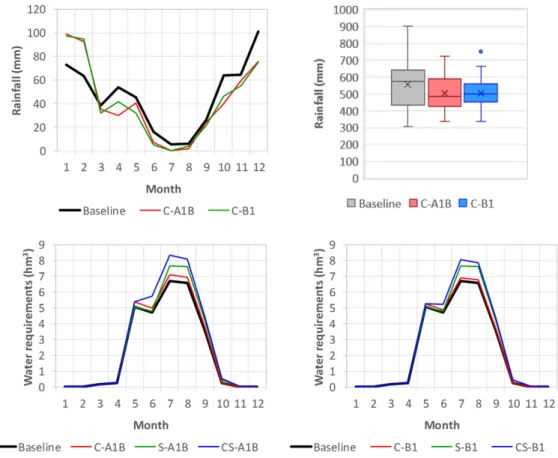
Climate scenarios were taken from the work ofSerpa et al. (2015), who: (i) applied a predictor transformation approach to generate future seasonal rainfall scenarios from mean sea level pressure estimates made by the ECHAM5 Global Circulation Model for 2071–2100; (ii) used the fragments method to downscale seasonal rainfall predictions to daily predictions, by determining future daily rainfall in a given month using historical data for a month with similar rainfall characteristics; and (iii) used the delta change method (Hay et al., 2000) to estimate daily temperatures for the A1B and B1 scenarios (+2.2 and +1.1 °C, re-spectively). These scenarios were made for the Évora/Cidade station (Fig. 1); in this work, they were extended to the other meteorological stations based on linear regression equations calculated from historical data. These scenarios were introduced directly in SWAT as climatic input data for the model; also, calculated changes to potential evapo-transpiration were used to simulate changes to current water demands. The two climate scenarios led to almost identical decreases in annual rainfall (−9.3%), reflecting lower rainfall in autumn and spring com-pensated by higher rainfall in winter (+ 29.9% in C-A1B and + 28.3% in C-B1). The differences between them were more apparent in inter-annual rainfall variability (Fig. 2), with especially extreme rainfall years decreasing in frequency. This is in agreement with the results of the ENSEMBLES project for this region (van der Linden and Mitchell, 2009) and does not contradict the more recent results for scenario RCP8.5, where Mediterranean regions are an exception to the global trend of increasing wet extremes frequency (Collins et al., 2013). How-ever, the decrease in variability could also result from the selected downscaling method, an issue which is further explored in the discus-sion. The two scenarios also differed markedly in potential evapotrans-piration (PET), which increased more in C-A1B (+ 5.7%) than C-B1 (+3.5%) due to the higher temperatures.
Socio-economic changes consisted of three sub-scenarios focusing on changes to irrigation water demand, land use, and population.
For irrigation, the same scenario was used in both socio-economic storylines, involving the foreseen increase of the irrigated area with 944 ha of olive trees described above. This additional demand was as-sumed to be covered by the Vale do Gaio reservoir, as the above-men-tioned supplies from the Alqueva Multi-Purpose Infrastructure are not guaranteed. A specific SWAT application for this new irrigated area was made using present-day and future climate conditions, to estimate impacts on reservoir water demands. This scenario led to an increase of irrigation water demand between July and September (see A1B and S-B1Fig. 2). These increases, however, were much smaller than the in-crease in irrigated area (+11% vs. + 49%), as olive groves have lesser water requirements than currently existing ricefields. However, both climate scenarios also led to increased irrigation demands between May and August (Fig. 2), due to higher PET and lower rainfall, and these increases were higher in C-A1B (+5.9%) than in C-B1 (+3.4%), reflecting different PETs. In consequence, the combined
climate-socio-economic scenarios (CS-A1B and CS-B1) had higher irrigation demands than the separate scenarios, and the increases relative to baseline condi-tions indicated a non-linear effect, which was strongest in storyline A1B, due to the added impact of climate on the new irrigation areas.
Land-use changes followed the scenarios developed bySerpa et al. (2015)for the Guadalupe experimental basin, who downscaled and re-fined the national level land-use change predictions byJacinto et al. (2013)based on an analysis of local historical trends. In this study, the scenarios were expanded to the entire watershed, but modified so that the actual amount of land-use change matched the national-level predictions. They involved decreases in the cover of rainfed croplands and pastures (−73.4 and −54.3% in A1B and B1), as opposed to in-creases in the cover of forest (+ 19.6 and + 14.7% in A1B and B1), olive groves (+46% in both scenarios) and croplands for biofuel produc-tion (sunflower;Jacinto et al., 2013; Serpa et al., 2015). The foreseen increase in woodland cover was mainly due to new eucalypt plantations replacing croplands in A1B, and shrub encroachment of abandoned agriculturalfields in B1. These scenarios were then introduced in SWAT using a semi-distributed approach, i.e. by modifying land-use dis-tribution inside the broad land-use classes used in SWAT as well as by replacing crops. More information is available in the supplementary material.
Population changes were taken directly from downscaled projec-tions byJacinto et al. (2013), which were then refined with foreseen mi-gration rates from rural areas to the city of Évora, based on recent trends. The population densities in the A1B and B1 scenarios were near-ly identical, however, pointing to a population decrease of−4.8%. The population scenarios were used to assess changes in wastewater dis-charge from the Évora treatment plant, forecasting a decrease of direct P discharge of−7.3% which was then directly introduced in SWAT.
3. Results and discussion 3.1. Model performance evaluation
Table 1lists the model evaluation parameters for the application of SWAT under baseline conditions, whileFig. 3compares SWAT simula-tion results with the measurements for the Vale do Gaio reservoir. Over-all, the bulk of the SWAT results were, in absolute terms,“satisfactory” or better following the threshold values set byMoriasi et al. (2007). SWAT results for hydrological variables were“good” or “very good”, ex-cept for reservoir outflow. The “unsatisfactory” outflow simulations in terms of RSR and NSE reflected inherent limitations of SWAT, as water extractions are defined according to total demands and cannot be ad-justed to, for example, meteorological conditions or reservoir storage. This resulted in the simulation of excessive extractions and lower reser-voir storage levels, especially in consecutive drought years (e.g. 1992 to 1996, or 2005 to 2010), as also indicated by the relative high PBIAS of storage volume (−16.2%). These errors then accumulated in a poor sim-ulation of the monthly patterns of excessive storage and, hence, out-flow. Annual outflow predictions, however, should still be reliable, as also suggested by the“very good” PBIAS (2.1%).
SWAT results for sedimentflows and mineral Phosphorus mass in the reservoir were worse than for hydrological variables but were gen-erally satisfactory. Calibration of sediment inflows at the Torrão do Alentejo station was“unsatisfactory”, except for the “very good” PBIAS (−1.2%). Further calibration of SWAT parameters was not possible due to the considerable uncertainty surrounding the estimated sedi-ment yields, which were derived from a sedisedi-ment rating curve tested only with streamflow values up to 1.6 m3
s−1, when monthly streamflow values often exceed 10 m3s−1(Fig. 3) and daily values
often exceed 50 m3s−1. However, the validation performance was
“sat-isfactory” for the more reliable sediment yields at the Flor da Rosa Sta-tion (based on continuous turbidity measurements), as also shown in
3.2. Impacts on water availability and use
Table 2summarizes the scenarios and results for the relevant model parameters, in absolute and relative values (and more information is added in the supplementary material). In all scenarios, evapotranspira-tion remained relatively constant (between 401 and 422 mm y−1;Table 2), remaining by far the most important water balance component. In the climate change and combined scenarios (C and CS), this led to a higher fraction of rainfall being retained for evapotranspiration, at the expense of other components; it increased from 75 to 76% of rainfall in the baseline and S scenarios, until 79 to 81% of rainfall in the C and CS scenarios. This is a characteristic response to climate change of dry Mediterranean catchments with similar land uses (Nunes et al., 2008; Nunes and Seixas, 2011; Serpa et al., 2015).
Furthermore, all climate change scenarios revealed greater impacts on baseflow than on surface runoff, enhancing streamflow irregularity;
while baseflow changed from −29 to −39%, surface runoff change be-tween−12 and −24%. This also seems to be a typical response for dry Mediterranean systems, especially when soils are shallow and have a low water retention capacity (Nunes et al., 2013, 2008). Worth noting is that the land-use change scenarios led to a slight increase in runoff, partic-ularly surface runoff (+10 to +12%), at the expense of evapotranspira-tion, baseflow and percolation to deep groundwater. This was due to the lower water use and higher surface runoff generation of the new land uses, especially when converting from pastures and to shrublands.
As for reservoir water balance (Table 2), inflow (including a small di-rect contribution from rainfall) suffered important changes, with large decreases due to climate change alone (−25 and −27% in C-A1B and C-B1) and small increases due to land-use change alone (+ 3 and + 7% in S-A1B and S-B1). In the combined scenarios, changes were slightly less important than those for climate alone, especially in storyline B1 (−23 and −19% in CS-A1B and CS-B1), indicating that
Fig. 2. Scenarios for monthly rainfall (upper left), inter-annual rainfall variability (upper right, with boxes representing the median,first and third quartile, whiskers representing maximum and minimum, crosses representing the average, and dots representing outliers), and monthly irrigation water requirements in the A1B (lower left) and B1 (lower right) storylines.
Table 1
Evaluation of SWAT performance for the hydro-meteorological stations of the Xarrama basin (seeFig. 1), with values in italic, underlined and bold + underlined indicating respectively “unsatisfactory”, “good” and “very good” model performance according toMoriasi et al. (2007); remaining values indicate“satisfactory” model performance.
Parameter (monthly values) Station Type Period PBIAS RSR NSE r2
Effective evapotranspirationa
Évora/Mitra Validation 2004–2012 2.5% 0.54 0.71 0.75
Soil water contenta
Évora/Mitra Validation 2004–2012 −11.0% 0.50 0.76 0.82
Streamflow Torrão do Alentejo Calibration 1980–2001 8.9% 0.45 0.80 0.86
Flor da Rosa Validation 2001–2012 −22.2% 0.50 0.76 0.86
Reservoir inflow Vale do Gaio Validation 1980–2012 4.5% 0.52 0.72 0.80
Reservoir storage volumea
Vale do Gaio Validation 1981–2012 −16.2% 0.55 0.77 0.79
Reservoir outflow Vale do Gaio Validation 1981–2012 2.1% 0.77 0.41 0.53
Water use (irrigation)a
Vale do Gaio Validation 1980–2012 5.0% 0.50 0.75 0.76
Sedimentflow Torrão do Alentejo Calibration 1980–2001 −1.2% 0.76 0.41 0.69
Flor da Rosa Validation 2001–2012 −15.4% 0.69 0.52 0.53
Mineral P in reservoir (mass) Vale do Gaio Validation 2000–2008 −26.8% 0.70 0.56 0.58
aModel performance criteria as for streamflow (
the increased runoff due to land-use change had a slight mitigating ef-fect on the impacts of lower rainfall.
However, the decreases in inflow were largely absorbed by a de-crease in excess discharge during wet years (−74 to −83% in C and CS scenarios), which also led to a drop in discharge for hydropower use (from 8 to 4% of total use). Reservoir losses due evaporation and percolation to deep groundwater only suffered a small decrease, which is explained due to a lower reservoir volume, and hence lower surface and inundated areas; evaporation rate per unit area increased with higher temperature. Changes to irrigation water use followed the increases in irrigation water demand, although at a lower rate, since the increase in demand could not be completely met (+1 to +14% in-crease in water use vs. +3 to +21% inin-crease in demand). Overall, the
decrease in future inflow was therefore counteracted by a more efficient retention of inflows by the reservoir during wet years. A similar trade-off was found for a Sardinian reservoir byMereu et al. (2016).
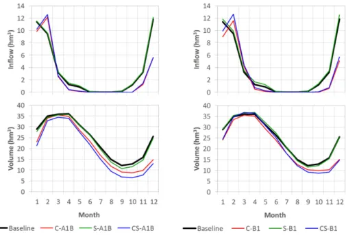
The timing of the reservoir inflow also suffered marked shifts in the climate change and combined scenarios (Fig. 4). The inflow during au-tumn and winter was delayed one month, reflecting the changes in the seasonal rainfall patterns (Fig. 2) This, combined with the general lower inflow and higher water use, led to a decrease in reservoir volume (values are shown inTable 2), which was most pronounced during the months with the lowest storage levels (August to November) and the months of storage recharge (December and January). In the worst-case scenario CS-A1B, reservoir volumes between September and No-vember were close to 50% of the present-day values.
Fig. 3. Rainfall (top) and comparison between monthly measured and simulated results for streamflow and sediment flow in the measuring stations shown inFig. 1, and for volume, irrigation water consumption and mineral Phosphorus mass in the Vale do Gaio reservoir, for 1980 to 2012.
Finally, future inflow also reflected the decrease in inter-annual rain-fall variability due to climate change (Fig. 2), with both overall ranges and interquartile ranges decreasing markedly (Fig. 5). This shows that changes in annual average values were mostly due to decreases in the number of wet years than in average years, as the median inflow only decreased in the CS scenarios. As a consequence, the number of years with hydropower production was almost halved in the climate change and combined scenarios, explaining the strong decrease in excess dis-charge and hydropower generation discussed above.
Furthermore, the increase in irrigation water consumption was followed by a decrease to the capacity of reservoirs to satisfy irrigation water demands in drier years (Fig. 5). While demand was met in more than half the years for all scenarios except CS-A1B, there was also an in-crease in inter-annual variability, with lower demand satisfaction rates during drier years; the 1st quartile satisfaction dropped from a baseline of 72%, to between 59 and 61% for the C and S scenarios, 55% for CS-B1, and 47% for CS-A1. In fact, while very low values could be considered outliers in the baseline scenario, this is not the case in others as they were in line with this higher variability. Scenario CS-A1B showed the least demand satisfaction: demand was not met in more than half of the years, and the 1st quartile was also noticeably lower than that of other scenarios.
However, the most relevant result for water availability was the in-crease in the number of years where demand satisfaction was below 85%, considered as a threshold for reasonable supply in irrigation (Martin-Carrasco and Garrote, 2007). Baseline conditions and scenario S-B1 showed 8 years of supply restrictions, while in other scenarios they were between 10 and 13, with the largest increase in scenario CS-A1B. These changes to demand satisfaction resulted mostly from lower storage volumes, due to lower average and wet season inflow in the C scenarios (Fig. 5), higher demand during normal years in the S sce-narios (Fig. 2), and a combination of both in the CS scenarios. As a result, less water was stored during drought years to satisfy demand. More in-formation can be found in the supplementary material.
3.3. Impacts on indices of water scarcity and exploitation
Fig. 6shows the impacts of all six future scenarios on the indices of water scarcity (focusing on the reservoir, and composed of two indices: demand satisfaction and demand reliability) and water exploitation (fo-cusing on the watershed). Most scenarios led to an important increase in water scarcity, mostly through a decrease in reliability rather than in satisfaction. The only exception was the socio-economic scenario S-B1, where the increase in inflow was enough to counteract the increase
Table 2
Annual climate variables and model results for the baseline conditions and the six future scenarios, in average annual totals and, in brackets, relative changes from baseline.
Parameter Baseline (1971–2000) Future scenarios (2071–2100)
C-A1B C-B1 S-A1B S-B1 CS-A1B CS-B1
Climate Rainfall 556.0 504.2 504.5 556.0 556.0 504.2 504.5
(mm y−1) (−9.3%) (−9.3%) – – (−9.3%) (−9.3%)
PETa
1117.9 1182.2 1156.9 1117.9 1117.9 1182.2 1156.9
(mm y−1) (5.7%) (3.5%) – – (5.7%) (3.5%)
Water balance EETb
421.6 404.7 407.6 422.4 415.0 406.0 400.9 (mm y−1) (−4.0%) (−3.3%) (0.2%) (−1.6%) (−3.7%) (−4.9%) Runoff 82.7 62.3 60.5 85.8 89.4 64.9 67.4 (mm y−1) (−24.7%) (−26.8%) (3.8%) (8.2%) (−21.5%) (−18.5%) - as surface runoff 53.7 42.9 41.1 59.3 59.9 47.4 46.7 (mm y−1) (−20.2%) (−23.5%) (10.4%) (11.5%) (−11.7%) (−13.1%) - as baseflow 28.9 19.4 19.4 26.5 29.5 17.5 20.7 (mm y−1) (−33.1%) (−32.9%) (−8.5%) (1.9%) (−39.6%) (−28.6%) Percolation to aquifer 51.7 37.3 36.4 47.7 51.6 33.3 36.3 (mm y−1) (−27.9%) (−29.6%) (−7.6%) (−0.2%) (−35.7%) (−29.8%)
Field exports Erosion 0.3 0.3 0.3 0.6 0.5 0.5 0.5
(ton ha−1y−1) (18.5%) (16.8%) (119.7%) (101.4%) (116.7%) (106.9%)
P exports 0.4 0.4 0.4 0.7 0.7 0.6 0.6
(kg ha−1y−1) (0.5%) (0.4%) (56.1%) (54.1%) (42.6%) (46.5%)
Reservoir water balance Volumec
24.6 20.9 21.4 23.8 24.8 19.2 21.7 (hm3 ) (−15.0%) (−12.7%) (−3.1%) (0.8%) (−21.8%) (−11.8%) Inflowd 43.6 32.6 31.7 45.0 46.8 33.7 35.1 (hm3y−1) (−25.3%) (−27.2%) (3.3%) (7.4%) (−22.6%) (−19.4%) Lossese 7.7 6.8 6.8 7.4 7.7 6.2 6.9 (hm3 ) (−12.1%) (−10.8%) (−3.1%) (0.7%) (−18.9%) (−9.8%) Outflow 11.8 2.9 3.0 11.8 12.7 2.6 3.6 (hm3 y−1) (−75.9%) (−74.5%) (−0.4%) (7.5%) (−77.7%) (−69.3%) - as hydropower discharge 3.4 1.4 1.3 3.2 3.7 1.2 1.5 (hm3y−1) (−58.3%) (−61.4%) (−5.7%) (9.4%) (−63.4%) (−56.7%) - as excess discharge 8.5 1.4 1.7 8.6 9.0 1.4 2.2 (hm3 y−1) (−82.9%) (−79.7%) (1.7%) (6.7%) (−83.4%) (−74.4%) Irrigation demand 27.3 28.9 28.2 30.3 30.3 33.0 31.7 (hm3 y−1) (5.9%) (3.4%) (11.2%) (11.2%) (21.0%) (16.2%) Irrigation use 22.1 23.5 22.4 23.7 24.3 25.1 25.1 (hm3 y−1) (6.1%) (1.4%) (7.3%) (9.9%) (13.5%) (13.5%)
Reservoir quality Sediment inflow 8.0 8.3 7.6 16.7 16.3 15.2 14.8
(103ton y−1) (4.3%) (−5.0%) (109.4%) (104.2%) (91.0%) (85.6%) P inflow 2.0 1.9 1.9 2.9 2.9 2.5 2.7 (ton y−1) (−4.8%) (−4.1%) (47.9%) (47.8%) (27.7%) (34.8%) P concentrationf 0.2 0.3 0.3 0.3 0.3 0.4 0.4 (mg L−1) (29.8%) (28.9%) (52.0%) (46.6%) (92.7%) (85.5%)
aPET: potential evapotranspiration. b
EET: effective evapotranspiration.
c
Average annual value.
d Includes streamflow and direct rainfall. e
Includes evaporation from the reservoir surface and percolation from the reservoir bed.
in demand, which led to almost no changes in both indices. Following the thresholds byIglesias et al. (2011), the Vale do Gaio reservoir pres-ently faces medium water scarcity conditions, and this will not change in the future, except in the case of the combined CS-A1B scenario for which serious water scarcity is predicted; in fact, while in other scenar-ios satisfaction decreases from 81 to 78% and reliability decreases from 73 to 63%, CS-A1B has a satisfaction index of 76% and a reliability index of 56%. This concurred with what was already visible in the inter-annual variability (Fig. 5), where CS-A1B is the only scenario where the median demand satisfaction is under 100%. In terms of the water exploitation index, present-day and future conditions corresponded to severe water stress. However, the climate change and combined scenarios resulted in a marked increase in the fraction of available water resources exploited for use (from a range between 51 and 53%, to between 71 and 74%); decreases in inflow had a larger im-pact than the increases in water demand.
The water scarcity and exploitation indices therefore demonstrated different aspects of future water resources. The scarcity index revealed a clear contrast between the two storylines, i.e.: (i) in the case of the A1B storyline, the socio-economic changes had as much impact as the climate changes, and these impacts were additive when socio-economic and climate changes were combined; in the case of the B1 storyline, the socio-economic changes hardly had any impact, as opposed to the
climate changes. The water exploitation index, on the other hand, re-vealed similar impacts for both storylines and these impacts were main-ly due to climate changes, markedmain-ly reducing inflow.
Since future changes to the water scarcity index were mostly due to a decrease in demand reliability (and, as such, mainly an issue of supply timing) rather than to a change in total supply, this problem could prob-ably be addressed by multi-year strategies of water supply manage-ment. On the other hand, the problems indicated by the exploitation index pointed to the need for measures addressing water supply. These implications for management are further explored below. 3.4. Impacts on reservoir siltation and trophic state
Fig. 7shows the average annual rates of erosion and phosphorus (P) export for each land-use type under baseline and future conditions. In the case of the present-day land-use types, any changes were, by de fini-tion, limited to the climate change and combined scenarios (C and CS); however, changes in erosion and P export revealed similar trends for the individual land-use types, reflecting the predominance of the organic and, thus, particulate fraction in total P exports. These trends differed between land-use types, with climate changes increasing erosion and P export rates in winter cereals (+ 45 to + 46% erosion and + 30 to + 35% P exports), while decreasing them in summer cereals (−13 to
Fig. 4. Monthly reservoir inflow (top) and volume (bottom) for the different scenarios of storylines A1B (left) and B1 (right).
Fig. 5. Annual reservoir inflow (left) and water demand satisfaction (right) for the different scenarios, with boxes representing the median, first and third quartile, whiskers representing maximum and minimum, crosses representing the average, and dots representing outliers (distance to either quartile greater than 1.5× the interquartile range). Note that, for water demand satisfaction, the maximum, third quartile and median coincide in all scenarios except CS-A1B.
−17% erosion and −22 to −25% P exports), olive groves (−20 to −31% erosion and −19 to −28% P exports) and forests. These different trends can be associated with different cover patterns (see the supple-mentary material for more information). Winter cereals have lower cover during the wet season, precisely when an increase in rainfall is predicted (seeFig. 2); future warmer winters are expected to accelerate vegetation growth and anticipate leaf emergence (by up to one month
in scenario A1B), but this is not enough to mitigate this impact. Perma-nent vegetation such as olive groves and forests, on the other hand, will maintain high cover during the wet season, even if the dryer climate might decrease this somewhat in eucalypts; therefore the lower rainfall leads to a decrease in already low erosion rates. These results concur with those of other studies in the same region and with similar scenar-ios (Nunes et al., 2013, 2008; Nunes and Seixas, 2011; Serpa et al., 2015).
Fig. 6. Water scarcity index (left) and water exploitation index (right) for baseline conditions and the six future scenarios; dashed lines represent thresholds as determined byIglesias et al. (2011)andAlcamo et al. (2003), respectively.
Fig. 7. Average annual rates of erosion (top) and phosphorus exports (mid) for each land-use type under baseline and future conditions, and of associated inflow rates of sediments (bottom left) and Phosphorus (bottom right) into the Vale do Gaio reservoir.
However, differences between land-use types largely defined the dif-ferences in erosion and P exports between the scenarios shown inTable 2. Therefore, changes in baseline erosion and P exports were more impor-tant in the S and CS scenarios than in the C scenarios due mostly to land-use changes (Fig. 7), as was also found bySerpa et al. (2015). Sedi-ment and P inflows to the reservoir revealed the same pattern of changes, but were attenuated by in-stream deposition/retention of eroded sedi-ments and P. Sediment and P inflow changed from −5 to +4% and −4 to−5% (respectively) in the C scenarios, but +86 to +109% and +28 to +48% (respectively) in the S and CS scenarios. The differences between the CS and S scenarios were due to the lower water inflows (seeTable 2). The predominant role of land-use change in projected sediment and P in-flows can easily be seen inFig. 7, since in the S and CS scenarios, the newly added sunflower culture was the dominant source of sediment and P inflows. Wastewater from the Évora treatment plant was also an impor-tant source of P inflows, but it changed little from baseline to projected conditions, independent of the scenarios.
The projected changes in sediment inflow rates had no noticeable consequence for reservoir siltation. The sediment inflows in present day conditions and under climate change scenarios (C) led to a loss of c. 0.01% reservoir volume per year, while those of the land-use change scenarios (S and CS) led to a loss of c. 0.02%; in both cases, reservoir life-time was measured in thousands of years. These minor impacts not only reflect the relatively low erosion rates, which are in line with typical ob-servations in Mediterranean regions (Cerdan et al., 2010), but also the large volume of Vale do Gaio. To illustrate the importance of a large vol-ume, the reservoir of São Brissos (with a volume that is c. 1% of that of the Vale do Gaio) is foreseen to lose 0.7% of its storage volume per year under baseline conditions but increasing to 1.4% per year in the CS scenarios. The land-use change scenarios (S and CS) did nonetheless have consequences for land degradation, as erosion rates in sunflower fields was close to the tolerable rate of 1 ton ha−1y−1(Verheijen et
al., 2012), much higher than the rates in the landcovers they replaced (0.1 to 0.2 ton ha−1y−1in pastures and 0.4 to 0.6 ton ha−1y−1in win-ter cereals). Thisfinding is corroborated by the results ofSerpa et al. (2015). Finally, changes to inter-annual distribution followed those of rainfall and streamflow, but also changed in proportion to changes in erosion rates; variability decreased in the climate change scenarios and increased in both the landuse change and the combined scenarios, although to a smaller degree in the latter (more information in the sup-plemental material).
The increases in P inflow in the S scenarios (+48% in both storylines) produced analogous increases in P concentration within the reservoir (+52 and +47% in S-A1B and S-B1). In contrast, the in-creases in P concentration in the climate change scenarios (+ 30 and +29% in C-A1B and C-B1, +93 and +86% in CS-A1B and CS-B1) were much larger than could be expected from changes in inflow alone (−5 and −4% in C-A1B and C-B1, +28 and +35% in A1B and CS-B1), and were to a large extent caused by lower reservoir volumes (Table 2). These increases were especially larger in the winter months, when higher P inflows were combined with lower water storage. They were also much higher in years of exceptionally low water storage, with average annual concentrations occasionally reaching values well above 1 mg L−1in all scenarios, despite the typical annual concentration range between 0.3 and 0.4 mg L−1(Table 2); see the supplementary material for more information. Even under baseline conditions, howev-er, P concentrations were well above the WFD threshold of 0.07 mg L−1. While results did not allow the simulation of future rations between ni-trogen and phosphorus, this increase in P loads would counteract the existing P limitation in spring, and possibly lead to even larger algal growth and the worsening of an already-high trophic state.
3.5. Overall comparison with other studies
In general terms, the predicted impacts of the scenarios presented here for the Xarrama watershed concur with those for the
Mediterranean in general and this region in specific (Molina-Navarro et al., 2014; Mourato et al., 2015; Nunes et al., 2013, 2008; Serpa et al., 2015; Simonneaux et al., 2015): decrease and greater seasonal contrast in streamflow, and increase in soil losses mostly due to land-use evolu-tion associated with climate change. It is interesting, however, to com-pare watershed-scale and reservoir-scale impact assessments. For example,Serpa et al. (2015)found that socio-economic scenarios usual-ly had small impacts on water resources at the watershed scale when compared with climate scenarios, while this study found that they had large impacts on water resources due to increased irrigation water de-mand. The same authors also found that land-use change scenarios caused important erosion problems at the watershed scale, while this study found that such enhanced erosion rates only had small conse-quences for reservoir siltation due to the relatively large volume of the Vale do Gaio reservoir.
This highlights that the predicted impacts of climate change at the watershed scale, while consistent across multiple studies for this region, cannot be taken by themselves as reliable indicators of impacts on water supply systems. This work confirms earlier studies that the characteris-tics of the water supply system should play a crucial role in global change impact and vulnerability assessments. Such characteristics in-clude water demand (Mereu et al., 2016; Stigter et al., 2014), reservoir volume and drained area (López-Moreno et al., 2014; Mereu et al., 2016) and water management policies (Garrote et al., 2016; Iglesias et al., 2011).
While climate change scenarios are relatively consistent across im-pact assessments, socio-economic scenarios definitely are not, even for the same storyline, as they depend both on the specific edaphoclimatic context as well as on volatile societal changes (Stigter et al., 2015). This has led to the creation of different hypothetical scenarios, which can be considered equally valid when based on past trends, planned changes, and consistent future storylines. For example,López-Moreno et al. (2014)propose an alternative land-use scenario that foresees agricul-tural abandonment which then results in a decrease water of demand and supply, whileMolina-Navarro et al. (2014)present a range of differ-ent land-use scenarios that have contrasting consequences for reservoir trophic state, mainly depending on agricultural abandonment or inten-sification. The lack of important impacts of land-use changes on water supply reported here can be attributed to a combination of shallow soils and impervious bedrock preventing tree roots development. A similar explanation was suggested byCarvalho-Santos et al. (2016)
andHawtree et al. (2015)for watersheds in northern and central Portu-gal, respectively. Due to these uncertainties surrounding socio-econom-ic and land-use change scenarios, and their potentially high relevance, it is still difficult to generalize reservoir-scale impacts of global change for the Mediterranean.
Twofindings of this study, however, seem to have much potential to be generalized, especially since they are consistent with those obtained for other supply systems in very different conditions. Thefirst is that a decrease in water supply leads to changes in supply reliability rather than in total demand satisfaction, which translates as an increase in the frequency of agricultural droughts. Similar results were obtained for the water supply systems in the Ebro watershed (Martin-Carrasco and Garrote, 2007) and for aquifer-supplied systems in Spain, Portugal and Morocco (Stigter et al., 2014). The second is that most of the im-pacts are absorbed by losses to excess discharges and hydropower pro-duction, as a lower storage volume resulting from higher demands in dry years also allows capturing more water in wet years; this impact is also expected for reservoirs in Sardinia (Mereu et al., 2016) and Spain (Bangash et al., 2013).
3.6. Implications for water management
The results of this study point to a future increase in water scarcity and stress. However, in most scenarios, a moderate decrease in precip-itation (−10%) led to a moderate aggravation of present-day
management problems, rather than to the occurrence of new and more severe problems. In fact, most scenarios pointed to lower demand satis-faction and higher exploitation, but maintaining already-existing levels of water scarcity (medium) and of water exploitation (severe stress); only a particularly negative combination of changes to land use, water demand and climate in scenario CS-A1B led to a change in scarcity level from medium to serious (Fig. 6). The same is true for siltation and trophic status: none of the scenarios indicated siltation problems in Vale do Gaio but all led to a worsening of the already existing eutro-phication problems. Therefore, in the case of Vale do Gaio, water avail-ability seems to be resilient to climate change; adaptation measures should focus on addressing already existing problems. In particular, the existing eutrophication problem also needs to be solved due to the implementation of the WFD, potentially allowing important synergies in designing and implementing future management measures.
These results also indicate that some of the conditions proposed in the socio-economic scenarios might not be sustainable in 2071–2100. In terms of water supply, the additional irrigation water demand might lead to serious water scarcity in climate scenario A1B (Fig. 6). As for water quality, both the additional water demand and the replace-ment of pasture by sunflower might be unsustainable, as they combine to increase P concentration by respectively lowering water volumes (Fig. 4) and increasing P inflows (Fig. 7). This would complicate achiev-ing the aims of the WFD for P concentrations, which as stated above are already above the threshold for good water quality status.
This study also points to distinct impacts of climate as opposed to socio-economic changes. Although both do increase water demand, cli-mate change decreasesfirst and foremost the amount of water supply, while socio-economic change decreases its quality. This indicates that potential adaptation options should address land-use management at the watershed scale, as it could attenuate potential water quality issues and, at the same time, decrease water demand. For example, water de-mand could be decreased by changing the irrigated crop mix, as was il-lustrated by the present results of lower water consumption by olive trees when compared to rice; and water quality could be improved by lowering P exports through a managed abandonment of pastures and re-wilding with forests or shrublands (Fig. 7).
Finally, adaptation measures have been linked to changes in the components of the water scarcity and exploitation indices by Martin-Carrasco and Garrote (2007). For most scenarios with medium scarcity, the authors point to solutions in managing demand and better regula-tion of multi-year supplies, which could be concretized with e.g. better drought forecast, better operation rules for scarcity conditions, or an in-crease of storage volume. For the CS-A1B scenario, with serious scarcity, solutions could also involve water transfers from the Alqueva reservoir (a major regional water source as detailed earlier); in fact, the same can be argued for the other scenarios (C and CS), because of the very high water exploitation index (Fig. 6). Of course, the implied additional pres-sure on the Alqueva reservoir would need to be carefully considered through a regional scale analysis, and additional options such as de-creasing irrigated areas might have to be considered.
3.7. Uncertainties and future work
This study illustrated the potential impacts of two climate and land-use change scenarios and their combinations on a single water supply reservoir in a dry Mediterranean region. Climate change impact assess-ment studies are normally hindered by uncertainties in the scenarios and the model itself, which can propagate uncertainty to thefinal results.
Afirst source of uncertainty is in the future emission of greenhouse gases and the climate sensitivity to these emissions (Collins et al., 2013; Stigter et al., 2014), This work used two emission scenarios but only one Global Circulation Model (GCM). However, it is difficult to di-rectly compare these scenarios with GCM predictions for this region, since the range of rainfall predictions for 2071–2100 in this region is
particularly large: between +28% and−50%, with more variability at-tributable to differences between GCMs than to differences between scenarios (Miranda et al., 2006). This could be due to the location of the Iberian peninsula in the border between regions of increasing and decreasing rainfall scenarios (Collins et al., 2013), where GCM resolu-tion could be too coarse to assess local changes.
It is therefore more accurate to compare the scenarios selected for this work with those derived using Regional Climate Models (RCMs) with higher resolution. The forecasts for scenario A1B represented a rel-atively small decrease when compared with the range of RCM predic-tions (between−8 and −27%) from project ENSEMBLES for this region (van der Linden and Mitchell, 2009), although half of the GCM forecasts were in a similar range to those from this work; the supple-mentary material has more information. The seasonal distribution roughly agreed with that of the ENSEMBLES models, although with a relatively later wet-season rainfall increase.
RCM projections also exist for scenarios A2 and B2 from project PRU-DENCE (Christensen and Christensen, 2007) and for the more recent scenarios RCP4.5 and RCP8.5 from project EURO-CORDEX (Jacob et al., 2014). The more severe scenarios A2 and RCP8.5 have similar ranges of change to A1B (respectively,−15 to −35% and −11 to −30%), this despite RCP8.5 representing a more severe emission scenario; pos-sibly this results from the improved performance of RCMs used in EURO-CORDEX when compared with earlier models (Kotlarski et al., 2014). Both PRUDENCE and EURO-CORDEX results also show winter rainfall increases. This indicates that the A1B scenario used in this work is also comparable to forecasts for RCP8.5, although close to the lower end, and lower than forecasts for A2. As for the less severe climate change scenarios, there are no RCM forecasts for the study area for sce-nario B1, but the B1 scesce-nario used in this work is well within the range of both scenarios B2 (0 to−15%) and RCP4.5 (+2 to −19%). Overall, the selected rainfall scenarios might underestimate the severity of rain-fall changes, although they are still included the range of the newer RCP forecasts.
Another source of uncertainty is the downscaling of global climate projections to local conditions (Ehret et al., 2012; Maraun et al., 2010; Mourato et al., 2014). Statistical downscaling approaches can misrepre-sent future climate due to physical inconsistencies between tempera-ture and rainfall values, difficulties in representing the daily structure of rainfall, or the underestimation of interannual variability (Maraun et al., 2010; Stigter et al., 2014). However, dynamic downscaling methods based on RCMs usually require some sort of bias correction which can also lead to physical inconsistencies and misrepresentation of daily patterns (Ehret et al., 2012; Flato et al., 2013; Maraun et al., 2010). This work tried to circumvent limitations in statistical downscal-ing by usdownscal-ing only one climate predictor (sea level pressure) and past daily data to generate future series (Serpa et al., 2015), but this method could have led to lower inter-annual variability, especially in scenario B1 (Fig. 2); however, it should be noted that inter-annual variability in this work for scenario A1B was in line with that of the ENSEMBLES RCMs.
The simulation of hydrological response to climate change can also lead to uncertainties (Lespinas et al., 2014; Sellami et al., 2013).This issue was discussed in depth for this region bySerpa et al. (2015), which indicated that model uncertainty was decreased by the multi-ob-jective calibration with several hydrological variables, and especially by the calibration with a long time series including extreme wet and dry years (Fig. 3). However, the use of average export rates to calibrate sed-iment, nitrogen and phosphorus exports increases the uncertainty for these results, as the model might not be accurate for the full range of crops, especially when considering that the model could not be calibred to vegetation growth cycles adaptcalibred to higher temperatures and at-mospheric CO2concentrations (Nunes et al., 2008; Nunes and Seixas,
2011).
Finally, the selection of socio-economic scenarios can also induce important uncertainties (Molina-Navarro et al., 2014; Stigter et al.,