ISSN: 1809-4430 (on-line) www.engenhariaagricola.org.br
2 Universidade Estadual do Oeste do Paraná/ Cascavel - PR, Brasil. 3 Universidade Estadual do Oeste do Paraná/ Francisco Beltrão - PR, Brasil. Received in: 10-23-2017
Accepted in: 1-31-2018
Doi:http://dx.doi.org/10.1590/1809-4430-Eng.Agric.v38n2p 277-283/2018
IMPLICATIONS FOR PEAK FLOWS OF THE MARRECAS RIVER BASIN DUE TO
CHANGES IN THE BRAZILIAN FOREST CODE
Wagner de Aguiar
1*, Silvio C. Sampaio
2, Julio C. Paisani
3, Ralpho R. dos Reis
21*Corresponding author. Universidade Tecnológica Federal do Paraná/ Francisco Beltrão - PR, Brasil. E-mail:
KEYWORDS
surface runoff,
forestry legislation,
hydrological
simulation, land use.
ABSTRACT
Changes in the Brazilian Forest Code (BFC) have soften the criteria for recovery and
conservation of permanent preservation areas (PPAs), enhancing processes related to
surface runoff. The aim of this study is to understand the effects of changes in PPA
classification criteria established by BFC of 2012 to the detriment of BFC from 1965
considering the surface runoff response in the basin draining the upper Marrecas River
valley in the flow peaks. The HEC
–
HMS model was used to simulate flow peaks
considering three land-use scenarios, representative of the current use, adapting it to PPAs
fitted to the BFC of 1965 and 2012 and seven precipitation return periods. In the proposed
scenarios, the use of BFC of 2012, to the detriment of that from 1965, would imply a PPA
reduction from 44.5% to 13.7%, resulting in a 22.1% increase in the average flow peaks,
not representing, however, a significant reduction in the flow peaks when compared to the
scenario representing the current land use. Therefore, when compared to BFC of 1965, in
the Brazilian new Forest Code PPAs were reduced by 69.2%, increasing peak flows by up
to 30.7%, thus minimizing the legal possibilities of flood mitigation to the urban perimeter
of Francisco Beltrão, Paraná State, Brazil.
INTRODUCTION
Brazilian Forest Code (Law no. 4,771 of 1965) was in force regulating the activities of land use and occupation considering the 1960s socioeconomic context. However, the Brazilian new Forest Code (Law no. 12,651 of 2012) updated the legislation to the current context and changed several aspects, including the classification criteria of permanent preservation areas (PPAs), significantly reducing the potential area to be recovered by native vegetation (Soares-Filho et al., 2014). These changes in land use and occupation affect water cycle and its availability, wh ich may accentuate the occurrence of natural disasters and environmental damages (Coutinho et al., 2013, Lin et al., 2014; Reis et al., 2015).
The basin drained by the upper Marrecas River valley is occupied by more than 65% of agricu ltural areas, characterizing a form o f family farm production (Savoldi & Cunha, 2010). Th is occupation model caused profound changes in the landscape with the replacement of the Araucaria mo ist forest by agricultural activities (Cassol & Morais, 2014). These changes may have intensified the recurrent floods affecting the urban perimeter of Francisco Beltrão, Paraná State, Brazil, due to the removal of forest
cover, which presents a greater capacity to infiltrate precipitated water when co mpared to other land uses (Costa et al., 2012; Kibena et al., 2014; Lotz et al., 2017).
According to historical flow and Civil Defense data, fro m 2010 to 2017 seven flood events were recorded mainly due to the drowning of Marrecas River tributaries crossing the urban perimeter of Francisco Beltrão. The highest flood quota was registered in May 2014, displacing 1050 people due to a daily precipitation of 195 mm (Andres et al., 2015). The Marrecas River basin has been effectively occupied since 1950, and the main changes in its landscape occurred due to the replacement of natural forest by agricultural and pasture uses in the first three decades and urban occupation in the next years (Machado, 2009).
2017), land use (Githui et al., 2009; Sanyal et al., 2014; Lotz et al., 2017; Mayerhofer et al., 2017), and vegetal cover (Marques et al., 2007; Mu et al., 2015; Zhang et al., 2015; Silva et al., 2016b; Yu et al., 2016) on the balance of continental waters.
Although several authors have studied hydrological simu lations of land use scenarios (Ali et al., 2011; Du et al., 2012; Sanyal et al., 2014; Lin et al., 2014; Silva et al., 2016b), some with a practical nature in the management of water resources (Razi et al., 2010; Du et al., 2012; Pereira et al., 2014; Pontes et al., 2016; Kurtz et al., 2017), few have sought to understand the impacts of deforestation (Wan & Yang, 2007; Kalantari et al., 2014; Algeet-Abarquero et al., 2015) and fewer are those that investigated the implications of peak flows resulting fro m changes in the limits of PPAs established by the Brazilian Forest Code (BFC) of 2012.
In this context, this study aimed to
understand the effects of changes in PPA classification criteria established by BFC of 2012 to the detriment of BFC fro m 1965 considering the surface runoff response in the basin draining the upper Marrecas River valley in the simu lated flo w peaks, allowing understanding the effects of changes in BFC on the flood mitigation process of the urban perimeter of Francisco Beltrão, Paraná State, Brazil.
MATERIAL AND MET HODS
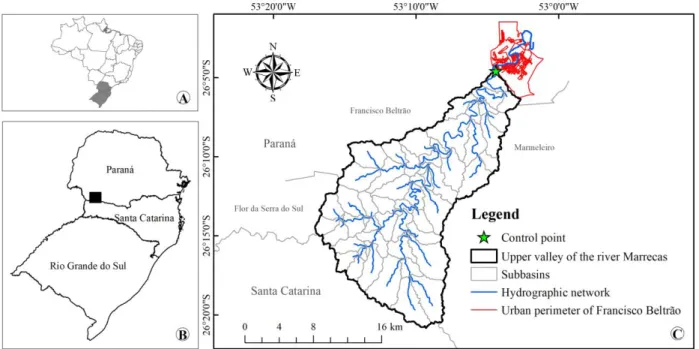
This study was carried out in the Marrecas River basin upstream of the urban perimeter of Francisco Beltrão, PR, Brazil, at the control point with geographical coordinates 26°04′53″ S and 53°04′30″ W. The basin has an average altitude of 736 m and covers three municipalities in the Paraná State (Marmeleiro, Flo r da Serra do Sul, and Francisco Beltrão) (Figure 1).
FIGURE 1. Spatial d istribution of southern Brazil (A), Marrecas River basin in the Paraná State (B), and basin draining the upper Marrecas River valley, subdivided into 59 sub-basins as the drainage network considered in this study (C).
The control point in the Marrecas River was chosen for having a fluvio metric station (code 65950200/Instituto Águas Paraná), being a point of water collection by the Sanitation Co mpany of Paraná (SANEPAR) for public supplying of a large part of Francisco Beltrão, and representing the point of entry of the river in the urban area, highly affected by floods.
Hydrological simu lations considered the peak flow parameter, wh ich is the surface runoff response in the drainage channel, whose overflow to its banks determines the mo ment of maximu m occupation by the flood. Simu lations were performed by the HEC–HMS 4.1 (Hydrologic Engineering Center–Hydrologic Modeling System) model, wh ich required a model input with the physical characteristics of the basin and channels, precipitation data, and control specifications with intervals of simulations.
Basin and channel characteristics were obtained by using the extension HEC–GeoHMS (Geospatial Hydrologic Modeling Extension), run by the software
ArcMap 10.1. This extension requires the input of a digital elevation model (DEM) and information of the drainage channels, providing data on surface runoff and flood wave propagation in the channels.
The DEM, with a spatial resolution of 30 m, was preprocessed by delineating the basin draining the upper Marrecas River valley upstream of the urban perimeter of Francisco Beltrão, with an area of 337.9 km2. The basin was subdivided into 59 sub-basins in order to improve the spatial representation of the hydrological processes, composed of a hydrographical line generated fro m the minimu m drainage area of 1% of the total area, whose distribution is shown in Figure 1.
method).
Land use was classified by the software Spring with an image of the satellite CBERS 4, PAN sensor from April 2, 2016, generated by the National Institute for Space Research (INPE), rando mly chosen. Segmented with a similarity level of 10 and a minimu m area of 25 pixels, the uses were individualized by the Bhattacharya classifier at a 95% acceptance threshold. Use composition took into account the classification key shape, color, and texture possible to be identified in the images.
Three scenarios of land use were generated: reference use (RS), representative of the current use, with an image of April 2, 2016; RS with PPAs adapted to Articles 4 and 61-A of the Brazilian Forest Code of 2012 (BFC2012); and RS with PPAs adapted to Article 2 of the Brazilian Forest Code of 1965 (BFC1965).
The adequacy of PPAs to BFC2012 needed information of average sizes of rural properties, which were co llected in the field fro m rando m samplings of five properties for each of the 59 sub-basins. It also required the classification of land uses in PPAs defined by the Article 4 prio r to July 22, 2008, to define the “consolidated areas in permanent preservation areas” established by the Article 61-A.
The three land use scenarios were reclassified into a magnitude of CN (curve nu mber), as reco mmended by the Soil Conservation Service of the US Department of Agriculture (USDA–SCS) and generated by HEC–
GeoHMS. For this, land use scenarios were confronted with hydrological g roups of soils of the basin under AMC (antecedent mo isture condition) II (USDA, 1986).
For flow peak simu lations, according to the requirements established by BFC1965 and BFC2012, PPAs were considered as occupied by native vegetation in the upper Marrecas River valley region (Araucaria mo ist forest), adopting CN values of forest cover (Roderjan et al., 2002).
The individual analysis of PPAs (riverbanks, surroundings of springs, hilltops, among others) did not take into account the overlapping of the same areas generated by different PPA classes. Therefore, the sum of individualized PPAs exceeded the values of total PPAs adequate to each of BFC.
Flood wave propagation calculated by
the Muskingum-Cunge method required information of width, lateral slope, and Manning roughness (n) of the drainage channels. These data were collected in the field by sampling three points for each channel of the 59 sub-basins, totaling 177 sampled points.
Precip itations were generated by intensity-duration-frequency curves (IDF), as proposed by Fendrich (2011) for Francisco Beltrão, Paraná State, Brazil, for return periods of 2, 5, 10, 25, 50, 100, and 200 years. The duration of each precipitation corresponded to the concentration-time of the basin delimited by the upper Marrecas River valley, calculated by the formula US Corps of Engineers (Silveira, 2005), and distributed by the alternating blocks method with 15-min intervals.
Simu lation control specifications were determined in order to obtain all the details of basin responses on the flow distribution. For this, between the beginning and the end of the process, the simulations of each treatment totaled 30 h.
The results consisted of a randomized b lock design with three treatments representative of the land occupation scenarios. In order to understand variations in flow peaks (response variable) in the land use scenarios under different precipitation probability conditions, treatments were analy zed in seven blocks/replications formed by return periods of 2, 5, 10, 25, 50, 100, and 200 years. The results were analyzed by analysis of variance (ANOVA) at 5% significance. Rejected the null hypothesis (Ho), the
mu ltip le verifications of means of flow peaks generated in each treatment, two by two, were carried out by the Tukey’s test at 5% significance by using the software R.
RES ULTS AND DISCUSS ION
The adequacy of PPAs in the basin draining the upper Marrecas River valley to the Brazilian Forest Codes of 1965 and 2012 revealed wide d ifferences in territorial occupation. In BFC1965, PPAs comprised 44.5% of the total basin area (150.4 km2) whereas, in BFC2012, PPA areas occupied 13.7% (46.3 km2). The spatial distribution of land uses and occupations in the basin draining the upper Marrecas River valley, adequate to the proposed scenarios, is shown in Figure 2.
Significant reductions in PPAs in complying with BFC2012 are due to the use of risk areas previously prohibited for use in BFC1965. This legislation change is attributed to an intense political interference with the rural sector, which was intended to be amnestied of infractions provided by BFC1965, in addition to increasing the exploitation area (Maccarini & Silva, 2016) for agriculture and livestock.
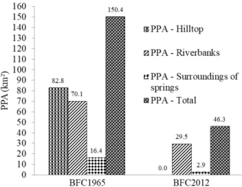
In the individualized verifications of PPA classes identified in the basin draining the upper Marrecas River valley, the greatest discrepancy occurred in the hilltop PPAs. In BFC1965, 82.8 km2 were classified as hilltop PPAs whereas no area had the same classification in BFC2012, as shown in Figure 3, which presents the variations of the other PPA classes. Changes in classification criteria of these PPAs reduced the potential area to be protected in hilltops, mounts, mountains, and sierras by 87% (Soares-Filho et al., 2014).
FIGURE 3. Co mparative values of PPAs from scenarios adapted to the Brazilian Forest Codes of 1965 (BFC1965) and 2012 (BFC2012).
These changes established by BFC2012 in the classification criteria of h illtop PPAs allo w their anthropic use, drastically affecting the hydrodynamic behavior and geological stability of dispersion slopes, which may accentuate floods and landslides in periods with high
precipitation volu mes (Coutinho et al., 2013).
Riverbank PPAs decreased from 70.1 to 29.5 km2 whereas PPAs responsible for the maintenance of surroundings of springs reduced from 16.4 to 2.9 km2
when comparing BFC1965 and BFC2012, respectively (Figure 3). The reduction in riverbank PPAs due to the authorization of anthropic use introduced by the Article 61-A of BFC2012 is considered one of the main step backward of the new legislation (Brancalion et al., 2016). However, th is reduction may be even greater according to a proposed amendment to the current forest code, currently in process in the National Congress (Reis et al., 2015). Changes in PPA classification criteria described in the transitional provisions of BFC2012 reduce the potential area to be recovered with native vegetation in Brazil by 58% in relation to BFC1965 (Soares-Filho et al., 2014).
Changes in BFC did not take into account the function of native vegetation and arrangement in the surface with a greater permeability to intercept and delay the surface runoff (Kibena et al., 2014; Lotz et al., 2017; Mayerhofer et al., 2017). BFC2012 affects the basin draining the upper Marrecas River valley, main ly under the terms of item IX of the Article 4, wh ich deals with the classification rules of hilltop PPAs, and under the terms of the Article 61-A, wh ich authorizes, in PPAs, “to continue agrosilvopastoral, ecotourism, and rural tourism activities in rural areas consolidated until July 22, 2008”. The anthropic use of these PPAs potentiates and increases flow peaks, increasing the frequency and severity of flooding (Costa et al., 2012; Kalantari et al., 2014; Sanyal et al., 2014; Algeet-Abarquero et al., 2015).
Considering the changes in PPA classification criteria due to BFC2012 validity, the statistical analyses confirmed the supposed impacts of reducing the native vegetation in the basin draining the upper Marrecas River valley on the flow distribution, as shown in Table 1. The null hypothesis (Ho) in the ANOVA was rejected,
indicating that changes in land use promoted changes in flow peaks.
TABLE 1. Flow peaks generated for reference scenarios and PPAs adapted to the Brazilian Fo rest Codes of 2012 and 1965.
Treatment (scenarios of land use Tukey 5%)
Peak flo w (m3 s−1) Precip itation return period (year)
2 5 10 25 50 100 200
Reference a* 507.3 728.3 937.4 1295.3 1639.7 2052.0 2543.5 PPAs – BFC2012a 473.8 681.4 891.8 1239.6 1576.3 1980.0 2460.8 PPAs – BFC1965b 362.6 540.5 715.4 1023.8 1318.5 1690.2 2132.9
*Equal letters represent statistical equality between flow peaks generated by land use scenarios, two by two, by the Tukey’s test at 5% significance.
The multip le analyzes of means of flow rates by the
Tukey’s test at 5% significance level revealed significant
differences between flow peaks generated by BFC1965 and those produced by BFC2012 and RS. However, no significant differences were observed between flow peaks generated by BFC2012 and RS.
Statistical interpretations confirm the influence exerted by the vegetation cover on flow distribution. Flo w
BFC2012 and RS make us think that changes in BFC minimize the legal possibilities of flood mitigation in the urban perimeter of Francisco Beltrão.
Forest substitution in PPAs in the basin drain ing the upper Marrecas River valley by anthropic uses increases surface runoff and soil losses by reducing evapotranspiration, vegetation interception, protection caused by roots, among others (Githui et al., 2009; Zhang et al., 2015; Eu m et al., 2016; Silva et al., 2016b; Lotz et al., 2017). The current agricultural cultivation, which is the main substitute for forest cover, compacts soil horizons mainly due to agricu ltural machinery traffic , reducing infiltration rates and increasing soil bulk density (Ankeny et al., 1990, Abu-Hamdeh, 2003; Gó mez-Rodríguez et al., 2013, Feitosa et al., 2015; Silva et al., 2016a).
The average percentage increase in flow peaks generated by BFC2012, when compared to those produced by BFC1965, was 22.1%, and could reach 30.7% for the return period with higher frequency (2 years). Considering the registered occurrence of seven flood events in the urban perimeter of Francisco Beltrão in the last 7 years, this last percentage may better represent the increase in flow peaks for this period, which is due to the beginning of
validity of Brazil’s new Forest Code (2012), to the detriment of the Brazilian Forest Code of 1965.
CONCLUS IONS
Considering the Brazilian Forest Code of 2012, PPAs in the basin draining the upper Marrecas River valley would be reduced by 69.2% when co mpared to the Brazilian Forest Code of 1965. In this case, the largest losses would occur in hilltop areas, responsible for the retention of a large portion of surface runoff, the main factor responsible for flood events in the urban perimeter of Francisco Beltrão, Paraná State, Brazil.
The simulated flow peaks increased by up to 30.7% for the 2-year precipitation return period, indicating that the higher the precipitation frequencies are, the greater the differences between flow peaks generated by the scenarios of the Brazilian Forest Codes of 1965 and 2012.
ACKNOWLEDGEMENTS
To the UTFPR-FB (Federal Technological University of Paraná, Campus Francisco Beltrão), PGEA GRI (Graduate Program in Agricultural Engineering of UNIOESTE, Campus Cascavel), Araucária Foundation, CAPES (Coordination for the Improvement of Higher Education Personnel), 3rd Independent Firemen Subgroup of the Fire Department of Paraná, and Laboratory of Geoprocessing of UNIOESTE, Campus Francisco Beltrão.
REFERENCES
Abu-Hamdeh NH (2003) Co mpaction and subsoiling effects on corn growth and soil bulk density. Soil Science Society of A merica Journal 67(4):213-1219. DOI: http://dx.doi.org/10.2136/sssaj2003.1213
Algeet-Abarquero N, Marchamalo M, Bonatti J,
Fernández-Moya J, Moussa R (2015) Implications of land use change on runoff generation at the plot scale in the humid tropics of Costa Rica. Catena 135:263-270. DOI: http://dx.doi.org/10.1016/j.catena.2015.08.004
Ali M, Khan SJ, Aslam I, Khan Z (2011)
Simu lation of the impacts of land-use change on surface runoff of Lai Nullah Basin in Islamabad, Pakistan. Landscape and Urban Planning 102:271-279. DOI: http://dx.doi.org/10.1016/j.landurbplan.2011.05.006
Andres J, Caneparo SC, Hendges ER (2015) Riscos de Inundação na Cidade de Francisco Beltrão (PR) por meio de Co mbinação Linear Ponderada Difusa. In : Simpósio Brasileiro de Sensoriamento Remoto. João Pessoa. Anais...
Ankeny MD, Kaspar TC, Horton R (1990)
Characterization of tillage and traffic effects on unconfined infiltration measurements. Soil Science Society of
America Journal 54(3):837-840. DOI:
http://dx.doi.org/10.2136/sssaj1990.036159950054000300 37x
Brancalion PHS, Garcia LC, Loyola R, Rodrigues RR, Pillar VD, Lewinsohn TM (2016) Análise crítica da Lei de proteção da vegetação nativa (2012), que substituiu o antigo código florestal: atualizações e ações em curso. Natureza & Conservação 14:e1-e16. DOI:
http://dx.doi.org/10.1016/j.ncon.2016.03.004
Cassol HLG, Moraes EC (2014) Recorte municipal do sudeste e sudoeste paranaense: relação entre os fatores sociais e econômicos com o desflorestamento na Floresta Ombrófila Mista? Rev ista Espinhaço 3(1):43-61.
Costa J, Costa A, Poleto C (2012) Telhado verde: redução e retardo do escoamento superficial. Rev ista de estudos amb ientais (On line) 14(2esp):50-56.
Coutinho MP, Medeiros JD, Soriano É, Londe LR, Leal PJD, Saito SM (2013) O Código Florestal Atual (Lei Federal nº 12.651/2012) e suas implicações na prevenção de desastres naturais. Sustentabilidade em Debate 4(2):237-256.
Du J, Qian L, Ru i H, Zuo T, Zheng D, Xu Y, Xu C-Y (2012) Assessing the effects of urbanization on annual runoff and flood events using an integrated hydrological modeling system for Qinhuai River basin, China. Journal of Hydrology 464-465:127-139. DOI:
http://dx.doi.org/10.1016/j.jhydrol.2012.06.057
Eu m H-I, Dibike Y, Prowse T (2016) Co mparative evaluation of the effects of climate and land-cover changes on hydrologic responses of the MuskegRiver, A lberta, Canada. Journal of Hydro logy: Reg ional Studies 8:198-221. DOI: http://d x.doi.org/10.1016/j.ejrh.2016.10.003
Feitosa JR, Fernandes HC, Teixeira MM, Cecon PR (2015) Influência da pressão interna dos pneus e da velocidade de deslocamento nos parâmetros operacionais de um trator agríco la e nas propriedades físicas do solo. Engenharia Agrícola 35(1):117-127. DOI:
http://dx.doi.org/10.1590/1809-4430-Eng.Agric.v35n1p117-127/2015
Githui F, Mutua F, Bauwens W (2009) Estimating the impacts of land-cover change on runoff using the soil and water assessment tool (SWAT): case study of Nzoia catchment, Kenya. Hydrological Sciences Journal 54(5):899-908. DOI:
http://dx.doi.org/10.1623/hysj.54.5.899
Gó mez-Rodríguez K, Camacho-Tamayo JH, Vélez-Sánchez JE (2013) Changes in water availab ility in the soil due to tractor traffic. Engenharia Agríco la 33(6):1156-1164. DOI:
http://dx.doi.org/10.1590/S0100-69162013000600008
Kalantari Z, Lyon SW, Fo lkeson L, French HK, Stolte J, Jansson PE, Sassner M (2014) Quantifying the
hydrological impact of simulated changes in land use on peak discharge in a small catch ment. Science of the Total Environment 466-467:741-754. DOI:
http://dx.doi.org/10.1016/j.scitotenv.2013.07.047 Kibena J, Nhapi I, Gu mindoga W (2014) Assessing the relationship between water quality parameters and changes in landuse patterns in the Upper Manyame River,
Zimbabwe. Physics and Chemistry of the Earth 67-69:153-163. DOI: http://d x.doi.org/10.1016/j.pce.2013.09.017
Kurtz W, Lapin A, Schilling OS, Tang Q, Sch iller E, Braun T, Hunkeler D, Vereecken H, Sudicky E, Kropf P (2017) Integrating hydrological modelling, data
assimilation and cloud computing for real-time
management of water resources. Environmental Modelling & Software 93:418-435. DOI:
http://dx.doi.org/10.1016/j.envsoft.2017.03.011
Lin K, Lv F, Chen L, Singh VP, Zhang Q, Chen X (2014) Xinanjiang model co mb ined with Curve Nu mber to simu late the effect of land use change on environmental flow. Journal of Hydrology 519:3142-3152. DOI: http://dx.doi.org/10.1016/j.jhydrol.2014.10.049
Lotz T, Opp C, He X (2017) Factors of runoff generation in the Dongting Lake basin based on a SWAT model and implications of recent land cover change. Quaternary International 30:1-9. DOI:
http://dx.doi.org/10.1016/j.quaint.2017.03.057 Maccarini TB, Silva AA (2016) relação entre o código florestal brasileiro e os desastres naturais. Revista Ordem Pública 9(1):223-233.
Machado G (2009) Transformações na paisagem da bacia do rio Marrecas (SW/PR) e perspectivas de
desenvolvimento territorial. Tese, Universidade Estdual
Paulista “Julio de Mesquita Filho”, Faculdade de Ciência e
Tecnologia.
Marques MJ, Bienes R, Jiménez L, Pérez-Rodríguez R (2007) Effect of vegetal cover on runoff and soil erosion under light intensity events. Rainfall simulation over USLE plots. Science of the Total Environ ment 378:161-165. DOI:
http://dx.doi.org/10.1016/j.scitotenv.2007.01.043 Mayerhofer C, Meiß l G, Klebinder K, Kohl B, Markart G (2017) Co mparison of the results of a small-plot and a large-plot rainfall simu lator – Effects of land use and land cover on surface runoff in Alp ine catchments. Catena 156:184-196. DOI:
http://dx.doi.org/10.1016/j.catena.2017.04.009
Mu W, Yu F, Li C, Xie Y, Tian J, Liu J, Zhao N (2015) Effects of rainfall intensity and slope gradient on runoff and soil mo isture content on different growing stages of spring maize. Water 7(6):2990-3008. DOI: http://dx.doi.org/10.3390/w7062990
Niemi TJ, Warsta L, Taka M, Hickman B, Pu lkkinen S, Krebs G, Mo isseev DN, Koivusalo H, Kokkonen T (2017) Applicability of open rainfall data to event-scale urban rainfall-runoff modelling. Journal of Hydrology 547:143-155. DOI: http://d x.doi.org/10.1016/j.jhydrol.2017.01.056
Pereira DR, Martinez MA, Almeida AQ, Pruski FF, Silva DD, Zonta JH (2014) Hydrological simu lation using SWAT model in headwatger basin in Southeast Brazil. Engenharia Agrícola 34(4):789-799. DOI:
http://dx.doi.org/10.1590/S0100-69162014000400018
Pontes LM, Viola MR, Silva MLN, Bispo DFA, Curi N (2016) Hydrological modeling of tributaries of Cantareira sytem, southeast Brazil, with the SWAT model.
Engenharia Agrícola 36(6):1037-1049. DOI: http://dx.doi.org/10.1590/1809-4430-Eng.Agric.v36n6p1037-1049/2016
Razi MAM, Ariffin J, Tahir T, Arish AM (2010) Flood estimation studies using hydrologic modeling system (HEC-HMS) for Johor River, Malaysia. Journal of Applied Sciences 10:930-939. DOI:
http://dx.doi.org/10.3923/jas.2010.930.939
Reis LC, Reis TES, Saab OJGA, Reis AS, Batista BG (2015) Código Florestal Brasileiro : Impactos econômicos e sociais no municíp io de Bandeirantes -PR. Engenharia Agrícola 35(4):778-788. DOI:
http://dx.doi.org/10.1590/1809-4430-Eng.Agric.v35n4p778-788/2015
Roderjan CV, Galvão F, Kuniyoshi YS, Hatschbach GG (2002) As unidades fitogeográficas do estado do Paraná, Brasil. Ciência e A mbiente 24(1):75-42.
Sanyal J, Densmore AL, Carbonneau P (2014) Analysing the effect of land-use/cover changes at sub-catchment levels on downstream flood peaks: A semi-d istributed modelling approach with sparse data. Catena 118:28-40. DOI: http://dx.doi.org/10.1016/j.catena.2014.01.015
Savoldi A, Cunha LA (2010) Uma abordagem sobre a agricultura familiar, PRONAF e a modernização da agricultura no Sudoeste do Paraná na década de 1970. Revista Geografar 5(1):25-45.
Silva VPR, Silva MT, Souza EP (2016b) Influence of land use change on sediment yield : A case study of the sub-middle of the São Francisco river basin. Engenharia Agrícola 36(6):1005-1015. DOI:
http://dx.doi.org/10.1590/1809-4430-Eng.Agric.v36n6p1005-1015/2016
Silveira A LL (2005) Desempenho de fórmulas de tempo de concentração em bacias urbanas e rurais. Revista Brasileira de Recursos Hídricos 10(1):5-23. DOI: http://dx.doi.org/10.21168/rbrh.v10n1.p 5-29
Soares-Filho B, Rajão R, Macedo M, Carneiro A, Costa W, Coe M, Rodrigues H, Alencar A (2014) Cracking
Brazil’s Forest Code. Science 344(6182):363-364. DOI:
http://dx.doi.org/10.1126/science.1246663
Suriya S, Mudgal BV (2012) Impact of urbanization on flooding: The thirusoolam sub watershed – A case study. Journal of Hydrology 412-413:210-219. DOI:
http://dx.doi.org/10.1016/j.jhydrol.2011.05.008
USDA – Un ited States Departament of
Agriculture (1986) Natural Resources Conservation Service. Urban Hydrology for Small Watersheds. In: TR-55. 2 ed. Available in :
https://www.nrcs.usda.gov/Internet/FSE_DOCUMENTS/s telprdb1044171.pdf. Accessed: Aug 17, 2016.
Wan R, Yang G (2007) Influence of land use/cover change on storm runoff - a case study of Xitiao xi River Basin in upstream of Taihu Lake watershed. Chinese Geographical Science 17(4):349-356. DOI:
http://dx.doi.org/10.1007/s11769-007-0349-6
Yu Y, Loiskandl W, Kaul H-P, Himmelbauer M, Wei W, Chen L, Bodner G (2016) Estimation of runoff mitigation by morphologically d ifferent cover crop root systems . Journal of Hydrology 538:667-676. DOI:
http://dx.doi.org/10.1016/j.jhydrol.2016.04.060