Revista GEAMA
The Journal of environment
Environmental diagnosis of the Monument Natural Pedra do
Cachorro, Pernambuco, Brazil
Deivide Benicio Soares
(¹
)*, Elvis Bergue Mariz Moreira
(1),Ranyére Silva Nóbrega
(1),
Marilourdes Viera Guedes
(²
)and Eberson Pessoa Ribeiro
(3)(1) Department of Geography, Universidade Federal de Pernambuco, Recife, Brazil.
(2) Department of Biology, Rural Federal University of Pernambuco, Recife, Brazil.
(3) Federal Institute of Education, Science and Technology of Pernambuco, Vitória de Santo Antão, Pernambuco,
Brazil.
* E-mail: deividebenicio@yahoo.com.br
ABSTRACT
The Conservation Unit Monument Natural Pedra do Cachorro, located in
Pernambuco Agreste, helped to increase the representativeness of the Caatinga
legally protected in the state of Pernambuco, reconcile the preservation of biological
diversity and the use of natural resources with ecotourism and tourism adventure
already developed in the region with great potential for expansion. This protected
area was established by a state decree in 2014, but were not realized, until now,
environmental diagnostics to characterize the natural environment of this area,
nor was it prepared its management plan. The objective of this work is then
present the main environmental characteristics of the Monument Natural Pedra do
Cachorro, regarding the physical and biotic environment. It is expected also that
this text will serve as a basis for further technical studies to be conducted in this
Conservation Unit.
Keywords: Conservation Unit, Caatinga, semiarid.
INTRODUCTION
Despite being the only exclusively Brazilian biome whose biological heritage is not found anywhere else in the world besides the northeastern of Brazil, there is only little time is that the Caatinga has achieved the deserved
prominence. For many years some myths were created around its biological diversity, mainly related to its "homogeneity", the low number of species and endemism and also to the fact that it was considered somewhat changed biome, when considering the savanna biome and its
protection status, it is evident the insufficient government action in this area.
These myths were broken from studies and projects specifically developed for the Caatinga, when the Ministry of Environment, through the project Conservation and Sustainable Use of Brazilian Biodiversity – PROBIO prepared the document "Priority Actions Assessment for Biodiversity Conservation Caatinga" that, among its objectives, there is the identification of priority conservation areas, based on criteria of biological importance, ecosystem integrity and opportunities for biodiversity conservation actions as well as the search for alternatives for sustainable use of natural resources.
The creation of protected areas in the savanna ratified the commitment of the state government to advance the protection of its biomes, especially in areas considered to be of biological importance "high" and "very high" and therefore priority for biodiversity conservation of the Caatinga.
The Government of the State of Pernambuco, through the Department of Environment and Sustainability – SEMAS, created a Working Group – GT by Ordinance No. 129/2010, of 15.10.2010, composed of Federal Institutions, State and NGOs, such as the Mid State Environment Agency of Pernambuco (CPRH), the Brazilian Institute of Environment and Renewable Natural Resources (IBAMA), the Chico Mendes Institute for Biodiversity Conservation (ICMBio), the Ministry of
Environment of Brazil (MMA), the
Development Company of the São Francisco and Parnaíba (Codevasf) and the State
Committee Biosphere Reserve Caatinga
(CERBCAA) for selection of priority areas and
establishment of protected areas in the Caatinga of the State of Pernambuco .
This group, with the support of MMA, promoted and coordinated the First Workshop for selection of priority areas for the creation of conservation units in May 2011, which resulted in a list of 13 areas, based especially the methodology used by the Ministry of the environment in 2002, when the completion of the selection of priority areas for conservation in the biomes in Brazil; also built by the Department of Science Technology and Environment of the State of Pernambuco – SECTMA in 2002, used when preparing the Atlas of priority areas for conservation in the state.
And reinforced by the need for compliance with legal parameters established by the State System of Conservation Units - SEUC when given in Article 29, that the priority areas for the creation of conservation units must meet specific when they contain ecosystems
underrepresented as conservation areas;
contain ecosystems in imminent danger of extinction or degradation; harboring greater diversity of endangered species, which are considered as priorities by the Atlas of Biodiversity of Pernambuco, the map of priority areas for biodiversity conservation MMA or inserted in the mapping of Biosphere Reserves.
Moreover, they were inserted technical criteria to select the areas indicated by the institutions invited to the workshop, which were adequate to the areas and so it was possible to list the areas in score order and prioritize them by social and environmental criteria.
At the time of the workshop, held in May/2011, the Working Group was presented the area of Serra do Cachorro, the CERBCAA member and at the time of the survey who accompanied the team SEMAS to the indicated place was responsible for PRNP Stone dog, to know the area well and their specificities.
The display area was welcomed and, by State Law 40549/2014, was created a Conservation Unit Dog Monument Natural Stone. It was not prepared, however, to date, the Management Plan of this course, and there are no studies to characterize the area.
The objective of this work is therefore to present the main environmental characteristics of the Monument Natural Pedra do Cachorro, regarding the physical and biotic environment.
It is expected also that this text will serve as a basis for further technical studies to be conducted in this Conservation Unit.
MATERIALS AND METHODS
The Conservation Unit (UC) Natural Dog Monument Stone is located on the border of the Swamp municipalities of the Brejo da Madre de Deus, São Caetano and Tacaimbó in Mesoregion
Agreste of Pernambucano, State of
Pernambuco, Brazil (Figure 1).
The area where it was created the State Conservation Unit Pedra do Cachorro, is located on private property, lying about 6 km from the city center of São Caetano, with a land area of 17 square kilometers and comprises the Serra do Cachorro contiguous to Serra do Moleque located on the outskirts of Heath of Municipalities of the Mother of God, São Caetano and Tacaimbó configured in the Pernambuco literature as Agreste, transition area between the Atlantic forest and the Pernambuco backlands. It is superimposed on the Private Reserve of Natural Heritage – RPPN Pedra do Cachorro and inserted in the Borborema Plateau, wild Pernambuco.
In addition to important biological interest, for harboring species of fauna, the area has scenic beauty, due to the geological formation that includes a complex of mountains and of great historical importance (Figures 2 and 3). Figure 2 – Pedra do Cachorro view from the city of São Caetano. Source: the authors.
During the preparation of the environmental assessment of the physical environment of the Conservation Unit Natural Monument Pedra do Cachorro sought to use the most current cartographic bases, represented by SIGs
developed by institutions specialized in each subject.
Figure 3 – Pedra do Cachorro view from the Swamp municipality of Brejo da Madre de Deus. Source: the authors.
In the diagnosis of climatic aspects we used the map of isohyets contained in the Atlas
database of Watershed Pernambuco
(PERNAMBUCO, 2006). This isohyets map was drawn from the annual rainfall averages of interpolation of several rain gauges distributed by the Pernambuco territory. Also we used the historical average precipitation and average monthly temperature for the preparation of Climograph of rainfall stations located closer to the study site.
The geology has been identified from the Geographic Information System (GIS) project "Geodiversity of Pernambuco" (TORRES & PFALTZGRAFF, 2014) of the Geological Survey of Brazil (CPRM), the scale of 1:1.000.000, available on the page internet of this institution.
The relief is the variety of aspects of surface crust, that is, all the globe surface unevenness and geomorphology is the science (branch of physical geography) studying the relief forms, in view of the origin, the structure, nature of the rocks, the climate of the region and the different
endogenous and exogenous forces, generally enter as factors builders and destroyers of the land relief (WAR & WAR, 2003).
The major classes were identified from GIS
Agroecological Zoning of Pernambuco
(EMBRAPA SOLOS, 2001), the scale of 1:100.000. The altimetry was represented by a Digital Elevation Model (DEM) prepared from Shuttle Radar Topography Mission images (SRTM), available on the project page "Brazil in Relief" (MIRANDA, 2005). From the MDE were calculated slope classes in degrees.
Identifying soil types prevalent in the basin of the Capibaribe was carried out consultation and use of GIS Agroecological Zoning Pernambuco (EMBRAPA SOLOS, 2001), the scale of 1:100.000. The description of soil characteristics was made by consulting the Brazilian System of Soil Classification (EMBRAPA Soils, 2006) and a complementary bibliography.
Analysis of Hydrographic aspects was carried out by consulting the information in the State Water Resources Plan (PERNAMBUCO, 1998) and the Atlas River Basin (PERNAMBUCO, 2006). To prepare the hydrography map was used GIS Agroecological Zoning of Pernambuco (EMBRAPA SOLOS, 2001), the scale of
1:100.000 and Atlas Watersheds
(PERNAMBUCO, 2006), the scale of 1:250.000. The survey of the biotic characteristics was performed using secondary data, in consultation with books and scientific articles.
RESULTS AND DISCUSSION 1. Climate aspects
The Natural Monument Pedra do Cachorro is located in the central portion of the
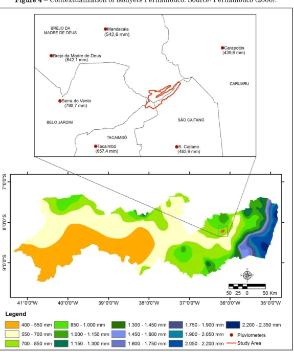
Pernambuco Agreste, a climatic transition zone between the humid forest zone and the Hinterland semiarid region, an area with large spatial variations of the historical annual average rainfall, as can be seen from the Figure 4.
Among the rainfall stations shown in Figure 4, the closest Monument Natural Pedra do Cachorro is the post "São Caetano", lying approximately 10 km from the study area. The historical average annual rainfall for this position is 483,9 mm, which represents values similar to those found in the backwoods of San Francisco, which is the driest region of Pernambuco. The post "Carapotós" which is 12 km from Monumento Natural Pedra do Cachorro, has an even lower historical average, 439,6 mm a year. On the other hand, put the "Mandacaia" (17,5 Km away), "Tacaimbó" (distant 15 Km), "Serra do Vento" (distant 20 Km) and "Brejo da Madre de Deus" (distant 22 Km) presenting historical averages higher precipitation, as shown in Figure 4.
From Figure 5 it can be seen that even with a spatial variation of the total annual rainfall, the monthly distribution follows a pattern, with the period of higher incidence of concentrated rainfall between March and July, are the winter fall rains (the southern hemisphere) that affect the entire eastern facade of the Northeast. Spring appears as the driest season of the year.
Among the six Climograph shown in Figure 5, the annual course of average temperatures also features a standard, with monthly averages that do not exceed 26°C in the warmer months, and not fall below 19ºC in the colder months.
Figure 4 – Contextualization of isohyets Pernambuco. Source: Pernambuco (2006).
The large spatial variation of annual rainfall average in rainfall stations surrounding the Monument Natural Pedra do Cachorro is due in large part to the rugged terrain of the Plateau of Borborema, which creates an exposure to the predominant flow of wind (direction SE in good of the year in this region), a phenomenon that became known locally as "effects of windward and leeward."
Andrade and Lins (2001) state that, in nautical language is the upwind edge of the
vessel lies on the side where the wind blows, while the opposite side is the leeward. The slopes of the mountains that are exposed to the wind flow (the windward is where the air rises, cools and condenses) receive higher rainfall throughout the year than the strands that are on the side leeward, where the air descends more heated, the which hinders the formation of rain.
Figure 5 – Climograph surrounding the Monument Natural Stone dog. Source: Department of Atmospheric Sciences at the Univ. Federal University of Campina Grande (2014).
2. Geology and relief
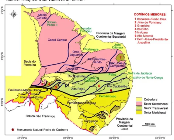
The Natural Monument Pedra do Cachorro is inserted, geologically, the area Capibaribe River, part of the cross section of the Borborema Province. The Borborema Province (or Orogenic Borborema System) is a mosaic of grounding portions of micro continents and orogenic tracks of Archaean to Neoproterozoic separated by transcurrent shear zones and push. In the Network shear zones, the biggest match called lineaments Patos and Pernambuco, which
delimit the three sectors of Borborema: the cross-sector, confined between the two lineaments; the northern sector, north of the lineament and ducks; the southern sector, south of Pernambuco lineament (HASUI et al., 2012). From Figure 6 can view the Monument Natural Pedra do Cachorro situated in the area
Capibaribe River, near the lineament
Figure 6 – Natural Monument location Pedra do Cachorro on Borborema Province. Source: Adapted from Hasui et al. (2012).
The main lithology Monument Natural Pedra do Cachorro consists of plutonic igneous rocks Batholith Caruaru, Arcoverde (Figure 7),
highlighting the rocks Alkali-feldspar granite
type, Diorite, syenogranite Granite
Granodiorite, monzonite. Figure 7 – Geological Aspects. Source: Towers and Pfaltzgraff (2014).
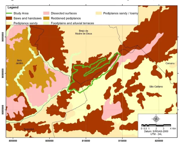
The Plateau of Borborema is the main feature of the regional relief. Considering the relief subdivision proposal on environmental Units can be said that the Natural Monument Pedra do Cachorro is represented by Geoenvironmental Unit of blades and saws, and its surrounding area dominated by Pediplanos Sandy/loamy, Pediplanos Sandy, Pediplanos Reddish (medium and clayey), the Dissected Surfaces besides the Floodplains and Alluvial terraces, as can be seen from Figure 8.
The highest regional altitudes are checked on the hills and saws, and Monument Natural Dog Rock are found maximum quota of 950m
altitude. Figure 9 is the altimetry surrounding the Monument Natural Pedra do Cachorro, through which you can observe higher areas in the eastern portion and more recessed areas in the northern portion.
The slopes are also more pronounced in the mountains and saws, reaching 40º at the Monument Natural Pedra do Cachorro, relief may be classified as "Mountainous" (25 to 45º). In the northern portion of the surrounding area, on the other hand, the slopes are much more mild, ranging between 0 and 10º, the relief may be classified as plan rippled or Wavy Soft, as can be seen from Figure 10.
Figure 9 – Altimetry. Source: Satellite Images ASTER / GDEM.
3. Soil and agricultural potential
The soil class predominantly found in Monument Natural Pedra do Cachorro is the class of Litholic Neosols, as can be seen from Figure 11. In its surrounding area are frequent Planosols, Neossolos Regolíticos, Argissolos Red Yellow and Fluvisols.
The Litholic Neosols, which are the most representative soils of the Monument Natural Pedra do Cachorro specifically and predominate throughout Geoenvironmental Unit of "Serras e Serrotes" are shallow soils or very shallow, with horizon except chernozemic, seated directly on the rock. The major limitation of these soils is the small effective depth, which hinders root development of plants and crops, difficulty the more significant the closer is the rock surface. These characteristics give the Litholic Neosols little capacity for sustainability of vegetation (SHINZATO et al., 2008). They were classified as "non-agricultural activities" and as very low
potential holders irrigation (EMBRAPA
SOLOS, 2000).
The Planosols are imperfectly or poorly drained mineral soils, whose main characteristic is the presence of a B horizon planic, behind a horizon (A) or (A+E) sandier and an abrupt textural change (EMBRAPA SOLOS, 2000). The horizon planic B is thickened with a high content of clay, which favors water retention by forming a "drop groundwater", the temporary existence. Displays slow permeability or too slow, gray or darkened color, may or may not have reduction in neutral colors, with or without mottling (IBGE, 2007). This condition of poor drainage contributes to increased salt content, with high saturation exchangeable sodium, making them extremely susceptible to salinization/sodification when grown improperly. Faced with the limitations, these soils are rated for "natural pasture" with very low irrigation potential (EMBRAPA SOLOS, 2000).
The Neossolos Regolíticos are mineral soils, not hydromorphic, undeveloped, with relative depth and horizon positioned directly in C or Cr. Are medium and coarse texture, light colors or whitish and minerals easily weathered (potassic feldspar) in the sand fraction and/or gravel (OLIVEIRA; JACOMINE; CAMARGO, 1992). The major limitations to the farming refer to low water storage capacity and nutrients. They have agricultural potential for natural pastures, and a very low potential for irrigation (EMBRAPA SOLOS, 2000).
The Argisols are mineral soils not hidromorphic with variable depth - from shallow to very deep – well–developed that present textural B horizon below the A or E, having the highest content top of sand and bottom larger amount of clay . The variation of sand and clay gives a rapid drain on the slow A and B, allowing greater accumulation of moisture and becomes susceptible to erosion these soils (EMBRAPA SOLOS, 2006). They were classified according to the Agro-Ecological Zoning of Pernambuco, as "arable land of good potential" and "high potential" for irrigation, because they have good physical condition.
The Fluvisols are derived silt soils horizon "A" based on C horizon consisting of layers laminated, pedogenetic relation to each other (EMBRAPA SOLOS, 2006), resulting in soils with very varied nature and physical chemistry. They have sequence horizons A-C, possibly with evidence gleização due to the proximity of water courses, and water table, usually the small depth, being susceptible to possible flooding (SHINZATO et al., 2008).
4. Hydrography
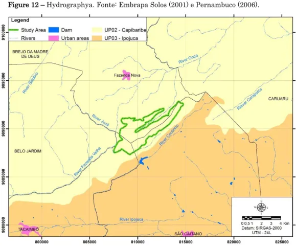
The Natural Monument Pedra do Cachorro is inserted in the basin of the Capibaribe River, near the boundary of this basin with the basin of the Ipojuca River, as can be seen from Figure 12. The predominant drainage pattern is the dendrite and all watercourses 'water has intermittent regimen (CPRM, 2005). In the Monument Natural Pedra do Cachorro surrounding area are found the headwaters drain several streams, especially the Riacho da Onça, Riacho Carapotós, Coutinho Riacho Riacho Jucá and Riacho Fazenda Velha.
5. Biotic aspects
The state of Pernambuco is covered by two biomes: the Mata Atlântica, with tropical evergreen forest; Caatinga, with xerophytic vegetation; and, in the semi-deciduous tropical forest in the wild. The vegetation Cachorro Serra is Caatinga hypoxerophytic, bushes and trees, with clips from Deciduous Forest, with the presence of plant species characteristics of the savanna in good condition.
The Conservation Unit (UC) Natural Monument (MONA) Pedra do Cachorro, comprises in its limits the PRNP Pedra do Cachorro, located on the outskirts of São Caetano, with an area of approximately 17 hectares. In this UC are conducted environmental education activities, ecotourism and adventure tourism, and scientific research by several entities.
The Pedra do Cachorro, within the limits of MONA, with more than 1.000 m high, has great importance for adventure tourism, on has one of the largest climbing routes of Pernambucano Hinterland approximately 400m, called "Ilusão
do Sertão", which takes advantage of the great landscape and scenic rocky outcrop. Figure 12 – Hydrographya. Fonte: Embrapa Solos (2001) e Pernambuco (2006).
The main criteria for defining the perimeter to create the Conservation Unit took into account the use of soil properties, areas with native vegetation of the Caatinga, the scenic beauty of the rocky outcrop and cave paintings, which preserve the historical memory of ancestors who inhabited the region.
The vegetation existing Caatinga in Cachorro Saws and Moleque coincides with elevation areas from various topographical quotas Charter planialtimetric of Belo Jardim, SC Sheet. 24-X-B-III (MI–1369) 1:100.000 scale developed by SUDENE in 1986 with data provided by the Directorate of the Army Geographical Service – 3rd Survey Division.
The villages of Santa Luzia, Onça, Jardim da Onça, Saco da Serra, Retiro, Fazenda Velha, Barra do Jucá, Boqueirão e Boqueirãozinho are
close to the Saws do Cachorro and Moleque and agricultural activity in the region is mainly composed by corn, beans and palm and the creation of cattle, goats and sheep, for subsistence.
The present biogeographical provinces in Brazil (CABRERA & WILLINK, 1973), the Caatinga, with approximately the same limits
of semiarid climate of the Brazilian
northeasterns area is one of the largest and most unknown. Its varied vegetation is largely determined by climate, topography and geological basis that, in its multiple interrelations result in ecologically different environments.
The vegetation in the central untamed state of Pernambuco is mainly composed of Caatinga hypoxerophytic characterized by tree and shrub
training, adapted to water scarcity, which loses its leaves in the dry season (FIDEM, 2011). The Caatinga also corresponds to most of the vegetation of the Borborema plateau, and consists of a Caatinga with high size and a sharp floristic richness (MMA, 2004).
In 2009 it started floristic survey in the PRNP Pedra do Cachorro. Preliminary data from this survey indicate that the rocky outcrop of Pedra do Cachorro has high species richness when compared to other rocky outcrops studied in Caatinga, identified species restricted to these environments as phosphorea Euphorbia, Mandevilla dardanoi, Acianthera proliferates
and Ameroglossum pernambucense
(Scrophulariaceae), and Epidendrum fulgens.
(Orchidaceae), a new quote for the
Northeasterns (MENDES & ALVES, 2010). 104 species in 48 families were identified.
Orchidaceae (10 SP.), Euphorbiaceae,
Leguminosae (9 spp. Each), Bromeliaceae (7 spp.) And Apocynaceae (6 spp.) Are the richest families in species. Some species are noticeably more abundant, such as Euphorbia phosphorea,
Cnidoscolus loefgrenii (Euphorbiaceae),
Acianthera ochreata (Orchidaceae), Tillandsia
recurvata (Bromeliaceae) and dardanoi
Mandevilla (Apocynaceae).
In the exposed portion of the outcrop vegetation is arranged in varying shapes islands with shallow depressions or cracks in soil in the rock. In the surroundings they are found tree species that can reach up to 6 m high (MENDES & ALVES, 2010).
Moreover, in the PRNP was identified the existence of a new species of Orchidaceae family, flammeus Epidendrum, which occurs in rocky outcrops in the Borborema Plateau, from
1.000m above sea level, the color of the flower varies from yellow, orange to red intense (ALVES et al., 2012).
The survey also indicated the existence of endemic species and endangered the rocky outcrop, as well as vegetation Caatinga in good condition surrounding the outcrop, with endemic and typical species of the biome. According to Mendes & Alves (2010) preliminary data confirm the importance of the area for biodiversity conservation of the Caatinga, biome inadequately represented by protected areas.
In addition, survey of Bryophytes (liverworts and mosses) held in PRNP Pedra do Cachorro indicate that the rocky outcrop of Pedra do Cachorro was one of the outcrops of greater wealth in bryophytes in the state of Pernambuco, with 20 species, so the region has great relevance to biodiversity conservation.
The drastic reduction in natural areas of the Caatinga biome, determined by human action, there is good prospects for conservation, since the loss of biological and genetic diversity leads to reduction in the adaptability of species to environmental changes, dramatically increasing the extinction possibilities.
For a long time the Caatinga was seen as a poor Biome without its own fauna, but recent studies have shown that the Caatinga is diverse with faunal elements adapted to dry conditions and particular information on their life history, however little is known about these mechanisms adaptation to most taxa (MMA 2001).
These studies indicate that the Caatinga of vertebrate fauna is made up of 240 species of fish, 51 amphibians, 116 of reptiles, 510 of birds, and 347 exclusive Biome and 148 of
mammals, there is no much information about the invertebrates.
The group of Lepdopteras is the second largest order of insects about 146.000 described species, of these 13% correspond to the butterflies and the rest of the moths. Butterflies are often used as indicators in conservation programs due to easy and fast sampling, known biology and ecology and sensitivity to environmental changes (SILVA et al., 2009).
In the survey of species of butterflies in the PRNP were collected 1.004 individuals in 12 Orders of the Class Insecta, with 298 of the Lepidoptera order, 206 Hymenoptera, 172 Coleoptera, 104 Hemiptera, 78 Diptera, 77 Orthptera, 38 Odonata, 17 Neuroptera, 4 Blattodea , 4 Mantodea, 3 Mecoptera and 3 Phasmatodea. Order Lepidoptera of six families of butterflies were recorded, 126 individuals representing the Nymphalidae family, 91 Pieridae, 40 Hesperiidae, Papilionidae 17, 13 and 11 Satyridae Lycaenidae.
The survey results showed that the PRNP houses a wealth of butterflies which reinforces the importance of conservation of this natural area (SILVA et al., 2009).
6. Contextualization in the State System of Conservation Units (SSCU)
The State System of Conservation Units – SSCU was established by State Law No. 13,787 of June 8, 2009, it being understood by Conservation Unit – UC the "territorial space and its environmental resources, including jurisdictional waters, with features relevant natural, legally instituted by the Government, with conservation objectives and defined limits,
under a special administrative regime, which is subject to appropriate guarantees of protection". Conservation Unit – UCs members of the State System of Conservation Units – SSCU divided into strictly protected areas and sustainable use units. All categories have defined objectives and specification of conservation features and management of the area. These criteria are essential for defining the category of conservation unit that best fits the proposed area.
Among the categories that SSCU category Natural Monument – MONA covers biodiversity
protection objectives ally to promote
environmental education, ecotourism and
adventure tourism activities already
implemented so ignorant in the region.
Although framed in the group of full protection conservation units, the category Natural Monument – MONA stands out for maintaining the private property in the possession of their owners, provided that the use of land and natural resources in these areas is consistent with the law protection of nature and the management plan for the unit.
The Natural Monument is the basic objective preserve rare natural sites, natural or of great scenic beauty, according to the SSCU (Art. 12). The same law states that the public visits in this category of UC will be subject to the rules and restrictions set out in Unit Management Plan, the rules established by the body responsible for its administration and those provided for by regulation.
The creation of the Conservation Unit at the Pedra do Cachorro besides increasing the representativeness of the Caatinga legally
protected in the state of Pernambuco, reconcile the preservation of biological diversity and the use of natural resources with ecotourism and adventure tourism have developed in the region and with great potential for expansion.
REFERENCES
ALVES, M. et al. Integrating different tools to disentangle species complexes: A case study in Epidendrum (Orchidaceae). TAXON 61 (4) 721–734, 2012.
ANDRADE, G. O; LINS, R. C. Introdução ao Estudo dos Brejos Pernambucanos. Revista de Geografia. Recife, UFPE/DCG-NAPA, v. 16, n. 1, jun/dez, p.5-25, 2001.
CABRERA, A.L. & WILLINK, A. Biogeografia da America Latina. 2º ed. OEA, Washington, 1973. CPRM. Serviço Geológico do Brasil. Projeto cadastro de fontes de abastecimento por água subterrânea. Diagnóstico do Município de São Caetano, Estado de Pernambuco. Recife, 2005.
EMBRAPA SOLOS. Sistema Brasileiro de
Classificação de Solos. 2.ed. Rio de Janeiro, 2006. EMBRAPA SOLOS. ZAPE Digital. Zoneamento Agroecológico do Estado de Pernambuco. Recife, 2001.
EMBRAPA SOLOS. Levantamento de
reconhecimento de baixa e média intensidade dos solos do Estado de Pernambuco. Rio de Janeiro, 2000. GUERRA, A. T; GUERRA, A. J. T. Novo dicionário geológico-geomorfológico. 3.ed. Rio de Janeiro, Bertrand Brasil, 2003.
IBGE. Instituto Brasileiro de Geografia e Estatística. Manual técnico de pedologia. Rio de Janeiro, 2007. MENDES, K. & ALVES, M. Inventário Florístico em
Afloramento Rochoso na Caatinga: Dados
preliminares. Anais... do 61° Congresso Nacional de Botânica. Manaus, 2010.
MMA – Ministério do Meio Ambiente – Brasil. Avaliação e Ações Prioritárias para a Conservação da Biodiversidade da Caatinga. Brasília: UFPE, 2001. MMA – Ministério do Meio Ambiente. Biodiversidade da Caatinga: Áreas e ações prioritárias para a conservação. Brasília: UFPE, Fundação de Apoio ao Desenvolvimento, Conservation International – Fundação Biodiversitas, EMBRAPA – Semiárido, MMA/SBF. Brasil, 2004.
OLIVEIRA, J.B.; JACOMINE, P.K.T.; CAMARGO, M.N. Classes gerais de solos do Brasil: guia auxiliar para seu reconhecimento. Jaboticabal-SP, Funep, 1992.
PERNAMBUCO. Atlas de bacias hidrográficas de Pernambuco. Recife, Secretaria de Ciência, Tecnologia e Meio Ambiente, 2006.
SHINZATO, E.; CARVALHO FILHO, A.; TEIXEIRA, W. G. Solos Tropicais. in: SILVA, C. R. Geodiversidade do Brasil: conhecer o passado para entender o presente e prever o futuro. Rio de Janeiro: CPRM, 2008.
SILVA, F.A, et al. Registro das Borboletas no Ecossistema de Caatinga da Reserva Particular do Patrimônio Natural Pedra do Cachorro, São Caetano, Pernambuco. Recife, 2009.
SUDENE – Superintendência do Desenvolvimento do Nordeste. Carta Planialtimétrica de Belo Jardim: Folha SC.24-X-B-III (MI-1369) 1:100.000. Brasil, 1986.