SRef-ID: 1684-9981/nhess/2005-5-309 European Geosciences Union
© 2005 Author(s). This work is licensed under a Creative Commons License.
and Earth
System Sciences
Slope processes and related risk appearance within the Icelandic
Westfjords during the twentieth century
A. Decaulne
G´eolab, Clermont-Ferrand cedex, France
Received: 7 September 2004 – Revised: 1 March 2005 – Accepted: 15 March 2005 – Published: 29 March 2005 Part of Special Issue “Multidisciplinary approaches in natural hazard and risk assessment”
Abstract. In North-western Iceland, records of slope pro-cesses were increasing during the twentieth century. Few dramatic events during the last decades highlighted the dan-ger due to slope dynamics, leaving local populations in a risk situation that was merely unknown before 1970. The recent snow-avalanche, debris-flow and rock-fall activity un-derlined that the most frequent processes are not these with the largest human impact. In fact, the most catastrophic events were the extreme ones, following directly from a low frequency and a high magnitude. The purpose of this pa-per is to draw a parallel history of natural hazard and resi-dence spatial extension, for an accurate understanding of the present-day risk situation, as the population growth markedly increased during the same time. Different quantitative and qualitative methods are applied. Geomorphological investi-gations locate the main threaten areas, in the path of slope processes release evidences, i.e. suitable slope morphol-ogy and/or inherited/actual forms. By a collection of dating data, as historic records and lichenometrical analysis, the fre-quency of given magnitude events is known. Climatic analy-sis clarifies the triggering meteorological conditions of slope processes and offers an overview of climate fluctuation dur-ing the investigated period; wind speed and direction is crit-ical to hazardous snow-avalanche departure and snowmelt is crucial for debris-flow release. The findings clearly indicate that a combination of spatial expansion of inhabited areas and a lack of slope processes knowledge at the expansion time led to a recent and progressive risk appearance due to snow avalanches (including slush flows), debris flows and rock fall in most towns and villages of North-western Ice-land.
1 Introduction
During the last century, coastal villages and urban nuclei of northwestern, northern and eastern Iceland have been
Correspondence to:A. Decaulne (armld@yahoo.fr)
severely concerned by recurrent snow-avalanche and debris-flow activity, its catastrophic effects being on the increase with time (Decaulne, 2004b). This paper aims to highlight the appearance of risk due to these slope processes, espe-cially in the fjords area of northwestern Iceland, during the twentieth century, based on the study of the parallel history of natural hazards and residence extension.
The study area (Fig. 1) is located at subpolar latitude, in the mid North-Atlantic (66◦N–23◦W). This northern
loca-tion has both climatic and morphologic implicaloca-tions. As a subpolar oceanic climate, the weather in the northwestern part of Iceland is perturbed, as the area lies on the main low pressure trail, contributing to high temperature and pre-cipitation variation over a short time period throughout the year. The superimposed basaltic lava flows of the area ex-perienced Quaternary glacial conditions, during which the coastline was shaped into numerous and deep fjords. Thus, slopes are steep, and debris availability is high, due to large supplies in both inherited glacial products and actual frost shattering. The elevation varies from 400 to 700 m, with flat summits. The slope upper part is steep, joining a rockwall. In the lower part are steep and slightly concave talus slopes. In some cases, a bench interrupts the upper rockwall, covered with a thick debris mantle. The upper edge is cut by numer-ous chutes, of varying width. Human settlements occupy the thin area between the sea and the mountain slopes. All these conditions are prone to snow-avalanche and debris-flow ac-tivity in the northwestern part of Iceland, and exacerbate the risk.
2 Methods
64˚N 66˚N
22˚W 18˚W 14˚W
Polar Arctic Circle
Atlantic O cean
D enmark Straits 0 25 km
300 m
600 m
900 m
N
Elevations in metres30 m
Súðavík Ísafjörður Hnífsdalur Bolungarvík
Flateyri
Bíldudalur Patreksfjörður
Fig. 1.Location of the study area.
Table 1.The number of potential snow-avalanche and debris-flow tracks in the five studied areas of the Icelandic Westfjords.
Sites No. of snow avalanches No. of debris flows
Patreksfjordur 9 18
Bildudalur 5 15
Bolungarvik 8 16
Hnifsdalur 5 17
Isafjordur 24 35
Table 2. The snow-avalanche and debris-flow track density in the five studied areas of the Icelandic Westfjords.
Sites Snow-avalanche density Debris-flow density
km−1 km−1
Patreksfjordur 3.6 7.2
Bildudalur 2.8 8.6
Bolungarvik 4 8
Hnifsdalur 1.4 4.7
Isafjordur 11.4 16.6
interpretation, various reports study, location and descrip-tion of both erosive and accumulative landforms, drawing out snow-avalanche and debris-flow paths. Using this infor-mation, maps are drawn, showing the main tracks and the outline of the larger recognised runout distances.
The temporal distribution of slope processes is known with the help of absolute dating, primarily extracted from writ-ten sources such as slope processes reports, newspapers and chronicles that multiply during the twentieth century. Gov-ernmental institutions compiled most of these data
(Agust-son et al., 2002, 2003a, b; Arnalds, 2002; Peturs(Agust-son, 1991, 1992a, b, 1995, 1996; Petursson and Saemundsson, 1999; Petursson and Jonsdottir, 2000a, b; Petursson and Jonsson, 2001). The use of lichenometry (Rhizocarpon geograph-icumspecies) and vegetal cover measurements provide rel-ative dating of the deposits related to snow avalanches and debris flows (Decaulne, 2001b; Decaulne and Saemundsson, 2003).
The access to historical data, such as old maps and pho-tographs, census, cadastral and local chronicles (Grimsdot-tir, 1999; Geirsdot(Grimsdot-tir, 2000a, b, c), give precious information on human spatio-temporal distribution from the end of nine-teen century in the studied villages and urban nuclei of the northwestern peninsula.
From a compilation of all deterministic and historic data, overall maps are drawn.
3 Results
3.1 Slope processes spatial-temporal distribution
sites are severely affected by debris flows, Hnifsdalur in a smaller proportion than others.
Mainly derived from written sources, snow-avalanche (Fig. 3) and debris-flow (Fig. 4) occurrence in the five dif-ferent localities underlines the scattered number of reported events through the last century, and the increasing number of documented events with time, specifically after 1980. This observation is more marked for snow avalanches than for debris flows, which are more seldom announced by local population or authorities. Depending on the location, the snow-avalanche return period varies from 1.44 in Isafjordur to 7 years in Patreksfjordur, and the debris-flow return period varies from less than 1 year in Isafjordur to about 35 years in Patreksfjordur (Decaulne, 2004b).
3.2 Human spatio-temporal distribution
The human spatio-temporal distribution in the Westfjords ur-ban nuclei and rural areas passed through radical changes since the 1880s. The population constantly grew up until the 1980s, when the number of inhabitants reaches its maxi-mum (Fig. 5a). During the same period, the population den-sity increased continually (Fig. 5b). Over this time, the pop-ulation behaviour is closely dependent on economic situa-tion, mainly related to fishing industry: in the small town of Bolungarvik, the decrease in population at the beginning of the last century is likely due to a local exodus of fishermen families towards other parts of the Westfjords, due the late construction of a wharf, while similar facilities were built in other places, allowing the docking of motorboats.
The building curves (Fig. 5c) show a different evolution, which increases in stages to reach its maximum during the 1980s, while the population is the most numerous. The build-ing density shows the same growth (Fig. 5d), with a sud-den increase during the 1970s and stabilisation during the 1980s. The first built areas are mainly scattered along the seashore, with subsequent expansion concentrated close to the sea (harbour constructions) and later extending to the mountain slopes, where more various economic activities are developing.
3.3 Risk appearance
When combining the slope processes and human data to-gether, a spatial conflict appears. The inhabited areas extend to the slopes, while slope process deposit areas extend to the bottom of the slopes: the thin area close to the sea that is fit for residence is both influenced by human development and snow avalanches or debris flows. During the twentieth cen-tury, the increasing superimposition of human and natural ac-tivities at the foot of slopes has created an obvious problem, by exacerbating the risk. This scenario is common to all ur-ban nuclei of the study area, but a more detailed examination of Patreksfjordur and Isafjordur diachronic maps illustrates the progressive appearance of risk due to slope processes, as the inhabited areas have been developed in locations that are influenced by natural processes.
0 25 km
300 m
600 m
900 m
N
Elevations in metres
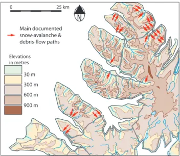
30 m Main documented snow-avalanche & debris-flow paths
Fig. 2. Location of documented snow-avalanche and debris-flow paths in North-western Iceland (refer to figure 01 for the location of studied areas).
In 1900, Patreksfjordur (Fig. 6a) consisted of only a small amount of inhabitants, gathered together along the sea. Only two events were known at this time. In 1950 (B), some more events were registered, especially two snow avalanches that reached the sea in the harbour area, and a debris flow that reached the uppermost houses on the main road. By 1980 (C), the town had grown, and the areas that were crossed by slope processes along the sea were from then on clearly oc-cupied with residential and industrial buildings. Since 1980 the inhabitant and building density had increased and more events were recorded, especially two slush flows that caused 4 fatal accidents (D).
This pattern of evolution is more or less equivalent in Isafjordur. In 1900, it was rather a small village of 500 peo-ple, gathered together on the gravel spit (Fig. 7a). No snow avalanches or debris flows were recorded then. In 1950 (B), the settlement extended to the bottom of slope, and inside the valley to the southwest. In 1980 (C), the density of pop-ulation increased on the lower slope of the main part of the town; moreover, a residential area was built at the bottom of a 400 m high slope. More debris-flow and snow-avalanche events were recorded. In 2003 (D), a larger number of snow avalanches and debris flows were recorded, and the danger-ous areas, i.e. where snow-avalanche and debris-flow deposit area superimposes the residential area, are wide.
1 9 0 0 s 1 9 1 0 s 1 9 2 0 s 1 9 3 0 s 1 9 4 0 s 1 9 5 0 s 1 9 6 0 s 1 9 7 0 s 1 9 8 0 s 1 9 9 0 s 2000s 0 2 4 6 8 10 0 2 4 6 0 2 4 6 0 2 4 No
. of r
e c o rded sno w a v alanches 0 2 4 6 8 Isafjordur Bildudalur Bolungarvik Patreksfjordur Hnifsdalur
Fig. 3.Snow-avalanche temporal distribution in North-western Iceland.
1 9 0 0 s 1 9 1 0 s 1 9 2 0 s 1 9 3 0 s 1 9 4 0 s 1 9 5 0 s 1 9 6 0 s 1 9 7 0 s 1 9 8 0 s 1 9 9 0 s 2000s
0 2 0 2 4 0 2 0 2 4 6 8 10 12 36 38 N o . o f re co rd e d d e b ri s fl o w s 0 2 Bolungarvik Isafjordur Bildudalur Patreksfjordur Hnífsdalur
Fig. 4.Debris-flow temporal distribution in North-western Iceland.
Isafjordur Bolungarvik Bildudalur Patreksfjordur
n o . o f i n h ab it an ts 0 500 1000 1500 2000 2500
1881 1891 1901 191
1
1921 1931 1941 1951 1961 1971 1981 1991 2001 B Evolution of population density
years 0 100 200 300 400 500 600 700
1881 1891 1901 191
1
1921 1931 1941 1951 1961 1971 1981 1991 2001 Evolution of building density D years n o . o f b u ild in g s p o p u la ti o n d en si ty (h ab /k m ²) b u ild in g d en si ty (b u ild in g s/ km ²) 0 500 1000 1500 2000 2500 3000 3500
1881 1891 1901 191
1
1921 1931 1941 1951 1961 1971 1981 1991 2001 A
C
B
D Evolution of population number
years 0 100 200 300 400 500 600
1881 1891 1901 191
1
1921 1931 1941 1951 1961 1971 1981 1991 2001 Evolution of buildings number
years
KEYS Snow-avalanche outline Slush-avalanche outline Debris-flow outline Inhabited area Contour lines = 20 m
250 m N 250 m N
250 m N 250 m N
A A
C
B
D Patreksfjordur in 1900
Patreksfjordur in 1980
Patreksfjordur in 1950
Patreksfjordur in 2003
Fig. 6.Diachronic maps of the site of Patreksfjordur.
KEYS Snow-avalanche outline Debris-flow outline Inhabited area Contour lines = 20 m
N 250 m
N
250 m 250 m N
N 250 m A Isafjordur in 1900
C Isafjordur in 1980
B Isafjordur in 1950
D Isafjordur in 2003 A
C
B
D
No
. of sno
w-a
v
alanche vic
tims
1 9 0 0 s 1 9 1 0 s 1 9 2 0 s 1 9 3 0 s 1 9 4 0 s 1 9 5 0 s 1 9 6 0 s 1 9 7 0 s 1 9 8 0 s 1 9 9 0 s 2000s
0 2 4 6 8 10 0 2 4 6
0 2 4 6 0 2 4
0 2 4 6 8 10 12 14 16 18 20 22 24 26 28 30 32
Isafjordur Bildudalur
Bolungarvik Patreksfjordur
Hnifsdalur
B Distribution of snow-avalanche victims
No
. of r
e
c
o
rd
ed destruc
tiv
e sno
w a
v
alanches
1 9 0 0 s 1 9 1 0 s 1 9 2 0 s 1 9 3 0 s 1 9 4 0 s 1 9 5 0 s 1 9 6 0 s 1 9 7 0 s 1 9 8 0 s 1 9 9 0 s 2000s
0 2 4 6 8 10 0 2 4 6
0 2 4 6 0 2 4
0 2 4 6 8
no. of recorded snow-avalanche events
Isafjordur Bildudalur
Bolungarvik Patreksfjordur
Hnifsdalur
A Distribution of recorded destructive snow avalanches
caught with the avalanche / Injured killed A
B
Fig. 8.Recorded destructive and fatal snow avalanches in North-western Iceland.
4 Discussion
From the presented results, an obvious risk situation arose during the second half of the last century. This situation is due to a combination of snow-avalanche/debris-flow activity and residence location. Nevertheless, the increasing number of recorded events with time during the 20th century could be explained by the increasing land occupation during the same period, as both trends are parallel: at the beginning of the 20th century, people moved from place to place more than
they did before, as commercial exchanges and fishing indus-try grew; moreover, from the 1940s, people reside in areas that were previously uninhabited, and residents noticed more events while they became more susceptible to slope pro-cesses because of snow-avalanche and debris-flow deposits in fields, material or human damages. Then, the number of documented or reported events is a function of the population density in a specific area.
no. of recorded debris-flow events
A Distribution of recorded destructive debris flows
No
. of r
e
c
o
rded destruc
tiv
e
debris flo
ws
1 9 0 0 s 1 9 1 0 s 1 9 2 0 s 1 9 3 0 s 1 9 4 0 s 1 9 5 0 s 1 9 6 0 s 1 9 7 0 s 1 9 8 0 s 1 9 9 0 s 2000s 0
2 4 6 0 2 4 0 2
0 2 4 6 8 10 12 36 38 0 2
Bolungarvik
Isafjordur Bildudalur Patreksfjordur
Hnífsdalur
B Distribution of debris-flow victims
No
. of debris-flo
w vic
ti
ms
1 9 0 0 s 1 9 1 0 s 1 9 2 0 s 1 9 3 0 s 1 9 4 0 s 1 9 5 0 s 1 9 6 0 s 1 9 7 0 s 1 9 8 0 s 1 9 9 0 s 2000s 0
2 4 6 0 2 4 0 2
0 2 4 6 8 10 12 36 38 0 2
Bolungarvik
Isafjordur Bildudalur Patreksfjordur
Hnífsdalur
A
B
Fig. 9.Recorded destructive and fatal debris flows in North-western Iceland.
are putting themselves in danger because they do not un-derstand the natural slope activity, despite the numerous landforms visible on slopes that clearly indicate that snow avalanches and debris flows are active (Decaulne, 2001a, b, 2002, 2003; Decaulne and Saemundsson, 2003; Saemunds-son et al., 2003). At this stage, it seems obvious that the impact of slope processes on different people is different ac-cording to different perceptions and points of view, for the geomorphologist, the slope processes impact on population, so vulnerability and risk is a combination of occurrence fre-quency and magnitude. For the inhabitants, the risk is a question of calamitous events frequency. Then, without go-ing far into psychological aspects, the risk perception is dif-ferent according to social or geomorphic issues (Rohrmann, 1999). Here, a comparative study is undertaken on the five sites, highlighting the number of recorded destructive snow avalanches, i.e. those that caused material damages (broken fences, houses, cars), and number of recorded fatal snow avalanches (Fig. 8). The same study is carried out for de-bris flows, underlining the low number of destructive events and the absence of victims (Fig. 9). Two observations can be
made: (1) fatal accidents were very rare and scattered dur-ing the last century, and (2) the construction period was very calm. Then the impact of slope processes was very low on inhabitants. Moreover, the debris flow impact is lower than that of snow-avalanches, in term of risk understanding. This situation is worsened by the scattered direct impact on local population, which puts a curb on risk awareness.
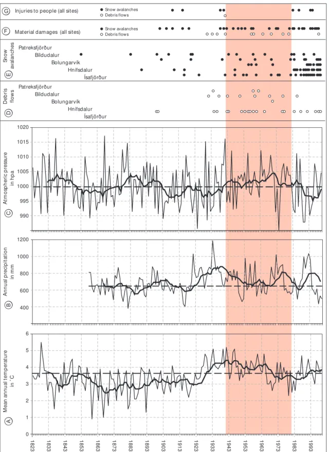
Regarding the construction period, from 1940 to 1980, it corresponds to the most favourable climatic space of time: on figure 10, the climatic trends from 1823 in the oldest me-teorological station of Iceland, Stykkisholmur, in the north-ern bank of the Snaefesllnes peninsula (75–100 km from the study area), are shown. The trend is parallel to that from Westfjords data, where the temperature values are 0.5◦C
lower. The mean annual temperature (A) rose more than 1◦C from the 1920s to the 1970s. The mean annual
0 1 2 3 4 5 6
18
23 1833 1843 1853 6318 1873 1883 1893 1903 1913 1923 1933 1943 5319 1963 1973 1983 1993
400 600 800 1000 1200 990 995 1000 1005 1010 1015 1020
Patreksfjörður Bíldudalur
Bolungarvík Hnífsdalur
Ísafjörður Patreksfjörður
Bíldudalur Bolungarvík
Hnífsdalur Ísafjörður
Snow avalanches Debris flows
Debris flows Snow avalanches
M
ea
n
a
n
n
u
al
t
em
p
er
at
u
re
in
˚
C
A
A
tm
o
sp
h
er
ic
p
re
ss
u
re
in
h
p
a
C
A
n
n
u
al
p
re
ci
p
it
at
io
n
in
m
m
B
Sn
o
w
av
al
an
ch
es
E
Material damages (all sites) F
Injuries to people (all sites) G
D
eb
ri
s
fl
o
w
s
D
main points of this study, highlighting that the larger num-ber of events is recorded at the end of the 20th century (D, E), that material damages and accidents are scattered (F), and that injuries to people caused by slope processes (G) are even more seldom. Just before the settlement expansion (1920–1940), temperatures were rising, so precipitation was likely to be less snowy and major avalanches have not been recorded. Local events occurred. The next period (1940– 1980) was particularly favourable for settlement expansion, as previously mentioned, in terms of the weather. Moreover, if snow avalanches and debris flows were reported, this pe-riod did not record any fatal accidents, which could have discouraged the settlements on lower parts of slopes. It is only at the end of this period that fatal accidents occurred, together with lower temperatures and atmospheric pressures, and higher precipitation. Nevertheless, more studies are nec-essary to estimate and predict the influence of future climate trends and changes on slope processes, and then risk impli-cations, in this area.
5 Conclusion
The progressive appearance of risk, and the observed risk situation in the Icelandic Westfjords are not unusual: the oc-currence of slope processes was unknown before the settle-ment expansion in most places, and, during the expansion period, the low frequency of extreme events combined with the economic expansion of the area, did not help a popular awareness of danger.
But today, at the beginning of the 21th century, most of the localities of northwestern Iceland are comparatively well-protected in terms of the inhabitants. This quick turnaround is the consequence of a sudden awareness of risk by the local inhabitants and the national authorities. This could be due to 3 fatal accidents in a range of 15 km around Isafjordur dur-ing 3 successive winters: in Isafjordur, in early April 1994, the Tungudalur snow avalanche caused the death of one per-son, and the destruction of more than 30 summerhouses; in the village of Sudavik, in mid-January 1995, 14 people lost their lives (almost 1/10 of the population); in Flateyri, in mid-October 1995, 20 people lost their lives (almost 1/10 of the population).
This raises the question of risk acceptance (Fischhoff et al., 1981; Rohrmann, 1998) by individual and society: be-fore 1995, damages were mainly material, and fatal accidents were rare. After the catastrophic year in 1995, efforts were made to mitigate the risk, especially the risk due to snow avalanches, as they are more frequent than debris flows and have caused severe damage in several communities.
Acknowledgements. Part of this study was supported by the Laboratory of Physical Geography G´eolab CNRS-UMR 6042 and R´eseau Arctique. Valuable discussions with T. Saemundsson are gratefully acknowledged. Thanks are also due to H. G. Petursson, T. Johannesson, O. Petursson, T. Jonsson and H. Grimsdottir, who greatly facilitated access to helpful documents. T. Glade and M. Crozier are acknowledged for their review and comments
on the manuscript, and F. Tweed is thanked for the substantial improvement of the English text.
Edited by: T. Glade Reviewed by: M. Crozier
References
Agustsson, K., Johannesson, T., Sauermoser, S., and Arnalds, Th.: Hazard zoning for Bolungarvik, Technical report, Icelandic Me-teorological Office, VI–UR19, 2002.
Agustsson, K., Johannesson, T., Sauermoser, S., and Sigurdsson, H. Th.: Hazard zoning for Patreksfjordur, Vesturbyggd, Technical report, Icelandic Meteorological Office, VI–UR20, 2003a. Agustsson, K., Johannesson, T., Sauermoser, S., Sigurdsson, H.
Th., and Jensen, E. H.: Hazard zoning for Bildudalur, Vestur-byggd, Technical report, Icelandic Meteorological Office, VI– UR23, 2003b.
Arnalds, Th., Sauermoser, S., Johannesson, T., and Grimsdottir, H.: Hazard zoning for Isafjordur and Hnifsdalur, Technical Report, Icelandic Meteorological Office, VI–UR15, 2002.
Bankoff, G.: Vulnerability as a measure of change in society, Inter-national Journal of Mass Emergencies and Disasters, 21, 20–30, 2003.
Decaulne, A.: M´emoire collective et perception du risque li´e aux avalanches et aux debris flows dans les fjords islandais : l’exemple du site d’Isafjordur (Islande nord-occidentale), Revue de G´eographie Alpine, 89, 63–80, 2001a.
Decaulne, A.: Dynamique des versants et risques naturels dans les fjords d’Islande du nord-ouest, l’impact g´eomorphologique et humain des avalanches et des debris flows, PhD Thesis, Univer-sity of Clermont II, France, 2001b.
Decaulne, A.: Coul´ees de d´ebris et risque naturels en Islande du nord-ouest, G´eomorphologie, 2, 151–164, 2002.
Decaulne, A.: R´ealit´e et perception des risques naturels li´es `a la dynamique des versants dans les fjords d’Islande du nord-ouest, Bull. Ass. G´eogr. Fran., 4, 394–400, 2003.
Decaulne, A. and Saemundsson, Th.: Debris-flow characteristics in the Gleidarhjalli area, northwestern Iceland, in: Debris-Flow Hazards Mitigation: Mechanics, Prediction, and Assessment, edited by: Rickenman, D. and Chen, C. I., Millpress: Rotterdam, 1107–1118, 2003.
Decaulne, A.: Le risque avalancheux en Islande, Bull. Ass. G´eogr. Fran., 1, 75–83, 2004a.
Decaulne, A.: Combining geomorphological, historical and lichenometrical data for assessment of risk due to present-day slope processes, a case study from the Icelandic Westfjords, in: Risk Analysis 4, edited by: Brebbia, C. A., WIT Press: Southampton, 177–186, 2004b.
Decaulne, A.: L’apport des donn´ees g´eomorphologiques et his-toriques `a l’analyse diachronique du couple al´ea-vuln´erabilit´e dˆu aux avalanches et aux coul´ees de d´ebris dans les fjords d’Islande nord-occidentale, Norois, 1, in press, 2005.
Fischhoff, B., Lichtenstein, S., Slovic, P., Derby, S. L., and Keeney, R. L.: Acceptable risk, University Press: Cambridge, 1981. Grimsdottir, H.: Byggingarar husa a Isafirdi, Icelandic
Meteorolog-ical Office, VI-G99014-UR08, 1999.
Geirsdottir, S.: Byggingarar husa a Bildudal, Natural Research Cen-tre of the Icelandic Westfjords of, NV6-00, 2000a.
Geirsdottir, S.: Byggingarar husa a Bolungarvik, Natural Research Centre of the Icelandic Westfjords, NV8-00, 2000c.
Petursson, H.G.: Dr¨og ad skriduannal 1971–1990, Icelandic Mu-seum of Natural History, 14, 1991.
Petursson, H. G.: Skriduannall 1951–1970, Icelandic Museum of Natural History, 16, 1992a.
Petursson, H. G.: Skriduannall 1991–1992, Icelandic Museum of Natural History, 17, 1992b.
Petursson, H. G.: Skriduannall 1993–1994, Icelandic Museum of Natural History, 2, 1995.
Petursson, H. G.: Skriduannall 1925–1950, Icelandic Museum of Natural History, 3, 1996.
Petursson, H. G. and Saemundsson, Th.: Skriduf¨oll a Isafirdi og i Hnifsdal, Icelandic Museum of Natural History, NI-99010, 1999. Petursson, H. G. and Jonsdottir, H. E.: Skriduannall 1900–1924,
Icelandic Museum of Natural History, NI-00018, 2000a.
Petursson, H. G. and Jonsdottir, H. E.: Skriduannall 1995–1999, Icelandic Museum of Natural History, NI-00019, 2000b. Petursson, H. G. and Jonsson, H. B.: Skriduannall 2000, Icelandic
Museum of Natural History, NI-01026, 2001.
Rohrmann, B.: Risk perception research - Review and documenta-tion, Research Center Juelich, RC Studies no. 68, 1999. Rohrmann, B.: The risk notion: epistemological and empirical
con-siderations, in: Integrated Risk Assessment, edited by: Stewart, M. G. and Melchers, R. E., Balkema: Rotterdam, 39–46, 1998. Saemundsson, Th., Petursson, H. G. and Decaulne, A.: