ISSN 11222211--11227733, E-ISSN 22006655--33440099 Article no. 223322111188--663399
http://istgeorelint.uoradea.ro/Reviste/Anale/anale.htm
SPATIAL DYNAMICS OF CRAIOVA MUNICIPALITY.
TRANSFORMATIONS OF THE CITY’S RELATION WITH ITS
PERIPHERIES
C
CrriissttiinnaaŞŞOOŞŞEEAA
University of Craiova, Faculty of Mathematics and Natural Sciences, Geography Department, Craiova, Romania, e-mail: [email protected]
Abstract: The study pursues the spatial coordinates of Craiova municipality’s rhythm of evolution, starting with the medieval period until nowadays, outlining the periods of more accelerated growth and the pattern of territorial expansion, but also the moments of urban involution, their causalities and share in changing the urban structure. There are permanent references regarding the relations between the structural and the functional changes and furthermore, a bilateral regard center-periphery. Starting from the urban heartland surrounding Elca dell, the city expanded by gradually integrating the rural settlements located nearby, undergoing an ascending degree of spatial compactness, continuous restructuring of the urban tissue and spatial readjustment of center-periphery dichotomy, as the demographical augmentations and consequences of economic restructuring imposed it.
Key words: spatial dynamics, periphery, Craiova, urban growth.
* * * * * *
INTRODUCTION
Reflection of the demographical vitality and the ascending economic potential, Craiova municipality’s dynamics and present-day structure are the result of complex natural and socio-economic factors, whose role and share have been modified in time and space, according to historical and political conditioning. The urban heartland has evolved by always being reshaped, firstly by the physical-geographical and secondly by the social, economic and historical aspects. While the first ones imprinted the built up space’s physiognomy, texture and form, the second one influenced the extension, the shrink, the density augmentation within the heartland.
The spatial dynamics has been profoundly influenced by the type of urban growth, which assumed absorbing the adjoining villages, but also the basis on which it developed, a profoundly rural character of the regional setting that these demographical phenomena took place in.
DATA AND METHODS
The complex and often contradictory reality of Craiova and its peripheries has been reconstituted by analysing and comparing old plans of the city and other archive documents (Direcţia Judeţeană Dolj a Arhivelor Naţionale), representative large-scale historical cartographic
documents such as Specht map (1790), Schwantz map (1723) and Szathmary map (1864) (Biblioteca Academiei Române) and historic works. At the same time, this technique has also allowed for the correlation between the present features of the urban morphology and their genesis.
RESULTS
From the point of view of its genesis, Craiova has been included in the category of boroughs, an exchange hub that appeared and developed in a region having profound rural grounds (Cucu, 1970). There can be set out five major stages in the territorial evolution of the settlement, each having its own peculiar characteristics.
a) The pre-urban stage
First of all, the geographical location in itself offers the corresponding information regarding the primary functionality of the settlement. Craiova distinguishes in the urban network between the Carpathian range and the Danube by its localization in a contact area between two major natural units, the Getic Piedmont and the Oltenia Plain, intersecting main strategic, afterwards commecial arteries. These are the main urban triggers which determined the appearance and biased the further spatial development of the city.
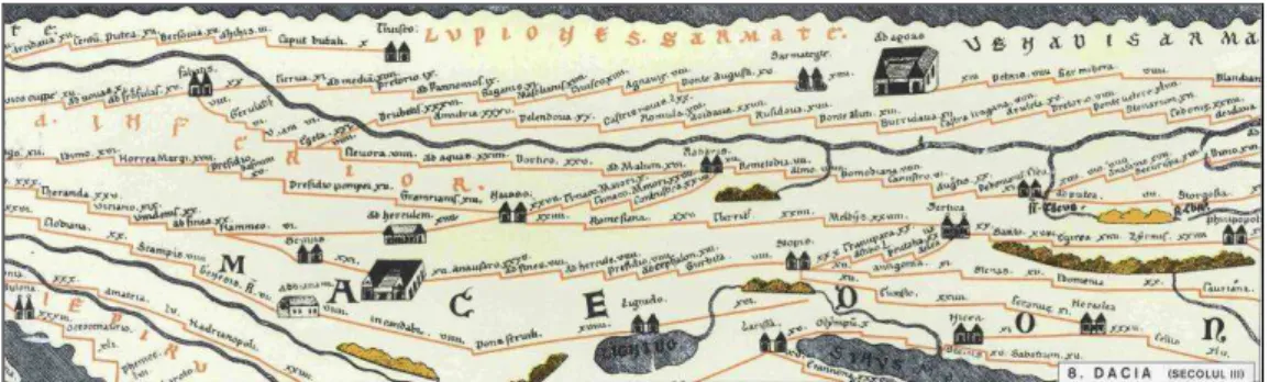
This is doubled by the favourable situm, the low floodplain of the Jiu river and its terraces positively influenced the appearance of the initial core of the settlement and its continuous expansion. The old nucleus was constituted by the Dacian settlement of Pelendava; nearby, at Mofleni, near the church of the old monastery Coşuna, the Romans built a stone and brick castrum, mentioned in Tabula Peutingeriana in the 3rd century A.D (figure 1). This is the place where the roads coming from the Danube (Drobeta) and the Olt rivers (Romula, under nowadays Reşca settlement) interlinked with those heading North, towards Bumbeşti and Schela (Gorj). Crossing the eastern side of the settlement, the „road of the salt” went down from Vâlcea and Gorj towards Calafat and a transhumance road from Novaci and Polovragi headed towards Romanaţi (Cucu, 1970).
Figure 1. A fragment of Tabula Peutingeriana mentioning Pelendava (Source: România. Atlas istorico-geografic, 1996, pag. 68)
In 1263, Vlaicu Vodă reminded the merchants from Braşov about „the ditch of the Jiu river" or „the customs of the Jiu River", confirming some Historians' assumption who identify this place with the customs of Craiova, once again proving the importance of settlement’s commercial function from its initial stage when already recognized as one of the main customs points within the Valachian land (Poncea, 1999).
whose land Craiova was situated (Poncea, 1999); they kept the ancestral lands under control until 1539. The manor of Craiova was appreciated as having “a large extension, with a floristic and faunistic abundance, the forests covering most of the Jiu river’s alluvial plain and terraces” (Deaconu & Otilia, 2000). Its perimeter was bordered by the manors of Craioviţa (belonging at that time to Horezu monastery), Şimnicul de Jos, Teişani, Gherceşti, Smărdăşteţu, Cârcea, Preajba, Jitianu and the Jiu riverbed.
b) The stage of proto-urbanization–the settlement’s detaching from the rural status An indirect information during Neagoe Basarab, an inscription on the tomb of Vladislav 2nd (1446-1456) reminds for the first time the name of Craiova; subsequently, the charter of Laiotă Basarab, dated June, 1st, 1475 gives this name to the most important settlement in the former Land of Severin, during the period of Romanian medieval political structures formation, known as „the counties beyond the Olt river or Oltenia (Small Valachia)”. A hundred years after its documentary testimonial, begining with 1582 and afterwards, Craiova is mentioned as „town" (Ciobotea et al., 1999).
During the XVIth-XVIIth centuries, altough it represented the largest urban center in Oltenia, Craiova had a development status that placed it in a rather semi-agrarian phase (Iorga, 1972). Regarding this period, we can observe the expansion of the settlement on the Jiu river’s complex of terraces and its tentaculate development, along main communication axes, which actually constituted the initial frame of nowadays city, the axes configurating the future spatial expansion: the Central Street, also known as Precistei or Madona Street linking Mehedinţi Road with Bucureşti Road (west-east) and the Main Street, linking the Old Mountain Road with Diului Road (north-south) (Specht’s map, 1790-1791).
In the same time, some dispersion tendencies manifested in the peripheral areas of the hearthland, this relative dilution of the urban area being determined by the extension of a vast area with residential, but also agricultural functionality. Another evolutive trait of this period was the appearance of secondary nuclei of habitation, which are to develop in the form of slums („mahalale”) and rural settlements in the course of time; initially, these were completely isolated from one another because of the large infields, vineyards or greenfields (Georgescu et al., 1977). The oldest slums appeared within the rural territory neighbouring the settlement, that functioned as a supplying source for the market. From a morphological-structural point of view, this stage corresponds to the small linear town, but clearly tied from an economic point of view with the surrounding territory (Cucu, 1970).
c) The stage comprised between the end of the XIXth century and the begining of the XXth century (1850-1930)
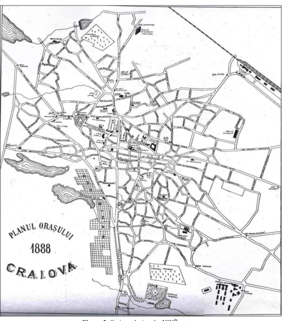
In the period following the half of the XIXth century, the city traverses a continuous development, thickening in a more rapid pace in the center and slower in the periphery. Its territorial expansion heads to the south, also sending residential and commercial strings towards its eastern and northern parts, but less towards the floodable area situated in the west. This represents the stage of most important transformations of the local, archaic reality, from the oriental, semi-rural borough towards the modern city.
Figure 2. Craiova during the second half of the XIXth century. Samitca plan, 1887 (Source: Ciobotea et al., 1999)
In general, the town was quite rarely populated, the barrens being often met within the perimeter. This perioad marks the beginning of a more compacted pattern of the urban space and the constitution of modern urban structures. The higher rarefaction of the households within the periphery indicates a certain physiognomical and functional rurality that persisted over the settlement, therefore a considerable per cent of agricultural activities (figure 3).
The spatial growth is augmenting and the demographical plus is due to the input of rural population, coming from the villages of the county after the law of 1864; another demographical sourse is represented by the emigration of Bulgarians, Serbs, Greeks, Macedonian, Jews, coming from southwards the Danube and searching for refuge on the Romanian territory where they constituted entire slums, because of the bad treatment from the Turks.
Despite the registered progress, the local industry remained in a manufactured phase, capitalizing the agricultural products of the surrounding area, the alimentary industry being best valorized at the end of the XIXth century.
Figure 3. Craiova during the XIXth century (Source: Georgescu et al., 1977)
Unlike the previous period, the territorial expansion was less made by areas of secondary dispersion and more frequently by juxtaposing new buildings and households to the area that already existed; thus, there was a double tendency: a growing compactness of the hearthland and a proximity, step-by-step extension.
In what concerns the urbanistic point of view, the settlement had a chaotic aspect, almost everything being built at random, with no holistic or unitary perspective, without respecting a regime of street alignment or broadness of the arteries. The historical process of marking the street network was gradual and arbitrary, anfractuous, conditioned by the terrain, by the archaic communication arteries, the way properties were aligned or simply, as requested by the necessities of the locals. Until the end of the XIXth century, the works implying modernisation in infrastructure strictly targeted the central area of the city.
Also, a stringent lack of elementary public services was characteristic for the entire city because of insufficient capital: pavement, security, sanitation, illuminants, water supply, sewerage; the marginal slums offered the most discouraging view.
In the years following 1848, in the context of the necessities imposed by the demographical and territorial growth, the polarizing center of the province aims at improving its medieval condition in which the city languished for too long. The first sistematization plan dates back in 1855, when streets were named, households were given numbers and the center of the settlement was fixed at the junction of the road coming from Bucovăţ barrier, crossing the city until the Bucureşti barrier with the road coming from Amaradia barrier and crossed the city towards the south. The two streets divided the settlement into four main neighbourhoods. Later, at the end of the XIXth century, architects imposed the lining of the frontage and a poligonal form of the street network.
Analysing the maps reflecting Craiova during this period, we can also observe the tendency of the habitation to spread up to the streets calls barriers: Amaradiei and Vâlcea Barrier in the north, Brestei and Bucovăţului Barrier in the west, Calafatului in the south, Caracal, Crucea de Piatră, Bucureşti in the east and south-east. In the western part of the settlement, very extended vegetable gardens, orchards and vineyards still persisted, on the territory of nowadays Craioviţa Nouă, Brestei, Lascăr Catargiu neighbourhoods. Another critical problem of functional urbanism was solved when establishing graveyards at the fringe of the city: Sineasca in the north, Dorobănţia, Catolic and Israelit in the west, Ungureni in the south, following the decision to abolish the cemeteries in the churchyards (figure 4).
Also, the construction of the railway Bucureşti-Piteşti-Turnu Severin in 1875 and the placement of the railway station 1 km north from the settlement determined the extension of housing towards the north, on a large area previously occupied by agricultural fields; in the south, the construction of Jitianu bridge over the Jiu river allowed the connection between Craiova and Calafat. Improvement regarding infrastructure occured the following years: radial arteries in order to link the center with the barriers, altogether with a main street (Calea Bucureşti) which had a double tram line, the necessary space for both ways traffic and a circular beltway, which constituted the limit for the peripheries of the XXth century: Bulevardul de centură N.P. Romanescu, today Bulevardul 1 Mai (south-west) and Şoseaua Gherceştilor, Drumul Gangului, today Rocada (north).
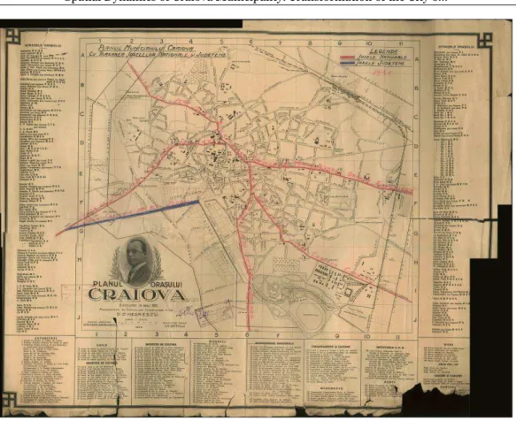
Figure 4. Craiova in 1926 by C. Negrescu (Source: Direcţia Judeţeană Dolj a Arhivelor Naţionale)
In the same time, documents make reference to an expansion of illegal buildings, appeared without approbation, improvised and insalubrious, beyond the city’s barriers. On this line, the proposal of the architects to create a neutral zone by setting a 200-300 m wide plantation in order to prevent such illegal sprawl was salutary, but unregarded. Highlighting the indiscipline in the sector, the documents attest that after 1903, when the barriers were abolished, because the administration hadn’t afforested the neutral zone, „we are facing today the settling of a new town in this area, with narrow streets and constructions as insanitary as can be”. The administrative surface was appreciated as being extensive for a population of about 45 000-50 000 inhabitants, possessing too large greenfields, unutiliyed areas or cultivated with grains.
The first topographical achievement in 1887 is related to adjusting the limited possibilities of the western and south-western parts of the settlement to be made available by fundamenting the further studies regarding their drainage. G. Savopol maps the entire area of swamps and marshes comprised between Corniţoiu valley, Obedeanu Fountain, Cernele, Albeşti, the Jiu riverbed and Balta Verde village, the Old Fountain in Popova, Chintescului Fountain and Bibescu garden moor (nowadays the Botanical Garden). The most important urbanistic workings have been the water supply system from an exogenous area, Gioroc source (1888-1911) and the sewerage system, starting with 1914, representing both an improvement of the hygiene, but also to give back to agriculture previous paludal areas.
An important spatial reference point of this period, which redimensioned the surface of the settlement is represented by the Royal Decree no. 3924, dated 1925, when Craiova had 1,727 hectares and 95 hectares were comprised in the suburban communes of that time: Bariera Vâlcii, Bordeiul, Craioviţa, Gherceştii Noi, Lascăr Catargiu, Popoveni şi Mofleni. Just like in the previous stages, the city advances towards the periphery almost exclusively on account of the residential-agricultural area.
d) The communist period, comprised between 1945 and 1989
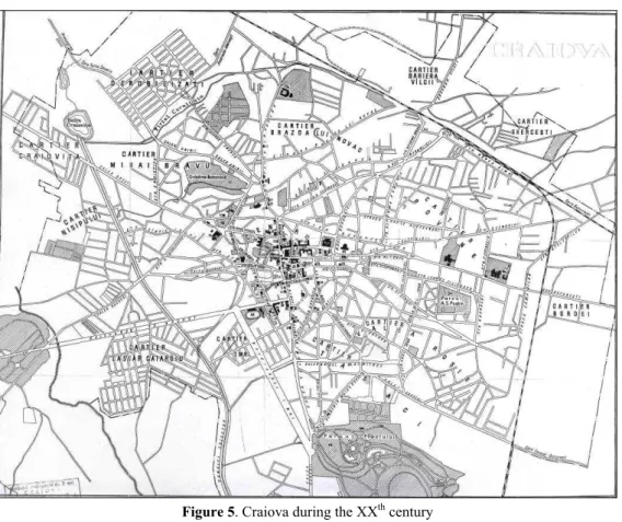
After World War Second, the settlement acquires a lenticular form, elongated on a west-east direction; this morphology is firstly marked by the influence of the Jiu river in the south and then by the impact of the railway in the north, which had a tangential position at the time and determined an extension of the built-up area towards the north.
This represents a period characterised by profound transformations, in what concerns the relation between urban space-rural adjacent area, but also in reconfiguring the interior. Craiova gets from tle old slums to the urban assimilation phenomenon by including the nearby villages in its administrative perimeter. The intense development, both on a horizontal and a vertical plan determined the agglutination of the nearby villages, as it is the case for Bordei-Hanu Doctorului area in the east or Bariera Vâlcii-Şimnicu de Jos în nord (figure 5).
Figure 5. Craiova during the XXth century (Source: Victor, 1968)
of allogene coming to work in the industrial sector of Craiova, who also transferred a typical rural demographical behaviour to the urban environment, characterized by higher fertility.
The territorial expansion was made by the industrial units of larger size, placed at the periphery of the city in the east or even in the rural area in the west, aloof from the city proper; this localization was meant to use the larger available space and the adjacency of the Jiu river. During the 6th and the 7th decennies of the XXth century, most of the industrial units went into service: „Electroputere", „7 Noiembrie”, „Oltenia” sugar and oil complex in Podari, chemical industry complex of Işalniţa, precast materials complex of Cernele, Bucovăţ-Mofleni industrial area.
Remodelling the built-up space also had a qualitative dimension that took place by building apartment blocks units and changing the physiognomy of the residential quarters situated on the medium and high terraces of the Jiu river: Craioviţa Nouă, Severinului, Brestei, Rovine, Brazda lui Novac, 1 Mai, Valea Roşie, Lăpuş-Argeş, Sărari, Calea Bucureşti, Severinului. The street network of these neighbourhoods denotes their genesis and their novelty by displaying a more organized, rectangular morphology. Herewith, the old periphery of the city from the end of the XIXth century was reorganized and appears as a belt of residential function, occupying an intermediate position, interposed between the center and the industrialized periphery. The characteristic of this period is the spatial development near the old barriers, consummating the interjacent area situated near the old circular belts (figure 6).
Although Poenari and Bariera Vâlcii villages, Bordei, Gherceştii Noi, Romaneşti will be agglutinated and included in the administrative perimeter of the city by the census of 1956, nevertheless, we can ascertain that the communist spatial development period is rather associated with the raising compactness and density of the urban space than with urban sprawl.
e) The post-communist period, after 1990
In the years following the 1989 revolution, a new profound restructuring of the center-periphery dichotomy takes place, through the consequences imposed by the agricultural real estate zoning law of 1991, the pronounced social dynamism, the proliferation of the automobile, economic structural changes and estate profiteers.
At a spatial level, we can first of all ascertain the remanent position of the industrial platform situated in the south-eatern part of the city, previously built at the periphery and englobed after 1990 by the urban tissue, surpassing a permanent growth and reorganization towards the exterior and invoking once again the conversion of the industrial space because new residential quarters were built around it.
Although the indices prove an obvious demographical decline and a perpetual ageing, still, the surface of the city evidently prospered by formally including a series of contiguous settlements within the administrative perimeter, increasing the surface in an artificial manner. Artificial because the anachronism of these suburban communes places them incorrecly from a statutory point of view for the moment. This is the case of Făcăi, Mofleni, Popoveni, Şimnicu de Jos, Cernele, Cernele de Sus, Izvoru Rece, Rovine.
On the other hand, a spillover of the urban activities can be observed unto the rural, which complicates even more the relation center-periphery in the contemporary city. The increase in the city’s dimensions and the social mobility favoured the secondary extensive commercial areas, situated close to the newest neighbourhoods and major communication arteries, assuring the supplies for their population. The tertiary activities located in the south-east of the city outline, in Cârcea (Ford, Selgros, Dedeman, Pelendava Penitenciary) and in the east, in Pieleşti (Craiova airport, Metro). The latter also emphasize Craiova’s current spatial tendencies of development, especially as tentacular strips situated along E574 and E70, as a result of the available space and accessible land prices.
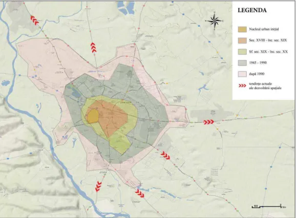
CONCLUSIONS
Nowadays Craiova originates in the spontaneous development of rural settlements of medieval times, situated nearby or on the very territory of the ancient Dacian-Roman ruins. The urban territorial growth represents the result of both spontaneous development and controlled urbanism, the latter being influenced by the centrally-planned economy and the voluntarist intervention over space typical to communism. The urban structure transformed hastily, especially during the modern and contemporary periods, from a rather simple, primitive, spontaneous, irregular and predominantly residential morphology, to a modern one, quite clearly differentiated functionally. The case study of Craiova reflects an example of a transitional status of development, a slow adaptation to modern urban structures and zoning, but also an incipient stage in urban sprawl.
REFERENCES
Avram S. (2010), Historical urban development of Craiova city between 1820 and 1990, Geographica Timisiensis, vol. 19, no. 1, p. 173-188.
Buce-Răduţ Magda (2008), Trecutul în Craiova de astăzi, Editura Sim Art, Craiova.
Bugă D. (2005), Oraşele dintre Carpaţi şi Dunăre în secolele XIX şi XX. Repartiţie teritorialăşi evoluţie demografică, Ed. Semne, Bucureşti.
Ciobotea D., Zarzără I., Pleniceanu V., Luckacs S., Avram C., Nicolaescu L. (1997), Craiova-Pagini de istorie şi civilizaţie, vol I. Alimentarea cu apă, Editura Aius, Craiova.
Ciobotea D., Zarzără I., Avram C., Bădescu I., Pleniceanu V., Luckacs S. (1999), Craiova-Pagini de istorie şi civilizaţie, vol VI: Grădinile şi parcurile Craiovei, Editura de Sud, Craiova.
Croitoru G. (2004), Evoluţia edilitar-urbanistică a oraşului Craiova reflectată în cartografia secolului al XIX-lea, Arhivele Olteniei, nr. 18, pag. 95-112.
Deaconu L. (1981), Memoria Craiovei. Itinerarii istorice, Muzeul Olteniei, Craiova.
Deaconu L., Gherghe Otilia (2000), Craiova 1859-1878. De la Alexandru Ioan Cuza la Carol I, Editura Sitech, Craiova. Deaconu L., Gherghe Otilia (2001), Craiova şi cucerirea independenţei de stat 1877-1878, Editura Sitech, Craiova. Deaconu L. (2001), Craiova 1898-1916. Saltul la urbanismul modern. Nicolae P. Romanescu, Editura Sitech, Craiova. Georgescu A. (1936), Craiova. Cercetări istorice. Târgul Craiovei, Editura „Ramuri”, Craiova.
Georgescu T., Bărbăcioiu C., Firan F. (1977), Istoria Craiovei, Editura Scrisul Românesc, Craiova. Giubelan I. (coord.), (1964), Oraşele Olteniei, Comitetul Regional pentru Culturăşi Artă, Craiova.
Ianoş I. (2004), Dinamica urbană. Aplicaţii la oraşul şi sistemul urban românesc, Editura Tehnică, Bucureşti.
Iordan I., Oancea D., Deică P. (1969), Caracterele geografice ale zonei preorăşeneşti a Craiovei, Lucrări de geografie aplicată, Institutul de Geologie-Geografie al Academiei Republicii Socialiste România, Bucureşti, pag. 142-166. Iorga N. (1972), România cum era până la 1918, vol. I „România munteană”, Editura Minerva, Bucureşti.
Marinescu I. (2006), Disfuncţionalităţile mediului urban. Studiu de caz-Craiova, Editura Universitaria, Craiova. Mihăilescu V. (2003), Evoluţia geografică a unui oraş. Bucureşti, Editura Paideia, Bucureşti.
Mitroi Mirela (2002), Zona periurbană a municipiului Craiova, Editura Universitaria, Craiova. Nicolae I. (2002), Suburbanismul ca fenomen geografic în România, Editura Meronia, Bucureşti.
Poncea T.V. (1999), Geneza oraşului medieval românesc extra-carpatic. Secolele X-XIV, Editura Biblioteca Bucureştilor, Bucureşti.
Stoenescu A.M. (2011), Istoria Olteniei, Editura Rao, Bucureşti.
Şoşea (Mara) Cristina (2010), Historical landmarks regarding the spatial evolution of Craiova municipality, Analele Universităţii din Craiova. Seria Geografie, vol. 13 (Serie nouă), p. 125-135.
Toşa-Turdeanu Ana (1975), Oltenia. Geografie istorică în hărţile secolului XVIII, Editura Scrisul Românesc, Craiova. Tudor D. (1968), Oraşe, târguri şi sate în Dacia romană, Editura Ştiinţifică, Bucureşti, 1968.
Victor A. (1968), Craiova, Editura Meridiane, Bucureşti.
*** (1984), Geografia României, vol. II, Geografia umanăşi economică, Edit. Academiei, Bucureşti.
*** (1996), România. Atlasul istorico-geografic, Academia Română, Institutul de Geografie, Edit. Academiei Române, Bucureşti.
*** (2005), Dicţionarul istoric al localităţilor din judeţul Dolj. Craiova, Academia Română, Institutul de Cercetări Socio-Umane „C.S. Nicolăescu Plopşor”, Editura Alma, Craiova.
*** (2004), Dicţionarul istoric al localităţilor din judeţul Dolj. A-C, D-M, N-V, Academia Română, Institutul de Cercetări Socio-Umane „C.S. Nicolăescu Plopşor”, Editura Alma, Craiova.
Submitted: Revised: Accepted and published online