GKB - Geographic Knowledge
Base
Marcirio Silveira Chaves, M´
ario J. Silva
and Bruno Martins
DI–FCUL
TR–05–12
July 2005
Departamento de Inform´
atica
Faculdade de Ciˆ
encias da Universidade de Lisboa
Campo Grande, 1749–016 Lisboa
Portugal
Contents
1 Introduction 1
1.1 Context and Requirements of GKB . . . 2
2 Related Work 4 2.1 Structures to Represent Knowledge . . . 4
2.2 Geographic Knowledge Representation . . . 5
3 Conceptual Design of GKB 6 3.1 Features and the Meta-model . . . 6
3.2 Feature Types Dependencies . . . 7
4 Instance of Portugal 8 4.1 Information Sources . . . 11
4.1.1 Geo-administrative Domain . . . 12
4.1.2 Network Domain . . . 12
4.2 Loading Procedure . . . 13
4.2.1 Geo-administrative Domain . . . 13
4.2.2 Network Domain . . . 13
4.3 Descriptive Statistics . . . 14
4.3.1 Geo-administrative Domain . . . 14
4.3.2 Network Domain . . . 15
5 Instance of the World 16 5.1 Information Sources . . . 18
5.2 Loading Procedure . . . 18
5.3 Descriptive Statistics . . . 18
6 Data Quality and Information Integration Issues 20 6.1 Single-source Problems . . . 21
6.1.1 Spelling Errors Correction . . . 21
6.1.2 Postal Codes Validation and Correction . . . 21
6.1.3 Insertion of Alternative Names . . . 22
6.1.4 Correction of Geographic Coordinates . . . 22
6.2 Multi-source Problems . . . 22
6.2.1 Matching between Data from POS:CTT and GEO:GAZ . . . 22
6.2.2 Inconsistences between Information Sources and Web Data . . . 23
6.3 Data Normalisation . . . 23
6.4 Semantic Integration . . . 24
7 Representing Geographic Knowledge in GKB 25 8 GKB as an Ontology 27 8.1 Declaring the Vocabularies to Be Used in the Geographic Ontology . . . 28
8.2 GOG - GKB Ontology Generator . . . 28
9 Applications using GKB 31
List of Tables
1 Distinct values from ADM:INE . . . 14
2 Distinct values from POS:CTT . . . 14
3 Number of municipalitiesbydistrito . . . 15
4 Population bymunicipality . . . 16
5 Descriptive statistics of the Geographic Ontology of Portugal . . . 16
6 NET:FCCN Statistics . . . 16
7 Descriptive statistics of the Geographic Ontology of the World . . . 19
8 Examples of spelling errors . . . 21
9 Inconsistences in postal code from network domains database . . . 21
10 Coordinates to the region ofVila Nova atdistrito ofViseu . . . 22
11 Types of geographic features . . . 23
12 Inconsistences between information sources and Web data . . . 23
List of Figures
1 Context of GKB . . . 2
2 Requirements of GKB . . . 3
3 GKB information architecture . . . 6
4 GKB information meta-model . . . 7
5 Feature types dependencies for the geo-administrative domain of GKB (instance of the World) . . . 7
6 Feature types dependencies for the geo-physical domain of GKB (instance of the World) . . . 8
7 Feature types between the geographic domains . . . 9
8 Geographic domain data model . . . 9
9 Network domain data model . . . 10
10 Inter-domain relationships data model . . . 10
11 Full data model of GKB (instance of Portugal) . . . 11
12 Full data model of GKB (instance of the World) . . . 17
13 Components of GKB . . . 20
14 Data quality problems classification [Rahm and Do, 2000] . . . 20
15 Feature types dependencies in two information sources of the GKB instance of Portugal . . . 25
16 Merged GKB hierarchy . . . 25
17 Graphical representation of the feature types dependencies in the geo-administrative domain of the GKB instance of Portugal . . . 26
18 ABox in DLs for the city of “Santiago do Cac´em” (the numeric values 270 and 33684 correspond to the feature identifier in an instance of GKB holding these data) 27 19 An excerpt of GKB-extracted ontology with data about Portugal . . . 29
20 An excerpt of an ontology extracted from GKB repository with World data . . . 30
GKB - Geographic Knowledge Base
Marcirio Silveira Chaves, M´
ario J. Silva and Bruno Martins
Department of Informatics
Faculty of Sciences - University of Lisbon
1749-016 Lisbon, Portugal
July 2005
Abstract
This paper introduces GKB, a repository based on a domain-independent meta-model for integrating geographic knowledge collected from multiple sources. We present the architecture, the repository design and the data cleaning and knowledge integration processes. We also describe the rules developed to add new knowledge to the repository. GKB includes tools for generating ontologies, which are being used by multiple Semantic Web applications. In addition GKB supports multiple languages. To illustrate how it is being used, we describe some applications that interact with the repository or load the generated ontologies.
1
Introduction
The vision of the Semantic Web is a distributed system for knowledge representation and computing. However, a barrier to its success is the need for annotated resources in a standardised machine understandable format. For instance, the natural language sentence “Lisbon is the capital of Portugal” should be annotated with a formal representation of it, e.g. Lisbon can be annotated as “city”, Portugal as “country”, and the sentence should be annotated through a structure “related-to(sentence, Lisbon); part-of(Lisbon, Portugal)”.
In this context, a knowledge base (KB) has a key role in supporting applications such as Text Mining, Information Retrieval and Natural Language Processing. An interesting text mining problem concerns the fact that many information resources on the Web are primarily relevant to geographically limited communities. Finding automatic ways of assigning geographical scopes to these resources (“geo-referencing” Web documents) is a challenging problem, getting increasing attention from text mining researchers [Manov et al., 2003, Purves and Jones, 2004]. A geographic knowledge base provides support for query disambiguation, query term expansion, relevance ranking, document annotation, and reasoning about geographical concepts.
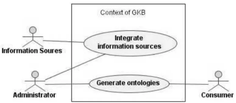
Figure 1: Context of GKB
data are then used by several applications that require geographic knowledge. We represent the geographic and network knowledge in Description Logics (DL) [Baader et al., 2003], which allows us expanding the knowledge ever stored. DL is the formalism under the languages used in Semantic Web.
Most geographic information stored electronically is still embedded in legacy databases and file storage formats that were not designed to interact easily with other software. One of the contributions of this work is provide information in a machine readable format in the context of Semantic Web [Berners-Lee et al., 2001]. So, the development of tools to transfer this information for a Web suitable format is a requirement. We are concerned about two of the main challenges dealing with ontologies: their creation and management. Design, development, storage and maintenance are discussed in this paper.
GKB is implemented on top of a relational database, which maintains the consolidated information collected from various information sources. In addition to the database, GKB has two sets of tools:
• converters, which load data from the various source formats into GKB. These tools perform some amount of data normalisation in order to maintain a single unified view of all the information. Converters to this same task are also used in [Hill, 2000];
• generators, which output the GKB contents as ontologies. The generated ontologies are represented in the OWL (Web Ontology Language) standard [McGuinness and van Harmelen, 2004], suitable to be used by other components of the GREASE project.
The ontologies generated are mainly used for Information Retrieval and Information Extraction. Other components developed in the GREASE project such as CAGE (acronym to CApturing Geographic Entities - a geographic entity names recogniser) and Geo-Tumba (a geographic search engine) use the information in GKB. These modules will be latter introduced in Section 9. We intend to augment the knowledge present in this repository by exploring the semantic relations among the geographic entities described in the texts of the Portuguese Web. The search by complex semantic relationships between semantically annotated entities is the next step of the Semantic Web [Sheth et al., 2004].
1.1
Context and Requirements of GKB
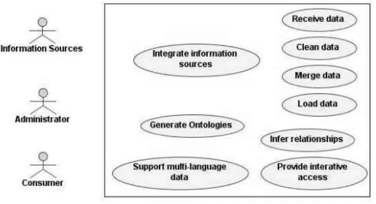
Figure 2: Requirements of GKB
Sources and Generate Ontologies. An Administrator is responsible for managing GKB. Ontologies are produced forConsumers, which include tools and software systems such as CAGE and Geo-Tumba.
Figure 2 shows the requirements of GKB. In detail, these are:
Integrate information sources: GKB must support the addition of data from many information sources and different suppliers quickly. Some of the sources update information frequently. Public administration reorganisation or the creation of new urban areas are examples of events that trigger updates to information present in GKB.
Receive data: The administrator receives data in text format and studies its characteristics. Based on this preliminary analysis, he implements cleaning scripts to import the information source data into the GKB.
Clean data: A rigorous process before the insertion of data into GKB is the cleaning of the imported data, which usually has distinct formats and can be replicated. After the administrator receives the data, he modifies the existing scripts or creates new ones to clean these data. This process includes the resolution of inconsistencies in received data.
Merge data: Some of the information sources have data in common. The administrator should identify these cases and implement scripts to merge the data before the loading phase. This use case help us to avoid inserting duplicate data in GKB.
Load data: The data from an information source, which may have previously been merged with other sources is added to the data in the GKB.
Infer relationships: Inferences can be performed when the same data is associated with different entities. For example, postal codes are present both in geographic and network domains. The administrator runs programs that add relationships between GKB entities derived from the implicit knowledge about these information domains.
Generate ontologies: The administrator creates the ontologies to the consumers.
Support multi-language data: GKB stores multi-language data. It should support this kind of characteristic to allow users and applications to choose the assignation of geographic names in a specific language or all of them.
The remainder of this paper is organised as follows: the next Section discusses related works. Section 3 presents the information domains and the conceptual design of GKB. GKB is instanced with Portugal and World data, which are described in Sections 4 and 5, respectively. Section 6 discusses the data quality and information integration issues. Section 7 presents rules in DL used to expand the knowledge in GKB. Section 8 describes GKB as an ontology. Section 9 introduces the applications using GKB. Finally, Section 10 presents the final conclusions and some ideas to future work.
2
Related Work
We split this section in structures to represent knowledge and geographic knowledge representation. In the former, we introduce the main concepts used in our work. In the latter, we present some of the works that deal with geographic knowledge representation.
2.1
Structures to Represent Knowledge
Frequently, concepts like gazetteer, ontology and thesaurus are used indistinctly. We present our understanding about them in the following.
A simple definition to gazetteer can be found in WordNet (http://www.cogsci.princeton. edu/): a geographical dictionary. Wikipedia (http://en.wikipedia.org/wiki/Gazetteer) extends this definition asserting that a gazetteer typically contains information concerning the geographic makeup of a country or region, and the social statistics. We add that often a gazetteer includes information about latitude and longitude coordinates.
The most used definition of an ontology is given by Gruber: an ontology is an explicit specification of a conceptualisation [Gruber, 1993]. Fensel details this definition, asserting that a conceptualisation refers to an abstract model of some phenomenon in the world, which identify relevant concepts from that phenomenon [Fensel, 2001]. A conceptualisation explains the intended meaning of the terms used to indicate relevant relations [Guarino, 1997]. The restriction to be explicit means that the concepts and relations between them are explicitly defined, that is, there is no ambiguity in the ontology.
Gonzalez discusses more than 15 definitions of a thesaurus [Gonzalez, 2001]. According to him, a thesaurus is a lexical database that implements an ontology, where the described terms should be interpreted as concepts and its relationships constitute the essence of the description of these concepts. A thesaurus is a closed language restricted normally by three relationships, which are: equivalence (Used For and USE), hierarchy (Broader Term/Narrower Term) and associativity (Related Term) [ISO2788, 1986].
According to the definitions of a gazetteer, it is a flat structure, which does not contain explicit relationships between the terms. On the contrary, with an ontology, we capture and formalise the main concepts and their relationships in a knowledge domain (in our case, the geographic one). We can use an open language to build an ontology, without restrictions about kinds of relationships as in a thesaurus.
2.2
Geographic Knowledge Representation
Geographic knowledge bases have been used lately to support research in Information Retrieval and Geographical Information Management [Inoue et al., 2002, Jones et al., 2003, Fu et al., 2003, Gravano et al., 2003, Markowetz et al., 2004].
Manov et al. worked in the creation of a structured knowledge base according to an ontology, instead of having flat structures of gazetteer lists [Manov et al., 2003]. Irie and Sundheim built an integrated geospatial database of place names information from four distinct gazetteers [Irie and Sundheim, 2004]. In our approach, instead of obtaining data only from gazetteers, we also import data from other classes of information sources. We followed a similar approach to Alani et al., relying on a generic meta-model, implemented as a relational database [Alani et al., 2003]. From the information gathered in this database, we generate ontologies to semantic Web applications. The use of ontology(ies) to represent the content expressed in documents or databases has been presented in several works [Mena, 1998, Kietz et al., 2000, Nob´ecourt, 2000, Cruz et al., 2002, Szulman et al., 2002, Hyv¨onen et al., 2004, Purves and Jones, 2004].
The main aims identified to use ontology(ies) to represent knowledge are:
• to aid tasks such as search disambiguation, expansion of terms in the search, sort of relevance and annotation of the Web resources [Fu et al., 2003].
• to create a structured KB instead of having this base according to somewhat flat structures of gazetteer lists [Manov et al., 2003].
Spatially-Aware Information Retrieval on the Internet (SPIRIT) is a European project which aim is use ontologies to aid task such as query disambiguation, query term expansion, ranking and annotation of Web resources [Fu et al., 2003]. The main characteristic of this system is the production of ways to facilitate and support queries using terms and geographic relations.
An immediate question that arises when we mention geographic systems is the use of gazetteers. Fu, Abdelmoty and Jones consider problems with their use such as the lack of sufficient support to explicitly code spatial relationships (overlap and adjacency, for example) and use of geographic attributes of different kinds coded in the same way [Fu et al., 2003]. In order to deal with these and other problems, SPIRIT uses a geographic ontology represented in the DAML+OIL language.
Gravano, Hatzivassiloglou and Lichtenstein classify queries according to the geographical localities [Gravano et al., 2003]. Specifically, a query can belong to one of the two categories: global or local. A query is considered local when it is composed by a geographic term, otherwise it is global. A database of 1,605 names of the main locations in USA was used in order to help the identification of the geographic scope of the query. A deficiency in their classification is the lack of a phase of disambiguation of terms. A document where the termWashington occurs is classified as located in the city ofWashington, independently of this term referring to a name of a person.
Figure 3: GKB information architecture
associative relationships. The structure and data of GKB is similar to TGN. However, we focus on Portuguese data and our resource is public and freely available.
3
Conceptual Design of GKB
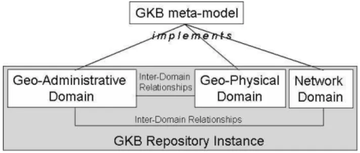
Figure 3 shows the information architecture of GKB. Data is organised in information domains, each representing a set of related geographic features. There are presently three domains defined in GKB: geo-administrative, geo-physical and network. The information in each domain is structured identically, as they all implement a common meta-model.
Ontological relationships among the features of each domain are also described in both repositories. For instance, for the geographic domain, GKB essentially provides a hierarchical naming scheme with transitive “sub region of” and name alias capabilities. Tudhope et. al. listed the three main thesaurus relationships: i) equivalence (equivalent terms), ii) hierarchical (broader and narrower terms), and iii) associative (related terms) [Tudhope et al., 2001]. GKB provides these three types of relationships among geographic features, specialising the associative relationship into generically associated and geographical adjacency. In addition, GKB also supports inter-domain relationships, which are associations between entities from different information domains. For example, we represent the geographic scope of a Web site as a relationship between the Web site (a network domain entity) and a geographic region (a geographic domain entity).
3.1
Features and the Meta-model
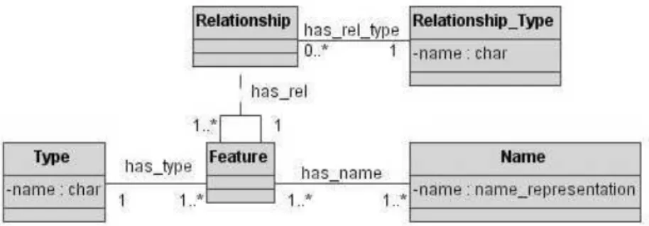
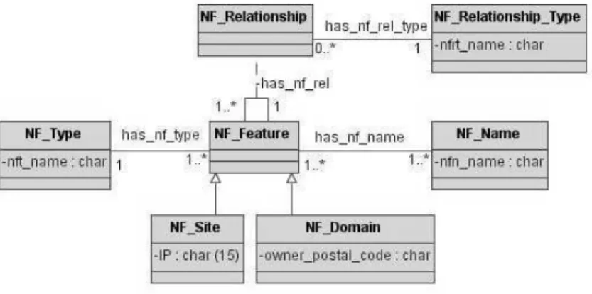
In GKB, we distinguish the name and the feature (or entity) that it represents. We use the notion of feature defined in ISO 19109, “a meaningful object in the selected domain of discourse” [ISO19109, 2005]. In the geographic domain, countries, cities and municipalities are examples of such objects. In GKB, features and their names are distinct classes and each feature is associated to a feature type. As in ISO 19109, features are classified into feature types on the basis of common sets of characteristics or properties. This approach enables GKB to support many-to-one relationships between names and features. This flexibility also allows the incorporation of new kinds of data. The GKB meta-model is sufficiently generic to represent information from any domain.
Figure 4: GKB information meta-model
Figure 5: Feature types dependencies for the geo-administrative domain of GKB (instance of the World)
all available information sources. Finally, the classesRelationshipandRelationship Typecapture relationships among features.
We have developed two GKB instances: one stores data about the geo-administrative and network domains of Portugal and another with geo-administrative and geo-physical data about the World. For Portugal, we have more detailed information, including the main administrative regions (names of streets, for example) and their geographic coordinates. The network domain has information about DNS (Domain Name Service) domains hosting Web sites of the Portuguese Web. The second repository stores data about the geographic domain, which is split in administrative and physical.
3.2
Feature Types Dependencies
For each GKB instance, we define a set of feature types and relationship types. In the integration process, we use the implicit knowledge about the dependencies between the feature types defined for each instance. Figure 5 presents these dependencies for the geo-administrative domain, which was the first loaded in GKB with World data.
Figure 6: Feature types dependencies for the geo-physical domain of GKB (instance of the World)
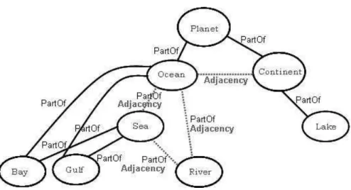
We model the dependencies between feature types in the geo-physical domain as represented in Figure 6. The upper feature type isPlanet, which is composed by OceansandContinents. These have a adjacency relationship between them. Ocean is related to the feature types Sea andRiver. Both them are part of or adjacent to Ocean. River can be also part of or adjacent toSea. BayandGulfcan be part of both,Seaor Ocean. Finally,Lake is part of Continent.
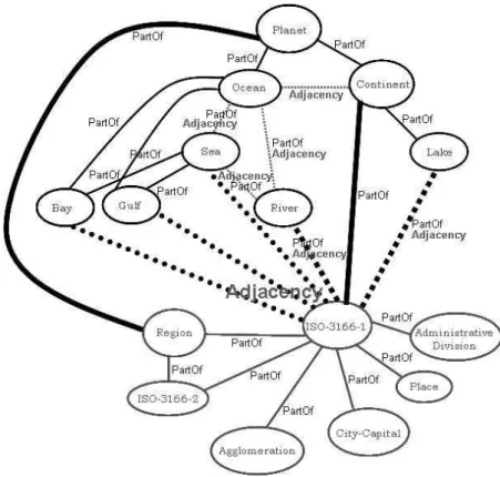
In addition to the dependencies above, there are also dependencies between feature types of distinct domains. Figure 7 shows the dependencies between the administrative and geo-physical domains.
The geo-administrative domain is related to the geo-physical domain through the feature typesISO-3166-1andRegion. An instance of anISO-3166-1can be part of River,Continent orLake. It may be adjacent toBay,Gulf,Sea,RiverorLake. An instance of aRegioncan be part of aPlanet, in our caseEarth.
4
Instance of Portugal
The model of the geographic domain for GKB instance of Portugal is represented in Figure 8. The classes GF Type, GF Feature, GF Relationship, GF Name and GF Relationship Type represent the same classes of the base meta-model presented in Figure 4. The geographic feature types include municipalities, streets and postal codes. The geographic relationship types are defined aspart ofandadjacency. Geographic features are specialised when we need to capture detailed administrative data, such as population of some regions or geographic coordinates, such as latitude and longitude. The classesGF Feature Populated and GF Feature Footprint are specialisations of the classGF Feature. TheGF Nameclass stores alternative names (names often used with the same meaning of the standard name). For instance, the geo-administrative region ofNossa Senhora da Concei¸c˜aoinLisboais also referenced with the alternative nameConcei¸c˜ao. This alternative name is associated with the standard name in GF Feature, once it is identified with the same identifier of the standard name. Alternative names have also been considered in other works [Jones et al., 2003, Hill, 2000].
Figure 7: Feature types between the geographic domains
Figure 8: Geographic domain data model
stores the Web domain owners’ postal code. We use postal codes to associate features between geographic and network domains.
Figure 9: Network domain data model
Figure 10: Inter-domain relationships data model
GKB has just two domains, which are inter-related through the data in common. However, we intend to expand GKB to allow the definition of relationships between features from different domains. So, we need to provide a generic and extensible model to support inter-domain relationships, which is presented in Figure 10. The classID Relationshipstores the relationships between the features of the inter-related domains. In GKB, we define a relationship between features in the network and geographic domains.
In the GREASE project, our goal is to assign geographic scopes to Web pages. In GKB, a scope is modeled as an inter-domain relationship between a Web domain and a geographic feature. For instance, the geographic scope of the Web site of the Lisbon municipality,www.cm-lisboa.pt, is the city of Lisbon.
Figure 11 presents the full data model for the GKB instance of Portugal. The only class still not previously explained isInfo Source, which stores both the name of the sources and the date that it was inserted into GKB. Info Source allows us to version data loaded into GKB over time. Each feature and relationship inserted into GKB is associated to one single information source.
Figure 11: Full data model of GKB (instance of Portugal)
4.1
Information Sources
4.1.1 Geo-administrative Domain
Detailed information must be collected from several classes of information sources. Examples of classes include administrative (statistical), postal, administrative, religious and judicial. This section characterises the information sources presently providing geo-administrative information to GKB.
Administrative (ADM:INE): Databases from the Instituto Nacional de Estat´ıstica (INE) concerning demographics and administrative information, such as the territorial division. The INE’s administrative classification is mandatary being split by Nomenclature of Territorial Units (NUT). NUT1 (all national territory), NUT2 (Norte, Centro, Lisboa e Vale do Tejo, Alentejo and Algarve more Regi˜ao Aut´onoma da Madeira and Regi˜ao Aut´onoma dos A¸cores), NUT3 (subregions of NUT2), NUT4 (subregions of NUT3). In addition ANMP (Associa¸c˜ao Nacional de Munic´ıpios Portugueses) provides us the adjacency relationships among thedistritos andmunicipalities.
Postal (POS:CTT): The Portuguese Post Office (CTT) publishes a database of postal codes. From this database we get, for each postal code, the following types of administrative information: distrito, municipality, localidade andarruamento. For instance, the 2775-096 postal code identifies thearruamento Avenida Infante Dom Henrique in thelocalidade
ofMurtal in themunicipalityofCascais in the distritoofLisboa. The typearruamento
was subdivided in more specific types according to the occurrences found in POS:CTT. A full list of types present in this domain can be found in Appendix A.
Gazetteer (GEO:GAZ): Directory of cities, towns, and regions in Portugal (http://www.calle.com/world/PO/). The gazetteer provides the geographic coordinates of the main regions of Portugal. An example of instance of such gazetteer is the distrito
of Porto, region of Matosinhos with latitude 41.1833◦ N and longitude 8.7000◦ W. In
World level, this gazetteer provided us information about the names of the countries, territories and the main subregions into these countries. We follow the standard ISO-3166-1 and ISO-3166-2 (http://www.iso.org/iso/en/prods-services/iso3166ma/ 02iso-3166-code-lists/list-en1.html). The feature Bremen, which is a subregion (ISO-3166-2) intoGermany, is an example of data from GEO:GAZ.
Wikipedia (ADM:WIKI): This is an on-line encyclopedia from which we get the list of
freguesias andmunicipalities. For instance from ADM:WIKI we obtain the information that thefreguesia ofSanta Isabel belongs to themunicipalityofLisboa.
4.1.2 Network Domain
The network domain is composed by data about Web domains and Web sites which come from two information sources:
Web domains (NET:FCCN): Funda¸c˜ao para a Computa¸c˜ao Cient´ıfica Nacional (FCCN) domains database. NET:FCCN provides the domains registered under PT top level domain as well as the postal code of the registrant. An instance of NET:FCCN is
igrejacampogrande.pt, which has the2670-459 postal code.
In addition to these sources, we intend to receive information from Web users related to the new domains, scope of the new or existent domains and so on. The idea is allow the users to contribute with his knowledge, in order to improve the knowledge stored in GKB.
4.2
Loading Procedure
In this section we describe the sequence of steps taken to load the GKB instance of Portugal with data from the information sources described above.
4.2.1 Geo-administrative Domain
Loading of the geographic domain with data about Portugal involves the following steps:
1. Population of theInfo Source,GF TypeandGF Relationship Typeclasses.
2. Population of theGF NameandGF Featureclasses with administrative data, namelyNUT1, NUT2,NUT3andmunicipalities.
3. Population of theGF Relationshipclass with data fromGF Featureclass. All geographic domain relationships are stored in GF Relationship. It is composed by two feature identifiers, a type identifier of the semantic relation and the information source identifier. For example, we search the names into cleaned POS:CTT to store the relation that a municipality is part of a distrito. We search the feature identifiers of these names in GF Featureclass and store the ones found together the type identifier of semantic relation extracted from GF Relationship Typeclass intoGF Relationshipclass.
4. Population of theGF Footprintclass with data from GEO:GAZ. These data are latitudes and longitudes inserted intoGF Footprintclass. Each pair of coordinates is associated to a localidadein GF Featureclass.
5. Population of the GF Name class with alternative names from GEO:GAZ. To load these alternative names into GKB, we first verify if each of these names is not present in the GF Name class. If it is not found, we insert it in both GF Name and GF Feature classes. Subsequently, we get the feature identifiers of both the preferred name and the alternative name and store them in theGF Relationshipclass with the relation identifierequivalent extracted from GF Relationship Typeclass.
4.2.2 Network Domain
1. Population of the NF Name, NF Feature and NF Site classes with data from Web sites crawled in PT4 and PT5. The loading of this classes is described in the following:
• NF Namereceives the names of the sites.
• NF Feature class stores the identifier of each name together the net:site type identifier provide fromNF Typeclass.
• NF Siteclass receives the feature identifier (of a site, in this case) and its IP.
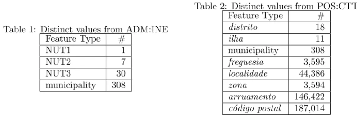
Table 1: Distinct values from ADM:INE Feature Type #
NUT1 1
NUT2 7
NUT3 30
municipality 308
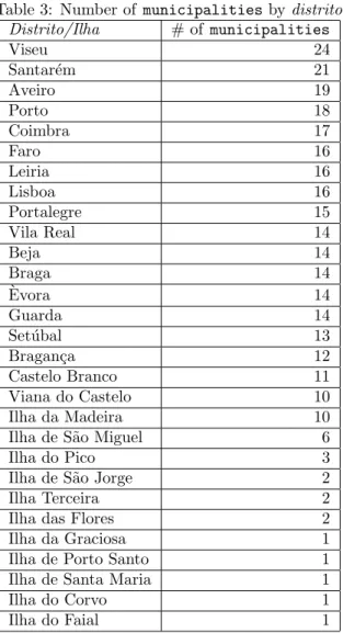
Table 2: Distinct values from POS:CTT Feature Type #
distrito 18
ilha 11
municipality 308
freguesia 3,595
localidade 44,386
zona 3,594
arruamento 146,422
c´odigo postal 187,014
4.3
Descriptive Statistics
In this section we show some of the results extracted from GKB for both domains, geographic and network. Results about the geo-administrative domain include both levels Portugal and World. These give the reader a quantitative information presently loaded in GKB.
4.3.1 Geo-administrative Domain
The results extracted from geographic domain include the data from ADM:INE, POS:CTT, ADM:WIKI and GEO:GAZ. Table 1 lists the number of features of each type provided from ADM:INE. Table 2 lists the number of features of each of the eight geographical types. It is possible to note that the number ofc´odigos postais represents more than 50% (187,014) of the 266,212 distinct names (number of registers inGF Nameclass) about Portugal inserted into GKB.
Other data included in GKB are the number of municipalitiesassociated todistritos1
. We present this information in Table 3 in decreasing order by number of municipalities.
The information about the population of each feature is used by some of the GKB applications for several purposes. For instance, one application uses the population value to disambiguate between features with identical names. Table 4 (a) presents the ten most populous municipalitiesand Table 4 (b) the ten less populous municipalitiesin Portugal according to the ADM:INE. The average of population by municipalities is 33,624 and the standard deviation is 54,870. This value of the standard deviation represents a large variation between the average and the value of the population of eachmunicipality.
Table 5 presents descriptive statistics about GKB loaded with data about Portugal. Considering the all types of features in geographic domain, except postal code, there are 198,769 distinct names of geographic entities in GKB. In average, each name in GKB is associated to 2.5 features. This fact is an evidence that there is a lot of ambiguity in the geographic domain of Portugal.
Most of the relationships (99.83%) are of the part of type, while equivalence and adjacency are less frequent, since just municipalities and localidades have equivalence relation and justmunicipalitieshaveadjacency relation.
Basically, each feature has a broader feature, while a feature has in average ten narrower features. Considering just the features with equivalents, we have about two equivalent features for each, while for the adjacent features this value increases to 3.54. For most of the features, there are no descendants, equivalent and adjacent, however just three features does not have
1Although the isles do not be considered properlydistritosin ADM:INE, POS:CTT database considers them
Table 3: Number of municipalitiesbydistrito Distrito/Ilha # of municipalities
Viseu 24
Santar´em 21
Aveiro 19
Porto 18
Coimbra 17
Faro 16
Leiria 16
Lisboa 16
Portalegre 15
Vila Real 14
Beja 14
Braga 14
`
Evora 14
Guarda 14
Set´ubal 13
Bragan¸ca 12
Castelo Branco 11
Viana do Castelo 10
Ilha da Madeira 10
Ilha de S˜ao Miguel 6
Ilha do Pico 3
Ilha de S˜ao Jorge 2
Ilha Terceira 2
Ilha das Flores 2
Ilha da Graciosa 1
Ilha de Porto Santo 1
Ilha de Santa Maria 1
Ilha do Corvo 1
Ilha do Faial 1
part of relation with other features. This fact points that most of the features have at least one relationship type connecting them.
4.3.2 Network Domain
The numbers presented in this section were extracted from NET:Versus and NET:FCCN information sources. Data provided by NET:FCCN were stored in GKB generating 39,191 domains. From these, there are 32,191 registers with at least one postal code associated under “PT” top level domain. These data are summarised in Table 6. We get to identify at least one
Table 4: Population bymunicipality a) Top ten
Municipality Population
Lisboa 564,657
Sintra 363,749
Vila Nova de Gaia 288,749
Porto 263,131
Loures 199,059
Amadora 175,872
Cascais 170,683
Matosinhos 167,026
Braga 164,192
Gondomar 164,096
b) Lower ten
Municipality Population
Corvo 425
Lajes das Flores 1,502
Barrancos 1,924
Santa Cruz das Flores 2,493
Alvito 2,688
Porto Moniz 2,927
Mour˜ao 3,230
Vila de Rei 3,354
Arronches 3,389
Monforte 3,393
Table 5: Descriptive statistics of the Geographic Ontology of Portugal
Statistic Value
Number of features 418,065
Number of distinct names different of postal codes 78,392 Number of features different of postal codes 198,769
Number of relationships 419,867
Number of part-of relationships 418,340 (99.83%) Number of equivalence relationships 395 (0.09%) Number of adjacency relationships 1,132 (0.27%)
Avg. broader features p/features 1.0016
Avg. narrower features p/features 10.5562
Avg. equivalent features p/features with equivalent 1.99 Avg. adjacent features p/features with adjacent 3.54 Number of features without ancestors 3 (0.00%) Number of features without descendants 374,349 (89.54%) Number of features without equivalent 417,867 (99.95%) Number of features without adjacent 417,739 (99.92%)
Table 6: NET:FCCN Statistics
Property Value
# of internet domains 39,191
# of Internet Domains with at least one valid postal code registered into
Portugal 32,191
# of internet domains registered outside Portugal 3,012
# of distinct postal codes from Web domains 7,062
# of distinct postal codes from POS:CTT 187,014
5
Instance of the World
Figure 12: Full data model of GKB (instance of the World)
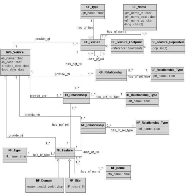
in a machine-readable way. We model two geographic domains in this instance of GKB: administrative and physical. Figure 12 presents the full data model of GKB with World data. Appendix C presents the SQL code to create relational schemas of the data models presented in this section.
Most of World data belong to the geo-administrative domain (classes with the prefix GF Pol represent this domain). To capture all the World related information required by our applications, classGF Pol Typeadds the types ISO 3166-1 (countries and territories), ISO 3166-2 (sub-entities into ISO 3166-1), city, place, agglomeration and administrative division as instances. Except for the ISO types, in this GKB instance only the geographic features with population above 100,000 people are stored. Countries and territories are usually referred both by their common (or short) name or official name. We capture this in two Boolean attributes,preferred name and official name. The GF Pol Name class stores the names of the features plus their language, which is maintained in the attributelang.
regions, while GF Feature Populated stores the population of the geographic features when available.
For the geo-physical domain, we defined the planet, continent, sea and lake. In class GF Pol Relationship, we related them. We are now introducing the names of the oceans and other geo-physical types. In class ID Relationship, we relate the administrative and geo-physical domains. All the countries and territories are related to their respective continents.
5.1
Information Sources
Gazetteer (W:GAZ): We obtain from the World gazetteer information about the largest cities and agglomerations around the world. An instance of W:GAZ is a record with information stating that the state ofRio Grande do Sul is located in Brazil, has population10,723,745
and it is classified as an administrative division.
Wikipedia (ADM:WIKI): This is the same information source used to load the Portugal instance. However, for World data, we use the names of countries and capitals in four languages. In addition, we collect all the geo-physical domain from this source. An example from this source states thatMaputo is the capital ofMozambique.
5.2
Loading Procedure
Loading of the geographic domain with World data involves the following steps:
1. Population of theInfo Source,GF Pol TypeandGF Pol Relationship Typeclasses.
2. Population of the GF Pol Name, GF Pol Feature and GF Pol Relationship classes with data about countries, territories and capitals in Portuguese, Spanish, English and German, respectively.
3. Population of the GF Pol Name, GF Pol Feature and GF Pol Relationship classes with data about ISO-3166-2, agglomeration, place and administrative division.
4. Population of theGF Phy TypeandGF Phy Relationship Typeclasses.
5. Population of the GF Phy Name, GF Phy Feature and GF Phy Relationship classes with data about planet, continents, seas and lakes.
5.3
Descriptive Statistics
Table 7: Descriptive statistics of the Geographic Ontology of the World Geographic Administrative Division
Statistic Value
Number of features ISO-3166-1 (4 languages) 239 Number of features ISO-3166-2 (in English) 3,979 Number of features Agglomeration (in English) 751
Number of features Place (in English) 3,968
Number of features Administrative Division (in English) 3,111 Number of features City-Capital (4 languages) 233
Number of features Regions (4 languages) 2
Number of features 12,283
Number of populated features 7,970 (64,88%)
Number of features from WIKI 4,453 (36,25%)
Number of features from W:GAZ 7,830 (63,75%)
Number of relationships part of 11,995
Number of relationships 11,995
Geographic Physical Division
Statistic Value
Number of features Planet (4 languages) 1
Number of features Continent (4 languages) 7
Number of features Sea (4 languages) 1
Number of features Lake (4 languages) 1
Number of features 10
Number of features from wikipedia 10 (100%)
Number of relationships part of 9
Number of relationships 9
Inter-Domain Relationships
Statistic Value
Number of relationships part of 241
Number of relationships adjacency 13
Number of relationships 254
Total
Total number of features 12,293
Total number of relationships 12,258
Number of part-of relationships 12,245 (99,89%) Number of equivalence relationships 2,501(20,40%)
Number of adjacency relationships 13 (0.10%)
Avg. broader features per feature 1.07
Avg. narrower features per feature 475.44
Figure 13: Components of GKB
Figure 14: Data quality problems classification [Rahm and Do, 2000]
6
Data Quality and Information Integration Issues
In this section, we detail the process of data conversion and cleaning as it is loaded into GKB. In addition, we describe the subsequent data normalisation process. Finally, we discuss the semantic integration of the information collected from the GKB information sources.
The data sources used by GKB are independently developed and maintained to serve specific needs, resulting in a large heterogeneity in terms of information models. Some of them complement each other by providing additional information about a geographical entity. Thus, duplicate information should be purged out and complementary information should be consolidated and merged in order to achieve a consistent view of the modeled world.
The process of data cleaning, which is essential to build a consistent KB, is abbreviately designed as ETL, after the initials of its three phases: extraction, transformation, loading [Rahm and Do, 2000]. A hard and rigorous work has to be done during this process, since the data which will be inserted into GKB comes from several sources and needs to be cleaned to eliminate inconsistences and duplicates.
ETL is carried out before data are inserted into GKB (see Figure 13). When the administrator receives the data to be inserted into GKB, he stores them into a set of files in the Comma Separated Values (CSV) format. After this, he implements some scripts or modifies those already available to perform the data cleaning. In the sequence, the data are loaded into the tables of GKB and other scripts are run to generate the domain ontologies in OWL standard.
Table 8: Examples of spelling errors ID Name of the feature 193771 bairro da cooperariva 1a
fase 193772 bairro da coopertiva 1a
fase 193773 bairro da cooperativa 1a
fase 193774 bairro da cooperativa 1o
fase
Table 9: Inconsistences in postal code from network domains database Domain postal code
mestredeaviz 1495 -148 centralfundos 1050 - 185
sos 1600162
adruse 6290–520 hotelinfantesagres
4050-belo-construcoes 1070 moviflor 199-008 esteproar 2.735.507
fetec 800
6.1
Single-source Problems
The main tasks in solving these problems include correction of the spelling errors, validation and correction of postal codes, insertion of alternative names, and correction of geographic coordinates. Some of the handled cases found while cleaning the data used to build the GKB instance of Portugal are detailed below.
6.1.1 Spelling Errors Correction
Spelling errors are common in large information sources due to the data having been generated by humans. There are multiple cases where one name is identified by more than one identifier due to spelling errors (see the examples in Table 8). In the GEO:GAZ database there are also other spelling errors. We found the location Estoril spelled as estroil. In this case, the letters
o andr were transposed. In GKB, such errors are detected and eliminated whenever found by the repository administrator. However, the deletion of all occurrences of spelling errors is an exhaustive, tedious and slow task. So, it still possible to find errors of this kind in GKB.
6.1.2 Postal Codes Validation and Correction
We have found some invalid postal codes in the network domains database when trying to match them with the postal data from POS:CTT. Analysing some examples, we can detect cases where it is possible to validate some of them, as shown in Table 9.
To detect some of the incorrect postal codes like those presented in Table 9, we implemented scripts that do:
• identify the sequence of postal code digits;
• normalise the postal code representation;
Table 10: Coordinates to the region of Vila Novaat distritoofViseu
Latitude Longitude 40.4167 -8.2167 41.0833 -8.1167 41.0833 -8.0333 40.6500 -8.0167 40.9000 -8.0000 40.7000 -7.9333 41.0500 -7.8833 41.0500 -7.6833
Besides this validation, we implemented a process for normalisation for the names provided from multiple sources. It includes the removal of extra white spaces and invalid characters from strings, elimination of carriage return in the end of strings and conversion to lower case.
6.1.3 Insertion of Alternative Names
We also store alternative names in GKB in order to help the future process of query expansion. Data from GEO:GAZ contain words with cedilla and accented characters together with alternative names having the accents. In this case, we match just the data with accented characters. Other names are stored as alternative names with the relation equivalent to to the preferred name.
We also found alternative place names to some regions in the GEO:GAZ. For example, S˜ao Jo˜ao, located in distrito Viana do Castelo, has the following alternative names: Vila Ch˜a and
S˜ao Jo˜ao Baptista.
6.1.4 Correction of Geographic Coordinates
Sometimes a region is associated with different coordinates. For example, in GEO:GAZ Vila Nova, located in distritoofViseu, has eight different coordinates (shown in Table 10).
When one region has more than one geographic coordinate, we calculate the average of the values and store just it. In GKB, the region of Vila Nova at distrito of Viseu has latitude
40.8667o
N and the longitude7.9854o
W.
6.2
Multi-source Problems
Besides the problems found in single-sources, we find inconsistences when matching data from distinct geographic information sources and geographic data with network data. We describe both in the following.
6.2.1 Matching between Data from POS:CTT and GEO:GAZ
When matching data from POS:CTT and GEO:GAZ, we found nine distritos POS:CTT (Ilha Terceira, Ilha da Graciosa, Ilha das Flores, Ilha de Santa Maria, Ilha de S˜ao Jorge, Ilha de S˜ao Miguel, Ilha do Corvo, Ilha do Faial and Ilha do Pico) that are present in the GEO:GAZ as
Table 11: Types of geographic features
Domain Feature Type 1 Relation Feature Type 2
Geographic
NUT2 part of NUT1
NUT3 part of NUT2
municipality part of NUT3
ilha part of NUT3
municipality part of ilha
municipality part of distrito localidade part of municipality
freguesia part of municipality
zona part of localidade
arruamento part of localidade
postal code part of localidade
Inter-Domain domain hasScope localidade
Table 12: Inconsistences between information sources and Web data
Internet Domains Postal Data Data from Web site
Domain PC ruaand/orlocalidade PC Address from site PC
atlanticopress 3810-185 Rua S˜ao Martinho - Aveiro 3810-185 Av. Luis Bivar,73 1o
Dt, Lisboa 1050-142 cm-lisboa 1100-060 Rua ´Aurea, ´Impares de 27 a 151 - Lisboa 1100-060 Pra¸ca do Munic´ıpio - Lisboa 1100-365
After the cleaning phase, we must load the cleaned data into the tables in order to allow us perform queries to generate the ontologies to the consumers.
The types of features used in GKB are associated through the relations depicted in Table 11. The graphical representation of this types, which constitute our geographic ontology, is given in Section 6.4, Figure 17.
6.2.2 Inconsistences between Information Sources and Web Data
Postal codes from Web domains are those that registrants provided. In some cases, these are not the postal codes appearing in the corresponding Web sites. Consequently, we should have in mind that this information can induce us to attribute an incorrect scope to a Web domain. Table 12 shows some examples where the same postal codes from information sources do not match with the postal codes found in the Web site.
In face of these inconsistences, we choose to associate geographic scopes to the features of typelocalidadethat contain thearruamento that correspond to the postal code.
We also found the inconsistences between the data from the same information source when doing the update of GKB. For example, themunicipality vila velha de rod˜ao in the first file received from ADM:INE is without acute accent, while the same municipality vila velha de r´od˜ao has the accent in the version to update.
6.3
Data Normalisation
Roman numbers: Characters identified as roman numbers should be capitalised. We solve this problem by defining two hash tables: one of the roman characters and another with exceptions words (i.e.,civil). We capitalise all names that are in the former but not in the latter.
Prepositions: Some articles assign the name grammatical category and should be capitalised, for example entre in Entre-Campos. We always capitalise the preposition if it appears in the beginning of the name. However, in the names as Entre As Ruas Alfredo Pinto e Alfredo Feio, the wordEntreis a preposition. We do not have any tool to help in this task, so it is still possible to find capitalised prepositions.
Articles: Some vowels should be capitalised such as O in Jornal O Povo de Cortega¸ca. We capitalise articles when they are preceded by the words Jornal and Revista and at the beginning of a name (i.e.,O Algarve).
Special characters: Quotes, parentheses and other special characters should be considered when we capitalise words. We capitalise the first letter of the word after the special character, once these kinds of characters are never followed by prepositions in our database.
Apostrophes: Occasionally, some names started the letter dfollowed by the apostrophe. In these cases,dis not capitalised, but the first character after it is capitalised.
Dots: When a word is composed by just one letter and this letter is followed by a dot, we capitalise it. This rule is used automatically to capitalise the acronyms that are typed with dots, (i.e., A.E.P.).
Acronyms: When they are typed without dot separating the letters, we do not identify them. To solve this problem, we create a hash table with the most common acronyms as (CP,
CTT,EDP). Words in this hash table are always capitalised. However, this solution is not exhaustive.
We try to solve most of the problems concerning the capitalisation of the names of the geographic features. Although our methods works well to the cases described above, we are aware that it is still possible find lower case characters instead of upper case and vice-versa.
6.4
Semantic Integration
GKB receives information from multiple sources, each one with knowledge organised differently and representing geographic information at different levels of abstraction. Some sources provide information just about the main regions of a country, while others include feature names down to the level of streets and postal codes. We need to deal with this knowledge in a consistent way. Figure 15 shows a concrete example of a situation where we need to apply our procedure for merging hierarchies in GKB.
We have a hierarchy H1 loaded in GKB and another hierarchy H2 to be loaded. In H1, we have three regions of Portugal: two NUT (Nomenclatura de Unidade Territorial) feature types and a narrower type (Municipality). In H2, we have two regions of Portugal: Distrito and Municipalityfeature types.
Figure 15: Feature types dependencies in two information sources of the GKB instance of Portugal
Figure 16: Merged GKB hierarchy
H2). After these steps, the algorithm verifies the distance (in number of relationshipspart of) between the common instances of the features types and its ancestors. The ancestor (Porto), which has the small distance up to the common instances is merged through a relationship part ofwith the ancestor (Norte) in the another hierarchy. The existing relationships in both hierarchies are maintained. Figure 16 shows the merged hierarchy.
Figure 17 represents the merged hierarchies of all the information sources used to load the GKB instance of Portugal obtained with the process described above.
7
Representing Geographic Knowledge in GKB
Figure 17: Graphical representation of the feature types dependencies in the geo-administrative domain of the GKB instance of Portugal
to be added to the relational database.
In general, the name given to a feature is represented in different ways, depending on the information domain under consideration. For instance, names may be composed of multiple words. In the geographic domains, the space character is the separator; however, in the network domain, this character is invalid in URLs.
Figure 18 shows an extract of the world description of GKB (ABox) in Description Logics. The world description is composed by the different representations of geographic names. Names of the URLs are used in original format, decomposed by the correspondent domain division. A geographic name encoded in an URL has no spaces or may have hifens substituting for them or still may not have prepositions in its name. The different representations of the nameSantiago do Cac´em (see the values of the atomic concept geoFeatureName) illustrate the ways that we represent the geographic knowledge in DL. The value of the atomic concept geoFeatureType corresponds to the geographic type of the name and270 is the feature’s identifier.
geoFeatureName(270,‘‘santiagodocacem’’). geoFeatureName(270,‘‘santiagocacem’’). geoFeatureName(270,‘‘santiago-do-cacem’’). geoFeatureName(270,‘‘santiago-cacem’’). geoFeatureType(270,‘‘CON’’).
netSiteSubDomain(33684,‘‘www’’). netSitePrefix(33684,‘‘cm’’).
netSiteDomainToken(33684,‘‘santiago-do-cacem’’). netSiteTLD(33684,‘‘pt’’).
Figure 18: ABox in DLs for the city of “Santiago do Cac´em” (the numeric values 270 and 33684 correspond to the feature identifier in an instance of GKB holding these data)
Table 13: Rule-based assigned scopes by GKB to sites of Portugal
Site Type # of sites # of unifications Site Type # of sites # of unifications
distritos 33 17 (52%) basic schools 1955 124 (6%)
municipalities 288 261 (90%) training centers 152 55 (36%)
freguesias 300 124 (41%) high schools 402 105 (26%)
netSiteTLD(33684,‘‘pt’’), where33684is the feature’s identifier.
New knowledge is incorporated in GKB through rules, described in the Terminology Description (TBox in DLs): For instance, in Portugal, many of the Web sites ofmunicipalities are housed in domains whose names contain the prefixes “cm-” or “mun-”. We express this knowledge by the following rule:
Municipalities: hasScope(idN,idG) ≡ ∃netSiteDomainToken(idN,X) ⊓
(∃netSitePrefix(idN,‘‘cm’’) ⊔ ∃netSitePrefix(idN,‘‘mun’’)) ⊓ ∃geoFeatureType(idG,‘‘CON’’) ⊓ ∃geoFeatureName(idG,X).
meaning that exits anetSiteDomainToken Xwhich has the netSitePrefixes “cm” or “mun” and a geoFeatureType “CON” with the geoFeatureName X. When in this rule an unification is found between the valuesX fromnetSiteDomainTokenand geoFeatureName, we assign that the network feature represented by value idNhas the geographic scope the feature represented by the identifieridG.
We could assign scopes to most of the sites in GKB instances of Portugal unifying the rules above. However, these unifications do not always work because the domain name for some of the sites does is not directly derived from the name of the corresponding feature. For instance, the sitewww.cm-ofrades.comis about the municipality Oliveira de Frades.
Table 13 presents statistics about some of the sites for which we created rules like the above. The number of sites identified for each type and the number of unifications obtained after the application of the rules are shown. For instance, Portugal has 308 municipalities and 288 of them have Web sites. For these, we get to assign a geographic scope to 261. This simple set of rules can assign geographic scopes to 22% of the site types considered.
8
GKB as an Ontology
The GKB repositories have currently about 0.5 million of features and the user rarely wants to receive full information.
8.1
Declaring the Vocabularies to Be Used in the Geographic Ontology
In the ontologies generated, we need to indicate the vocabularies used at the beginning of their descriptions. These vocabularies are described through a set of XML namespaces declarations as follows:
<rdf:RDF
xmlns:gn = "http://xldb.di.fc.ul.pt/geo_net_pt01.owl#" xmlns:owl = "http://www.w3.org/2002/07/owl#"
xmlns:rdf = "http://www.w3.org/1999/02/22-rdf-syntax-ns#" xmlns:rdfs= "http://www.w3.org/2000/01/rdf-schema#" xmlns:xsd = "http://www.w3.org/2001/XMLSchema#">
The first two declarations identify the namespace associated with this ontology. The first makes it the default namespace, stating that unprefixed qualified names refer to the current ontology. The second identifies the namespace of the current ontology with the prefixgn:. The third declares that in this document, elements prefixed with owl: should be understood as referring to things drawn from the namespace (http://www.w3.org/2002/07/owl). The last three namespaces refer to RDF, RDFS and XML Schema datatypes (more details about these standards can be found inhttp://www.w3.org), respectively.
After we declare the namespaces, information about the ontology are inserted under the
owl:Ontology tag. The content of this tag is important to housekeeping tasks.
<owl:Ontology rdf:about="GKB\_Ontology">
<rdfs:comment>Description of classes and properties of Geographic Ontology of Portugal</rdfs:comment>
<owl:priorVersion rdf:resource="http://www.ourmachine.pt/gkb.owl/20050630-gkb.owl"/> <rdfs:label>Grease Ontology</rdfs:label>
</owl:Ontology>
Therdf:aboutattribute provides a name for the ontology, while therdfs:commenttag gives an overview about the ontology been described. In the following, theowl:priorVersion tag points to the URL where is this ontology. The rdfs:label tag helps Web agents find the Geographic Ontology of Portugal in the internet.
In GKB ontology, each feature has an unique identifier, a name, a type, a footprint composed by a latitude and a longitude when the type is alocalidadeand a relationship with other features. This relationship can be twofold: part of orequivalent. The former declares the meronymy semantic relation, while the latter indicates the available alternative names.
Appendix C presents the full GKB ontology in OWL, which was validated in (http://www. w3.org/RDF/Validator/andhttp://phoebus.cs.man.ac.uk:9999/OWL/Validator).
8.2
GOG - GKB Ontology Generator
GOG enables the generation of the instances stored in GKB in a suitable format requested by users. This format is established in a vocabulary apart from GOG.
<gn:Geo_Feature rdf:ID="GEO_238"> <gn:geo_id>238</gn:geo_id>
<gn:geo_name xml:lang="pt">Porto</gn:geo_name> <gn:geo_type_id rdf:resource="#CON"/> <gn:info_source_id rdf:resource="#INE"/> <gn:related_to>
<rdf:Bag> <rdf:li>
<gn:Geo_Relationship>
<gn:rel_type_id rdf:resource="#PRT"/> <gn:geo_id>
<rdf:Bag>
<rdf:li rdf:resource="#GEO_130"/> <rdf:li rdf:resource="#GEO_3967"/> </rdf:Bag>
</gn:geo_id> </gn:Geo_Relationship> </rdf:li>
<rdf:li>
<gn:Geo_Relationship>
<gn:rel_type_id rdf:resource="#ADJ"/> <gn:geo_id>
<rdf:Bag>
<rdf:li rdf:resource="#GEO_127"/> <rdf:li rdf:resource="#GEO_156"/> <rdf:li rdf:resource="#GEO_162"/> <rdf:li rdf:resource="#GEO_331"/> </rdf:Bag>
</gn:geo_id> </gn:Geo_Relationship> </rdf:li>
</rdf:Bag> </gn:related_to>
<gn:population>263131</gn:population> </gn:Geo_Feature>
Figure 19: An excerpt of GKB-extracted ontology with data about Portugal
Nacional de Estat´ıstica (INE). ThemunicipalityofPortohas two type relationships with other features: parteOf (PRT) with features Grande Porto and the Distrito of Porto, identified by codes GEO 130 and GEO 3967, respectively; adjacency (ADJ) with the features Gondomar,
Maia,Matosinhos eVila Nova de Gaia, identified by codesGEO 127,GEO 156,GEO 162 and
GEO 331, respectively. The population of themunicipalityofPorto is263131 people. The GKB ontology was validated by RDF Validator (http://www.w3.org/RDF/Validator/). The full geographic ontology of Portugal contains more than 418,000 features and it is available as a public resource inhttp://xldb.di.fc.ul.pt/geonetpt.
In addition to this geographic ontology of Portugal, we generated an ontology of geographic names of the World, obtained by integrating information from public data sources directly available on the Web. Figure 20 presents an excerpt of this ontology, which has more than 14,000 features.
It shows the description of the featureGermany, which is identified byGEO 9 and its type is ISO-3166-1. Germany has preferred (represented by thegeo name tag) and alternative names in English, Portuguese, Spanish and German. It has two relationships: the former,part-of (PRT) the feature Phy 7 (Europe) and the latter, adjacency (ADJ) of the feature Phy 9 (North Sea). BothEurope andNorth Sea are declared in another part of this same ontology.
<gn:Geo_Feature rdf:ID="GEO_9"> <gn:geo_id>9</gn:geo_id> <gn:geo_name xml:lang="en">Germany</gn:geo_name> <gn:alternative_name> <rdf:Bag> <rdf:li> <gn:Geo_Name> <gn:geo_name xml:lang="de">Alemanha</gn:geo_name> </gn:Geo_Name> </rdf:li> <rdf:li> <gn:Geo_Name> <gn:geo_name xml:lang="es">Alemania</gn:geo_name> </gn:Geo_Name> </rdf:li> <rdf:li> <gn:Geo_Name> <gn:geo_name xml:lang="de">Deutschland</gn:geo_name> </gn:Geo_Name> </rdf:li> <rdf:li> <gn:Geo_Name>
<gn:geo_name xml:lang="pt">Rep´ublica Federal da Alemanha</gn:geo_name> </gn:Geo_Name>
</rdf:li> <rdf:li>
<gn:Geo_Name>
<gn:geo_name xml:lang="es">Rep´ublica Federal de Alemania</gn:geo_name> </gn:Geo_Name>
</rdf:li> <rdf:li>
<gn:Geo_Name>
<gn:geo_name xml:lang="de">die Bundesrepublik Deutschland</gn:geo_name> </gn:Geo_Name>
</rdf:li> <rdf:li>
<gn:Geo_Name>
<gn:geo_name xml:lang="en">Federal Republic of Germany</gn:geo_name> </gn:Geo_Name> </rdf:li> <rdf:li> <gn:Geo_Name> <gn:geo_name xml:lang="en">German</gn:geo_name> </gn:Geo_Name> </rdf:li> <rdf:li> <gn:Geo_Name> <gn:geo_name xml:lang="de">deutsch</gn:geo_name> </gn:Geo_Name> </rdf:li> </rdf:Bag> </gn:alternative_name> <gn:geo_type_id rdf:resource="http://xldb.di.fc.ul.pt/geo-net.owl#ISO-3166-1"/> <gn:related_to> <rdf:Bag> <rdf:li> <gn:Geo_Relationship> <gn:rel_type_id rdf:resource="http://xldb.di.fc.ul.pt/geo-net.owl#PRT"/> <gn:geo_id rdf:resource="#GEO_PHY_7"/> </gn:Geo_Relationship> </rdf:li> <rdf:li> <gn:Geo_Relationship> <gn:rel_type_id rdf:resource="http://xldb.di.fc.ul.pt/geo-net.owl#ADJ"/> <gn:geo_id rdf:resource="#GEO_PHY_9"/> </gn:Geo_Relationship> </rdf:li> </rdf:Bag> </gn:related_to> <gn:info_source_id rdf:resource="http://xldb.di.fc.ul.pt/geo-net.owl#WIKI"/> </gn:Geo_Feature>
9
Applications using GKB
GKB is currently used in three different applications which address problems related to classifying and retrieving Web pages according to their geographical scope: (1) a geographical named entity recognition, classification and grounding tool, (2) a document classifier for geographical scopes, and (3) an information retrieval interface for geographical queries.
In language processing, the task of extracting and distinguishing different types of entities in text is usually referred to as Named Entity Recognition (NER) [Kalfoglou and Schorlemmer, 2003, Chen et al., 1998]. Typical NER systems consist of at least a tokenizer, NE datasets (gazetteers) and NE extraction rules. The rules for NE recognition are the core of the system, combining the named entities in the gazetteer with elements such as capitalisation and the surrounding text. Mikheev et al. showed that a NER system could perform well even without gazetteers for most classes, although this was not the case for geographical entities [Mikheev et al., 1999]. The same study also showed that simple matching of the input texts to previously generated lists performs reasonably well in this last case, again confirming the need of a good source of geographical place names in order to accurately extract geographical references from textual documents. Cucchiarelli et al report that one of the bottlenecks in designing NER systems is the limited availability of large gazetteers [Cucchiarelli et al., 1998]. Our NER system for geographical names uses the information at GKB as the main dataset, together with some simple hand-coded rules [Martins and Silva, a, Martins and Silva, c]. It associates the found entities to the corresponding GKB feature, so that subsequent processing operations can reuse the GKB ontology to infer extra knowledge.
Assigning geographical scopes to documents is a very difficult classification problem, leaving open challenges to current machine learning approaches. For instance, the number of occurrences of a given geographical name is insufficient to base probabilistic methods on, leading to the failure of typical methods. Recognising geographical named entities in a document is also in itself not enough for classification, as geographical entities are ambiguous [Page et al., 1999, Sang et al., 2003]. We developed a specific method for this problem that instead of the standard machine learning methodology of automatically inferring classifiers from a training set of documents uses the recognised geographical named entities together with a combination/disambiguation algorithm that builds on the GKB ontological relationships [Martins and Silva, b]. The disambiguation algorithm sees the ontology as a graph and takes its inspiration on PageRank [Baeza-Yates and Davis, 2004, Mihalcea and Tarau, 2004]. The geographical features and the ontological relationships between them can be seen as the nodes/vertexes of a graph, and the document occurrence frequency associated with each feature can be used as “relevance” weights. A slightly modified version of the PageRank ranking algorithm is applied to this graph, in order to compute a score for each GKB feature. The highest scoring feature is in the end selected as the geographical scope for the document.
Figure 21: Interface of the geographic search engine using GKB
We used the search engine tumba! (http://www.tumba.pt) to participate on Geo-CLEF (http://ir.shef.ac.uk/geoclef2005/). Two of the main challenges of this evaluation are translating locations and finding (or creating) suitable multilingual gazetteer lists. GKB was used to provide support to the translations of the geographic queries. Presently, it is loaded with data in the Portuguese, English, Spanish and German languages, whose are the languages used in Geo-CLEF.
Our experiences with the three applications described above confirm the advantages and usefulness of using GKB to integrate and share geographical information from different sources.
10
Final Remarks
We presented GKB, a repository based on a domain-independent meta-model for integrating geographic knowledge collected from multiple sources. We gave an overview of GKB through its context, requirements and architecture, which is composed by information domains. We detailed the instances of Portugal and World data. Next, we described the pre-processing phase to enhance the quality of data before it is loaded in GKB. Most of the inconsistences are eliminated in this phase.
Once GKB has been loaded with data from its sources, several information integration issues remain to be addressed. Some can be solved by using geographic knowledge, which allows assigning inter-domain relationships and geographic scopes to Web sites.
We are in the process of augmenting the knowledge present in this repository with the semantic relations between the geographic entities extracted from the texts of the Portuguese Web. We will use of the semantic relations identified in GKB plus natural language processing techniques to aid the identification of the other geographic relations in Web texts. This process should be iterative in the next years, expanding the existing knowledge stored in GKB.
Acknowledgments
Marcirio Silveira Chaves is supported by FCT, Funda¸c˜ao para a Ciˆencia e Tecnologia, through grant POSI/PLP/43931/2001, co-financed by POSI. Bruno Martins is supported by FCT through grant SFRH-BD-10757-2002. GREASE is a project sponsored by FCT, number POSI/SRI/47071/2002. We thank Daniel Gomes for providing us the meta-data of the Web sites of the Portuguese Web and all the GREASE participants.
References
[Alani et al., 2003] Alani, H., Kim, S., Millard, D. E., Weal, M. J., Hall, W., Lewis, P. H., and Shadbolt, N. R. (2003). Automatic Ontology-based Knowledge Extraction from Web Documents. Intelligent Systems, IEEE, 18(1):14–21.
[Baader et al., 2003] Baader, F., Calvanese, D., Nardi, D., McGuinness, D., and Patel-Schneider, P., editors (2003).The Description Logic Handbook: Theory,Implementation and Applications. Cambridge University Press.
[Baeza-Yates and Davis, 2004] Baeza-Yates, R. and Davis, E. (2004). Web page ranking using link attributes. In Proceedings of WWW-04, the 13th international World Wide Web conference - Alternate track papers & posters, pages 328–329. ACM Press.
[Berners-Lee et al., 2001] Berners-Lee, T., Hendler, J., and Lassila, O. (Issue 01/05/2001, 2001). The Semantic Web. A New Form of Web Content that is Meaningful to Computers will Unleash a Revolution of New Possibilities. Scientific American.
[Chen et al., 1998] Chen, H., Ding, Y., and Tsai, S. (1998). Named entity extraction for information retrieval. Computer Processing of Oriental Languages, Special Issue on Information Retrieval on Oriental Languages, 12(1):75–85.
[Cruz et al., 2002] Cruz, I. F., Rajendran, A., Sunna, W., and Wiegand, N. (2002). Handling semantic heterogeneities using declarative agreements. InProc. of the 10th ACM International Symposium on Advances in Geographic Information Systems - ACM-GIS 2002, pages 168–174.
[Cucchiarelli et al., 1998] Cucchiarelli, A., Luzi, D., and Velardi, P. (1998). Automatic semantic tagging of unknown proper names. In Proceedings of the 17th international conference on Computational linguistics, pages 286–292, Morristown, NJ, USA. Association for Computational Linguistics.
[Fensel, 2001] Fensel, D. (2001). Ontologies: Silver Bullet for Knowledge Management and Electronic Commerce. Springer-Verlag.