Procedia Earth and Planetary Science 8 ( 2014 ) 2 – 6
1878-5220 © 2014 The Authors. Published by Elsevier B.V. This is an open access article under the CC BY-NC-ND license (http://creativecommons.org/licenses/by-nc-nd/3.0/).
Selection and peer-review under responsibility of the Instituto Politécnico de Castelo Branco doi: 10.1016/j.proeps.2014.05.002
International workshop “Uranium, Environment and Public Health”, UrEnv 2013
Sequential Gaussian Simulation of Uranium Spatial Distribution – a
Transboundary Watershed Case Study
Albuquerque MTD
a*, Antunes IMHR
a, Seco MFM
a, Roque NM
a, Sanz G
ba Polytechnic Institute of Castelo Branco and CIGAR, Castelo Branco 6000, Portugal b Universidad de Vigo, Vigo 36310, Spain
Abstract
The main purpose of this work is the uranium spatial distribution patterns in groundwater, within the Águeda river transboundary watershed (Portugal-Spain). Mineral resources occur distributed throughout the watershed, mainly sulphide and uranium minerals. Sixty-five groundwater samples were analyzed. Geostatistical modeling was used, throughout conventional variography and Sequential Gaussian Simulation algorithm, to model the groundwater uranium spatial distribution. A hundred simulations, differing in their initial random-number seed, were performed. Spatial uncertainty evaluation allowed the definition of future monitoring and sampling strategies as well as the measurement of remediation possibilities. Uranium hot spots are strongly embedded in the central area (Ciudad Rodrigo).
© 2014 The Authors. Published by Elsevier B.V.
Selection and peer-review under responsibility of the Instituto Politécnico de Castelo Branco.
Keywords: Groundwater; uranium; Gaussian simulation; spatial distribution; Águeda watershed
1. Introduction
Uranium is a naturally occurring element present as a trace constituent in the earth's crust1. However, uranium ore extraction produces tailings, containing large volumes of contaminated waste rocks and heap-leach residues accumulated in dumps at mine sites2-4. The discharges of uranium and associated radionuclides as well as heavy metals
* Corresponding author. Tel.: +351 272 339 300; fax: +351 272 339 399
E-mail address: [email protected]
© 2014 The Authors. Published by Elsevier B.V. This is an open access article under the CC BY-NC-ND license (http://creativecommons.org/licenses/by-nc-nd/3.0/).
Selection and peer-review under responsibility of the Instituto Politécnico de Castelo Branco
Six decades of uranium exploration and mining milling in Europe has resulted in a considerable legacy of waste rock piles, below-grade ore heaps and milling residues disposal sites – Uranium Mine and Mill Tailings (UMMT)5.
The remediation of UMMT sites has two objectives: 1) to interrupt pathways to radiological and to non-radiological exposures; 2) to mechanically stabilize the sites against environmental processes, such as erosion5. However, almost
mining activities ceased without any environmental recovery plan and the rejected materials remain exposed to environmental conditions. Runoff superficial water dissolves substances from soils and sediments and allows their transport into groundwater, increasing trace element concentrations, such as uranium.
Groundwater spatial trace elements distribution will allow the identification of potential contamination sources. The groundwater vulnerability assessment is a critical point in decision-making processes, aiming to land use and resource management optimization. Therefore, it is imperative the adoption of preventive measures as well as accurate monitoring processes.
The establishment of spatial patterns for U contamination within the transboundary watershed of the Águeda River (Portuguese and Spanish territory) is the main goal of this paper. This study is part of on-going project AGUEDA- Environmental models for territorial’s assessment and management: Águeda’s watershed case study to develop a methodology for environmental risks and human health.
2. Material and Methods
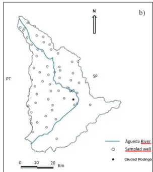
The study area - Águeda watershed - is located in the central west area of the Iberian Peninsula, between Portugal and Spain (Fig. 1a), occupying a total area of 2600 km6. Anthropogenic activities grew exponentially in the last 50
years and the exploitation of natural resources, coupled with changes in consumer habits, induced environmental changes on the local population. Ciudad Rodrigo (Spain) is the main urban and farming region in the Águeda watershed (Fig. 1b).
Fig. 1. (a) Águeda Watershed location; (b) sampling design. SPAIN P ORT UGAL a) b) Ciudad Rodrigo ● ●
In the Águeda transboundary watershed were selected and collected a total of sixty-five groundwater samples, between 1 and 2 m below surface (during May 2012). Selected chemical element contents were analyzed in the Natural Resources and Agro-biology Institute (IRNASA, Salamanca; Spain). Uranium total groundwater content was determined by inductively coupled plasma mass spectrometry.
Sequential Gaussian simulation was used for conditional stochastic simulation of the uranium groundwater concentration distribution. Sequential Gaussian simulation starts by defining the univariate distribution of values, performing a normal score transform of the original values to a standard normal distribution. Simulation of normal scores at grid node locations was done sequentially with simple kriging (SK) using the normal score variogram and a zero mean7,8. Once all normal scores were simulated, they were back-transformed to original grade values. For the computation the Space-Stat software V. 4.0.7 was used9.
3. Results and conclusions
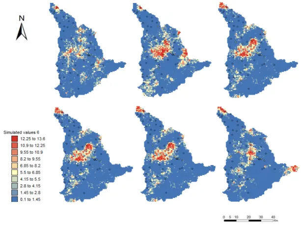
Selected results of multiple uranium simulated realizations are presented in figure 2. The evaluation of the spatial uncertainty allows to conclude that hot spots of U are strongly implanted in the central area of the Águeda watershed (Fig. 2), overlapping the urban area of Ciudad Rodrigo, where is located the principal U abandoned mines. Small variations, in the spatial patterns, can also be observed. Concerning the watershed’s comers, high spatial uncertainty can be observed as the simulated U hot spots shows high variability throughout the simulated realizations (Fig. 2), which could be related to uranium mine exploitations.
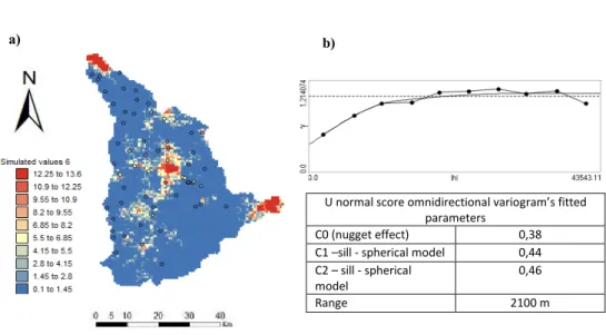
The average simulated map for uranium distribution together with the experimental omnidirectional variogram, and fitted parameters, are shown in figure 3. The average representation stresses the high content of U located in the central part of the Águeda river watershed (Figs. 2 and 3). Local north and east U hot spots can be also identified, with high spatial uncertainty associated though (Fig. 3).
Fig. 3. (a) Average simulated map of uranium content; (b) omnidirectional variogram and fitted parameters.
The obtained results points to the old mining activities as a clear environmental risk factor. These situations should be carefully monitored in future work as they can play an important role as an environmental liability. In addition, the fact that this watershed is shared by two different countries hampers its management and make long-term planning challenging.
Future works spatial uncertainty evaluation allows to define future monitoring and sampling strategies as well as the measurement of remediation possibilities.
Acknowledgements
This research was funded by the POCTEP project “Caracterización ambiental y análisis de riesgos en cuencas transfronterizas: proyecto piloto en el río Agueda” (Ref. CE: 0410_AGUEDA_3_E).
References
1. Zachara JM, Long PE, Bargar J, Davis JA, Fox P, Fredrickson JK, Freshley MD, Konopka AE, Liu C, McKinley JP, Rockhold ML, Williams KH, Yabusaki SB. Persistence of uranium groundwater plumes: Contrasting mechanisms at two DOE sites in the groundwater–river interaction zone. J Cont Hydro 2013; 147: 45-72.
2. Gómez P, Garralón A, Buil B, Turrero MJ, Sánchez L, De la Cruz B. Modeling of geochemical processes related to uranium mobilization in the groundwater of a uranium mine. Sci Total Environ 2006; 366: 295-309.
3. Mkandawire M. Biogeochemical behaviour and bioremediation of uranium in waters of abandoned mines. Environm Sci Pol Resea 2013; 20/11: U normal score omnidirectional variogram’s fitted
parameters
C0 (nugget effect) 0,38
C1 –sill - spherical model 0,44 C2 – sill - spherical
model
0,46
Range 2100 m
7740-7767.
4. Neiva AMR, Carvalho PCS, Antunes IMHR, Silva MMVG, Santos ACT, Cabral Pinto MMS, Cunha PP. Contaminated water, stream sediments and soils close to the abandoned Pinhal do Souto uranium mine, central Portugal. J Geochem Explor 2014; 136: 102-117.
5. Falck WE. The long-term safety of uranium mine and mill tailing legacies in an enlarged EU. European Communities: JCR Scientific and Technical Reports; 2008.
6. Albuquerque MTD, Sanz G, Oliveira SF, Martínez-Alegría R, Antunes IMHR. Spatio-temporal groundwater vulnerability assessment – a coupled remote sensing and GIS approach for historical land cover reconstruction. Water Resour Manage 2013; 27: 4509–4526.
7. Deutsch CV. Geostatistical Reservoir Modeling. New York: Oxford University Press; 2002.
8. Goovaerts P. Geostatistics for natural resources evaluation. New York: Oxford. University Press; 1997. 9. Biomedware. Space-Stat software V. 4.0.7; 2013.