Decision Support System for Surface Irrigation Design
José M. Gonçalves
1and Luis S. Pereira, M.ASCE
2Abstract: The SADREG decision support system was developed to help decision makers in the process of design and selection of farm surface irrigation systems to respond to requirements of modernization of surface irrigation—furrow, basin, and border irrigation. It includes a database, simulation models, user-friendly interfaces, and multicriteria analysis models. SADREG is comprised of two com-ponents: design and selection. The first component applies database information, and through several simulation and computational tools, produces a set of design alternatives in agreement with the user options. These alternatives are characterized by several hydraulic, economic, and environmental indicators that allow appropriate selection and ranking. The selection component bases upon multicriteria analysis using composite programming and ELECTRE II ranking models, which support the decision maker to select the best alternative. The decision maker participates in all decision processes through a user-friendly interface that allows expressing design options and priorities. SADREG was tested with data collected from field experiments. In addition to describing the modeling approach, an application to a sector of the Lower Mondego Irrigation Project, Portugal, is presented.
DOI: 10.1061/共ASCE兲IR.1943-4774.0000004
CE Database subject headings: Irrigation; Economic factors; Environmental issues; Decision support systems; Portugal.
Introduction
Surface irrigation systems have the largest share in irrigated ag-riculture all over the world. The performance of surface irrigation systems highly depends upon the design process, which is related to the appropriateness and precision of land leveling, field shape and dimensions, and inflow discharge. Moreover, the irrigation performance also depends on farmer operative decisions, mainly in relation to land leveling maintenance, timeliness and time du-ration of every irrigation event, and water supply uncertainties 共Pereira 1999; Pereira et al. 2002兲.
The design procedures of farm surface irrigation drastically changed in recent years. The classical ones were based upon em-pirical rules 共Criddle et al. 1956; Wilke and Smerdon 1965兲. A quasi-rational methodology taking into consideration the main de-sign factors was developed by the Soil Conservation Service. It was based upon the continuity equation and was supported by intensive field observations共SCS 1974, 1979兲. This methodology was widely applied and adopted in optimization procedures 共Reddy and Clyma 1981a,b兲. It assumes the soil classification in infiltration family types, related with soil texture, and evaluated from infiltrometer observations 共Hart et al. 1980兲. For furrows design, an empirical advance curve was applied relating inflow discharge, slope, length, and infiltration. Other classical methods refer to the volume-balance models using the continuity equation
and empirical information, but neglecting the dynamic flow equa-tion. Examples are referred by Walker and Skogerboe共1987兲, Yu and Singh 共1989, 1990兲, and Clemmens 共2007兲. These types of models also apply to irrigation management when optimizing the performance from advance data observations共Latimer and Reddel 1990; Mailhol et al. 2005; Camacho et al. 1997兲.
Numerous mathematical computer models for surface irriga-tion simulairriga-tion were developed. They originated a new age on design methods, with increased quality of procedures, because they allow the quantification of the integrated effect of main irri-gation factors共length, discharge, slope, soil roughness, shape, and infiltration兲 on performance, thus, enlarging the solution set with higher precision and effectiveness than the traditionally empirical methods. Strelkoff and Katopodes共1977兲 first presented an appli-cation of zero-inertia modeling for border irrigation. Further de-velopments were described for borders, basins, and furrows 共Fangemeier and Strelkoff 1978; Clemmens 1979; Elliott et al. 1982兲, and were followed by furrow surge flow modeling 共Oweis and Walker 1990兲. The kinematics wave and the hydrodynamics model for furrows were later introduced共Walker and Humpherys 1983; Strelkoff and Souza 1984兲. Computer models for design of basin irrigation include BASCAD 共Boonstra and Jurriens 1978兲 and BASIN 共Clemmens et al. 1993兲, and for border irrigation include the BORDER model共Strelkoff et al. 1996兲. The models SRFR共Strelkoff 1990兲 and SIRMOD 共Walker 1998兲 apply to fur-rows, basin, and border irrigation and adopt various approaches for solving the continuity and momentum equations. Reviews were recently produced by Pereira et al.共2006兲 and Strelkoff and Clemmens共2007兲.
In addition to hydraulics simulation models, surface irrigation design requires the application of other type of models such as for irrigation scheduling, land leveling, distribution systems, and cost and environmental analysis. In practice, it is usually difficult to manage data for an interactive application of these models in design when they are not integrated with a common database. The decision support systems 共DSSs兲 methodology creates the framework to explore the synergy between mathematical simula-tion models, data and user knowledge through its integrasimula-tion 1
Assistant Professor, Agricultural Engineering Research Center, Insti-tute of Agronomy, Technical Univ. of Lisbon, Portugal. E-mail: jmmg@ mail.esac.pt
2
Professor and Head, Agricultural Engineering Research Center, Insti-tute of Agronomy, Technical Univ. of Lisbon, Portugal共corresponding author兲. E-mail: [email protected]
Note. This manuscript was submitted on February 27, 2008; approved on October 1, 2008; published online on January 22, 2009. Discussion period open until November 1, 2009; separate discussions must be sub-mitted for individual papers. This paper is part of the Journal of
Irriga-tion and Drainage Engineering, Vol. 135, No. 3, June 1, 2009. ©ASCE,
aimed to help the decision maker to solve complex problems. The DSS methodology makes handling data of various types easier and effective, and favors the integration of simulation models and their interactive application. It provides for a decision-maker learning process, and through the inclusion of multicriteria analy-sis, it supports a decision process and related choices. DSSs are often applied to irrigation planning and policy analysis共Bazzani 2005; Riesgo and Gómez-Limón 2006兲, as well as to performance assessment and water demand and delivery simulation共Raju and Duckstein 2002; Rao et al. 2004; Oad et al. 2006; Raju et al. 2006; Gonçalves et al. 2007兲. However, few applications are developed for surface irrigation 共Gonçalves and Pereira 1999; McClymont 1999; Hornbuckle et al. 2005兲.
The variety of aspects influencing irrigation performance共Burt et al. 1997; Pereira et al. 2002兲 makes the design process quite complex, and a multicriteria analysis approach is then advanta-geous. Alternative design solutions may be ranked following various objectives and criteria, such as improving the irrigation performance, achieving water saving, attaining high water pro-ductivity, or maximizing farm incomes. Using a DSS and multi-criteria analysis is helpful to produce appropriate comparisons among alternative design solutions and to perform a trade-off analysis共Roy and Bouyssou 1993; Pomerol and Romero 2000兲. In this line, the DSS SADREG for surface irrigation design was developed and tested in a variety of applications. The objective of this paper is to present SADREG and the approaches supporting its development, including results of its application to one irriga-tion sector of the Lower Mondego Irrigairriga-tion Project共Portugal兲.
Architecture of the DSS SADREG
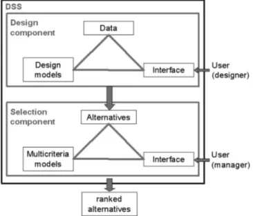
SADREG is a DSS designed to assist designers and managers in the process of design and planning improvements in farm surface irrigation systems—furrow, basin, and border irrigation. It in-cludes a database, simulation models, user-friendly interfaces, and multicriteria analysis models.
SADREG is comprised of two components: design and selec-tion 共Fig. 1兲. The first component applies database information and produces a set of design alternatives in agreement with the
user options. These alternatives are characterized by various hy-draulic, economic, and environmental indicators that allow appro-priate selection and ranking. The selection component is based upon multicriteria analysis for ranking the alternatives, thus, sup-porting the decision maker to select the best design solution. The decision maker participates in all decision processes through in-terface dialogue structures that allow expressing design and man-agement options and priorities.
SADREG is a client-server application whose software fol-lows a high level architecture by layers共Fig. 2兲. The first layer concerns the user interface; the second refers to the application logic, which controls the interactive use of the simulation models when creating the design alternatives. The database constitutes the third layer and is built with Open Data Base Connectivity 共ODBC兲 technology applying Microsoft Access. Microsoft Visual Basic 6 is used to develop the graphical interface and Microsoft Visual C⫹⫹ 6 is used in the computation modules. The dialogue interface structures are user friendly to facilitate the user data input and validation.
The databases refer to data of various natures, some constitut-ing input data required for computations; others are created through successive computations/simulations 共Fig. 3兲. The main components are:
1. General field data, relative to soils and environment 共e.g., soil infiltration, soil water holding capacity, soil salinity, groundwater depth, and climate兲, crops 共planting date, yields, yield function parameters兲, equipment characteristics and costs, operational costs and benefits;
2. Field data characterizing the field under design: length, Fig. 1. Conceptual structure of SADREG
Fig. 2. DSS architecture by layers
Fig. 3. Data base components in relation to respective sources and
width, slopes, surveying data, and characteristics of the re-spective water supply;
3. Data created through simulations performed with the models SIRMOD for surface irrigation simulation共Walker 1998兲 and ISAREG for irrigation scheduling simulation共Pereira et al. 2003兲;
4. Project data, referring to data characterizing the alternatives; and
5. Selection data, referring to the value functions and decision priorities.
SADREG includes various computational models and tools 共Fig. 4兲. The simulation of the surface irrigation systems— furrows, borders, and basins—is performed by the surface irriga-tion simulairriga-tion model SIRMOD 共Walker 1998兲, which is integrated within SADREG. The water balance simulation to de-fine the application depths and timings is performed by the ISAREG model共Pereira et al. 2003兲, which is linked 共loose inte-gration兲 with SADREG and explored interactively. Calculations relative to land leveling and farm water distribution systems are performed through specific built-in tools. These computational tools provide for the characterization of each design alternative, including a complete set of performance indicators. The resulting data are later handled by an impact analysis tool, so creating all data required for multicriteria analysis. The impact analysis tool performs calculations relative to crop yields and related incomes 共benefits兲, costs, and environmental impacts as described later. Ranking and selection of alternatives are performed with compos-ite programming and the ELECTRE II models共Roy and Bouys-sou 1993; Pomerol and Romero 2000兲.
The SADREG applications scope is comprised of共a兲 a single field analysis relative to alternative design options for furrow, basin, or border irrigation, considering several decision variables such as field slopes, farm water distribution systems and runoff reuse; and 共b兲 an irrigation sector analysis, when a spatially dis-tributed database relative to the farm systems is available. In this case, the alternatives are assessed jointly with modernization op-tions relative to the conveyance and distribution network. It ap-plies to farm land parcels or fields, of rectangular shape, with a well known geographical location, supplied by a hydrant, a gate, or other facility at its upstream end. A field is characterized by its length and width, slope and land surface unevenness, soil infiltra-tion and soil water reteninfiltra-tion characteristics, both assumed as spa-tially uniform for design purposes. Large fields may be subdivided into units, which are field fractions supplied by a single outlet, all having the same width, length, and slope. In
addition, subunits may be considered when the water available or management constraints impose that a unit is not fully irrigated simultaneously. In order to design the upstream water distribu-tion, the field characterization requires definition on which direc-tion, OX or OY, the distribution system should be located. Hydrants or farm gates supply the water to the field with known discharge and hydraulic head. In large fields, farm canals or pipes supplied by those hydrants or gates may deliver the water to the upstream distribution system through various outlets, equaling the number of units. In small fields, generally only one unit is con-sidered and the outlet coincides with the hydrant or gate.
A hierarchical approach is used to develop the design alterna-tives共Fig. 5兲. Data referring to field characteristics common to all alternatives are organized in a workspace. Included in the field workspace are the projects whose data structure is aimed at de-veloping a set of design alternatives relative to:
1. The crop type共e.g., cereals versus row crops兲; 2. The irrigation method;
3. The land leveling solution, to be defined in agreement with the irrigation method, field longitudinal and cross-slopes, and the selected upstream distribution side;
4. The water supply conditions that influence, together with the irrigation method, the Options relative to the number and size of units and the outlet’s discharge; and
5. Costs and other financial parameters.
The design alternatives are clustered into groups included in a project and relative to:
1. The upstream distribution system, which depends upon the selected irrigation method and equipment available; and 2. The tail end management system, which also depends upon
the irrigation method and the equipment available.
The alternatives constitute complete design solutions. Within a group, they are differentiated by the operative parameters: the inflow rate per unit width of land being irrigated or per furrow, and the number of subunits.
Irrigation System Design Decision Variables
The surface irrigation methods considered are level basin irriga-tion, with flat or furrowed soil surface, graded basins, borders, and graded furrows 共Table 1兲. Level furrows are treated as fur-rowed level basins. For cereals, furrows of corrugated type may be considered.
The decision variables relative to the irrigation design process are described in Table 2. They depend upon the irrigation method since it influences the field layout and land leveling, the water supply and distribution, the tail water management, and the farm irrigation management.
Land Leveling
When starting a project, the user must select the irrigation method, the upstream distribution side, and carry out a land lev-eling simulation adopting cross and longitudinal field slopes ap-propriate to the considered irrigation method and the actual field slopes. The land leveling simulation tool computes the cut and fill volumes required to change from the actual elevations za共x,y兲
into the target elevations Fig. 4. Model base components
z共x,y兲 = z0+ Sx共x − x0兲 + Sy共y − y0兲 共1兲 where x0, y0, z0= coordinates of the center of gravity of the field 共m兲; and Sxand Sy= longitudinal and cross-slopes共m m−1兲 along
the OX and OY axis, respectively共Dedrick et al. 2007兲. The plan position 共value of z0兲 is iteratively changed until the cut to fill ratio becomes⬎1.0 and ⬍1.2 共Fig. 6兲. Results include the cut and fill depths and volumes, and related costs.
Infiltration and SIRMOD Application
The modified Kostiakov equation is applied in the SIRMOD model共Walker 1998兲 to compute soil infiltration. For continuous flow, it takes the form
Z = K ·a+ f0· 共2兲
where Z = cumulative infiltration 共m3m−1兲; =infiltration time 共min兲; K 共m3m−1min−a兲 and a 共dimensionless兲 are empirically adjusted parameters; and f0= basic infiltration rate 共m3min−1m−1兲. For surge flow, the procedure developed by Walker and Humpherys共1983兲 is adopted:
• For infiltration on dry soil共first wetting兲, Eq. 共2兲 is applied;
• For infiltration on wetted soil 共third and successive wettings兲 the parameters a, K, and f0in Eq.共2兲 are modified into Ks, as,
and f0s, thus, producing the surge infiltration equation; and • For infiltration during the second wetting, a transition curve is
applied.
This transition equation balances the effects represented by the equations for dry and wetted soil共Walker 1998; Horst et al. 2007兲
Z =关K + 共K − Ks兲FP兴关a+共a−as兲FP兴+关f0+共f0− f0s兲FP兴 共3兲 where FP共dimensionless兲=distance-based factor computed from the advance distances xi−2 and xi−1 relative to the surge cycles i − 2 and i − 1.
To characterize each field, SADREG includes a set of infiltra-tion data concerning families of infiltrainfiltra-tion curves for continuous and surge flow, typical of seasonal irrigation events共first, second, and later irrigations兲 under flat soil infiltration conditions. Field observations of infiltration can be added to this set of infiltration curves and be used for the respective design case study. When no field infiltration data are available, the user selects the curves to be used considering the available soil data. To adjust the
param-Table 1. Irrigation Methods
Irrigation method
Soil surface
condition Field slopes Field inflow conditions Tail end conditions Level basin Flat or furrowed Zero in all directions Point inflow at one or various locations,
or to individual furrows
Diked Graded basin
and borders
Flat or furrowed Longitudinal slope⫽0 and cross-slope= 0
Point inflow at one or various locations, or to individual furrows
Diked for basins and open for borders Graded furrows Furrowed Longitudinal
and cross-slope⫽0
Inflow to individual furrows Open or diked
Fig. 5. Scheme of the creation of field design alternatives using a multilevel approach for design and application of multicriteria ranking and
eters for furrow irrigation, the procedure proposed by SCS共1979兲 and Walker共1989兲 is applied. It is based on the average wetted perimeter 共WP兲 共m兲 and the adjusting coefficient 共Cadj兲. WP is given by
WP = 0.265
冉
q · n冑
S0冊
0.425+ 0.227 共4兲
where q = furrow inflow discharge 共l s−1兲; n=Manning’s
rough-ness coefficient 共s m−1/3兲; and So= furrow longitudinal slope
共m m−1兲. The adjusting coefficient C
adjis estimated as Cadj= 0.5, . . . if WP FS ⬍ 0.5 else Cadj= WP FS 共5兲
where FS共m兲=furrow spacing. The parameters K and f0关Eq. 共2兲兴 and the surge-flow infiltration parameters are adjusted as
Kadj= Cadj· K 共6兲
f0adj= Cadj· f0 共7兲
The SIRMOD model is applied for several input conditions that cover all situations relative to the user options to create al-ternatives. The continuous input variables consist of: field length 共FL, m兲, required application depth 共Zreq, mm兲, field longitudinal slope 共So兲, Manning’s hydraulics roughness coefficient 共n兲, fur-row spacing 共FS兲, and inflow rate per unit width or per furrow 共q, l s−1兲. The discrete input variables required are: inflow regime 共continuous or surge flow兲, tail end management 共open, diked, or open with reuse兲, cross-section shape 共flat or various furrow types兲, and parameters of the infiltration equation.
Any run of SIRMOD produces output data including: applica-tion, advance, and recession times; infiltration depths; runoff and percolation volumes; and performance indicators, mainly those defined in Table 3 共Walker and Skogerboe 1987; Pereira and Trout 1999兲.
The SIRMOD model is used iteratively for a given alternative to search the irrigation parameters referred to above that comply with the application of the required irrigation water depth Zreq 共mm兲. This one is computed by running interactively the model ISAREG for the considered crop, soil, and climate. In SIRMOD simulation, an appropriate inflow rate q共qmin⬍q⬍qmax, l s−1m−1兲 is iteratively selected using increments⌬q=0.1 l s−1. However, it may happen that the model does not converge and it becomes
Table 2. Design and Management Decision Variables
Decision variables
Design Field layout and land leveling • Upstream distribution side共OX or OY兲 • Field length共FL兲 and field width 共FW兲 • Cross-slope共SoC兲
• Longitudinal slope共So兲 Water supply conditions • Number of outlets共No兲 • Number of units共Nu兲
• Total field supply discharge共QF兲
• Outlet discharge共Qo兲 and hydraulic head 共Ho兲 • Field delivery time duration共tF兲
Farm distribution system • Continuous and constant inflow rate for basins and borders • Continuous or surge flow with automatic or manual surge valves
for graded furrows
• Lined or unlined canal, or gated pipes, or layflat tubing for all methods
Tailwater management • No tail water runoff for basins and diked furrows • Open without tail water reuse
• Open and reuse by pumping to the upstream end • Open and gravity reuse on other fields
Management Irrigation scheduling • Irrigation timing
• Required application depths • Application time共tap兲
Distribution system operation • Inflow rate per unit width or per furrow共qo兲 • Number of subunits共ns兲
Fig. 6. Flowchart of the application of the land leveling simulation
necessary to have a successful simulation trying different combi-nations of internal simulation parameters 共Walker 1998兲: time step 共1–2.5 min兲, space step 共1–25 m, according to the field length兲, time weight factor 共0.60–0.65兲, space weight factor 共0.50–0.65兲, and type of hydraulics simulation model 共full hydro-dynamic or zero inertia兲. When an inflow rate q is found, a new iteration starts to compute the time tap共min兲 required to apply the water depth Zreq. This is performed by maximizing the water re-quirement efficiency 共Table 3兲, which should become close to 100%. Results are then saved in the database to be further applied to other alternatives. The results for intermediate values for each of the continuous input variables are calculated by interpolation between those stored in the database instead of running the model several times.
Generation of Alternatives
The procedure to build up and characterize design alternatives for a given field is performed through the following sequential steps: 1. Selection of the irrigation method: level basin 共flat or rowed兲, graded basins or border, or graded furrows; for fur-rows, selection includes the cross-section type and the furrow spacing;
2. Definition of the field side, along the axis OX or OY, where the upstream distribution facilities will be located;
3. Land leveling simulation, then choosing the field slopes more appropriate to the irrigation method, and the actual field to-pography;
4. Selection of the inflow regime for graded furrows: continu-ous or surge flow. The surge-flow irrigation management fol-lows the one-fourth length rule for the advance phase, i.e.,
with increased duration of successive cycles; after the ad-vance is completed, a continuous flow with half-inflow rate applied to the full unit is adopted. For basin and borders, only a continuous inflow rate is considered;
5. Definition of the number of outlets and field units;
6. Selection of the water distribution system among gated pipe, lay-flat tubing, earth canal, or lined canal; when the surge-flow option is selected, the respective control system may be either manual or automatically operated;
7. Selection of a tail water management option for borders and furrows: they may be diked, i.e., closed at the tail end, or open. When open, the tail end runoff may be reused by pumping to the upstream end, reused by gravity in down-stream fields, or not reused. Basins are diked; and
8. Estimation of an appropriate crop irrigation scheduling, thus, the required application depths and timings. With this pur-pose, the ISAREG model is used interactively with SIRMOD for searching the application depths appropriate to the irriga-tion method.
Impact Evaluation
The cost analysis considers the investment and the operation and maintenance 共O&M兲 costs 共Mjeld et al. 1990; Solomon et al. 2007兲. The investment cost refers to the farm distribution system equipment and the initial land leveling. The net present value of the investment cost is calculated on a yearly basis using a capital recovery factor that is a function of the annual interest rate and the lifetime of the components 共see the Appendix兲. The annual O&M costs include the land leveling maintenance, the distribu-tion system operadistribu-tion and maintenance, and the reuse pumping costs. The database shall include the duration times relative to all irrigation tasks depending upon the irrigation method and the equipment used 共see the Appendix兲. Both investment and O&M costs vary among the alternatives.
The production costs not referring to irrigation共e.g., fertiliza-tion, cultivafertiliza-tion, and harvesting兲 do not differ among alternatives and do not interfere on ranking and selection of alternatives. Thus, they are not included in the cost analysis.
A water-yield function is used to estimate the crop yield from
Table 3. Performance Indicators共Units in %兲
Indicator Definition Application efficiency Ea=
兵
Zreq D ⫻100 Zlq⬎Zreq Zreq D ⫻100 Zlq⬍Zreq其
Distribution uniformity DU= Zlq Zavg ⫻100 Water requirement efficiencyEr= Zavg共root兲 Zreq ⫻100 Infiltration efficiency IE=Zavg D ⫻100
Tail water runoff ratio
TWR=Zrun
D ⫻100
Deep percolation ratio
DPR=Zdp
D ⫻100
Note: Zreq= the average water depth共mm兲 required to refill the root zone in the lower quarter of the field. D= average water depth applied to the irrigated area共mm兲. Zlq= average depth of water infiltrated in the lower quarter of the field共mm兲. Zavg= average depth of water infiltrated in the whole irrigated area共mm兲. Zavg共root兲= average depth of water infiltrated stored in the root zone共mm兲. Zrun= depth of water that runs off at the tail end of the field共mm兲. Zdp= depth of water that percolates below the root zone共mm兲.
Fig. 7. Irrigation water-yield functions; examples of quadratic
equa-tions with different descending branches for a crop susceptible to excess water in a poorly drained soil共–兲, for a susceptible crop in a drained soil共- - -兲, and for a nonsusceptible crop in a well drained soil共––兲
the computed total water use during the irrigation season. A quadratic function 共Fig. 7兲 is adopted to calculate the relative yield 共Y /Yopt兲 from the relative water application 共W/Wopt兲 共Solomon 1984兲
Y/Yopt= k0+ k1·共W/Wopt兲 + k2·共W/Wopt兲2+ k3·共W/Wopt兲3
+ k4·共W/Wopt兲4 共8兲
where W = actual water available for crop evapotranspiration dur-ing the irrigation season共mm兲; Wopt= seasonal water required for achieving maximum crop yield 共mm兲; Y and Yopt= crop yields 共kg ha−1兲 corresponding to W and W
opt, respectively; and ki 共i
= 1 , . . . , 4兲=empirical coefficients typical for the crop, and envi-ronmental and agronomical conditions under consideration. The decreasing branch of this function is related to soil drainage con-ditions and excess water impacts on yields. To consider these effects, the user should adjust to the local conditions the descend-ing branch of the quadratic function, as indicated in Fig. 8 where three types of descending branches are presented.
The environmental attributes considered for selection of the design alternatives are:
1. The total irrigation water use during the crop season; 2. The nonreused runoff volume, that represents a
noncon-sumed and nonbeneficial fraction of water use and is an in-dicator for potential degradation of surface waters;
3. The deep percolation volume, which represents also a non-consumed and nonbeneficial fraction of water use and is an indicator for potential degradation of ground waters; 4. The potential land leveling impacts on the soil quality; and 5. The potential for soil erosion.
The total water use, runoff, and deep percolation volumes are calculated with SIRMOD for every single event of the irrigation
season. The seasonal values are obtained by summing up these results. The attribute relative to land leveling impacts is expressed by the average cut depth because the smaller are the cut depths, the lower are the impacts on soil quality.
The potential soil erosion attribute is a qualitative index, EI, which takes values 1–9 in an ascending scale of risk of soil ero-sion due to the applied irrigation water. EI is an empirical func-tion of the inflow rate q per unit width or per furrow, the longitudinal slope So, and the soil type considering the empirical concept of maximum nonerosive inflow rate as proposed by Criddle et al. 共1956兲. For furrows in a silt-loam soil, EI values relative to single events are given in Table 4 as a function of the product q So, where q is in l s−1 and So is in percentage. For different soil types, these scale values should change similarly to the maximum nonerosive inflow rate. The seasonal EI is the geo-metric average of the single event values.
Multicriteria Analysis
The selection of the best irrigation design alternative is a multiple objective problem whose rational solution requires multicriteria analysis. This methodology integrates different types of attributes on a trade-off analysis, allowing the comparison between environ-mental and economic criteria共Pomerol and Romero 2000兲. Mul-ticriteria analysis supports a better understanding of the irrigation impacts while enabling us to achieve a satisfactory compromise between adversative decision-maker objectives.
The process starts with the definition of the design objectives and related attributes 共Fig. 8兲. These attributes are then trans-formed into criteria through user-defined value or utility functions 关Eqs. 共9兲 and 共10兲 presented below兴. The alternatives and respec-tive criteria are tabled in a payoff matrix, which synthesizes the more relevant data for the selection analysis. A first screen of the alternatives may be done prior to the application of multicriteria using a dominance and satisfaction preanalysis.
A set of design objectives and correspondent attributes are presented in Table 5. The decision criteria refer to:
1. Economic criteria relative to the yield value, the initial in-vestment cost, and the operation and maintenance costs; and
Table 4. Potential Erosion Index EI for Furrows in a Silt-Loam Soil
q So
l s−1% ⬍0.30 0.3–0.5 0.5–0.62 0.62–0.75 0.75–0.87 0.87–1.0 1.0–1.25 1.25–1.5 ⬎1.5
EI 1 2 3 4 5 6 7 8 9
Table 5. Objectives and Attributes for Design Selection
Objectives Alternative attributes Units Maximizing benefits 1. Yield value €/year Minimizing costs 2. Investment cost €/year 3. Operation and maintenance cost €/year Minimizing water
degradation and the nonbeneficial water use
4. Deep percolation m3/year
5. Runoff m3/year
Maximizing soil conservation
6. Average land leveling cutting depth
cm
7. Erosion index Index
2. Environmental criteria relative to the potential degradation of groundwater and surface waters and the reduction of nonben-eficial water uses relative to tail-end runoff and deep perco-lation, potential erosion due to irrigation water flowing over the soil surface, and soil degradation due to land leveling cuts. Hydraulic criteria are represented in the environmental criteria through controlling runoff and percolation.
The attributes are scaled according to a measure of utility using value or utility functions, which are applied to the environ-mental and economic criteria. This approach enables us to com-pare variables having different units, which is one of the primary benefits of the multicriteria methodology. With this procedure, the utilities Ujfor any criterion j are normalized into the关0–1兴
inter-val 共zero for the more adverse and 1 for the most advantageous result兲.
The following linear utility function is applied for the eco-nomic criteria:
Uj共xj兲 = ␣ · xj+ 共9兲 where xj= attribute;␣=graph slope, negative for costs and
posi-tive for benefits; and parameter=utility value Uj共xj兲 for a null
value of the attribute. A logistic utility function共Fig. 9兲 is adopted for the environmental criteria
Uj共xj兲 = e
Kbj·共xMj−xj兲
eKaj+ eKbj·共xMj−xj兲 共10兲
where Kajand Kbj= function parameters; and xMj= maximum at-tribute value corresponding to a null utility for the j criterion. To adjust this function to user preferences, it is necessary to select the attribute values xaand xbthat correspond to a very low and a very significant impact, e.g., such that U共xa兲=0.95 and U共xb兲
= 0.05, as shown in Fig. 9. Based on these values, and for a specific criterion, the parameters Kaand Kbare then calculated as
follows共Janssen 1992兲: Ka= ln
冋
共1 − U共xa兲兲 . eKb·共␣M−xa兲 U共xa兲册
共11兲 Kb= ln冋
U共xa兲 · 共1 − U共xb兲兲 共1 − U共xa兲兲 · U共xb兲册
xb− xa 共12兲The dominance preanalysis is a procedure to select the non-dominated alternatives. For these alternatives do not exist any other feasible alternative that could improve the performance
relative to any criterion without decreasing the performance of any other criterion. The multicriteria selection applies to those nondominated alternatives. The satisfaction preanalysis screens the alternatives set by selecting the user acceptable ones, i.e., those that for every criterion perform better than a minimum level required by the decision maker.
To apply the multicriteria methods, the user needs to assign priorities by selecting the weights j that represent the relative
importance of each criterion j as viewed by the decision maker. These can be directly defined by the decision maker or calculated by the Analytical hierarchy Process共AHP兲 method 共Saaty 1990兲. Two multicriteria methods may be applied: the composite pro-gramming 共Bogardi and Bardossy 1983兲 and the ELECTRE II 共Roy and Bouyssou 1993; Roy 1996兲. The composite program-ming is an aggregative multicriteria method that leads to a unique global criterion. It is a distance-based technique designed to identify the alternative closest to an ideal solution using a quasi-distance measure. This method allows the analysis of a mul-tidimensional selection problem by a partial representation in a two dimension trade-off surface共e.g., Figs. 12 and 13, which are explained later in more detail兲.
The distance to the ideal point 共Lj= 1 − Uj兲 relative to each
alternative ak, is a performance measure of ak according to the
criterion j. The ideal point represents the point on the trade-off surface where an irrigation design would be placed if the criteria under consideration were at their best possible level. If this dis-tance is short, this performance is near the optimum. The com-posite distance L is computed for each set of N criteria as
L =
冋
兺
j=1 N j· Lj p册
1/p 共13兲 where Lj= distance to the ideal point relative to criterion j; and p = balancing factor between criteria. Each composite distancecorresponds to a distance-based average, arithmetic or geometric, respectively, when p = 1 or p = 2. The balancing factor p indicates the importance of the maximal deviations of the criteria and limits the ability of one criterion to be substituted by another. A high balancing factor gives more importance to large negative impacts 共a larger distance to the ideal point兲 relative to any criterion, rather than allowing these impacts to be obscured by the trade-off process.
The ELECTRE II is an outranking method that aims to rank alternatives. It is based on the dominance relationship for each pair of alternatives, which is calculated from the concordance and discordance indices. The concordance represents the degree to which an alternative k is better than another alternative m. A concordance index is then defined as the sum of weights of the criteria included in the concordance set relative to the criteria for which the alternative k is at least equally attractive as the native m. The discordance reflects the degree to which an alter-native k is worse than alteralter-native m. For each criterion from a discordance set, that includes the criteria for which alternative k is worse than m, the differences between the scores of k and m are calculated. The discordance index, defined as the largest of these differences, reflects the idea that, beyond a certain level, bad per-formances on one criterion cannot be compensated by a good performance relative to another criterion. The decision maker in-dicates the thresholds that are used to establish a weak and a strong outranking relationship between each pair of alternatives.
For every project of a given field共Fig. 5兲, SADREG produces a large set of alternatives as a result of numerous combinations of design and operation variables. As mentioned before, these alter-Fig. 9. Logistic utility function relative to deep percolation where
natives are clustered by groups relative to different water distri-bution equipment and tail end management options. The multicriteria analysis allows the alternative selection for each group and the ranking and comparison of the groups of a given project. This analysis plays an important role on the automatic management of a large amount of data, screening the alternatives, removing those not satisfactory or dominated, and ranking and selecting the most adequate according to the user priorities.
Application
To illustrate the application of multicriteria analysis for surface irrigation design, an application of the DSS SADREG to the sec-tor of Tentúgal of the Lower Mondego Irrigation System, Portu-gal, is presented. This application provided for the evaluation and selection of irrigation methods and water supply systems to be adopted in various farm fields共Gonçalves and Pereira 1999兲. The weights were selected in such a way that priorities assigned to water saving, minimizing costs, and maximizing benefits were balanced.
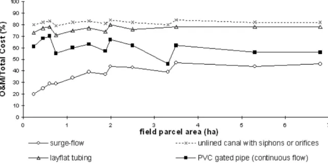
Best Alternatives to Various Parcels and Soil Types The alternative solutions selected after the application of the com-posite programming method are listed in Table 6. Results have shown that the preference for a method is related to the size of the field and to the intake rate of the soil, which is a variable of fundamental importance. However, results were not conclusive concerning the tail end systems. The environmental criteria played an important role in the discrimination among alternatives. This multicriteria approach was applied to a number of fields having different characteristics, mainly concerning the area. Thus, a large amount of data was handled through the DSS, which could provide for more detailed analysis. As an example, an analysis of the economic impacts of various farm water distribution systems in relation to the field area is presented. It refers to the compari-son of total costs of a PVC gated pipe共GP兲 system with other systems—PVC gated pipes with surge-flow valves共GP-SF兲, lay-flat tubing共LF兲, and unlined farm canal with siphons 共CS兲 共Fig. 10兲. The analysis shows that adopting surge flow for small fields
highly increases the costs relative to continuous flow using GP. The difference between GP and GP-SF costs decreases when the field size increases, becoming quite small for areas larger than 2 ha. LF and CS systems are less expensive than GP; differences in costs among all three systems are generally small, mainly up to 2 ha field area.
When the same water distribution systems are compared rela-tive to the share of O&M costs in the total costs, it becomes apparent that surge flow automation 共GP-SF兲 is the one where O&M costs are smaller and CS is the one having larger O&M costs 共Fig. 11兲. The influence of field size is also important. As-signing to O&M costs a weight higher than for investment costs favors adopting systems requiring less labor and more equipment, mainly if equipment is used in other fields, thus, decreasing the respective investment. Contrarily, for small farms, results indicate that adopting water distribution systems requiring less investment and higher labor could be preferable. When ranking alternatives, various factors may be considered to select weights. Giving higher weights to environmental criteria and lower weights to costs may favor the adoption of more expensive water distribution systems.
Selection of the Best Alternative to a Single Field The application example presented herein refers to a field with 200 m length and 100 m width, and a longitudinal slope of 0.10%. Composite programming and the ELECTRE II methods are applied.
Fig. 12 shows the output from the composite programming application to rank the alternatives relative to the economic and environmental criteria. The curves drawn are isodistance lines to the ideal point. Results indicate that the best alternatives are a to
j, which show the same global score. Applying the trade-off
analysis to analyze the impacts in terms of soil conservation and potential for water contamination共Fig. 13兲 allows identifying a,
b, and c as the best alternatives. This partial analysis shown in
Fig. 13 is an advantage of composite programming, because it allows a better evaluation of characteristics that differentiate the alternatives.
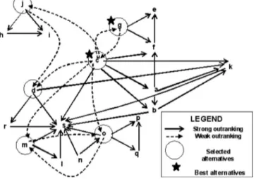
Fig. 14 shows the outranking graph produced through the ap-plication of the ELECTRE II method. The solid line arrows
rep-Table 6. Alternatives Selected Using Composite Programming for Several Land Parcels and Soil Types in Tentúgal Sector
Field sizea
共*兲 Sandy soil Sandy loam soil Loam soil Silty loam soil
100⫻75 -GF, S-GF, Syy= 0.20, diked= 0.20, reuse -GF, Sy= 0.10, diked -GF, Sy= 0.10, diked -GF, Sy= 0.05, diked -LB共furrowed兲 -GF, Sy= 0.05, diked -GB, Sy= 0.05, diked -LB共furrowed兲 -LB共furrowed兲 -GF, Sy= 0.05, diked -GF, Sy= 0.05, reuse 150⫻75 -GF, Sy= 0.20, diked -GF, Sy= 0.20, open -GF, Sy= 0.30, diked -GF, Sy= 0.10, diked -GF, Sy= 0.20, diked -GF, Sy= 0.05, diked -GF, Sy= 0.10, diked -GF, Sy= 0.05, diked -GF, Sy= 0.05, reuse -GF, Sy= 0.05, diked -LB共furrowed兲 -GB, Sy= 0.05, diked 200⫻125 -no acceptable alternatives were made
-GF, Sy= 0.20, diked -GF, Sy= 0.05, diked -GF, Sy= 0.10, diked -GF, Sy= 0.10, diked -GF, Sy= 0.05, diked -GF, Sy= 0.05, reuse -GF, Sy= 0.05, diked -LB共furrowed兲 -GB, Sy= 0.05, diked 265⫻75 -no acceptable alternatives were made
-GF, Sy= 0.10, diked -GF, Sy= 0.05, diked -GF, Sy= 0.05, open -GF, Sy= 0.05, diked -GF, Sy= 0.10, diked -GF, Sy= 0.05, reuse -GF, Sy= 0.05, diked -GF, Sy= 0.05, reuse -GB, Sy= 0.05, reuse 200⫻340 -no acceptable alternatives were made
-GF, Sy= 0.20, reuse -GF, Sy= 0.20, open -GF, Sy= 0.20, diked -GF, Sy= 0.05, diked -GF, Sy= 0.05, open -GF, Sy= 0.05, reuse -GF, Sy= 0.05, diked -LB共furrowed兲 -GB, Sy= 0.05, diked Note: GB= graded border; GF= graded furrows; LB= level basin; Sy= longitudinal slope共%兲.
a
resent the strong outranking between each pair of alternatives. From this outranking共according to the direction of the arrows兲, the alternatives c, d, g, j, m, and o were selected. This set of alternatives is named graph’s kernel. Within the graph’s kernel a weak outranking is established, represented by the dashed arrows. From the respective analysis it could be concluded that the best alternatives are c and g, followed by d, j, m, and o.
It is important to note that by adopting both the ELECTRE II and the composite programming methods, it became easier to select the best alternative c in this application.
Conclusions
Appropriate design of surface irrigation systems requires a complex manipulation of data, models, and decisions. The multi-criteria approach integrated in a DSS enables us to solve that complexity while creating and ranking a large number of de-sign alternatives. The DSS SADREG has shown to be an appro-priate tool for共1兲 generating design alternatives associated with attributes of technical, economic, and environmental nature; 共2兲 handling and evaluating a large number of input and output data; Fig. 10. Differences in costs共EUR/ha/year兲 between a PVC gated pipe system and an unlined field canal, layflat tubing and a gated pipe with an
automatic surge-flow valve as a function of the field area
共3兲 evaluating and ranking design alternatives using multicriteria analysis where criteria are weighted according to the priorities and perception of the designer and users; and 共4兲 providing an appropriate dialogue between the designer and the user.
The application of the DSS to the case study presented herein shows the advantage in adopting two multicriteria analysis mod-els, the composite programming and ELECTRE II, that when used together allow us to find more rationally the best solution. The application also shows that selecting weights for assigning priorities requires appropriate knowledge of factors influencing the ranking, which may imply learning by doing. As for any
simu-lation model, the quality of results not only depends upon the quality of the models but also on the quality of data, particularly field data. Further developments relative to different case studies refer to the GIS linkages for handling data at the sector level, and exploring outputs in the perspectives of enhancing water saving and water productivity.
Acknowledgments
The support granted by the Agricultural Engineering Research Centre, Lisbon, is acknowledged.
Fig. 12. Isodistance lines when ranking alternatives through composite programming and performing a trade-off analysis among economic and
environmental impacts; the best alternatives are a to j
Fig. 13. Isodistance lines when ranking alternatives through composite programming and performing a trade-off analysis relative to impacts on
Appendix. Cost Analysis Equations
Investment costs共IC$兲: Formulas Units
ICva—Present worth cost of one given component
ICva= IC·
共
1 +关
兺j=1 Nsub共
11 + iTA
兲
j·NLT兴兲
€CRF—capital recovery factor
CRF=iTA·共1+iTA兲 NAP
共1+iTA兲NAP− 1
—
AFC—Annual fixed cost AFC= CRF·兺j=1NcompICva
j €/year
ICLL—initial leveling cost ICLL= a0+ a1· tmac €
tmac—time of machine operation required for land leveling
tmac= tuexc· Vexcor tmac= tuarea· A h
ICD—distribution system cost ICD= b0+ b1· FW €
ICR—reuse system cost ICR= r0+ r1· A €
ICT—total investment annual cost ICT= ICLL+ ICD+ ICR €/year
Operation and maintenance costs共OMC$兲:
OMCR—Reuse pumping system cost OMCR= r2· VR €/year
OMCLL—Land leveling maintenance cost OMCLL= a0+ a1· a2· A €/year
OMCD—Distribution system cost OMCD= h⬘0· tMt €/year
tMinst—Man power time to install the distribution system
tMinst= h1· FW h/year
tMrem—Man power time to remove the distribution system
tMrem= h2· FW h/year
tMope—Effective man power time to operate a subunit tMope= h3· SUW h
tMfree—Free man power time in a subunit irrigation tMfree= tap-tMope min
tMopU—Total man power time to operate a unit tMopU= tMopSU· ns, . . . if tMfree⬎tMmin
tMopU= tap· ns, . . . if tMfreeⱕtMmin
h
tMt—Total man power time required by the distribution system
tMt= tMinst+兺j=1 Nirrig共N
u⫻tMopU兲 h/year
OMCT—Total operation and maintenance annual cost OMCT= OMCLL+ OMCD+ OMCR €/year
Fig. 14. Example of an outranking graph relative to the application of the ELECTRE II method to rank the alternatives共the same as in Figs. 12
and 13兲 showing strong and weak outranking among every pair of alternatives according to the arrow directions; the strong outranking allows the identification of the best set of alternatives 共c,d,g, j,m,o兲, and the weak outranking among them permits the final selection of the best alternatives, c and g
Notation
The following symbols are used in this paper: A ⫽ field area 共ha兲;
a0 ⫽ leveling machines fixed cost 共€/operation兲;
a1 ⫽ hourly cost of the land leveling machines 共€/h兲;
a2 ⫽ unitary maintenance leveling machine time 共h/ha兲;
b0 ⫽ distribution system fixed cost 共for example,
valves兲 共€兲;
b1 ⫽ unitary distribution system cost 共€/m兲; FL ⫽ field length 共m兲;
FW ⫽ field width 共m兲;
h0 ⫽ hourly cost of the man power 共€/h兲;
h1 ⫽ unitary man power time to install the distribution system共h/m兲;
h2 ⫽ unitary man power time to remove distribution system共h/m兲;
h3 ⫽ unitary man power time to operate the distribution system共h/m兲;
IC ⫽ investment costs;
iTA ⫽ annual interest rate 共decimal兲;
NAP ⫽ analysis period 共years兲;
Ncomp ⫽ number of equipment components;
Nirrig ⫽ annual number of irrigation events;
NLT ⫽ equipment component life time 共years兲;
Nsub ⫽ number of component replacements during period analysis;
Nu ⫽ number of units per field;
ns ⫽ number of subunits per unit;
r0 ⫽ reuse system fixed cost 共€兲;
r1 ⫽ unitary reuse system cost 共€/ha兲;
r2 ⫽ unitary reuse system variable cost 共€/m3兲;
SUW ⫽ subunit width 共m兲; tap ⫽ application time 共min兲;
tMmin ⫽ additional time required to other tasks relative to irrigation共min兲; it is the minimum time period between subunit operation共closed and open irrigation set兲 that allows irrigation man power to be
allocated to other tasks;
tuarea ⫽ unitary machinery time required to land smoothing 共h/ha兲
tuexc ⫽ unitary machinery for cut volume 共h/m3兲;
Vexc ⫽ land leveling excavation volume 共m3兲; and VR ⫽ pumping reuse volume 共m3/year兲.
References
Bazzani, G. M.共2005兲. “An integrated decision support system for irri-gation and water policy design: DSIRR.” Environ. Modell. Software,
20共2兲, 153–163.
Bogardi, I., and Bardossy, A.共1983兲. “Application of MCDM to geologi-cal exploration.” Essays and surveys on multiple criteria decision
making, P. Hansen, ed., Springer Verlag, New York.
Boonstra, J., and Jurriens, M. 共1978兲. “BASCAD—A mathematical model for level basin irrigation.” ILRI Publication No. 43, Wagenin-gen.
Burt, C. M., et al.共1997兲. “Irrigation performance measures: Efficiency and uniformity.” J. Irrig. Drain. Eng., 123, 423–442.
Camacho, E., Pérez, C., Roldán, J., and Alcalde, M.共1997兲. “IPE: Model for management and control of furrow irrigation in real time.” J. Irrig.
Drain. Eng., 123共4兲, 264–269.
Clemmens, A. J. 共1979兲. “Verification of the zero-inertia model for
border-irrigation advance.” J. Irrig. and Drain. Div., 104共3兲, 339– 341.
Clemmens, A. J.共2007兲. “Simple approach to surface irrigation design: Theory.” e-Journal of Land and Water, 1, 1–19, 具http:// www.sakia.org/ejlw典.
Clemmens, A. J., Dedrick, A. R., and Strand, R.共1993兲. “BASIN 2.0 for the design of level-basin systems.” Management of irrigation and
drainage systems, R. G. Allen, ed., ASCE, New York, 875–882.
Criddle, W. D., Davis, S., Pair, C., and Shockley, D.共1956兲. Methods
for evaluating irrigation systems, USDA SCS Agricultural Handbook
No. 82.
Dedrick, A. R., Gaddis, R. J., Clark, A. W., and Moore, A. W.共2007兲. “Land forming for irrigation.” Design and operation of farm
irriga-tion systems, 2nd Ed., G. J. Hoffman, R. G. Evans, M. E. Jensen, D.
L. Martin, and R. L. Elliot, eds., ASABE, St. Joseph, Mich., 320–346. Elliott, R. L., Walker, W. R., and Skogerboe, G. V.共1982兲. “Zero inertia modeling of furrow irrigation advance.” J. Irrig. and Drain. Div.,
108共3兲, 179–195.
Fangemeier, D. D., and Strelkoff, T.共1978兲. “Mathematical models and border irrigation design.” Trans. ASAE, 22共1兲, 93–99.
Gonçalves, J. M., and Pereira, L. S.共1999兲. “Design of sustainable on-farm surface irrigation systems with a decision support system.”
Emerging technologies for sustainable land use and water manage-ment 共CD-ROM兲, A. Musy, L. S. Pereira, and M. Fritsch, eds.,
Presses Polytechniques et Universitaires Romandes, Lausanne, Switzerland, Paper 8.10.
Gonçalves, J. M., Pereira, L. S., Fang, S. X., and Dong, B.共2007兲. “Mod-elling and multicriteria analysis of water saving scenarios for an irri-gation district in the Upper Yellow River Basin.” Agric. Water
Manage., 94共1–3兲, 93–108.
Hart, W. E., Collins, H. G., Woodward, G., and Humpherys, A. S.共1980兲. “Design and operation of gravity or surface systems.” Design and
operation of farm irrigation systems, M. E. Jensen, ed., ASAE
Mono-graph No. 3, St. Joseph, Mich., 501–580.
Hornbuckle, J. W., Christen, E. W., and Faulkner, R. D.共2005兲. “Use of SIRMOD as a quasi-real time surface irrigation decision support sys-tem.” A. Zerger, and R. M. Argent, eds., Proc., MODSIM 2005 Int.
Congress on Modelling and Simulation, by Modeling and Simulation
Society of Australia and New Zealand, December 2005, 217–223, 具http://www.mssanz.org.au/modsim05/papers/hornbuckle_1.pdf典, Horst, M. G., Shamutalov, S. S., Gonçalves, J. M., and Pereira, L. S.
共2007兲. “Assessing impacts of surge-flow irrigation on water saving and productivity of cotton.” Agric. Water Manage., 87, 115–127. Janssen, R. 共1992兲. Multiobjective decision support for environmental
management, Kluwer, Dordrecht, The Netherlands.
Latimer, E. A., and Reddel, D. L.共1990兲. “A volume balance model for real time automated furrow irrigation system.” Visions of the future—
Technology to enrich our environment, ASAE, St. Joseph, Mich., 13–
20.
Mailhol, J. C., Ruelle, P., and Popova, Z.共2005兲. “Simulation of furrow irrigation practices共SOFIP兲: A field-scale modelling of water manage-ment and crop yield for furrow irrigation.” Interfaces, 24共1兲, 37–48. McClymont, D.共1999兲. “FIDO v2: Furrow irrigation design optimiser.”
Proc., Multiple Objective Decision Support Systems Conf., 具http://
www.ncea.org.au/www/Irrigation/FIDO/Project_FIDO.htm典. Mjeld, J. W., Lacewell, R. D., Talpaz, H., and Taylor, C. R. 共1990兲.
“Economics of irrigation systems.” Management of farm irrigation
systems, G. F. Hoffman, T. A. Howell, and K. H. Solomon, eds.,
ASAE, St. Joseph, Mich., 461–493.
Oad, R., Garcia, L., Kinzli, K. D., and Patterson, D.共2006兲. “Decision support systems for efficient irrigated agriculture.” WIT transactions
on ecology and the environment, Vol. 96, G. Lorenzini, and C. A.
Brebbia, eds., WIT Press, Wessex, U.K., 247–256.
Oweis, T. Y., and Walker, W. R.共1990兲. “Zero-inertia model for surge flow furrow irrigation.” Irrig. Sci., 11共3兲, 131–136.
Pereira, L. S.共1999兲. “Higher performances through combined improve-ments in irrigation methods and scheduling: A discussion.” Agric.
Water Manage., 40共2–3兲, 153–169.
Pereira, L. S., Oweis, T., and Zairi, A.共2002兲. “Irrigation management under water scarcity.” Agric. Water Manage., 57, 175–206. Pereira, L. S., Teodoro, P. R., Rodrigues, P. N., and Teixeira, J. L.共2003兲.
“Irrigation scheduling simulation: The model ISAREG.” Tools for
drought mitigation in mediterranean regions. G. Rossi, A.
Cancel-liere, L. S. Pereira, T. Oweis, M. Shatanawi, and A. Zairi, eds., Klu-wer, Dordrecht, The Netherlands, 161–180.
Pereira, L. S., and Trout, T. J.共1999兲. “Irrigation methods.” CIGR
hand-book of agricultural engineering, land and water engineering, Vol. I.
H. N. van Lier, L. S. Pereira, and F. R. Steiner, eds., ASAE, St. Joseph, Mich., 297–379.
Pereira, L. S., Zairi, A., and Mailhol, J. C.共2006兲. “Irrigation de surface.”
Traité d’irrigation, 2nd Ed., J. R. Tiercelin and A. Vidal, eds.,
Lavoisier, Paris, 513–549.
Pomerol, J. C., and Romero, S. B. 共2000兲. Multicriterion decision in
management: Principles and practice, Kluwer Dordrecht, The
Neth-erlands.
Raju, K. S., and Duckstein, L.共2002兲. “Multicriterion analysis for rank-ing an irrigation system: An Indian case study.” J. Decision Systems,
11, 499–511.
Raju, K. S., Kumar, D. N., and Duckstein, L.共2006兲. “Artificial neural networks and multicriterion analysis for sustainable irrigation plan-ning.” Comput. Oper. Res., 33共4兲, 1138–1153.
Rao, N. H., Brownee, S. M., and Sarma, P. B.共2004兲. “GIS-based deci-sion support system for real time water demand estimation in canal irrigation systems.” Curr. Sci. India, 87, 5–10.
Reddy, J. M., and Clyma, W.共1981a兲. “Optimal design of border irriga-tion system.” J. Irrig. and Drain. Div., 17共3兲, 289–306.
Reddy, J. M., and Clyma, W.共1981b兲. “Optimal design of furrow irriga-tion systems.” Trans. ASAE, 24共3兲, 617–623.
Riesgo, L., and Gómez-Limón, J. A.共2006兲. “Multi-criteria policy sce-nario analysis for public regulation of irrigated agriculture.” Agric.
Systems, 91, 1–28.
Roy, B.共1996兲. Multicriteria methodology for decision aiding, Kluwer, Dordrecht, The Netherlands.
Roy, B., and Bouyssou, D.共1993兲. Aide multicritère: Méthodes et cas, Economica, Paris.
Saaty, T. L.共1990兲. “How to make a decision: the AHP.” Eur. J. Oper.
Res., 48共1兲, 9–26.
Soil Conservation Service共SCS兲. 共1974兲. “Chapt. 4, Border Irrigation.”
Soil conservation service national engineering handbook. Sect. 15, Irrigation, USDA Soil Conservation Service, Washington, D.C.
Soil Conservation Service 共SCS兲. 共1979兲. “Chap.5, Furrow Irrigation.”
Soil conservation service national engineering handbook, Sect. 15, Irrigation, USDA Soil Conservation Service, Washington, D.C.
Solomon, K. H.共1984兲. “Yield related interpretations of irrigation unifor-mity and efficiency measures.” Irrig. Sci., 5共3兲, 161–172.
Solomon, K. H., El-Gindy, A. M., and Ibatullin, S. R.共2007兲. “Planning and system selection.” Design and operation of farm irrigation
sys-tems, 2nd Ed., G. J. Hoffman, R. G. Evans, M. E. Jensen, D. L.
Martin, and R. L. Elliot, eds., ASABE, St. Joseph, Mich., 57–75. Strelkoff, T.共1990兲. “SRFR. A computer program for simulating flow in
surface irrigation furrows-basins-borders.” WC: Rep. 17, U.S. Water Conservation Laboratory, USDA/ARS, Phoenix.
Strelkoff, T., and Clemmens, A. J. 共2007兲. “Hydraulics of surface sys-tems.” Design and operation of farm irrigation systems, 2nd Ed., G. J. Hoffman, R. G. Evans, M. E. Jensen, D. L. Martin, and R. L. Elliot, eds., ASABE, St. Joseph, Mich., 436–498.
Strelkoff, T., Clemmens, A. J., Schmidt, B. V., and Slosky, E. J.共1996兲. “BORDER—A design and management aid for sloping border irriga-tion systems. Version 1.0.” WCL Rep. No. 21. USDA, ARS, USWCL, Phoenix, Ariz.
Strelkoff, T., and Katopodes, N. D.共1977兲. “Border irrigation with zero inertia.” J. Irrig. and Drain. Div., 103共3兲, 325–342.
Strelkoff, T., and Souza, F. 共1984兲. “Modelling the effect of depth on furrow infiltration.” J. Irrig. Drain. Eng., 110共4兲, 375–387. Walker, W. R.共1989兲. “Guidelines for designing and evaluating surface
irrigation systems.” Irrigation and Drainage Paper No. 45, FAO, Rome, Italy.
Walker, W. R.共1998兲. “SIRMOD–Surface irrigation modeling software.” Utah State Univ., Logan, Utah.
Walker, W. R., and Humpherys, A. S.共1983兲. “Kinematic-wave furrow irrigation model.” J. Irrig. Drain. Eng., 109共4兲, 377–392.
Walker, W. R., and Skogerboe, G. V.共1987兲. Surface irrigation: Theory
and practice, Prentice-Hall, Englewood Cliffs, N.J.
Wilke, O., and Smerdon, E. T.共1965兲. “A solution of the irrigation ad-vance problem.” J. Irrig. and Drain. Div., 91共3兲, 23–24.
Yu, F. X., and Singh, V. P.共1989兲. “Analytical model for border irriga-tion.” J. Irrig. Drain. Eng., 115共6兲, 982–999.
Yu, F. X., and Singh, V. P.共1990兲. “Analytical model for furrow irriga-tion.” J. Irrig. Drain. Eng., 116共2兲, 154–171.