Institute of Methodologies for Environmental Analysis, Italian National Council for Research, Tito Scalo (PZ), Italy 2Department Of Sciences, University of Basilicata, Potenza, Italy
aformerly at: Institute of Methodologies for Environmental Analysis, Italian National Council for Research, Tito Scalo (PZ), Italy
†deceased
Correspondence to:E. Gueguen (erwan.gueguen@imaa.cnr.it)
Received: 21 June 2014 – Published in Nat. Hazards Earth Syst. Sci. Discuss.: 24 March 2015 Accepted: 1 November 2015 – Published: 30 November 2015
Abstract. A landslide, to the west of Montemurro (a small village in southern Italy), has recently caused damage to buildings and other infrastructure in an urbanized area; as a result the development of new economic activities has been prohibited. The landslide phenomenon started in the last cen-tury and has been studied since the 1990s using classical geotechnical methods; however the sliding body continues to move. This paper presents the results of a study carried out using field surveys, geognostic investigations and TDR (time domain reflectometry) measurements in order to reconstruct the stratigraphy of the sediments involved and to further un-derstand the geological and geomorphological context of the slope. This study is part of a larger multidisciplinary project, the results of which will also be presented in this paper. The landslide (rotational slide in the upper sector, develop-ing into a translational slide in the lower part) affects Quater-nary continental clastic deposits resting on a bedrock formed by Tertiary siliciclastic sediments of the Gorgoglione Flysch. TDR measurements did not show any significant movement during the period monitored (January 2013–January 2014). Slip zone geometries were hypothesized using inclinometric measurements taken from previous studies, stratigraphic data and geomorphological interpretations of topographic scarps. Feedback from monitoring will confirm this hypothesis.
1 Introduction
Landslides in urbanized environments can cause serious so-cioeconomic damage and loss of human life. As a result, sci-entific interest has increased and has focused on supporting technical studies using integrated methodologies, traditional and innovative techniques, and a scientific approach.
Our attention has been focused on a pilot area in the Agri Valley, Basilicata, southern Italy, on the left orographic side of the Agri River. The studied landslide affects a slope to the west of the town of Montemurro, a semi-urbanized en-vironment where several anthropic buildings have suffered significant structural damage: old farmhouses showing evi-dence of reactivated movement over time; collapsed old dry stone walls; cracked natural spring fountains; and other frac-tured stone or masonry buildings. Roads, retaining walls and a tunnel were also damaged, creating traffic problems and public inconvenience. All of this has resulted in an increased interest in this landslide over the last few years.
2 Methodologies
A detailed geological survey was performed, considering the landslide area and the surrounding slope sectors. Geomor-phological analysis was carried out using field surveys and stereoscopic observations of aerial photographs from the Is-tituto Geografico Militare (IGM). Two series of photographs were used: (1) late summer 1985, 1/31 000 scale, acquisi-tion height of 5330 m; (2) spring 2003, 1/30 000 scale, ac-quisition height of 5000 m.
Two geognostic boreholes (R1, 47.5 m; R2, 40 m) were drilled in order to reconstruct the stratigraphy of the deposits. A pre-existing geognostic borehole (S1), equipped with an inclinometer tube, provided indications of a slip zone, as re-ported by Summa et al. (2015) in this issue. However, the break of the inclinometer tube did not allow for further mon-itoring. As a result, boreholes R1 and R2 were also equipped with TDR (time domain reflectometry) sensors, in order to further evaluate depth and sliding geometry, identify any deeper slip zones and monitor movement.
Groundwater level fluctuations were determined over a hy-drogeological year. Two measurements were taken, Septem-ber 2012 and May 2013, and were considered to be represen-tative of minimum and maximum aquifer recharge, respec-tively. The measurements were performed in boreholes R1 and R2 using piezometers, in other pre-existing geognostic boreholes and in all available water wells, providing the best possible distribution of the measuring points over the study area.
3 Geological setting 3.1 The Agri Valley basin
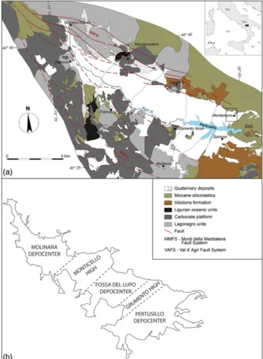
The Agri Valley basin is an inter-mountain basin belonging to the axial sector of the Southern Apennines (Fig.1), an east-verging fold-and-thrust belt developing as an accretionary wedge from late Oligocene to early Pleistocene due to the eastward migration of the Apenninic arc (e.g., Doglioni et al., 1996; Gueguen et al., 1997, 1998; Pescatore et al., 1999; Parotto and Praturlon, 2004; Bucci et al., 2012, 2014).
Lucanian Apennines tectono-stratigraphic units are de-rived from the Afro-Adriatic paleomargin deformation and are tectonically layered as follows: the Liguria-Piedmont Ocean units of the Liguride and Sicilide complex, from Cre-taceous to Oligocene; Apennine Platform carbonate units, from Late Triassic to Tertiary; and the Lagonegro Basin units, from late Paleozoic to Tertiary (e.g., Scandone, 1967; Ogniben, 1969; D’Argenio et al., 1975; Mostardini and Mer-lini, 1986; Carbone et al., 1991; Roure et al., 1991; Monaco et al., 1998; Cello et al., 2000a; Menardi Noguera and Rea, 2000; Lentini et al., 2002; Tavarnelli and Prosser, 2003; Piedilato and Prosser, 2005). Thrust sheet top siliciclastic deposits (e.g., Gorgoglione Flysch) are emplaced by
Ter-tiary upon tectonostratigraphic units indicated above (Car-bone et al., 1991; Butler and Tavarnelli, 2006, and references therein).
The Agri Valley basin (Fig. 2) originates in the lower Pleis-tocene and results from phases of transtension and exten-sion from early Pleistocene to Holocene with two high-angle fault systems, the Val d’Agri fault system described by Cello (2000), Cello et al. (2000a, b, 2003), Bucci et al. (2012, 2014), and references therein, along the NE flank of the basin, and the Monti della Maddalena fault system of Mas-chio et al. (2005), along the southern flank.
The basin is filled by continental clastic Quaternary units which overlay the pre-quaternary bedrock and are repre-sented by coarse-grained slope deposits (Brecce di Galaino and Marsicovetere of Di Niro and Giano, 1995, and Brecce di Serra Mare of Boenzi et al., 2004) and clastic deposits from an alluvial and lacustrine environment (Complesso Val d’Agri of Di Niro et al., 1992, and Giano et al., 2000). The arrangement of these deposits suggests that five generations of slope and alluvial fan systems have developed along the eastern margin of the valley from Pleistocene to Holocene (Giano, 2011).
The interpretation of seismic surveys and electrical resis-tivity tomography (ERT) profiles in the Agri Valley basin al-lowed for the identification of the three fault-bounded de-pocenters: Molinara, Fossa del Lupo and Pertusillo (Fig. 2b), separated by the transversal intrabasinal highs of Monticello and Grumento (Morandi and Ceragioli, 2002; Lapenna and Rizzo, 2003; Colella et al., 2004; Rizzo et al., 2004).
3.2 Geological background from previous studies The area surrounding the village of Montemurro is located near the Agri Valley Pertusillo depocenter, where the sedi-ments of the “Agri Valley allogroup” crop out, as described by Zembo (2010), who proposed a new allostratigraphic model for the basin’s deposits. The Agri Valley allogroup, up to 100 m thick, consists of four unconformity-bounded units, representing distinct depositional intervals related to regional tectonic and environmental changes, overlaying the lower Pleistocene deposits of the Spinoso conglomerate for-mation (Zembo et al., 2009; Zembo, 2010). From bottom to top, the Agri Valley allogroup is composed of Pietra del Per-tusillo alloformation, Valle del Nasillo alloformation, Val-lone dell’Aspro alloformation and Torrente Casale allofor-mation. This sequence reflects a progradation of fan systems in a lacustrine-palustrine setting, followed by expansion of a new alluvial-fluvial system (Zembo, 2010).
Figure 1.Geological sketch map of the Lucanian Apennines with the site of the study area (modified from Patacca and Scandone, 2007).
bottom to top, representative of coeval fluvial plain, alluvial fan and lacustrine deposits, respectively – and matches the Agri Valley allogroup of Zembo (2010) and the Complesso Val d’Agri of Di Niro et al. (1992), Di Niro and Giano (1995) and Boenzi et al. (2004).
In the Agri Valley basin, from Pleistocene to Holocene, Giano (2011) recognized five generations of slope and al-luvial fan systems, consisting of coarse-grained slope and alluvial deposits with reddish paleosols interbedded with, or on top of, the sedimentary fans. The oldest fan sys-tem corresponds to the Spinoso conglomerate formation of Zembo (2010) and to the unconformity-bounded strati-graphic unit in which Carbone et al. (2010) included the Brecce di Galaino and the Conglomerati di La Serra, while the subsequent fan systems can be related to the Agri Val-ley allogroup deposits of Zembo (2010) and the Pietra del Pertusillo supersynthem of Carbone et al. (2010).
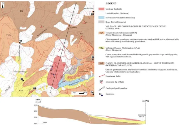
Figure 2.Geological sketch map of the Val d’Agri Basin (modified from Giocoli et al., 2015). Dashed black lines indicate the limits between highs and depocenters.
4 New geological frameworkfrom field surveys
The field surveys carried out during this work define a de-tailed geological setting of the area and recognize the re-ciprocal stratigraphic or tectonic contacts between the dif-ferent outcropping formations, as shown in the sketch map and sketch section in Fig. 3.
In the studied area, mainly continental clastic Quaternary deposits of slope, alluvial and lacustrine environments out-crop. These deposits rest on a bedrock formed by the Tertiary siliciclastic sediments of the Gorgoglione Flysch, observed in several outcrops distributed mainly upstream from the vil-lage of Montemurro, and in the more engraved ditches.
Figure 3.Geological sketch map and geological section (A–A′
) of the study area. Letters O1 to O6 indicate outcrops locations cited in the text, and boreholes are indicated as S1, R1 and R2.
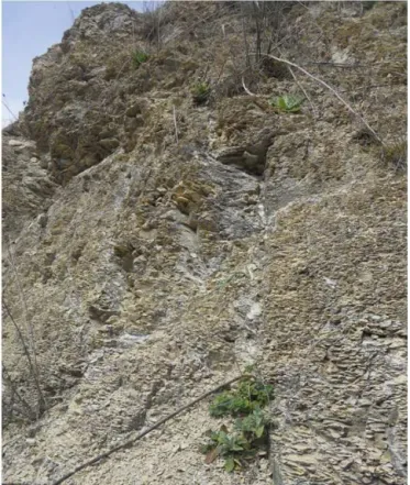
Figure 4.Outcrops of the Gorgoglione Flysch pelitic-arenaceous sequence at the confluence between Scannamogliera and Notar-mario streams(a)and in the village of Montemurro(b), where sev-eral buildings rest upon massive sandstones.
silty-arenaceous-marly), interbedded and repeated several times at different stratigraphic heights, marking several pul-sating turbiditic events (Boenzi et al., 1968; Boenzi and Cia-ranfi, 1970; Critelli and Loiacono, 1988; Mutti and Nor-mark, 1987). In the studied area the pelitic-arenaceous se-quence prevails. The main outcrops are upstream from the village of Montemurro, close to the San Vito Pass, and along a large section extending from the village’s cemetery to the Scannamogliera stream. Other outcrops affect all the inci-sions of this stream, up to the confluence of the Notar-mario ditch, where one of the best exposures can be seen (outcrop O1, Fig. 4a). The northern part of the village is
Figure 5.Outcrop of the Gorgoglione Flysch pelitic-arenaceous se-quence at the San Vito Pass. Grey or yellowish sandstones and grey or brown silty marls and silty clays are interbedded. In the zoom box(a)the very sharp contact between sandstones and the underly-ing pelitic level is shown
Figure 6. Exposure of the Gorgoglione Flysch arenaceous-marly sequence. Grey and whitish marls, silty marls and marly clays, strongly fragmented in slivers and scraps.
and interbedded silty clays. The decimetric to metric sand-stone banks often show yellow ochre surfaces altered with whitish veins, carbonatic-cement-filled, and a graded verti-cal bedding characterized by breccias with millimeter- and centimeter-diameter pebbles at the base. These basal breccias rest on the underlying pelitic level with a very sharp contact, while the transition upward to the finer upper level is more gradual (outcrop O3, Fig. 5).
An isolated outcrop representative of the arenaceous-marly sequence is located on the right orographic side of the Scazzera ditch, SW of the village of Montemurro. It is characterized by grey and whitish marls, silty marls and marly clays, strongly interbedded and fragmented in slivers and scraps, due to intense tectonic deformation (outcrop O4, Fig. 6).
In the study area the continental clastic Quaternary se-quence rests on an angular unconformity truncating the Miocene bedrock, as shown in the geological sketch section in Fig. 3. It is represented by alluvial fan, alluvial plain and lacustrine deposits, corresponding to the middle and upper intervals of the Complesso Val d’Agri of Di Niro et al. (1992) and to the Vallone dell’Aspro and Torrente Casale alloforma-tions of Zembo (2010).
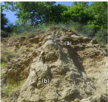
Figure 7.Artificial scarp along the SP11 road, with a representative exposure of the Vallone dell’Aspro deposits. Below a 1 m thick soil (a)there are pebbly sands(b)and grey clayey silts(c). A very dark 40 cm thick, organic-matter-rich peaty level can be observed near the base of the outcrop(d).
Most of the Pleistocene deposits affecting the study area can be attributed to the Vallone dell’Aspro alloformation, characterized by coarse to fine sands and stratigraphically lower greenish to grey silty clay and clayey silts, interbedded with organic-rich peaty levels. Both upward and downward, along the stratigraphic sequence, clast-supported coarse con-glomerates and sandy gravels can be observed. The upper conglomerates show imbricated pebbles of different com-position, mainly arenaceous and subordinately siliceous and igneous, while the composition of the lower gravels, often characterized by a reddish sandy matrix, is mainly dolomitic, calcitic, siliceous and arenaceous, with rarer clasts of varicol-ored argillites and metamorphic rocks (Zembo, 2010). This alloformation corresponds to an axial braided alluvial sys-tem where the water and sediment supply was from both the mainstream and transverse alluvial fans. This environment was also characterized by fossil-refilled channels, pools and ponds; temporary lacustrine-palustrine settings associated with flood events; interfluves areas, as shown by the accu-mulations of mollusk assemblages typical of open vegetated zones; organic layers representative of a standing swamp area; and flash-flood-laminated structures (Beraldi-Campesi et al., 2006; Pisegna Cerone, 2008; Zembo, 2010).
Figure 8.Representative outcrop of the Torrente Casale alloforma-tion. Clast-supported massive conglomerates(a)upon sandy gravels and gravelly sands(b).
reddish ferruginous concretions and more calcareous whitish levels and vegetal fragments. The grain-size finer facies of the Vallone dell’Aspro alloformation is represented in this outcrop by grey clayey silts with a progressive downward darkening due to the increase of the organic matter content, with a 40 cm thick peaty level. It contains vegetal fragments and plant frustules, and it shows, on the fresh exposure, a very dark coloring due to its very high organic matter con-tent. This coloring decreased over the months, due to oxida-tive processes involving organic matter.
The Vallone dell’Aspro alloformation’s coarser conglom-eratic and gravelly component outcrops along the Scan-namogliera stream, mainly on its right orographic side. The best outcrop can be observed upstream from the Dell’Avena Bridge, at 570 m a.s.l., and is characterized by clast-supported conglomerates, with a reddish matrix and millimeter- to centimeter-thick polygenic clasts, interbedded with thin silty and arenaceous beds. Exposures of sands and gravels also outcrop on the vertical or sub-vertical walls de-limiting the topographic highs where the village of Monte-murro and some of its rural settlements are located. These walls expose yellow ochre laminated or massive sandy silts and silty sands interbedded with centimeter- to decimeter-thick sandy matrix gravelly levels containing polygenic and polymictic clastic components.
The Torrente Casale alloformation crops out only in the topographically higher areas, with several outcrops observed, mainly on the left orographic side of the Notarmario ditch, in the I Piani area, and along the Santovecchio stream.
The most representative outcrop of these deposits is in the I Piani area, at 671 m a.s.l., where a sequence of about 12 m can be observed (outcrop O6, Fig. 8). This outcrop shows, below a metric soil coverage, clast-supported massive con-glomerates, with a yellowish sandy matrix and a heteromet-ric cobble- to boulder-sized clastic component, represented mainly by the sandstones of the Gorgoglione Flysch and the Albidona Formation cherts, and igneous and metamor-phic clasts. The sandy component increases downward and appears as matrix-supported sandy gravels with polygenic millimeter- to centimeter-thick clasts, and as yellow ochre sands. The same characters can be recognized in other out-crops in the study area.
The contact between the Torrente Casale and Vallone dell’Aspro alloformation deposits is a composite surface, erosional in the north and depositional towards the basin, based upon a weathering profile composed of a fersial-litic/brunified pedocomplex with two paleosols correspond-ing with two erosion episodes (Zembo, 2010). In the study area, this surface can be observed, though it is laterally dis-continuous, at about 650 m a.s.l., at the top of the vertical walls on the left orographic side of the Scazzera stream, and it shows a moderate rubification due to iron and manganese oxides and hydroxides.
The Quaternary continental deposits, which stratigraphi-cally overlay the Miocene bedrock in an onlap relationship, are plan-parallel, arranged in subhorizontal to gently south-dipping strata towards the basin depocenter.
5 Geomorphological setting
Results of the geomorphological analysis carried out in the area studied are reported in the geomorphological sketch map shown in Fig. 9.
The western side of the village of Montemurro is charac-terized by an obvious slope change controlled by the differ-ent strength of the outcropping lithologies. The presence of alternating turbidite sandstones, siltstones and silty clays in the northern sector produces steeper slopes than the southern sector, where Quaternary deposits consisting of conglomer-ates, sands and clays occur. The area is characterized by a wide geomorphological instability involving the entire slope from the Scazzera stream, 810 to 590 m above sea level and 1500 m in length.
Landslides affect mainly Quaternary continental deposits of the Val d’Agri Basin and also, in the topmost slope sec-tor, the Gorgoglione Flysch sandstones. In some cases, it is possible to recognize landslide main scarps, minor scarps, terrace-like features and counter-slopes, which are particu-larly pronounced along the southern sector of the slope. Ge-omorphological trenches in the foothills of fault scarps and landslide niches have also been observed.
Figure 9.Geomorphological sketch map. The geomorphological profile outline along the A–A′
trace is illustrated in Fig. 13.
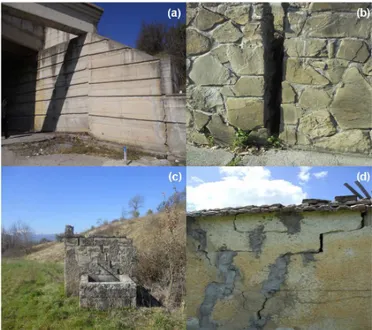
Figure 10.Evidence of deformation and warping on the road tunnel (a), retaining walls(b), and old building(c–d).
cemetery to the north, by the Montemurro high to the east, by the conoid southwestward of the cemetery to the west and by the Scazzera ditch to the south. The damaged area is about 40 ha, and subsoil geological structures have been completely reworked and altered. The entire area is still ac-tive and has been affected by many smaller landslide events.
Now, the main landslide activity affects the slope in the Verdesca area, where significant evidence of ongoing activ-ity has been observed; this consists of structural damage to infrastructure and anthropic buildings (e.g., dislocation of SP11 road tunnel box; warping of retaining walls; and de-formation of road embankments, road surfaces and old man-made structures; Fig. 10; Bentivenga et al., 2012).
The area is affected by a complex landslide, about 700 m long and 325 m wide, developed between 675 and 590 m a.s.l., with a maximum elevation difference of about 85 m between the upper and the lower portions of the land-slide body. The size of the damaged area is about 20 ha. The steepness of the landslide body in the accumulation area is about 14◦
, while it is about 12◦
in the source area.
In the upper sector this landslide is a rotational slide, evolving, in the lower part, into a translational slide (Varnes, 1978; Cruden and Varnes, 1996). The landslide foot has been affected by further superficial movements, due to the contin-uous erosion of the Scazzera stream, whose course is diverted in relation to the zone accumulation. Two piezometric surfac-ing sprsurfac-ings were identified inside the landslide, in relation to minor scarps.
6 Stratigraphies and geognostic investigations
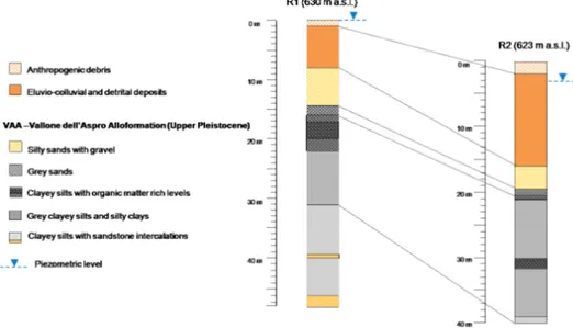
Figure 11. Main stratigraphic features of the logs reconstructed along the R1 and R2 boreholes, showing a sequence of sandy and silty sediments resting on clayey silts with blackish peaty levels.
Figure 12.Isopiezometric maps. Groundwater is consistently close to ground level, and little fluctuations were identifed between the periods of maximum and minimum acquifer recharge.
The first sediments found were attributed to eluvio-colluvial and detritic deposits, with thickness increasing downstream up to a maximum of 14 m in borehole R2. Below these deposits, sandy-silty sediments were observed, with a clayey component strongly varying with depth. The predom-inant yellow ochre coloring is due to the high weathering rate, favored by the significant deconstruction of the sedi-ments and the groundwater circulation. In the borehole, the coarser silty-sandy sediments switch to clayey silts, with sev-eral interbedded blackish peaty levels, at sevsev-eral stratigraphic depths. This transition shows a deepening downstream, drop-ping from 16 to 20.5 m below ground level. Silty levels af-fected by dark nodules and blackish saline concretions can also be observed, respectively due to oxidation phenomena and solution–precipitation processes favored by groundwater circulation. These stratigraphic logs are consistent with that of the S1 borehole, described by Summa et al. (2015). The
clastic component increases with depth, anticipating the ap-pearance of sandstone strata at about 40 m depth in borehole R1.
From a hydrogeological point of view, groundwater is con-sistently close to ground level, and fluctuations of a few cen-timeters were identified between the periods of maximum and minimum aquifer recharge. The anomalously higher val-ues of the groundwater level in the central sector of the area studied are probably linked to engineering draining ac-tions carried out in the past along the provincial road. The isopiezometric maps are shown in Fig. 12.
TDR measurements were carried out every 2 months from January 2013 until January 2014, using a Megger 2000 in-strument and a RG-58 rigid coaxial cable for deformation measurements with a tinned copper inner conductor (50 ohm) and PVC jacket installed in both R1 and R2 boreholes. In-strumental accuracy was 0.1 % of range. However no signif-icant movement was detected.
7 Discussion and conclusions
Field surveys and stratigraphic interpretations of geognostic boreholes enabled us to define a detailed geological, geomor-phological and hydrogeological framework of the study area; to understand some important features of the landslide; and to reconstruct the trend of the slip zone.
silty sediments resting on clayey silts, with a blackish peaty level. The investigated sequence is consistent with that re-constructed along boreholes R1 and R2: from this analogy, it is possible to ascribe the sediments affected by the landslide studied, in total or partly, to the finer facies of the Vallone dell’Aspro alloformation. These sediments can be considered saturated during the entire hydrogeological year, principally in relation to the areas showing more significant evidence of instability, such as that of the road tunnel (Verdesca area).
The Verdesca landslide is complex, being characterized by a rotational slip evolving downstream into a translational slip. Recent movements involving a road tunnel, retaining walls and other manmade structures cracked an inclinome-ter tube in a pre-existing borehole at 14.3 m depth located near the road tunnel, allowing for the identification of a slip zone at that depth (Summa et al., 2015).
We reported in the geomorphological profile A–A′
(Fig. 13) the trend of the hypothesized slip zones, consider-ing both lithological transition (also easily identified in bore-holes R1 and R2 at a depth ranging between 16 and 20.5 m below ground level) and the geomorphological interpretation of topographic scarps.
Only further TDR measurements will make it possible for us to confirm or modify the hypothesized slip zone geome-tries, as no significant movements were detected in the mon-itored period (January 2013–January 2014). In this phase, pending direct feedback from TDR monitoring, geomorpho-logical reconstruction of the slip zones and stratigraphic in-terpretations of geognostic holes have been valuable support tools for defining the slip of the landslide studied and for planning technical interventions aimed at mitigating risk and preserving existing manmade structures.
Acknowledgements. We thank E. Norelli for his positive and constructive discussions. We dedicate this paper to Ivana Adurno; with her strength, her joy and will for life she has been a model for all of us.
Edited by: V. Lapenna
Bentivenga, M., Palladino, G., and Caputi, A.: Development of the Pietra Maura landslide and interactions with the Marsico Nuovo dam (Basilicata – Italy), Geogr. Fis. Din. Quat., 35, 13– 22, doi:10.4461/GFDQ.2012.35.2, 2012.
Beraldi-Campesi, H. B., Cevallos-Ferriz, S. R. S., Centeno-Garcia, E., Arenas-Abad, C., and Fernandez, L. P.: Sedimentology and paleoecology of an Eocene-Oligocene alluvial-lacustrine arid system, Southern Mexico, Sediment. Geol., 191, 227–254, 2006. Boenzi, F., Capolongo, D., Cecaro, G., D’Andrea, E., Giano, S. I., Lazzari, M., and Schiattarella, M.: Evoluzione geomorfolog-ica polifasgeomorfolog-ica e tassi di sollevamento del bordo sud-occidentale dell’alta Val d’Agri (Appennino Meridionale), Boll. Soc. Geol. Ital., 123, 357–372, 2004.
Boenzi, F. and Ciaranfi, N.: Stratigrafia di dettaglio del “Flysch di Gorgoglione” (Lucania), Memorie della Società Geologica Ital-iana, 9, 65–79, 1970.
Boenzi, F., Ciaranfi, N., and Pieri, P.: Osservazioni geologiche nei dintorni di Accettura e di Oliveto Lucano, Memorie della Società Geologica Italiana, 7, 379–392, 1968.
Boiano, U.: Anatomy of a siliciclastic turbidite basin: the Gor-goglione Flysch, Upper Miocene, southern Italy: physical stratig-raphy, sedimentology and sequence stratigraphy framework, Sed. Geol., 107, 231–262, 1997.
Bucci, F., Novellino, R., Guglielmi, P., Prosser, G., and Tavarnelli, E.: Geological map of the northeastern sector of the high Agri Valley, Southern Apennines (Basilicata, Italy), J. Maps, 8, 282– 292, 2012.
Bucci, F., Novellino, R., Tavarnelli, E., Prosser, G., Guzzetti, F., Cardinali, M., Gueguen, E., Guglielmi, P., and Adurno, I.: Frontal collapse during thrust propagation in mountain belts: a case study in the Lucania Apennines, Southern Italy, J. Geol. Soc., London, doi:10.1144/jgs2013-103, in press, 2014. Butler, R. W. H. and Tavarnelli, E.: The structure and Kinematics of
substrate entrainment into high-concentration sandy turbidites: a field example from Gorgoglione “flysch” of southern Italy, Sedi-mentology, 53, 655–670, 2006.
Carbone, S., Catalano, S., Lentini, F., and Monaco, C.: Le unità stratigrafico-strutturali dell’Alta Val d’Agri (Appennino Lucano) nel quadro della evoluzione del sistema catena–avanfossa, Mem-orie della Società Geologica Italiana, 41, 331–341, 1988. Carbone, S., Catalano, S., Lazzari, S., Lentini, F., and Monaco, C.:
Carbone, S., Giano, S. I., Lentini, F., and Tescione, M.: Expanatory notes of the Italian Geological Map to 1:50000 map scale. Sheet 505 Moliterno, ISPRA, Dipartimento Difesa Del Suolo, Servizio Cartografico, Relazioni e Documentazioni di Base, Roma, Italy, 1–107, 2010.
Cello, G.: A quantitative structural approach to the study of active fault zone in the Apennines (Peninsular Italy), J. Geodyn., 29, 265–292, 2000.
Cello, G., Gambini, R., Mattioni, L., Mazzoli, S., Read, A., Tondi, E., and Zucconi V.: Geological analysis of the High Agri Val-ley (Lucanian Apennines, Southern Italy), Memorie della Società Geologica Italiana, 55, 149–155, 2000a.
Cello, G., Gambini, R., Mazzoli, S., Read, A., Tondi, E., and Zuc-coni, V.: Fault zone characteristics and scaling properties of the Val d’Agri Fault System (Southern Apennines, Italy), J. Geodyn., 29, 293–307, 2000b.
Cello, G., Tondi, E., Micarelli, L., and Mattioni, L.: Active tectonics and earthquake sources in the epicentral area of the 1857 Basili-cata earthquake (southern Italy), J. Geodyn., 36, 37–50, 2003. Ciaranfi, N.: Il Flysch di Gorgoglione, Boll. Serv. Geol. It., 92, 101–
114, 1972.
Colella, A.: Medium-scale tractive bedforms and structures in Gor-goglione Flysch (lower Miocene; Southern Apennines, Italy), Boll. Soc. Geol. Ital., 98, 483–494, 1979.
Colella, A., Lapenna, V., and Rizzo, E.: High-resolution imaging of the High Agri Valley basin (southern Italy) with electrical resis-tivity tomography, Tectonophysics, 386, 29–40, 2004.
Critelli, S. and Loiacono, F.: Provenienza e dispersione dei sedi-menti nel Flysch di Gorgoglione (Langhiano-Tortoniano, Appen-nino Lucano); implicazioni sull’evoluzione delle mode detritiche arenacee nell’orogene sudappenninico, Memorie della Società Geologica Italiana, 41, 809–826, 1988.
Cruden, D. M. and Varnes D. J.: Landslide types and processes, in: Landslides: Investigation and Mitigation, Transportation Re-search Board Special Report, 247, edited by: Turner A. K. and Schuster R. L., National Accademy Press, Washington D.C., 36– 75, 1996.
D’Argenio, B., Pescatore, T., and Scandone, P.: Structural pattern of the Campania–Lucania Apennines, Quaderni di Ricerca Sci-entifica, 90, 313–327, 1975.
Di Niro, A. and Giano, S. I.: Evoluzione geomorfologica del bordo orientale dell’Alta Val d’Agri (Basilicata), Studi Geologici Camerti, Special Issue 1995/2, 207–218, 1995.
Di Niro, A., Giano, S. I., and Santangelo, N.: Primi dati sull’evoluzione geomorfologica e sedimentaria del bacino dell’alta Val d’Agri (Basilicata), Studi Geologici Camerti, Spe-cial Issue 1992/1, 257–263, 1992.
Doglioni, C., Harabaglia, P., Martinelli, G., Mongelli, F., and Zito, G.: A geodynamic model of the Southern Apennines accre-tionary prisms, Terra Nova, 8, 540–547, 1996.
Giano, S. I.: Quaternary alluvial fan systems of the Agri intermon-tane basin (southern Italy): tectonic and climatic control, Geol. Carpath., 62, 65–76, 2011.
Giano, S. I., Maschio, L., Alessio, M., Ferranti, L., Improta, S., and Schiattarella, M.: Radiocarbon dating of active faulting in the Agri high valley, southern Italy, J. Geodyn., 29, 371–386, doi:10.1016/S0264-3707(99)00058-7, 2000.
Giocoli, A., Stabile, T. A., Adurno, I., Perrone, A., Gallipoli, M. R., Gueguen, E., Norelli, E., and Piscitelli, S.: Geological and
geo-physical characterization of the southeastern side of the High Agri Valley (southern Apennines, Italy), Nat. Hazards Earth Syst. Sci., 15, 315–323, doi:10.5194/nhess-15-315-2015, 2015. Gueguen, E., Doglioni, C. and Fernandez, M.: Lithospheric
boudi-nage in the Western Mediterranean back-arc basins, Terra Nova, 9, 184–187, 1997.
Gueguen, E., Doglioni, C., and Fernandez, M: On the post-25 Ma geodynamic evolution of the Western, Tectonophysics, 298, 259– 269, 1998.
Lapenna, V. and Rizzo, E.: Tomografie geoelettriche dipolari del bacino dell’Alta Val d’Agri, in: Le Risorse Idriche Sotterra-nee dell’Alta Val d’Agri, Autorità Interregionale di Bacino della Basilicata, Potenza, Italy, 87–111, 2003.
Lentini, F., Carbone, S., Catalano, S., and Monaco, C.: Confronti sedimentologici-petrografici e posizione strutturale dei Flysch di Albidona e di Gorgoglione nella media Val d’Agri (Appennino lucano), Memorie della Società Geologica Italiana, 38, 259–273, 1987.
Lentini, F., Carbone, S., Di Stefano, A., and Guarnieri, P.: Strati-graphical and structural constraints in the Lucanian Apennines (Southern Italy): tools for reconstructing the geological evolu-tion, J. Geodyn., 34, 141–158, 2002.
Loiacono, F.: Geometrie e caratteri deposizionali dei corpi are-nacei nella successione stratigrafica del Flysch di Gorgoglione (Miocene superiore, Appennino meridionale), Boll. Soc. Geol. Ital., 112, 909–922, 1993.
Maschio, L., Ferranti, L., and Burrato, P.: Active extensional in Val d’Agri area, Southern Apennines, Italy: implications for the ge-ometry of the seismogenic belt, Geophys. J. Int., 162, 591–609, 2005.
Menardi Noguera, A. and Rea, G.: Deep structure of the Campanian-Lucanian Arc (Southern Apennine, Italy), Tectono-physics, 324, 239–265, 2000.
Monaco, C., Tortorici, L., and Paltrinieri, W.: Structural evolution of the Lucanian Apennines, Southern Italy, J. Struct. Geol., 20, 617–638, 1998.
Morandi, S. and Ceragioli, E.: Integrated interpretation of seismic and resistivity images across the “Val d’Agri” graben (Italy), Ann. Geophys., 45, 259–271, 2002,
http://www.ann-geophys.net/45/259/2002/.
Mostardini, F. and Merlini, S.: Appennino centro meridionale. Sezioni geologiche e proposta di modello strutturale, Memorie della Società Geologica Italiana, 35, 177–202, 1986.
Mutti, E. and Normark, W. R.: Comparing examples of modern and ancient turbidite systems: problems and concepts, in: Ma-rine clastic sedimentology, edited by: Leggett, J. K. and Zuffa, G. G., Graham and Trotman, London, 1–38, 1987.
Ogniben, L.: Schema introduttivo alla geologia del confine calabro-lucano. Memorie della Società Geologica Italiana, 8, 453–763, 1969.
Parotto, M. and Praturlon, A.: The Southern Apennines arc, in: Ge-ology of Italy, Special Volume of the Italian Geological Society for the IGC 32 Florence-2004, edited by: Crescenti, V., D’Offizi, S., Merlino, S., and Sacchi, L., 33–58, 2004.
formation in the Southern Appennines accretionary wedge, Earth Planet. Sci. Lett., 102, 395–412, 1991.
Salvador, A.: Unconformity-bounded stratigraphic units, Geol. Soc. Am. Bull., 98, 232–237, 1987.
Scandone, P.: Studi sulla geologia lucana: la serie calcareo-silico-marnosa e i suoi rapporti con l’Appennino Calcareo, Bollettino della Società dei Naturalisti in Napoli, 76, 1–175, 1967.