São Paulo: Urban
segregation and inequality
F
lávio
v
illaça
Introduction
P
erhaPS the biggest advance ever in geography has been recent awareness and dissemination of the idea (Lefèbvre, harvey, Gottdiener and others) that social space - in our case, urban space - is socially pro-duced, i.e., it is not provided by nature but rather the product of human labor. From this conception of social space, and only from it, it has been possible to include the study of urban space in the logic of historical materialism, domina-tion and class conflict, something that not only had been impossible before, but that had also been hampering the development of geography, thus preventing it from overcoming the primary stage of a human science that was limited simply to describing space.this paper seeks to present an approach to urban space as a produced product. It assumes that no aspect of Brazilian society will ever be explained / under-stood unless we take into account the huge economic and political power inequality
within our society. Brazil’s biggest problem is not poverty but the inequality
and injustice associated therewith, i.e., economic inequality and political power inequality.
hence the importance of segregation in the analysis of urban space in our metropolitan areas. Segregation is the most important urban and spatial expres-sion of the inequality that prevails in our society. In the case of Brazilian metro-politan areas, urban segregation has another feature that is consistent with our inequality: the huge gap between the urban space of the richest and that of the poorest. transferred to the urban field, the premise is reworded as follows: no aspect of Brazilian urban space will ever be explained / understood unless we take
into account the speciicities of the social and economic segregation that character -izes our metropolitan areas, large and medium size cities.
Likewise, urban segregation can only be satisfactorily understood if ex-plicitly articulated with (and not just implicit or implied in) inequality. this explanation occurs by uncovering the specific links that articulate segregated urban space with economy, politics and ideology by which domination operates through urban space.
Advances
production - urban segregation -(Villaça, 2009) articulate explicitly with in-equality and domination and advance vis-à-vis most current Brazilian studies on the topic:
They advance towards:
1) ... denying the classical form of segregation that would occur in the form of concentric circles, with the richest in the center and the poorest in the periphery.
2) ... historicizing segregation. the lack of historical insertion is one of the aspects responsible for various limitations in the current analysis on urban segregation.
3) ... showing how the relationship between segregation and the totality of social and urban structures occurs. Without this, the studies on segregation are incomplete and therefore unacceptable.
4) ... showing the relationship between domination and segregation, clari-fying the specificities of dominance through the urban space, i.e., showing the role of urban space in the domination process.
5) ... addressing segregation no longer by neighborhood but by general region of the city; this approach bears an enormous explanatory potential, far be-yond that of segregation by neighborhoods, and only it is capable of explaining the relationships indicated herein.
6) Finally, and in summary, advancing towards explaining segregation rather than just reporting, describing or measuring it.
traditional studies of segregation (such as those of american urban soci-ology between the 1950s and 1970s) and some studies produced in Brazil do not show objectively (sometimes not even implicitly) the relationship between, on the one hand, segregation and the rest of the urban structure, and on the other its relationship with other aspects of the social whole, i.e., with its eco-nomic, political and ideological aspects.
the early twentieth century. rio de Janeiro, for example, has always denied this view, since the South Zone has never had a poor periphery - whether in the early twentieth century, when Ipanema and Leblon were peripheries or at the time when Barra da tijuca was a periphery or even today, when recreio dos Bandeirantes is a periphery. a slum inside urban areal (like rocinha) is not a periphery – certainly not according to any definition of the term. Furthermore, in São Paulo, Granja Viana, alphaville or aldeia da Serra show that for decades, richest areas have existed not only outside the mais urban area. but also in the distant periphery.
Recent approaches to segregation
Perhaps the most outstanding way of studying modern segregation is its expression in the form of gated communities. these studies - as most of those on segregation – neither include segregation in a historical context nor articu-late it with the rest of the urban structure. they also fail to explicitly show (sometimes merely implying) the articulation between the economic, political and ideological spheres of society. Ultimately, they do not explain this particu-lar type of segregation, but merely articulate it with the emergence of security, urban violence, real estate interests, culture and new values created and/or dis-seminated by these aspects.
how are gated communities different from the traditional forms of seg-regation by class and neighborhood that have existed in our cities for over a century? how are they different from Jardim américa, Pacaembu or alto de Pinheiros? Is it only with regard to protection against violence, controlled ac-cess, real estate interests? as a novelty in real estate property, they are in no way different from those neighborhoods of 50 or 80 years ago. Few interpretations of these novelties go beyond the relations to real estate interests (the creation of a new real estate “product”) or the issue of security. Where and why are these aspects significantly new? Of course they are new. the point is, we insist, if they are signiicantly new. Where and why are they relevant or irrelevant? how to integrate their analysis into broader social-spatial processes? how to interpret gated communities beyond denunciation and the interests of residents? Very little or nothing has been said about that.
injustice, privilege, oppression, were to be superseded by eternal truth, eternal right, equality based on Nature and the inalienable rights of man” (engels, nd, p.19). Segregation thus is seen by these studies from the perspective of justice and reason and therefore as morally reprehensible.
What are the limits of segregation studies by neighborhood, social class, or of those addressing gated communities or center versus periphery?
We have already shown that this view is false. the description of center ver-sus periphery does not enable, for example, articulating segregation with urban and social structures. this description fails to explain, for example, why tradi-tional downtown areas of our cities grow more in a certain direction than others (or could it be that this has nothing to do with urban segregation?). Based on the very logic of center versus periphery scheme, the center should grow more or less uniformly in all directions. however, for more than a century that has not happened in our metropolitan areas. It does not explain the articulation of segregation with economic spheres either, which occurs through the economic activity with the greatest interest in the urban space: the real estate industry. It doesn’t even mention the articulations between segregation, on the one hand, and political power and ideology on the other. Like many analyzes of segrega-tion, it emphasizes – either explicitly or implicitly - inequality as injustice, failing to explain whether it is due to the wickedness of men or not.
It is necessary to go beyond not only description, but especially beyond explanations based on ethical and moral reasons.
In previous studies we have addressed segregation by class, but not by neighborhoods, by large groups of neighborhoods, i.e., by large regions of the city, thus opening up a huge possibility for explaining and understanding not only the segregation process itself, but also its articulations with key aspects of society.
Describing and explaining
the difference between describing and explaining is not simple and varies from one group of sciences to another; abstract exact sciences (mathematics), applied exact sciences, natural sciences or social sciences. We will address only the case of social sciences, in a simplified but fundamental way, and of a unique social process: urban segregation.
What does explaining or understanding urban segregation mean? We have insisted that addressing segregation by region of the city has a much greater explanatory power than the neighborhood approach. this is because it enables better explaining the urban structure as a whole and its articulation with funda-mental social processes and the segregation process itself.
expression of social transformations, i.e., social domination, thus generating in-equality, which is especially pronounced in Brazil.
therefore, denouncing or measuring segregation in our large cities and metropolitan areas, whether by neighborhoods or groups of neighborhoods is not enough. It needs to be explained.
Participation of urban space in social domination
Good interpretation or explanation of a social process requires first a good description of this process. this, however, is a necessary but not sufficient con-dition for a good explanation. Good description does not necessarily lead to good interpretation, but bad description necessarily leads to bad interpretation, except by coincidence or chance (which has no scientific value).
In the particular case of Brazilian cities, it is essential to articulate the role of ur-ban segregation in the production of social inequality and domination. that’s because segregation (in general as well as in many of its “official” expressions) is the form of social exclusion and domination that has a spatial dimension. this dimension appears, for example in the determination, common in the United States until the 1970s, that black people should sit in the back of the bus (spatial component), use separate toilets (spatial component), attend separate schools (spatial component), etc.
No study of urban space will be satisfactory unless it understands urban spatial segregation.
For many decades residential segregation has been the subject of research by many scholars. however, not only the articulations mentioned here have failed to be clarified, but only residential segregation has been studied.
Since a long time we have been developing the thesis that segregation should be analyzed by region of the city (and not by neighborhoods) and should go beyond residential segregation. In this paper we will address this crossover and analyze also the segregation of jobs, business and services.
the study of the relationship between space and society is as old as it is complex. Our attempt to tackle this complexity has led us to simplify the “social side” and the “spatial side” of the analysis; hence the idea of region of the city.
the simpler and deeper the explanatory power of segregation, the stron-ger it will be, i.e., the more one can get out of the quagmire that, in general, involves the study of social classes. On the “social side”, then, we have divided the metropolitan society (in this case, São Paulo) in only two social classes, namely: “the richest” or “the highest income layers,” and the poorest or “the lowest income layers”.
however, has not been done. this was the path we explored when analyzing groups of neighborhoods or urban areas.
Initially, let us see how segregation occurs in the city of São Paulo.
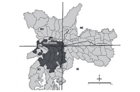
When analyzing spatial distribution of social classes in the city of São Paulo, we see that there is a general region in the city with an exceptional concentra-tion of higher income classes. this region is composed of several neighborhoods from the most different social classes, but most of these classes are concentrated in this region. We have called it “region with a Great Concentration of higher Income Layers”. In the case of São Paulo, it is the Southwest Quadrant shown in Figures 1 to 8. these figures show segregation of the highest income layers in the Southwest Quadrant based on a large variety of indicators. they have already been shown in other of our studies.1 Special attention should be paid to the map
show-ing the weather in the city (Climate - Figure 4). even the weather - which suppos-edly would not be the work of man - is milder in the Southwest Quadrant than in the rest of the city. this is due to the fact that this region has more parks and vegetation than the rest of the city (as well as of the metropolitan area). In the case of rio de Janeiro, the weather is not produced (as in São Paulo), but the highest income layers have always occupied more environmentally pleasant regions. Since the late nineteenth century, this region has been known as the city’s South Zone.
From the standpoint of a general region of the city, the study of the seg-regation of the highest income layers, or the richest (as opposed to the lowest income classes), enables the following articulations:
• With political aspects: through urban planning legislation, State ac-tion, especially as regards the transportation system (producer, as we shall see, of “locations”), or the location of the State apparatus. the Southwest Quadrant mentioned above is favored by both this system and these locations.
• With economic aspects: especially through the land market, land prices and real estate activity. these are much more dynamic in the Southwest Quadrant, where land has a higher price (other things being equal). real estate sections of major newspapers in any Brazilian metropolitan area shows the concentration of real estate activity in the respective areas of con-centration of higher income layers.
Figure 1 shows that according to a survey on Social Vulnerability (Folha
de S. Paulo, 23.Feb. 2002, p. C-3), the areas with “no or low” social
depriva-tion are concentrated in the Southwest Quadrant (these areas account for 22.1 percent of the population).
Source: Center for Metropolitan Studies (CeM) and Brazilian Center for analysis and Planning (CeBraP), in a survey commissioned by the Social assistance Secretariat of the City of São Paulo Government.
Figure 1 – Social vulnerability
Source: CePID/FaPeSP, Center for Metropolitan Studies (CeM) and Brazilian Center for
analysis and Planning (CeBraP).
Source: Center for Contemporary Culture Studies (CeDeC). the figure shows the ten districts which were considered the “…best places for young people.
Figure 3 - the best places for young people.
Sources: Municipal Civil Defense, NaSa, augusto José Pereira Filho, environmental atlas of the
Municipality of São Paulo and «Ilhas de calor nas metrópoles: o exemplo de São Paulo”.
Source: Secretariat of Development, Labor and Solidarity - PMSP.
Figure 5 - human Development Index (hDI).
Source: Origin and Destination Survey conducted by the Metro Company in 1977.
Source: Feldman (1996).
Figure 7 - Zoning 1972-2004. Single family residential areas (Z-1).
Source: Program for the Improvement of Information on Mortality in the Municipality of São
Paulo (Pro-aim). Prepared by: Municipal Planning Secretariat (SeMPLa) / Department of Statistics and Information Production (DIPrO).
Figure 2 shows the distribution of the black population in the city. It shows that most districts with the lowest black population are concentrated in the Southwest Quadrant. the black population (blacks and browns, in the ter-minology of the survey) in those districts does not exceed 10 percent (Folha de
S. Paulo, 21 Sep. 2003, pC-4).
Figure 3 shows that all ten districts considered as the “best places for young people” (score above 0.65 on a scale from 0 to 1: the higher the score, the better the region is for young people) are located in the Southwest Quad-rant. this survey considered “percentages of young people, teenage mothers and leisure trips, as well as population growth, homicide mortality, education, mobility index and family income” (Folha Magazine, 24 aug. 2003, p.6).
Figure 4 shows that the weather in the Southwest Quadrant is milder than in the rest of the municipality’s urban area. In this quadrant, temperatures vary between 25 and 29 degrees Celsius, while in the east Zone it ranges from 29 to 33 degrees Celsius. In the Southwest Quadrant the temperature is as much as 9 degrees lower than in the east Zone (Folha de S. Paulo, 15 Feb. 2004, pC-8). Our interpretation of the fact is that the Southwest Quadrant has more vegetation and parks and green areas than the east Zone, for example. that has nothing to do with altitude, as one might suppose. Most of the neighborhoods along the Pinheiros river and even distant from it such as Jardim américa and Jardim europa, alto de Pinheiros and Butantã, for example (all in Southwest Quadrant), are at the same altitude as most of the east Zone. Figure 4 shows the areas with the Mildest temperatures except, of course, for the mountain regions of the North Zone (Cantareira Mountain range) and the southernmost part of the municipality.
Figure 5 shows that the Southwest Quadrant concentrates all six districts with the highest human Development Index (hDI) in the municipality. On a scale from 0 to 1, in which higher values represent higher rates, these districts are: Moema, hDI 0.884, the highest in the municipality; Morumbi, 0.860; Jardim Paulista, 0.850; Pinheiros, 0.833; Itaim Bibi, 0.811; and alto de Pin-heiros, 0.801. Most of the districts with hDI above 0.651 were also located in this Quadrant. these districts had only 13.53 percent of the city’s population. among these, only three districts (Mooca, tatuapé and Santana ) were outside the Southwest Quadrant.
Figure 6 shows that the Southwest Quadrant concentrates all the districts with the highest average household incomes (over r$3,000.00 at current values at the time of the study), according to the Origin and Destination Survey con-ducted by Metro Company in 1997.
major-ity of the exclusively residential Zones (Zer) remained concentrated in the Southwest Quadrant.
however, in some districts in the North Zone most of the districts with the lowest rate of homicide per 100,000 residents (under 5) were located in the Southwest Quadrant.
With ideological processes through which the ruling class produces and disseminates ideas aimed at concealing the real processes of unequal production of urban space, which is not necessarily center versus periphery.
Since the latter is little known and addressed (despite its great impor-tance), we will talk more about it. Ideology dominates ideas of the majority of society, which accepts it as true. Ideology has to do with the understanding of who produces this type of thinking and for what purpose. We will give just two examples, always recalling that, without our approach to segregation by urban regions, they would be impossible. the first refers to the identification with “the city”, of that part of the city of interest of the dominant class. the second shows, in addition to this, another aspect that we will call “naturalization of social processes.” the first is illustrated by the following dominant idea: “the city of rio de Janeiro is squeezed between the sea and the mountains.” Noth-ing could be more false than that. this idea applies only to the South Zone. this zone (the zone occupied by the dominant class) is therefore identified with “the city”. thus, when the city government opens up a new street in the North Zone, it is benefiting the North Zone. When it opens a street in the South Zone, it is benefiting “the city”.
the second example shows the two cases mentioned above. the dominant idea is: the center of the city is “deteriorating”. Deterioration or decay is a natu-ral process that occurs only with living beings. this idea aims to hide the actual process labeled “decay!”, for which the dominant class is responsible but refuses to accept responsibility. the truth is that the so-called “decay” was due to the fact that this class has abandoned the center by removing from it their shops, offices, cinemas, etc., and even their homes, as is the case of São Luís avenue. It is precisely from the moment the center stopped being sponsored by the elites and began to be sponsored by the popular majority that the idea of
deteriora-tion emerged. and there is more. the fact that the majority has taken up the
the majority) it will be the center of the city. For over a century the high-income clientele has been abandoning the center of São Paulo and leaving their “left-overs” to the grass roots (to which the entire “old” center currently belongs). the displacement of the center of São Paulo - always towards the growth of the wealthiest residential neighborhoods - can be defined by the displacement of streets that synthesize trade and / or services for the elites. Initially XV de No-vembro Street (until the late nineteenth century) and then Direita Street, fol-lowed by Barão de Itapetininga Street and Paulista avenue and part of the end of augusta Street, until avenida Faria Lima, Marginal Pinheiros and Luis Carlos Berrini avenue. In the late 1940s, giving signs of “decay”, Direita Street turned into a traditional footing point for the black population on weekend nights.
the production of this ideology would be impossible without studying segregation by region of the city.
In previous occasions2 we have developed several considerations about
these ideas, which are part of a broader process of domination through urban space. Briefly, we can already say that this domination is due to the unequal distribution of advantages and disadvantages of produced urban space; these advantages and disadvantages relate especially to the manipulation, by the domi-nant class, of the time spent by the city’s residents in urban travel (travel times).
Urban structure and urban travel
the importance of segregation by region in understanding urban struc-ture is shown throughout this section, but we will highlight only aspects show-ing how:
a) ... the approach to segregation by region of the city enables relating it to the entire urban structure by focusing the inter-relationship of the produc-tion of urban space as a whole with the segregaproduc-tion of the residences of the rich-est (as opposed to those of the poorrich-est), with the segregation of their workplace and service places and domination through urban space.
b) ... it brings out possible new types of segregation, thus questioning its concept. this is the case of the workplace segregation highlighted in this text.
Segregation of employment: space
When we speak of employment segregation ( or location of jobs), we will be speaking of space.
Barra da tijuca as a place of malls, offices and services in general, and corpora-tions in particular. the same applies to all Metropolitan areas in Brazil, such as Porto alegre (Independência / Moinhos), Belo horizonte (Lourdes / Savassi), recife (Boa Viagem), Curitiba (Batel), Fortaleza (aldeota), or Salvador (Igua-temi region). this enables residents of these metropolitan areas to easily adapt these ideas to them.
Let us begin by noting that the location of tertiary jobs is of double inter-est to the population using them; in most cases (jobs that cater to the public at large), each point of employment in this sector is not only a workplace but also a place for catering to the population in their shopping and services. thus, the concentration of tertiary jobs is of a double interest, something that does not happen in the secondary sector, which does not cater to the public.
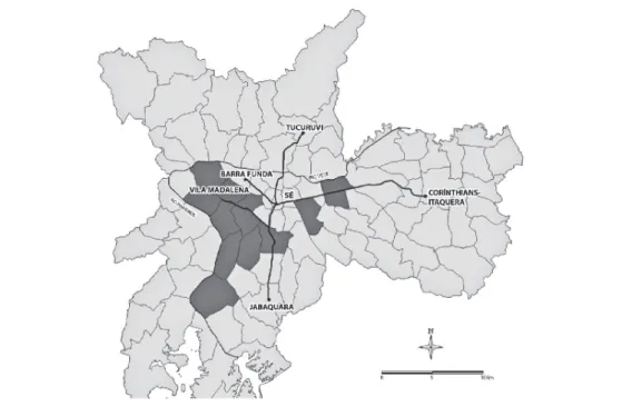
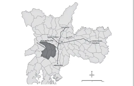
all our metropolitan areas have developed their area of Great Concen-tration of high Income Layers. as already shown, in the case of the Metro-politan region of São Paulo this area is its Southwest Quadrant (see Figures 1-8, especially Figure 1). Starting from the center, this Quadrant houses the neighborhoods of higienópolis, Pacaembu, Consolação, Paulista avenue, Vila Mariana, aclimação, Ipiranga, Sumaré, Perdizes, Vila Pompeia, altos da Lapa and Pinheiros, Jardins, Butantã, Morumbi and adjacent areas, Moema, Brook-lin, alto da Boa Vista, Granja Julieta, etc. For those who think that all of São Paulo is there, we remember that this region, including the popular neighbor-hoods contained therein, do not even account for 20 percent of the population of the Metropolitan region, and excludes the North and east Zones (up to Mogi das Cruzes) and the aBCD region, Mauá and ribeirão Pires, Guarulhos, Osasco, Carapicuíba, etc. It also excludes, although located outside the mu-nicipality but within the Southwest Quadrant or its edges (confirming our the-sis of single growth direction), the neighborhoods of Granja Viana, tamboré, alphaville and aldeia da Serra. In rio de Janeiro the segregation is even more pronounced. It’s famous South Zone, which stretches from Glória to recreio, including rocinha and other slums, account for only 10 percent of the Metro-politan region’s population.
residential segregation has been studied for decades. Let us just add to it the segregation of workplaces and shopping and service places. this approach is as much particular as it is fundamental. We will show the case of São Paulo, highlighting the concentrations of the workplaces of the majority of the popula-tion (the poorest) and of the richest minority.3
corporations, in banks and financial institutions, at the headquarters of the me-dium and large companies of various natures, doctor’s offices etc., as well as in retail. these jobs are concentrated in a single area, which is precisely where the homes of the richest are located, that is, the Southwest Quadrant of the city. the aforementioned figures show the segregation of the richest in this Quadrant ac-cording to several indicators.
the Southwest Quadrant of São Paulo concentrates not only the work-places of the richest, but also their shopping areas (malls), their primary and sec-ondary schools, judo or swimming classes (which often also entails trips by the mother), beauty salons, hospitals, parks, pet-shops, pubs and night life neigh-borhoods (Vila Madalena or Moema), physicians, fitness centers, dentists ... and even their churches and cemeteries! In other words, a whole plethora of services catering to the richest. thus, the richest minimize their traveling times to places of entertainment, leisure, shopping and services for all family members.
Most of the riches work in the tertiary sector. Most of the poor also work in the tertiary sector. the richest have produced a single area of concentration of their jobs (in the tertiary sector). however, this area also concentrates the jobs of the poorest. except that for these, it is far from being the only one.
the poorest have several areas of job concentration and (unlike the rich-est) both in the secondary (industry) and the tertiary sectors.
Before proceeding we wish to point out that when we speak of “work-place”, we are referring to the job of both the wife and the husband, in the case of the poorest, as well as of their adolescent sons and daughters (mostly in the case of the poorest).
Let us begin with the areas of concentration of tertiary jobs.
establishments in the tertiary sector are scattered all over urban space; it would be enough to think of the hundreds of shops, pharmacies, different repair shops, bars and bakeries, small shops, etc. scattered throughout the city, even in poor neighborhoods. there are, however, areas where these jobs are exception-ally concentrated.
although tertiary jobs are scattered, the dominant class, which prevails in these jobs, has produced a single area where they are more concentrated. this does not mean that the jobs of the richest prevail there; on the contrary. More-over, the dominant class has also produced the high concentration area of their houses, where their own workplaces, shopping and services are equally highly concentrated. as already mentioned, in this area there is also a large concentra-tion of jobs of the poorest (janitors, waiters, salespeople, clerks, assistants in general, less skilled workers, security guards, etc.), which actually prevail in this area.
not address here the importance of the “old” center to the urban structure. In the past it used to be a key element. today, we cannot say that for sure. Besides this center, there are also concentrations represented by retail and service sub-centers, all of which are popular, with a very small participation of the richest (sub-centers of Lapa, Pinheiros, Santo amaro, Penha, etc.) as well as the centers - all of them popular - which are the main centers of many municipalities in the Metropolitan region, such as the center of Santo andré, São Bernardo, Gua-rulhos, Osasco, Mauá, Poá, etc. all of them are not only employment centers but also retail and service centers. these are just areas of high concentration of tertiary jobs since, as already pointed out, these jobs are very scattered. this further complicates commuting for the poorest.
Let us now see the spatial concentration of industrial jobs.
the share of the poorest on the total number of industrial jobs is much larger than the share of the richest. In a medium or large size industry there are relatively few jobs for the richest, against thousands of jobs for the poorest. thus, an industrial zone is a zone of concentration of jobs for the poorest, but not a zone of concentration of jobs for the richest.
Most of those working in industries are poor. the opposite is not true, but the share of the poorest working in the industry is much larger than that of the richest. thus, the second source of employment, which is the industry, is much more important to the poorest than to the richest. therefore, the location of industrial areas is much more important to the poorest than to the richest who, incidentally, live far from these areas.
Contrary to the poorest, the richest do not compete for proximity to in-dustrial employment. thus, whenever possible, workers in these areas seek to live close to the industrial areas (especially aBCD, Guarulhos and Osasco).
the jobs of the poorest therefore are concentrated in several areas; several concentrations of tertiary jobs and several industrial areas. In the case of the richest there is only one area.
By heading the production of urban space, the dominant class heads not only its material and direct production, but also its value and price (by heading the real estate market). It also leads state actions on this space (urban legislation, location of the state apparatus, production of the transportation system, etc.) as well as the production of dominant ideas about it. all this, in fact, is what defines urban space.
Urban travel: time
When we speak of population traveling , we are speaking of time. We will be talking a lot about the space/time relation later on. We have already mentioned, however, that optimization of the time spent in urban travel (time) by urban residents is the most important factor explaining the organization of urban space and its role in the social domination it entails. the dominant class manipulates the production of this space, always prioritizing the optimization of their travel times.
View of Jaguaré Slum in the West Zone of the city of São Paulo
Based on the idea presented at the beginning of this paper - that urban space is not a product of nature but rather a produced product - we are trying to show how this space is produced and, in turn, produces certain trips by city residents,.
OD surveys always begin at the living place: one’s home: home/work-place, home/shopping areas, home/school, etc. Given workplaces of the poor-est are concentrated in several different places, what then happens with travels of members of the poorest households? the husband works in one location , the wife in a different area (in general not just far from her home, but also far from the husband’s workplace), their adolescent children work elsewhere and the kids go to a school or a daycare center that, if they are lucky enough, is close to their home or to the workplace of one of the parents. the possible existence of schools or daycare centers close to the home of the poorest is not enough to minimally alleviate their travel problems.
although the most important urban trips are those that connect the home to the workplace, there are other trips - typical of the OD surveys – which are also important; they are the home/school-home, home-shopping and services, and home-leisure trips. however, the importance of these other trips for the richest is very different from that for the poorest.
as among the richest, also among the poorest the home-workplace com-mute involves traveling for both the husband and the wife. But the similarities end there. among the poorest, the number of workers per household is higher, since the number of working adolescents is higher than in rich families. there-fore, their trips are not only more numerous but also more painful. this pro-duces a great impact on the poorest families, especially on the household econ-omy and on the health of its members (exhaustion and less hours of sleep, for example). For the poorest, the burden of traveling motivated by the children’s destination is small, as these children obviously do not have swimming, judo or ballet classes. they go with the mother to a daycare center or school, which, if they are lucky enough, may be close to the mother’s workplace, or they stay at home (with the grandmother or a neighbor), or walk to the nearby school. Moreover, home-shopping and home-services trips (shopping malls, gyms, parks, entertainment, movies, restaurants, banks, beauty salons, pet shops, etc.) are much more frequent among the richest than among poorest. therefore, for the richest, in addition to home-workplace commuting there are several other also important trips, although not as frequently as these. this does not happen in poor families.
for a varied of purposes)4 and also by the street/roads and transport systems
which, as we all know, have always favored the richest.5
the burden of urban civil works related to transportation - travel time - is enormous. Our political leaders - mayors and others – assign an outrageous pri-ority to civil works involving private transport at the expense of public transport. In any Brazilian metropolitan area the road system in the area of concentration of the richest is much better and bigger than in the rest of the city. In rio de Janeiro, for example, while 90 percent of the population is served by a lousy suburb train and bus systems, subway services are already being provided in Ip-anema and Leblon ( rich districts ) and soon will be reaching Barra da tijuca ( ( rich ouskirt). In São Paulo, billions of dollars are spent in an expressway urban ring, tunnels and expressways, while the Metropolitan region has a subway system smaller than that of Santiago capital city of Chile (where the cost of subway construction is very high due to the need for special protections against earthquakes), where metropolitan population is one-fourth of that of São Paulo.
Conclusion
the control of travel time is the most powerful force acting on the pro-duction of urban space as a whole, i.e., on the distribution of population and their workplace as well as shopping, services, and leisure Unable of directly in-fluencing time, man influences space production as a means of acting over time; hence the fierce social competition for the production of urban space and the importance of the transport system as an element of urban structure.
an important component of this mechanism is urban segregation which is a form of a spatial arrangement aiming at controlling travel times.
the paper shows how urban space is produced in Brazilian cities. It also shows the role of urban space in social domination, i.e. how travel times and population’s Origin and Destination points are produced.
In the Southwest Quadrant of the City of São Paulo there is a triple segre-gation of the richest: the location of their homes, their jobs (the tertiary sector) and also of their shopping and services places.
this text aimed to provide not only an overview of the social-spatial seg-regation typical of Brazilian
metropolitan areas, but also an idea of how their urban space is integrated into socio-economic inequality and its role in social domination.
the obscene inequality that exists in Brazilian society is expressed in the enormous segregation pattern of our metropolitan areas and medium size cities. the paper shows how segregation creates an exceptional burden for the poorest and an exceptional advantage for the richest.
urban space. In São Paulo, weather or urban space, are not a product of nature, but rather of human labor .
Notes
1 For high Income Layers not to be characterized - as the name says - only by income but also by other indicators, we repeat here (adding only from the map referring to homicides) figures already published on our website (<flaviovillaca.arq. br>) in the text As ilusões do plano diretor, and also on the same website, the research con-ducted along with Professor Silvana Zioni (O transporte sobre trilhos na região metropolitana de São Paulo), who is currently a professor at the Federal University of São Paulo.
2 See Villaça (2009, especially from p. 311) and Souza et al. (1999, p.221). For the relationship between segregation and ideology and political power, see also our texts on the Beltway in <flaviovillaca.arq.br> site.
3 In 1997, about 80 percent of the population belonged to families with incomes less than 20 minimum wages. although poverty has declined in recent years, inequality in wealth distribution, i.e., between labor income and capital income (not to be confused with the wage inequality mentioned herein) has changed little.
4 regardless of the dissemination of the idea (the discourse that conceals the reality) that “nowadays everyone has a car”, the truth is that a huge wealth inequality cor-responds also to a huge inequality in the use of private cars, cell phones, televisions, refrigerators, computers, etc.
5 the research conducted together with Professor Silvana Zioni (see note 2) shows that since it began operating, the Subway System has catered increasingly to people and neighborhoods in the Southwest Quadrant. the very priority given to the Subway at the expense of the modernization of suburban railways shows the priority given to the wealthier population. While in the Metropolitan area of São Paulo state and munici-pal authorities spend billions in civil works for the benefit of cars (tunnels under the Pinheiros river or under the Ibirapuera Park, and numerous smaller tunnels, beltway, enlargement of marginal roads, etc., in addition to the announced billion-dollar pro-jects such as the several kilometers-long tunnel linking roberto Marinho avenue to Immigrants highway, and new expressways for the city).
references
eNGeLS, F. Do socialismo utópico ao socialismo cientíico. São Paulo: Global, s. d. FeLDMaN, S. Planejamento e zoneamento. São Paulo 1947-1972. São Paulo, 1996. thesis (PhD) – School of architecture and Urbanism, University of São Paulo.
SOUZa, a. de et. al. Metrópole e globalização. efeitos do espaço sobre o social na metrópole brasileira. São Paulo: Cedesp, 1999.
abstract – the paper starts with the idea that urban space is not a product of na-ture but of man’s labor. It proceeds presenting a new way of focusing and analyzing urban segregation, using the city of São Paulo as a case study. through several social indicators, presented in 8 illustrations, it shows urban segregation in São Paulo. It sho-ws however that this new way also applies to any Brazilian metropolitan area. Impor-tant aspects shown by this new way are: on the one hand, the possibility it offers of analyzing the relationship between urban segregation of residences, working places and the overall urban spatial structure; on the other hand, the possibility of analyzing the relationship between urban segregation and the social inequality which prevails in Bra-zilian society as well as with social domination. It finally shows the relationship between human production of urban space and human production of time and the importance of the former.
Keywords:Urban space, Urban segregation, Social inequality, Brazilian metropolitan areas, Social domination.
Flávio Villaça is a retired professor of Urban Planning at the School of architecture and Urbanism, University of São Paulo (FaU-USP). @ – [email protected]