Conservation of natural
areas in São Paulo
N
eli
A
pArecidA
deM
ello
-T
héry
The territorial perspective of environmental protection
I
n São Paulo, like in great metropolises worldwide, environmental problems are a constant presence, especially as regards soil sealing and air and water pollution. The lack of infrastructure and the depletion of green areas contribute to worsen these types of pollution. Illegal occupations and out-lying areas are more dynamic than other areas in the city, and in the last ten years the average growth rate in the periphery was 1.50 percent, while in the down-town area it stood at only 1.02 percent (Silva, 2011). This growth consumed parts of the atlantic Forest and usually occurs in areas protected by law (sources, permanent preservation areas - hilltops or river banks, etc.) or on the edges of environmental conservation units.In this context, a concept of the utmost importance for understanding the territorial perspective of urban environmental protection is that of urban boundary (Marques & Torres, 2005). These are areas where population growth is greater than in the city itself and where environmental conflicts due to growth, especially invasions, are concentrated. In São Paulo it represents 30 percent of the popula-tion (five million people) putting pressure on the atlantic Forest (Cantareira for-est, margins of Billings and Guarapiranga dams). This border suffers from a high rate of population growth and migration, absence of the State and conflicts over space, in addition to exposing its residents to the risk of floods and landslides.
Considering that the urban territory is shaped by its people and is primar-ily a social, unevenly dynamic space marked by use conflicts and environmental degradation, causing the appreciation / depreciation in the value of different zones, wouldn’t the environmental problem be marked by the dilemma be-tween saving the environment or ensuring the right to housing? Can the right to housing endanger public goods? urban sprawl over water reserves and the atlantic Forest, necessary for the operation of the urban system itself, must be an essential element of urban environmental management.
In spite of these instruments, different actors flout the laws, as they know that control and supervision by the public institutions responsible are not suffi-cient to monitor each change, each transformation. Developers build new gated communities or resorts that devastate the last marsh areas and hillside forests, clandestine developers sell cheap lots to the low-income population, claiming future regularization; rural landowners pay no heed to requirements of legal Reserves (lR) or areas of Permanent Preservation (aPP).
Throughout human history, nature has been incorporated in different ways. The process of valuing nature and urban vegetation dates back to the ear-ly twentieth century, acquiring sometimes utilitarian, sometimes romantic and other times scientific features, which systematically oppose one another. Spa-tial forms are created, territories are defined with specific protection functions. Governments and societies find ways to include the topic in their local policies.
Stephane Héritier (2007) argues that the idea of protected areas such as national parks has become an asset for local development, because the actors (in-dividuals, associations, public and private decision-makers) are increasingly mo-bilizing around these original territorial shapes. These actors have a decisive role at the local level and, in this regard, stimulate or follow economic and social ac-tions, with the aim of improving the economic activity of territories and adapting them for the benefit of local residents. Increasingly numerous, the environmental services of parks are linked to local development objectives (Finger-Strich & Ghi-mire, 1997) or even, in an extremely utilitarian way, the strong idea of valuing the environment is translated into the use of these natural spaces for ecotourism purposes.
Martin Coy (2003) also contributes by analyzing the challenges of the urban planning and policy arising from urban fragmentation. Focusing on the city of São Paulo, the author contextualizes the emergence of pressure on the edges of urban and peri-urban protected areas through the configuration of the fragmented urban space (slums, low-income housing, upscale gated communi-ties). This fragmentation is differentiated and exposes to vulnerability, according to the conditions of marginal neighborhoods, occupations and slums (concen-trated on the southern, eastern and northern outskirts of the city). The concep-tual elements highlighted by the author contribute to addressing the process of fragmentation / anthropic pressure / risks to protected areas and losses for environmental conservation and conflicts between territorial public policies.
action can also induce social integration through land regularization and reha-bilitation of these segregated spaces.
Thus, the spaces are extremely unequal and may even have the interfer-ence (positive or negative) of areas aimed to environmental protection.
Multilateral institutions like the International union for Conservation of nature (IuCn) also offer important contributions. on an international scale, the IuCn has established six categories of protected areas,1 with no consensus on the criteria of this typology, since countries have different ways of classifying them according to locke & Dearden (apud Héritier, 2007). although contro-versial, its significance refers to the possibility of having an indicator that allows comparisons between the situations of different countries. How are these cat-egories presented in the metropolis of São Paulo?
IuCn, unEP and unESCo therefore consolidate the concept of natu-ral heritage, bring it closer to the ideas of public or common (collective) goods and strengthen the role of polycentric, multi-scale and multi-actor governance. although the debate became commonplace over the twentieth century, these concepts remain ambiguous, as the issue of ownership is present, unresolved.
according to 2010 nobel Prize winner Elinor ostrom (2009), polycentric and multi-actor governance is a way to solve the problems of common-use resources. The more complex a resource is in terms of types of goods and services offered, the more difficult is the establishment of institutional arrangements, especially in multi-scale aspects. according to her, the interaction between national, regional and local gover-nance can increase the likelihood of prioritizing the conservation of natural resources. orstrom believes that local citizens can create organizations with author-ity to decide on how to manage a resource (collective good), determining rules to overcome the problems of managing forms of access and use, as well as local control methods. There are still few examples of public management and na-tional laws incorporating the capacity of local actors to develop effective control rules and impose progressive sanctions. In the management of public goods (national or global), the role of smaller scales in the preservation of natural resources must be recognized, and therefore the author advocates the idea of polycentric governance and actions at different levels, in addition to active in-spection of local, regional or national strategies.
The theory of the tragedy of the commons allowed lambin (2004) to say
The process of environmental territorial restructuring
How do the planning and patrimonialization of natural conservation areas fit into this discussion?
Since the inception of the environmental conservation policy in Brazil, conservation units have been aimed to protect relevant natural features and en-sure the protection and conservation of their environmental heritage.2 Becker (1996) points out that these green territories have become an important ele-ment in the territorial and environele-mental restructuring process. However, ac-cording to some authors (acselrad, 1999; Héritier, 2007) there is a relationship of forces between defining protected areas and using them as a way of subtract-ing territories from local communities.
The ability of a country to ensure the environmental sustainability of its territory (target 7 of the Millennium Development Goals) is many times rep-resented by the increased number of these green territories. The proportion of surface covered by protected areas is one of the indicators used worldwide, which is calculated using all of these areas at the national level contained in the World Data Base on Protected areas (WDPa). The indicator enables assessing the protection status or protection trends over time. It has been widely applied on various scales to assess political response to lost biodiversity.
In recent years the federal government has adopted the strategy of estab-lishing conservation mosaics with different typologies, creating large areas with a specific environmental protection function. In 2010, the 310 existing federal units (full protection and sustainable use) covered an area of 75,467,815,705 hectares.
This connectivity strategy (regional ecological corridors, protection cat-egories according to the inter-ecosystemic diversity, transboundary protected areas, etc.) seems to be a core element for integrating protected areas into ter-ritorial planning and local development policies. How to assess the weight of these connectivity policies vis-à-vis other policies?
locally, the municipal government of São Paulo points out that municipal parks mean development, by adopting policies that stimulate the creation of municipal conservation units and linear parks, encouraging the connection and restoration of valley bottoms.
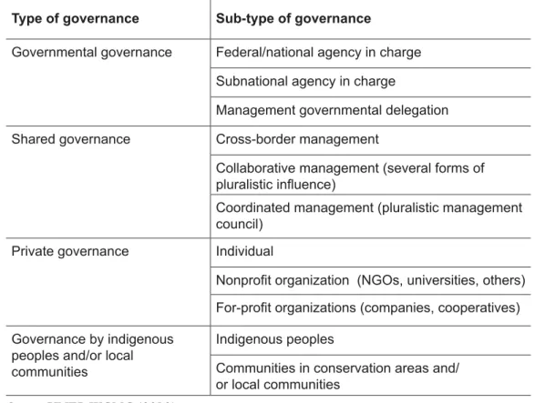
Table 1 – Governance matrix for protected areas, IuCn
Type of governance Sub-type of governance
Governmental governance Federal/national agency in charge
Subnational agency in charge
Management governmental delegation
Shared governance Cross-border management
Collaborative management (several forms of
pluralistic inluence)
Coordinated management (pluralistic management
council)
Private governance Individual
Nonproit organization (NGOs, universities, others) For-proit organizations (companies, cooperatives)
Governance by indigenous peoples and/or local communities
Indigenous peoples
Communities in conservation areas and/ or local communities
Source: unEP-WCMC (2010).
In the state of São Paulo, cooperation has taken place particularly through management, usually parity councils. In 2010 there were 65 state councils (47 integral protection units, 18 sustainable use units, including marine aPa).
But how do the populations react to these protected areas? In turn, how do these protected areas participate in the local dynamics outside their boundar-ies?
according to some authors like D. Goeury (in Héritier, 2007), the popu-lations feel deprived of the effective control of the planning and management of their territories. nGos try to establish participation in these processes, but their actions are modest; however, the main trend is for the central government to strengthen control by populations and territories. The author reminds us that for a long time relations between the managers of these areas and the popula-tions were marked by tensions and mistrust.
ter-ritorial systems. To Héritier (2007), “the way these arbitrations occur presents considerable interest for understanding the evolution of power relations within regions, which means going beyond national parks.”
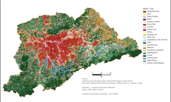
In this context, it is crucial to analyze the characteristics and situation of metropolitan land use according to the categories highlighted on the map in Figure 1 and, from this broader view, identify potential conflicts.
Figure 1 – Map of land use and occupation, Metropolitan Region of São Paulo.
urban land uses have characteristics and dimensions that differ from each other. The different purposes of land use complement one another to support human occupation, aiming to maximize the use of existing infrastructure and ensure the preservation of natural resources.
In the case of the metropolis of São Paulo, there are two opposite land use patterns: the concentration of forest areas on the outskirts of the south-southwest-west zone and the north (Cantareira State Park, Jaraguá peak), while the south-southeast, east, northeast and northwest zone is characterized by the reduced presence of forest (native or reconstituted), only in the Capivari-Monos aPa (buffer zone of the Serra do Mar Mountain Range), or the sources of the Billings and Guarapiranga dams. The urban sprawl follows the route of the main highways that converge to São Paulo. In the neighborhoods and municipalities northwest of the Metropolitan Region crossed by the anhanguera and Bandei-rantes roads, there are only remnants of forest, and fragmented urbanization has spread to steeper or risk areas.
Besides these areas, other smaller ones scattered by the clusters make up
Urbanized Area Slum Urban Facility Road Sanitary Landfill Dump Site Industry Vacant Lots Mining Exposed soil Other Use Vegetables, fruits and fowl Farm
Cleared Area Meadow Floodplain vegetation Reforestation Forest Holding Tank Water Mirror Border of Municipality MRSP – USE
Source:
Land Use and Occupation Map, Metropolitan Region of São Paulo São Paulo: Metropolitan Planning Company of São Paulo S.A., version 2, 2005
Projection: Universal Transverse Mercator Datum: SAD 1969 Fuso235
the Biosphere Reserve of the Green Belt of São Paulo. The connectivity be-tween them is the only possible configuration for the conservation of existing vegetation remnants.
Going back to international indicators, how do these relate to the Metro-politan Region of São Paulo?
Indicators relating to the amount of green area per capita are considered an excellent measure by the World Health organization (WHo). Values are expressed between 15 m² and 8 m² per capita, ranging between that interna-tionally accepted by the WHo (12 m² per capita), to the 15 m² per capita indi-cated by the Brazilian Society of architecture and urbanism (SBau) and 8m² per capita, according to the Brazilian Institute of Environment and Renewable natural Resources (IBaMa), only for municipalities located in the atlantic For-est. according to Takashi (2010), in the city of São Paulo 19 of the 31 boroughs have an index of green area per capita (IaV) below that recommended by the WHo. nine of these (47.4 percent) are located in the east zone, which led the program 100 Parks for São Paulo (2005) to establish more than 50 percent of the parks in this region.
The influence of intervention by transnational actors in the governance of protected areas can be identified in the innovations of management and funding methods and in the relations with the state. In this sense, the strategies (adopted in Seville, 1995) stimulated by the Biosphere Reserve of the Green Belt of São Paulo (RBCV) focus on consolidating the implementation of agenda 21 and symbolize the multiple scale action.
The overlapping of these international, state and municipal management scales materializes through unESCo, the State Secretariat of the Environ-ment and the Municipal Secretariat of Green areas and the EnvironEnviron-ment of São Paulo. Its importance in the largest Brazilian metropolis includes, besides its intrinsic forest-related aspects, especially improving mobility and air pollu-tion condipollu-tions, preservapollu-tion of plant and animal species, or as recreapollu-tion areas, representing different uses. The RBCV preserves important sites of the atlantic Forest biome, covering a large number of protected areas in different categories of protection of the environmental, cultural, historical, artistic and landscape heritage as well as indigenous lands.
aside from the multiple scales, how are apparently contradictory partici-pation and control initiatives coordinated?
on the one hand, international strategies reinforce the implementation of agenda 21 and training programs for the local population, assuming, in order to achieve their goal, two forms of action: using reserves as a model of territo-rial planning and sites for sustainable development experiments and applying the concept of reserve by integrating their functions, including conflict solving techniques.
of government programs proposed in the master plans of the cities that make up the metropolis, many of which are the result of social mobilization when agenda 21 was being developed.
among the main programs of the state government and of the city of São Paulo, the state and municipal conservation areas program adopts the territo-rial strategy of reordering whatever nature is left in the Metropolitan Region through corridors, to which linear and urban parks are associated.
The city of São Paulo: The presence of state parks and urban parks
How to make urbanization less unequal and more sustainable? To Vitte (2000, p.33), it is by meeting human needs without depleting the “natural capi-tal”. In this sense, the author uses the concept of urban planning and sustain-ability, highlighting among its categories those “related to the provision of ser-vices related to leisure and recreation, protection of natural and cultural heritage and protection of natural and aesthetic landscapes”, which can be represented by the urban parks existing on the borders of the municipality São Paulo.
To acselrad (1999, p.86), urban sustainability should maintain a proposal of adaptive reproduction of urban structures,
whose focus is the readjustment of the legitimacy bases of urban policies, seeking, in turn, to recreate the urban design according to the efficiency or equity model. In both cases, the city will be at stake as a space of long-lasting construction of political pacts capable of reproducing, over time, the conditions of its legitimacy. By promoting an environmental articulation of the urban, the discourse of sustainability of cities updates the clash between the “technifica-tion” and politicization of space, incorporating, this time, given the consider-ation of the temporality of urban practices, the confrontconsider-ation between technicist and politicizing representations of time, within which projects focused on the simple reproduction of existing structures or on strategies that cultivate in the city the space par excellence of the invention of social rights and innovations can coexist simultaneously.
Thus, upgrading the protected areas existing in the Metropolitan Region and increasing their number or connectivity is now part of the governmental discourse.
The state conservation units within the region are state parks alberto loefgren (Horto Florestal), Cantareira, Jaraguá, Serra do Mar, das Fontes do Ipiranga, the ecological parks of the Guarapiranga and Tietê rivers, the environ-mental protection areas Floodplains of the Tietê River, Iguatemi Forest, Villa-lobos Park and Água Branca Park.
add to these protected areas the urban parks and parks under the 100 Parks program, which essentially prioritize the potential landscape. However, what are the duties and attributes of an urban park? The main elements for an urban park are its physical geography, its urban function and the relationship with its surroundings, according to Kliass (1993). Thus, the questions raised by Héritier (2007) about the reaction of populations located around these areas and how these areas participate in the local dynamics, are extremely relevant. according to Kliass (1993), these parks are not used effectively by the surround-ing population, and one of the strategies of the municipality was to establish the Municipal Parks Management Council, as a way to bring government and community together.
as the vegetation has been used as a parameter for assessing the quality of life, the characterization of the landscape of streets, squares and parks helps to give man a notion of space and enhance the physical environment of the city, giving it a contemplative recreational contact with nature (Furlan, 2004). Its importance is such that it has been integrated into the guidelines of the munici-pal Green areas policy (Municimunici-pal law no. 13430/2005), which treats vegeta-tion as an integrating element in the urban landscape, incorporating significant surfaces to the Green areas System of the municipality, expanding afforestation of streets, creating tracks connecting squares, parks or green areas, and aims to recover degraded areas of landscape and environmental importance.
The Strategic Master Plan created the Green areas System (art. 131) formed by the set of public or private wooded and landscaped spaces required for maintaining urban environmental quality. The same plan introduced the linear Parks, focused on recovering valley bottoms and their landscape, and the Program for the Environmental Recovery of Water Courses and Valley Bottoms, in order to consider the Structural Hydro network as structuring element of urbanization, thus restoring the environmental logic of the hydrographic basin.
Contemporary green area plans in the city of São Paulo are old. Between 1967 and 1969, a plan was developed classifying green recreation areas. In 1984 the Master Plan indicated that there were no more areas for the establishment of urban parks. In 2002 the Strategic Master Plan established the policy of ex-panding the green areas to improve the rate of green area per capita (art. 131). Between 2005 and 2010, the municipal assessment showed an increase of 100 percent in the number of municipal parks (from 34 to 67). all 31 boroughs and 96 city districts have a park either implemented, under implementation or planned.
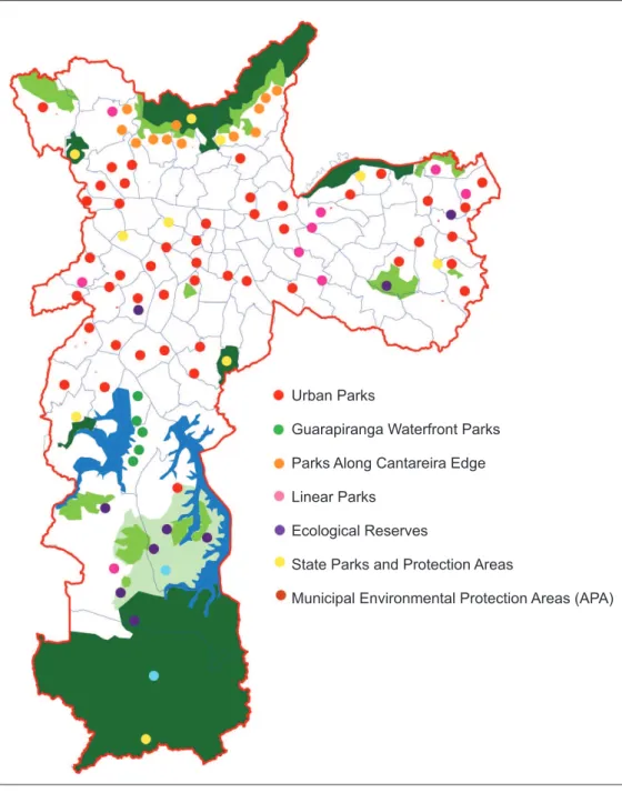
(PRnP). The map in Figure 2 shows the public parks and protected areas lo-cated in the city of São Paulo.
Source: Municipal Secretariat of Green areas and the Environment (2011).
Figure 2 – Public parks and protection areas located in the city of São Paulo.
There is nothing new about the assertion that the expansion of the pe-riphery is an indicator of the influx of lower-income people to illegal settlements with no infrastructure, thus reinforcing the vicious cycle of poverty. These occu-pations are in places where farms and ranches were originally located, especially
Urban Parks
Guarapiranga Waterfront Parks
Parks Along Cantareira Edge
Linear Parks
Ecological Reserves
State Parks and Protection Areas
in the foothills on the south side of Cantareira and in the dams region south of the city of São Paulo, stretching to watershed areas.
Besides the IaV, the protection of supply water sources is another urban parameter of the Strategic Master Plan, which provides for sparsely populated occupations and controlled expansion of infrastructure networks for these areas.
Its importance to the maintenance of the urban system itself exacerbates the critical issue of supplying, with quality water and at sufficient quantities, the nearly 20 million people, based on the realization that all watershed areas are targets of the expanding urban sprawl of the municipalities characterized by the displacement of poor populations to outlying areas. only 50 percent of the water consumed in the MRSP is produced by sources existing in the region, particularly the Billings and Guarapiranga dams and the upper Tietê River Sys-tem; the rest is imported from the Piracicaba River Basin, 70 km from SP. The Capivari-Monos aPa was created with the goal of maintaining the water quality of the spring, integrating the Biosphere Reserve of the Green Belt.
Despite the legal prohibition, the area of the Billings dam is occupied by high densities, with new service and industrial poles. With the change in land use, production farms have become leisure farms and / or spaces characterized by the absence of housing programs.
Thus, the public action shows a discourse that opposes its action: it insists on expanding protected areas in the form of urban parks, but is unable to keep away from occupations or even from regular neighborhoods, the sources that are fundamental to supply water to the city.
Conclusion
From the standpoint of public policy, public actors face the challenge of de-ciding what to do with populations that invade conservation areas. or, rather, use the local discourse of meeting the needs of homeless populations, thus impairing management itself and the capacity for collective actions aimed at territorial en-hancement, through the mobilization of the populations of these protected areas. Managers try to meet the challenges faced by the urban population through housing, rehabilitation or conservation programs. Public conservation policies (municipal, state or federal) are facing these serious challenges. The serious problems of housing, with the growth of precarious housing, spatial fracture, rapid socially contrasted suburbanization, threats to the environment, which is as fragmented as the city itself, require efforts, not always promising, to reduce the impact of these policies on protected areas.
Housing policies, programs for creating or improving popular neighbor-hoods or improving slum areas, decentralized action and the very subliminal
by the housing or conservation problem. In turn, public managers have incor-porated in their discourses and actions the idea that environmental protection areas, in their different configurations, should be part of the local development model by providing environmental services.
Public policies cannot be a source of conflict; on the contrary, they need to be articulated, to be cohesive to get the populations to engage and defend environmental quality rather than opposing it. Besides improving governance for the engagement of the populations, it should also serve for people to see the green areas as important elements for maintaining the operation of the urban system and the environmental quality of their territories.
In this context, it is imperative to break the ongoing process of expanding the urban frontier towards protected areas. These are part of the prerogatives of the new urban environmental protection model.
notes
1 (i) Integral protection: restricted natural reserve / natural forest area; ii) ecosystem conservation: national park or equivalent; iii) conservation of natural features: natural monument; iv) conservation through active management: habitat / species manage-ment area; v) conservation of landscapes and seascapes and recreation areas: protected landscapes and seascapes; vi) sustainable use of natural ecosystems: protected area with management of natural resources.
2 The national System of Conservation units was created only through Federal law. 9985 of 18 July 2000, regulated by Decree 4340 of 22 august 2002; however, since 1965 regulation was introduced through the Forest Code, and the expansion of the typology of Cu was established by ConaMa.
References
aCSElRaD, H. Discursos da sustentabilidade urbana. Revista Brasileira de Estudos Urbanos e Regionais, Campinas, n.1, p.79-90, May 1999.
BaRTalInI, V. Parques públicos municipais de São Paulo: a ação da municipalidade
no provimento de áreas verdes de recreação. São Paulo, 1999. Thesis (PhD in archi-tecture and urbanism) – School of archiarchi-tecture and urbanism, university of São Paulo. BECKER, B. Tendências de transformação do território no Brasil. Vetores e circuitos.
Território, laget, uFRJ, v. 1, n. 2, p. 5-19, Jan./July 1996.
BuRGoS, R. Parques públicos urbanos na metrópole paulistana: concepção e uso na
produção do espaço urbano. São Paulo, 2003. Dissertation (MSc in Human
Geogra-phy) – School of Philosophy, letters and Human Sciences, university of São Paulo. CoY, M. The fragmentation of the Brazilian city. Recent tendencies and challenges for urban policy. Iberoamericana, II, v.1, p.111-28, 2003.
FInGER-STRICH, a. S.; GHIMIRE, K. B. Travail, culture et nature. le
FuRlan, S. Paisagens sustentáveis: São Paulo e sua cobertura vegetal. In: CaRloS, a. F. a.; olIVEIRa, a. u. Geograias de São Paulo: a metrópole do século XXI. São Paulo: Contexto, 2004.
HÉRITIER, S. les parcs nationaux entre conservation durable et développement local,
Géocarrefour, v.82, n.4, 2007. [En ligne], mis en ligne le 6 juin 2008. available at:
<http://geocarrefour.revues.org//index2992.html>. access on 3 July 2008.
KlIaSS, R. Parques urbanos de São Paulo e sua evolução na cidade. São Paulo: Pini,
1993.
laMBIn, E. La Terre sur un il. Paris: Pommier. 2004.
ManToVanI, M.; GlEZER, R. (org.) Parques urbanos e meio ambiente: desafios de
uso. São Paulo: official Press, 2006.
MaRQuES, E.; ToRRES, H. São Paulo, segregação, pobreza e desigualdades sociais.
São Paulo: Senac, 2005.
MunICIPal SECRETaRIaT oF GREEn aREaS anD THE EnVIRonMEnT.
Provides information on parks located in the metropolitas regions of São Paulo.
availa-ble at: <http:// www9.prefeitura.sp.gov.br/sitesvma/100_parques/regiao/index php?p=18>. acess on 22 jan. 2011.
olIVEIRa, P. T. Sistemas de indicadores ambientais: um modelo para o
monitoramen-to de parques urbanos. São Paulo, 2007. Dissertation (MSc) – Institute of Technolo-gical Research, university of São Paulo.
oSTRoM, E. Gemeingutermanagement – eine Perspektive fur burgerschaftliches En-gagement [Governing a Commons from a Citizen’s Perspective]. Wem gehort die Welt? Zur Wiederentdeckung der Gemeinguter. Ed. Silke Helfrich, 218-228. Munchen:
oekom Verlag, 2009.
SaSSEn, S. The ecology of global economic power: changing investment practices to promote environmental sustainability. Journal of International Affairs, new York, v.58,
n.2, p.11-33, Spring 2005.
_______. Bridging the ecologies of cities and of nature. In: THE 4th InTERna-TIonal ConFEREnCE oF THE InTERnaInTERna-TIonal FoRuM on uRBanISM (IFou): The new urban Question – urbanism beyond neo-liberalism. amsterdam, Delft, 2009.
SIlVa, É. T. da. Censo 2010: as metrópoles na dinâmica demográfica. available at:
<http://www.observatoriodasmetropoles.ufrj.br>. access on 16 Feb. 2011.
TaKaSHI, M. M. Parques urbanos no município São Paulo: análise das políticas públicas
para sua implantação. São Paulo: School of arts, Sciences and Human Sciences, un
versity of São Paulo, 2010. (Introduction to Science).
unEP-WCMC. Data Standards for the World Database on Protected Areas,. unEP-
WCMC. 2010.
VITTE, C. de C. S. Planejamento urbano, sustentabilidade urbana e qualidade de vida: considerações sobre o significado de cidade e de cidadania no início do século XXI. In: KEInERT, T. M. M.; KaRRuZ, a. P. (org.) qualidade de vida: observatórios,
AbsTrAcT – The central argument of this paper is the connection between
environ-mentally protected areas, their importance in the context of a world metropolis and the conflicts arising from growth of the metropolitan population. In cities like São Paulo, the presence of vegetation is an asset, an indicator of quality of life taken into account by the real estate market. Thus, the first aim of this paper is to analyze the territorial perspective of environmental protection, referring to the legal framework of the great metropolis and its territorial planning. In view of these elements, the second part analyzes the territorial restructuring strategies adopted in public policies and their relationship to the international level (biosphere reserve of the green belt of São Paulo and the biosphere reserve of the atlantic Forest). The third section analyzes the state and urban parks within the territorial policies.
Keywords: Conservation, Territorial restructuring, São Paulo.
Neli Aparecida de Mello-Théry in an associate professor at the School of arts, Sciences