GENERATING ORIENTED POINTSETS FROM REDUNDANT DEPTH MAPS USING
RESTRICTED QUADTREES
M. Rothermel∗
, N. Haala, D. Fritsch
Institute for Photogrammetry, University Stuttgart, Germany - [email protected]
KEY WORDS:Matching, Surface, Three-dimensional, Point Cloud, Fusion, Triangulation
ABSTRACT:
In this article we present an algorithm for the fusion of depth images derived by dense image matching (DIM). One key idea of our algorithm is to generate a 2D triangulation for each available depth map in the image sequence using a restricted quadtrees (RQT). On the one hand this guaranteesmatching triangulations, on the other hand this creates the possibility to reduce points in the noise range not contributing to the geometry in a controlled manner. By vertex decimation computational efforts in subsequent processing steps are eased. In order to reduce IO overhead, the algorithm is designed in an iterative way: an initial triangulation is lifted to 3D space and, if pixel footprints are comparable, updated using depths of the subsequent map in the sequence. Previously not observed surface regions or surface patches observed only with adverse precision are removed from the existing model and updated by more appropriate triangulations. Thereby differences in scale across depth maps are handled which is particularly important to preserve details and obtain surfaces with the best reconstruction geometry. To remove outliers visibility constraints are forced. The input is overlapping depth images and their poses in space, the output are point coordinates representing the surface, their respective normals and to some degree spatial neighbourhood information of points represented as a non-watertight mesh. The performance of the algorithm will be evaluated on a close range and a oblique aerial dataset.
1. INTRODUCTION
Image based surface reconstruction has been a vivid research area in the last decades. Advances in both sensors and algorithms en-able reconstruction of high quality point clouds providing depth information for almost every pixel at accuracies up to ground sampling distance (GSD) level (Haala and Rothermel, 2012). To guarantee completeness, robustness and precision, image sets for the purpose of 3D reconstruction are typically collected with high redundancy (high image overlap). Particularly the class of im-age based multi-view reconstruction systems (MVS) (Seitz et al., 2006) which generate one or more depth maps per frame face one problem: spatial information of the same surface point is recon-structed multiple times within the image sequence, which leads to a significant amount of redundant observations varying in pre-cision and reliability. The reason for variances in reconstruction quality of depths across stereo models are manifold and comprise
• Differences in image scale
• Differences in the number of observations available across the views used for depth reconstruction at image matching / forward intersection stage
• Differences in ray intersection angels across views
• Matching errors due to image blur, fronto parallel effects, pixel locking effects, etc.
To reduce data, removing erroneous depths and exploit redun-dancy an adequate fusion strategy is required. Based on the cleansed data subsequent meshing algorithms can be applied.
Some MVS systems avoid the depth map fusion step by link-ing surface points directly at the matchlink-ing stage. Beside the ex-pandability of the integration step these algorithms take advan-tage of multi-photo consistency measures. Starting with a sparse
∗
Corresponding author. This is useful to know for communication with the appropriate person in cases with more than one author
set of points, PMVS (Furukawa and Ponce, 2010) optimizes posi-tion and normals of surface patches based on multi-photo consis-tency. Iteratively the surface is grown by propagating patches to proximate regions. If no foreground / background information is available, the final oriented point sets are meshed using Poisson Reconstruction (Kazhdan and Hoppe, 2013) followed by a re-finement step evaluating photo consistency of each mesh vertex. Starting with an even more coarse mesh produced by Delaunay triangulation of SIFT (Lowe, 1999) feature points the approach proposed by (Hiep et al., 2009) grow / reconstruct detailed sur-face using variational optimization of a global cost function based on multi-view consistency measures.
the latter can serve as input for subsequent meshing techniques as Poisson Reconstruction (Kazhdan and Hoppe, 2013).
A purely geometric algorithm for depth map merging was pro-posed in Polygon Zippering (Turk and Levoy, 1994). The method generates triangle meshes by simply constructing two faces from four adjacent depth estimations. Suspicious triangles are removed by evaluation of the triangle side lengths. After alignment of meshes, redundant triangles are removed from the boundaries of single patches and remainders are connected. However, redun-dancy is not exploited and visibility constraints are not imple-mented. Perhaps most similar to our approach is a method pre-sented for the fusion of noisy depth maps (Merrell et al., 2007) in real-time applications. Proximate depths maps are rendered in one reference view. Redundant depths per pixel are checked for geometric consistency and are filtered using occlusion and confi-dence checks. After consistent depth estimations are averaged a mesh is constructed on the depth maps using quadtrees and lifted to 3D space. In contrast, we emphasize image scale within our fusion method and prefer a restricted quadtree for meshing.
Region quadtrees are data structures spatially separating 2D space. Starting from an initial quad (node), each quad is recursively split into four sub-quads (sub-nodes) until a certain level is reached or each node satisfies a specific criteria. Quadtree triangulations of 2.5D elevation data was covered in multiple works, mainly in the field of computer graphics, for regular and irregular data points, see (Sivan and Samet, 1992), (Pajarola et al., 2002) and (Pajarola, 2002) for an excellent overview. In (Pajarola, 1998) a special type of this structure, a restricted quadtree (RQT), was used for the triangulation of digital elevation data for the purpose of ter-rain visualization. The idea is to build a RQT on regular 2.5D height data raster from which then a simplified triangulation can be derived. One of the key properties of RQTs is the option to extract matching triangulations from regular grids, meaning that resultant surfaces represented as triangle meshes are crack-free. Moreover, vertices of such triangulations are guaranteed to fulfill specific error criteria, or in other words, allow to discard vertices (linked to depth estimations) satisfying this criteria. We exploit this property to discard depth estimations not contributing to the geometry at an early stage of the fusion process.
A large portion of depth map fusion builds up on volumetric range integration of depth maps (VRIP) (Curless and Levoy, 1996). Typically a signed distance field is computed on a (multi-level) octree structure by projection of depth estimations from which then a triangulation can be derived for example using the March-ing Cube algorithm (Lorensen and Cline, 1987). In a similar way (Zach et al., 2007) and (Zach, 2008) reconstruct a zero level set in voxel space. Then a surface is extracted by minimizing a global energy functional based on the TV-L1 norm, claiming smoothness and small differences to the zero level set. Although giving impressive results, the computational effort and memory demands are significant. Moreover, depth samples across views possessing different scales is challenging for VRIP approaches. One example addressing this issue is the scale space representa-tion presented in (Fuhrmann and Goesele, 2011). They build a multi-level octree holding vertices at different scales. Triangles from the depth maps are inserted according to their pixel foot-print. This way a hierarchical signed distance field is generated.
lation of an initial depth map. The error criteria is formulated using local pixel footprints as a measure of precision. If a spe-cific depth value is assumed to be located in the noise band it is not considered for further processing. The compressed sub mesh is then lifted to 3D space and builds the initial part of the model state. Iteratively the model is projected to the next depth map us-ing depth bufferus-ing as well as frustum- and backface cullus-ing. If the pixel footprints (the image scale) of existing vertices and map values are comparable the existing surface points are refined. If the scale differs, the most accurate surface representation is cho-sen. Surface patches not contained by the model are triangulated and added. Note that this is a purely geometric approach although regularization was applied during DIM process.
2. METHODOLOGY
In this chapter we describe the single steps performed to extract oriented point sets from a set of oriented depth maps. Each avail-able map is initially filtered to remove obvious errors introduced by the DIM process. This is discussed in section 2.1. In section 2.2 properties of RQT and extraction of matching triangulation from depth maps using an error criteria based on the pixel foot-print is explained. In section 2.3 we describe the iterative fusion of depth maps and triangulations to get the final set of oriented points.
2.1 Filtering of Depth Maps
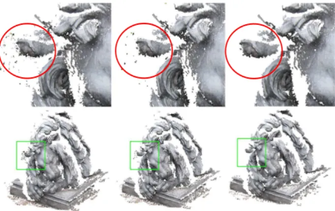
Prior to the actual meshing process the single depth images are fil-tered in order to remove spurious depth values. Although multi-view approaches may result in rather clean point clouds not all erroneous elements can be detected based on the evaluation of geometric and/or radiometric consistency across multiple views. One major problem, for example, are regions of object borders in combination with low-textured background (see the red cir-cle in 1). In these parts pixel consistency measures are not dis-tinctive and depth estimation is mainly powered by smoothness constraints. As a result edges are over-matched what cannot be reliably detected by consistency constraints across the images. These erroneous depths are typically represented by small-sized pixel patches. In order to filter these elements we compute the connectivity of each pixel within its local neighbourhood. This measure will be referred to as support in the following text. In-spired by the path-wise accumulation process of SGM, for each pixelx(x, y)the support is computed by the evaluation of con-sistency with its proximate pixels along 16 image paths.
S(x(x, y)) = 16
X
i=1
si(x(x, y)) (1)
The pixel-wise support values are computed evaluating subse-quent pixelsxn,xn+1along a pathias
si(x) = ∞
X
n=0
Figure 1: Point clouds corresponding to the filtered depth maps for different thresholdst. Figures in the upper row are detailed views of the area depicted by the green rectangles. Left:ts= 0; Middle:ts= 21; Right:ts= 41
therebyndenotes the offset with respect toxalong the path di-rection.T()is a operator evaluating to 0 or 1 according to
T(xn,xn+1) =
(
1 for d(xn), d(xn+1) valid
0 else (3)
If the final supportS(x(x, y))is below a certain valuetsits depth will not be considered for further processing. Figure 1 displays results for different thresholdsts. The red circles mark areas of erroneous depths due to overmatching. For a threshold ofts= 41
we got overall satisfying point filtering within our tests. We used this threshold for all of our experiments.
2.2 2.5D Mesh Extraction from Depth Maps using Restricted Quadtrees
Generally there are two different approaches for the RQT con-struction. The bottom-up strategy initially starts by defining nodes on the lowest (full resolution) level. Then, each node is evaluated based on quadtree and error criteria. The quadtree criterion as-sures that side lengths of proximate grid cells are the same, the half or the double. This property allows to obtain matching trian-gulations. The error condition, typically the approximation error describes to what extend geometric errors are introduced if the particular node is removed. If these two conditions are met, nodes are fused and higher level nodes are examined. The major draw back of this approach is that error conditions can not be guaran-teed. Although conditions are fulfilled for local evaluations the errors accumulate over multiple levels.
This drawback can be overcome by a top-down construction strat-egy. Thereby initially the raster data is represented by a single node. Nodes are added recursively if error criteria are not ful-filled. However, compared to the bottom-up methods the imple-mentation is more sophisticated because when adding a node on levellalso updates on higher levelsl+nmight be necessary to maintain the restricted quadtree structure. An efficient implemen-tation is given in (Pajarola, 1998) which is based on dependency graphs. Each node depends on two other nodes from the same or the next upper level. Recursively, in a top-down manner, all nodes are checked for error criteria based on their two dependent nodes and activated if these are fulfilled. If a node is evaluated to be a part of the triangulation then its dependent nodes and their dependencies have to be activated too. From the set of finally ac-tivated nodes a matching triangulation can be extracted. For more detailed information of implementation the reader is referred to the original publication.
Figure 2: Visualization of the error criterion, point candidate red, dependent node points blue. Left: error criteria is not fulfilled, point candidate is inserted to triangulation. Right: error criteria is fulfilled, point candidate is not inserted to triangulation.
In this work the concept of RQT is applied for constructing meshes from depth maps generated by multi-view matching systems. The goal is to extract robust normals from these meshes on noisy depth estimation whilst preserving as much as possible geometric information. The RQT approach holds the error criteria for each node and gives us the option to extract normals in a controlled manner. For the meshing of elevation data presented in the origi-nal work approximation errors are computed in object space and added to the triangulation if larger than a constant thresholdǫ. We base our dynamic error criterion on the pixel footprint assuming that precision of depth maps linearly decreases with the depth (and therefore the GSD). Letnbe a node with the depthd(x, y)
and its dependent nodes n1, n2 withd1(x, y)andd2(x, y) re-spectively. Each depth point is assumed to be measured with an uncertainty ofǫ = gsd∗tq. The nodenis inserted to the tri-angulation if it is not contained by the local noise band which is defined byd1±ǫ1andd2±ǫ2(figure 2). Hence, a depth value is considered to contribute to the geometry if
d−ǫ >(d1+d2+ǫ1+ǫ2)
2 or
d+ǫ <(d1+d2−ǫ1−ǫ2)
2
(4)
The pixel footprints are approximated by projecting the pixel pitch onto the fronto-parallel plane at depthd,d1,d2. Within the mesh generation step we discard triangles made up by vertices varying by more than six times the local pixel footprint in depth. Dependent ofǫthe number depth measurements can be reduced in a controlled way. For an example of the quadtree structure see figure 3. Note that vertices not representing actual structure but local noise can be removed.
2.3 Model Fusion
In this section we discuss how we fuse estimations of all avail-able filtered maps to generate a non-redundant point set and the respective normals indicating the surface orientation. Our over-all modelM(i)at the iteration stepiis represented as a set ofi sub-modelsSi. Each sub model contains vertices and respective faces of one depth mapDi. To update the model by a depth map Diwe iteratively perform the following four steps:
1. Generate virtual vertex imageViand virtual face imageFi by projecting vertices and faces of all sub models Si for i∈[0, i−1]
2. Fusion of vertices contained in the depth mapDi and the model vertices stored in imageVi.
Figure 3: Meshes generated by quadtree approach in dependence ofǫ. Upper: Uncompressed triangulation forǫ = 0. Middle: RQT triangulation withǫ= 1.2. Lower: Overlay of shaded sur-facesǫ= 0(green) andǫ= 1.2(orange)
4. RQT meshing ofDiand insertion toM
For the generation ofViwe skim all the models contained byM and project them to a virtual view corresponding to the depth im-ageDi. Thereby we use backface and frustum culling as well as z-buffering. If a vertex is successfully projected, its pointer is stored toVi. This way pointers to all vertices observable from the ith frame are stored. With the same intention, all faces ofM are projected to the virtual imageFi. This way a set of adjoin-ing faces for each vertex ofViis derived. Since each vertex can touch a maximum of nine facesFihas to be designed as a three dimensional data structure. The virtual face image is later used to invalidate redundant or obsolete depth estimations inDi.
Once the virtual views are generated, the depth estimationsdi(x, y)
in the current depth imageDiare fused with depthsdm(x, y) im-plied by the model verticesvi(x, y)stored inVi. If for the same coordinates(x, y)only one of the depths diordmis available no fusion is carried out. Otherwise the depths are checked for geometric consistency. We evaluate consistency by means of the local pixel footprintspiof depth image pixel andpmthe footprint of the model depth. Depending on the factortcwe consider the two candidates to be consistent if
|(di−dm)|<(pi+pm)tc. (5)
In this case a counter expressing the reliability of an vertex is in-creased. If equation 5 is not fulfilled the visibility is verified. In
tiating two cases. Paying respect to scale differences we again evaluate the local footprintspianpm. If the scale is comparable, the vertex coordinates are projected to the depth map and a depth is bilinearly interpolated. The model vertex coordinates are up-dated taking into account the number of detections and footprints. Given that scale differences are more significant the surface point providing the smallest resolution is kept and the other is invali-dated.
In the course of the fusion process, all model vertices which should be removed as well as the values in the depth maps which should not be considered for triangulation are identified. Subse-quently, model vertices are erased by scanning the vertex lists in all sub modelsSi. Moreover, faces based on these obsolete ver-tices are removed. Invalidated depths in the current depth map Di are not considered for triangulation. However, in order to also remove pixels corresponding to faces between the the inval-idated depths, image areas covered by projected faces have to be invalidated. ThereforeFi(x, y)at all invalidated depthdi(x)y are scanned and pixels covered by the triangles are marked in-valid. Note that this is a rather conservative approach of adding new depths since image regions of up to nine adjoining triangles are invalidated per depth.
3. RESULTS 3.1 Close Range Dataset
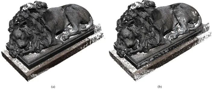
We use the lion data set ( publicly available at (Jancosek and Pa-jdla, 2008)) to evaluate the proposed algorithm regarding perfor-mance in presence of scale variances, advanced 3D structure and occlusions. Depth maps for the 56 images were generated using SURE (Rothermel et al., 2012). Then the resulting depth images were fused using two different thresholdsǫ= 1.0andǫ= 1.2for the RQT construction. In our experiments we found these values to be a good trade off between data reduction and preservation of geometry. Moderate changes ofǫeffect point density signif-icantly. The number of original depths estimations was reduced from62.9million to11.7and5.7million points respectively. As expected, the number of points for largerǫis smaller. However, as can be seen in figure 4, rather complete surfaces can be obtained. As shown in figure 6 for water tight Poisson reconstructions us-ing an octree level of11, the visual appearance is rather similar. The surface in large parts possesses the same noise levels and the similar amount of detail. Obtained reconstructions are not con-sistent in some parts, meaning triangles are overlapping or are located in front of each other. This is mainly due to the fusion of depths representing slanted surfaces. To avoid this, we plan to incorporate the available normal information in future. Figure 5 depicts the color coded normals of the resulting points. Except for few outliers, extracted normals are extracted reliably, which is particularly important for the subsequent extraction of water tight surfaces.
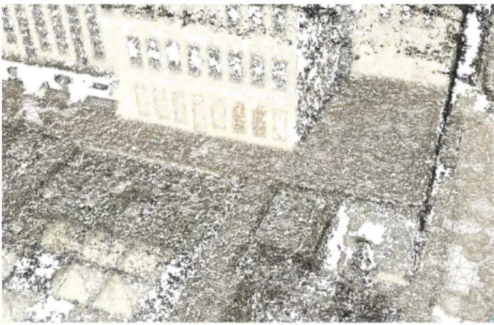
3.2 Oblique Airborne Dataset
(a) (b)
Figure 4: Resulting oriented points of the lion data set. (a): RQT error thresholdǫ= 1.0. (b): RQT error thresholdǫ= 1.2
(a) (b)
Figure 5: Resulting color coded normals of the lion data set. (a): RQT error thresholdǫ= 1.0. (b): RQT error thresholdǫ= 1.2
(a) (b)
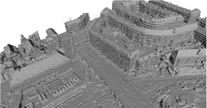
throughout the point cloud, is well handled by our approach. Fig-ure 7 depicts extracted mesh patches. As before, reconstructions are complete, but some faces are not consistent. Normals are re-liably computed and are, along with the point coordinates, suffi-cient for Poisson reconstruction (figure 8). Thereby in contrast to typical 2.5D datasets 3D structures as balconies and streets below bridges are successfully reconstructed.
Figure 7: Mesh patches generated from oblique airborne imagery. RQT error thresholdǫ= 2.4
4. CONCLUSION
In this article we presented an algorithm iteratively merging depth maps derived by DIM. Thereby the model state is represented as a set of oriented points and faces. The current model state is up-dated by either supplementing new surface patches by RQT tri-angulations of the depth maps or refining existing patches. If the pixel footprints of model entities and candidates from the depth maps largely vary, only the samples corresponding to the higher resolution are considered. Sampling distance of depth maps is dynamically controlled using a RQT. Moreover, visibility con-straints are implemented aiming at removing outliers. We tested the approach on an aerial oblique and a close range dataset. For both, the number of original points were reduced by up to90%
percent. Normals were computed reliably and outliers were re-moved such that subsequent Poisson reconstructions gave satisfy-ing results. For our test dataset increased samplsatisfy-ing rates resulted in a vertex reduction of factor 2 while giving comparable results. This is because spatially proximate samples not contributing to the geometry are excluded from further processing by the RQT triangulation. However, the property of matching triangulations is not maintained.
So far normals only serve as input for the extraction of water-tight meshes. In future work we plan to incorporate the surface normals into the fusion process to further improve precision, in-crease consistency of faces and eliminate depth estimations de-tected on slanted surfaces. Other issues we want to address is parallelization of codes and the capability of processing image tiles. This would allow for processing large frame imagery in a more efficient way enabling airborne applications at even larger scales.
ing complex models from range images. In: Proceedings of the 23rd annual conference on Computer graphics and interactive techniques, ACM, pp. 303–312.
Fuhrmann, S. and Goesele, M., 2011. Fusion of depth maps with multiple scales. In: Proceedings of the 2011 SIGGRAPH Asia Conference, SA ’11, ACM, New York, NY, USA, pp. 148:1– 148:8.
Furukawa, Y. and Ponce, J., 2010. Accurate, dense, and robust multiview stereopsis. IEEE Transactions on Pattern Analysis and Machine Intelligence 32(8), pp. 1362–1376.
Haala, N. and Rothermel, M., 2012. Dense multi-stereo matching for high quality digital elevation models. PFG Photogrammetrie, Fernerkundung, Geoinformation 2012(4), pp. 331–343.
Hermann, S. and Klette, R., 2012. Evaluation of a new coarse-to-fine strategy for fast semi-global stereo matching. In: Proceed-ings of the 5th Pacific Rim conference on Advances in Image and Video Technology - Volume Part I, PSIVT’11, Springer-Verlag, Berlin, Heidelberg, pp. 395–406.
Hiep, V. H., Keriven, R., Labatut, P. and Pons, J.-P., 2009. To-wards high-resolution large-scale multi-view stereo. In: Com-puter Vision and Pattern Recognition, 2009. CVPR 2009. IEEE Conference on, IEEE, pp. 1430–1437.
Hirschm¨uller, H., 2008. Stereo processing by semiglobal match-ing and mutual information. IEEE Transactions on Pattern Anal-ysis and Machine Intelligence 30, pp. 328–341.
Jancosek, M. and Pajdla, T., 2008. Cmpmvs - multi-view re-construction software. In: Proceedings of the International Sym-posium on 3D Data Processing, Visualization and Transmission (3DPVT).
Kazhdan, M. and Hoppe, H., 2013. Screened poisson surface reconstruction. ACM Trans. Graph. 32(3), pp. 29:1–29:13.
Lorensen, W. E. and Cline, H. E., 1987. Marching cubes: A high resolution 3d surface construction algorithm. In: Proceedings of the 14th annual conference on Computer graphics and interac-tive techniques, SIGGRAPH ’87, ACM, New York, NY, USA, pp. 163–169.
Lowe, D. G., 1999. Object recognition from local scale-invariant features. In: Computer vision, 1999. The proceedings of the sev-enth IEEE international conference on, Vol. 2, Ieee, pp. 1150– 1157.
Merrell, P., Akbarzadeh, A., Wang, L., Frahm, J.-M. and Nistr, R. Y. D., 2007. Real-time visibility-based fusion of depth maps. In: In Int. Conf. on Computer Vision and Pattern Recognition.
Pajarola, R., 1998. Large scale terrain visualization using the restricted quadtree triangulation. In: Visualization ’98. Proceed-ings, pp. 19–26.
Figure 8: Poisson reconstruction based on our point sets. RQT error thresholdǫ= 2.4
Pajarola, R., Antonijuan, M. and Lario, R., 2002. Quadtin: Quadtree based triangulated irregular networks. In: Proceedings of the conference on Visualization’02, IEEE Computer Society, pp. 395–402.
Rothermel, M., Bulatov, D., Haala, N. and Wenzel, K., 2014. Fast and robust generation of semantic urban terrain models from uav video streams. In: International Conference on Pattern Recogni-tion, Stockholm, Sweden.
Rothermel, M., Wenzel, K., Fritsch, D. and Haala, N., 2012. Sure: Photogrammetric surface reconstruction from imagery. In: Proceedings LC3D Workshop, Berlin.
Seitz, S. M., Curless, B., Diebel, J., Scharstein, D. and Szeliski, R., 2006. A comparison and evaluation of multi-view stereo re-construction algorithms.
Sivan, R. and Samet, H., 1992. Algorithms for constructing quadtree surface maps. In: Proc. 5th Int. Symposium on Spatial Data Handling, pp. 361–370.
Turk, G. and Levoy, M., 1994. Zippered polygon meshes from range images. In: Proceedings of the 21st annual conference on Computer graphics and interactive techniques, SIGGRAPH ’94, ACM, New York, NY, USA, pp. 311–318.
Zach, C., 2008. Fast and high quality fusion of depth maps. In: Proceedings of the International Symposium on 3D Data Process-ing, Visualization and Transmission (3DPVT), Vol. 1.