www.geosci-model-dev.net/10/385/2017/ doi:10.5194/gmd-10-385-2017
© Author(s) 2017. CC Attribution 3.0 License.
Implementation of street trees within the solar radiative exchange
parameterization of TEB in SURFEX v8.0
Emilie C. Redon1, Aude Lemonsu1, Valéry Masson1, Benjamin Morille2, and Marjorie Musy2
1CNRM UMR 3589, Météo-France/CNRS, Toulouse, France, 42 Avenue Gaspard Coriolis,
31057 Toulouse CEDEX 1, France
2Ecole nationale supérieure d’Architecture de Nantes, UMR 1563, Quai François Mitterrand, 44262 Nantes CEDEX 2, France
Correspondence to:Aude Lemonsu ([email protected])
Received: 20 June 2016 – Published in Geosci. Model Dev. Discuss.: 1 August 2016 Revised: 4 January 2017 – Accepted: 9 January 2017 – Published: 25 January 2017
Abstract.The Town Energy Balance (TEB) model has been refined and improved in order to explicitly represent street trees and their impacts on radiative transfer: a new vegetated stratum on the vertical plane, which can shade the road, the walls, and the low vegetation has been added. This modi-fication led to more complex radiative calculations, but has been done with a concern to preserve a certain level of sim-plicity and to limit the number of new input parameters for TEB to the cover fraction of trees, the mean height of trunks and trees, their specific leaf area index, and albedo. Indeed, the model is designed to be run over whole cities, for which it can simulate the local climatic variability related to ur-ban landscape heterogeneity at the neighborhood scale. This means that computing times must be acceptable, and that input urban data must be available or easy to define. This simplified characterization of high vegetation necessarily in-duces some uncertainties in terms of the solar radiative ex-changes, as quantified by comparison of TEB with a high-spatial-resolution solar enlightenment model (SOLENE). On the basis of an idealized geometry of an urban canyon with various vegetation layouts, TEB is evaluated regarding the total shortwave radiation flux absorbed by the elements that compose the canyon. TEB simulations in summer gathered best scores for all configurations and surfaces considered, which is precisely the most relevant season to assess the cool-ing effect of deciduous trees under temperate climate. Mean absolute differences and biases of 6.03 and+3.50 W m−2for
road, respectively, and of 3.38 and+2.80 W m−2 for walls
have been recorded in vegetationless canyons. In view of the important incident radiation flux, exceeding 1000 W m−2at solar noon, the mean absolute percentage differences of 3 %
for both surfaces remain moderate. Concerning the vegetated canyons, we noted a high variability of statistical scores de-pending on the vegetation layout. The greater uncertainties are found for the solar radiation fluxes received and absorbed by the high vegetation. The mean absolute differences aver-aged over the vegetation configurations during summertime are 21.12±13.39 W m−2or 20.92±10.87 % of mean abso-lute percentage differences for the total shortwave absorp-tion, but these scores are associated with acceptable biases: −15.96±15.93 W m−2.
1 Introduction
Joshi and Joshi, 2015) and reduce the radiation penetration in buildings in summer (Akbari et al., 1997, 2001; Simpson, 2002; Abdel-Aziz et al., 2015; Ko et al., 2015). For some years now, green roofs are implemented more intensively in cities. The cooling effects they induce on air temperature at pedestrian level are lesser than in those of trees or ground-based vegetation but they modify the energy budget at roof level (Taleghani et al., 2016). Nonetheless, they help to re-duce the temperature fluctuations of structural roofs and to better insulate buildings (Hien et al., 2007; Kokogiannakis et al., 2011). Many studies highlighted their efficiency for significant energy savings for heating and air conditioning (Jim, 2014). The implementation of pervious soils, whether at the ground or on buildings, also enables a more effective and sustainable management of rainwater by the storage of water in the soil and the decrease of surface water runoff (Armson et al., 2013; Yao et al., 2015; Zhang et al., 2015). Besides microclimatic and hydrological impacts, the urban vegetation is identified as a biodiversity reservoir for fauna and flora in cities (Alvey, 2006). It also plays its part in ar-chitectural atmospheres, and more widely in the perception of environmental quality by the population. The green spaces in an urban environment are generally perceived very pos-itively by inhabitants because they are places of wellness, detente, and user friendliness (Bertram and Rehdanz, 2015; Bowen and Parry, 2015).
In order to investigate some of the physical processes re-lated to the presence of vegetation in an urban environment, e.g., for microclimate, hydrology, or building energy con-sumption issues, the modeling is definitely a necessary tool. It is also pretty relevant and powerful to assess greening strategies by quantifying the potential impacts, and it con-sequently enables to answer to some important expectations of public stakeholders and urban planners.
The Town Energy Balance (TEB) urban canopy model (Masson, 2000) is applied today for many studies of climate change impacts at city scale. Among the numerous strategies of adaptation to climate change, and attenuation of the ur-ban heat island, the benefits of urur-ban environment greening has been investigated through more or less realistic scenarios. Kounkou-Arnaud et al. (2014) and de Munck (2013) have proposed and tested some strategies of ground-based vegeta-tion implementavegeta-tion for the city of Paris (France). They have evaluated the cooling potential of this vegetation through the evapotranspiration process during summer. They investigated and quantified the impacts in terms of decrease of air temper-ature inside the streets, as well as improvement of thermal comfort conditions outside and inside buildings. The works of de Munck (2013) have also addressed the issues of build-ing energy consumption and of water resource at multiyear and seasonal scales.
For such modeling exercises, TEB had been previously improved in order to explicitly represent urban vegetation within the canyon and to parameterize at small scale the ra-diative and energetic interactions between the built-up covers
and the vegetation (Lemonsu et al., 2012). All types of vege-tation are however managed as a ground-based layer: leaves can be in shade of buildings but do not create shadow effects themselves on roads or buildings. With the current develop-ments, we attempt to remedy this lack by modifying the so-lar radiation budget of tree-filled canyons. The tree layer can now shade ground-based surfaces and walls. In this way, in-terception, transmission, or absorption of solar radiation by this additional non-opaque surface are computed. These im-plementations are evaluated by a comparison with simula-tions provided by a microscale radiation model: SOLENE, developed at the CERMA laboratory in Nantes, France.
2 Urban high-vegetation modeling
Until recently, very few urban climate models were able to take into account natural soils and vegetation. This fact con-stitutes a significant limitation in modeling the radiative and energetic exchanges in urban environments, according to the results of the intercomparison exercise of urban models per-formed by Grimmond et al. (2011). Most of models that al-ready included vegetation were based on the tiling approach which consists of dealing separately with impervious covers and natural covers with distinct parameterizations and with-out microscale interactions between vegetation and built-up elements. However, an important effort has been conducted these last years in order to improve the representation of physical processes related to the presence of vegetation in ur-ban climate models. Suburur-ban and residential areas are char-acterized by an abundant vegetation (all types combined), while trees are predominant in cities. This feature of most cities has motivated the concern of improving urban micro-climate modeling in such areas. Krayenhoff et al. (2014) present an exhaustive literature review of existing models and their characteristics.
sur-rounding elements are computed at the center of the surface. The attenuation of radiation by leaves is included in equa-tions when shortwave or longwave radiation crosses the fo-liage. It depends on transmissivity properties of foliage – in-spired by works of Yamada (1982) for forest canopies – that follow an exponential law based on the LAD profile and a modulation factor depending on vegetation type. More re-cently, Young et al. (2015) have developed and tested a sim-ilar parameterization for street trees (TUrban) in the single-column reading urban model (SCRUM, Harman and Belcher, 2006; Porson et al., 2009). The tree canopy is explicitly de-scribed as a rectangle located in the middle of the canyon and assumed to be lower than building height. The view factors for both fully visible and partially occluded facets due to the presence of the foliage are calculated in an analytic manner, based on Hottel’s crossed string construction (Hottel, 1954). The model implemented by Ryu et al. (2015) considers two explicit and symmetric trees with circular crowns. The Monte Carlo algorithm developed by Wang (2014) is executed once at the beginning of the simulation and subsequently trans-formed into simple relations to determine view factors for which trees are involved. Shortwave and longwave radiation exchanges but also sensible and latent heat exchanges and root water uptake processes are represented.
The building effect parameterization with trees (BEP-Tree) model is the first multilayer model of urban energy exchange and flow at the neighborhood scale that includes trees and both their radiative (Krayenhoff et al., 2014) and dynamic (Krayenhoff et al., 2015) effects on buildings. View factors are also computed using a Monte Carlo ray-tracing approach. The clustered distribution of tree crowns is taken into account through a unique clumping factor for all the veg-etation of the canyon. Tree foliage can be present both within and above the canyon and above the roofs.
For large eddy simulations (LESs) in an urban environ-ment, a vegetated urban canopy model (VUC) has been in-tegrated by Tavares et al. (2015) in the advanced regional prediction system (ARPS) model. This ARPS-VUC version distinguishes the tree canopy from natural soils and ground-based vegetation. The radiative calculations are however rather simplified in relation to dynamics. The net radiation flux decreases exponentially from the top of urban canopy to the ground depending on the canopy density which in-cludes both tree vegetation and buildings. For a microscale urban climate model such as ENVI-met (Bruse and Fleer, 1998), the fine meshing enables to resolve explicitly each ele-ment which composes the urban environele-ment by distinguish-ing builddistinguish-ings, impervious and natural ground-based surfaces, vegetation, and air. Absorption coefficients of radiation by vegetation (based on an exponential formulation) are cal-culated at each vertical level, according to the vertical pro-file of LAD. The SOLENE-microclimat model (based on the SOLENE radiative model) is able to represent the evapora-tive, shading, and insulating characteristics of green walls and roofs, modeled as surfaces (Malys, 2012). The trees are
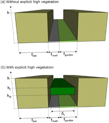
Figure 1.Comparison of the spatial arrangement of elements com-posing the urban canyon and of associated geometric parameters applied in the TEB model in the reference case (top) and in the case with explicit high vegetation (bottom).
modeled as porous volumes in the airflow model and as semi-transparent crowns in the radiative model; the energy balance (evaporative, convective, and radiative fluxes) being coupled to these models (Robitu et al., 2006). This balance leads to the assessment of leaves and air temperatures.
3 General concept of TEB and urban trees representation
3.1 Description of urban areas in TEB
At each mesoscale model grid point, TEB describes the av-erage characteristics of the local environment by a single ur-ban canyon composed of a ground-based surface bordered by two flat-roof buildings of same height. The urban environ-ment is thus described in TEB based on four distinct eleenviron-ments that compose the urban canyons: “roof”, “wall”, and for the ground-based surfaces, a combination of impervious and nat-ural covers referred to as “road” and “garden”, respectively (Fig. 1).
de-Table 1.Main descriptive parameters of the urban canyon, including vegetation, in the TEB model. The parameters followed by an asterisk are the input data prescribed by user, the other ones are computed in the model using the input parameters.
Parameters Symbol Unit
Cover fraction of buildings∗ f
bld –
Cover fraction of ground-based natural covers (garden)∗ f
garden –
Proportion of bare soil in gardens∗ δ
nv –
Proportion of low vegetation in gardens δlv=1−δnv – Cover fraction of tree canopy∗ δ
t –
Mean building height∗ h m
Wall plan area ratio∗ r
w –
Canyon aspect ratio h/w=0.5rw/(1−fbld) – Height of tree canopy∗ h
t m
Height of trunk∗ h
tk m
Mid-height of tree’s crown hcw=(ht+htk)/2 m Sky view factor of wall, road, garden, tree 9ws, 9rs, 9gs, 9ts – View factor of road, tree from wall 9wr, 9wt – View factor of wall, tree from road 9rw, 9rt – View factor of wall, road from tree 9tw, 9tr – Leaf area index of low vegetation in gardens∗ LAI
g m2m−2
Leaf area index of tree canopy∗ LAI
t m2 m−2
Leaf area density of tree canopy LADt m2m−3 Albedo of wall, road, garden, tree∗ α
w, αr, αg, αt – Emissivity of wall, road, garden, tree∗ ǫ
w, ǫr, ǫg, ǫt –
pending on construction materials: albedo and emissivity are prescribed for outdoor surface coating of roofs, walls, and roads; thermal conductivity and heat capacity are defined for the ensemble of materials composing buildings and road-ways. For each urban facet (roof, walls, and road) separately, the model computes a radiation budget and a surface energy balance. It also resolves an equation of temperature evolution with a single surface temperature associated with each facet. For natural soils and vegetation, the radiative and energetic exchanges with atmosphere, as well as the hydrological and thermal processes in the ground, are parameterized with the interaction soil–biosphere–atmosphere model (ISBA) model (Noilhan and Planton, 1989). The vegetation stratum is de-scribed in the ISBA model as an aggregation of bare soil, low stratum (grass), and high stratum (trees) of vegetation. This vegetation stratum is characterized by composite descriptive and physiologic properties that are calculated starting from properties of these different types of natural covers. They include albedo and emissivity (depending of proportion of bare soil and vegetation), leaf area index, stomatal resistance, and roughness length. Note that some of those properties can evolve seasonally, but also in the event of snowfall which modifies radiative properties. The vegetation stratum is con-nected with a soil column, with which hydrological and ther-mal properties are associated depending on soil texture and water content evolution (Boone et al., 1999).
This reference version of TEB is based on two important simplifications. First, there is no explicit spatial arrangement of the garden within the canyon. They are only represented
as land cover fractions. In addition, the vegetation stratum, even if it can be composed of trees (through the definition of specific physiological properties), is always placed on the ground without vertical extent. This means that shadow ef-fects on the ground and buildings related to the presence of high vegetation are not taken into account, and that there is no vertical distribution of turbulent energy exchanges between vegetation and atmosphere.
3.2 General principles of solar radiation exchange parameterization in TEB
The present study describes the improvements of the radia-tion budget calcularadia-tions in TEB by the implementaradia-tion of ex-plicit high vegetation. Consequently, this section is focused on the description of the radiative exchanges in the initial ver-sion of TEB. The parameterization of turbulent heat fluxes and of heat conduction processes, as well as the calculations of microclimate parameters within the canyon, are not pre-sented here but they are detailed by Masson (2000), Lemonsu et al. (2004), Hamdi and Masson (2008), Masson and Seity (2009), and Lemonsu et al. (2012).
hypothesis of isotropic orientation of streets is applied, and in this case, walls are managed together (implying that they will have identical temperature evolutions).
The shortwave and longwave radiation budgets are re-solved in TEB for each element composing the urban canyon (roofs, walls, road, ground-based vegetation, and now tree canopy) with the aim of determining the energy absorbed by each element that is used afterward to compute the surface energy budget.
More specifically for the shortwave radiation budget, three contributions are considered for a given element:
1. The direct solar radiation received before any reflections depends on zenith angle since the incident direct radia-tion is unidirecradia-tional, street orientaradia-tion, and canyon as-pect ratio.
2. The diffuse solar radiation received before any reflec-tions depends on the sky view factor of the considered element since the diffuse radiation is assumed to be isotropic.
3. Finally, the total shortwave radiation received after mul-tiple reflections within the canyon is computed. After a first reflection on one of the elements of the canyon, initial contributions of direct and diffuse radiation are isotropic and are treated the same way. The part of radi-ation received by a given element then depends on the view factors of all the other elements and on their albedo to determine the reflected radiation part.
Although this paper focuses on resolution and evaluation of the shortwave radiation budget, it is worth to note that the validation of our shortwave radiation scheme contributes to verifying our future longwave radiation scheme. Indeed, the same view factors used for the multiple reflections will be applied to the longwave radiation interactions within the canyon. The longwave exchanges are computed following a linear approximation of the Stefan–Boltzmann law. For nu-merical stability purposes, an implicit formulation is applied for longwave radiation budgets; it includes the surface tem-peratures at the previous numerical time step and at the cur-rent time step.
3.3 Inclusion of a high-vegetation stratum for solar radiation calculation
To take into account the tree canopy in TEB, it is required to add a new vegetated stratum on the vertical plane, which can shade the road, the walls, and the low vegetation. This modification led to more complex radiative calculations, but is done with a concern to preserve a certain level of sim-plicity and to limit the number of new input parameters for TEB. This is motivated by the type of applications which are conducted with the TEB model, and more generally with the SURFEX land surface modeling platform (Masson et al., 2013) which TEB is part of. The system is frequently applied
over domains of several hundred square kilometers with hor-izontal resolutions between a few hundred meters and a few kilometers and can be run for long time periods up to several years in the cases of climatic studies (e.g., Lemonsu et al., 2013; de Munck, 2013, in French). This means that comput-ing times must be acceptable, and that urban input data must be available or easy to define.
The arrangement of tree canopy is described here using three parameters only (Fig. 1 and Table 1): its cover frac-tion (δt), i.e., the proportion of canyon which is covered by
the foliage stratum on the horizontal plane, as well as the mean height of trees (ht), and the mean height of trunks (htk).
In the current version of TEB (official SURFEX v8.0), ur-ban trees are assumed to be less tall than surrounding build-ings and systematically confined inside the canyon so that they cannot provide shade for roofs. This hypothesis is in accordance with common urban planning specifications for street tree management in Europe (in French, Municipality of Toulouse, 2008; City of Westminster, 2009; Barcelona City Council, 2011). These documents ensure a satisfactory jux-taposition of trees with urban structures for dwellers. Mini-mum distances between trunks or crowns and walls or bal-conies are strictly imposed to avoid problems such as ex-cessive obstruction of crowns facing windows, disruption of underground services by roots or subsidence of buildings. These widespread practices are also applied in private gar-dens or suburban areas and tend to avoid shadow on roofs even if street trees can be taller than buildings. Design with trees shading roofs is statistically sparse and their impact on surface balance is limited. At this stage, the application of TEB to low-density neighborhoods is restricted if trees can significantly shade buildings. They are probably located in high latitudes where incoming fluxes are lower than in mid-latitudes or low mid-latitudes, and this potential bias would only occur in the early morning or late evening, when the zenith angle is large but the solar radiation flux far less energetic than around noon.
For now, the shape of the foliage and the vertical distribu-tion of leaves are not defined. The crowns of trees are con-sidered as rectangular parallelepipeds (namely computed as a rectangular cross-section in a two-dimensional plane perpen-dicular to the street axis) with homogeneous foliage which is described by a leaf area index (LAIt) and an albedo (αt).
re-flected or absorbed, depending on albedo. These processes and the associated calculations are detailed hereafter.
4 Solar radiation absorption of vegetated street canyon surfaces
In this part, equations related to the implementation of a tree layer into the TEB model are presented. In order to calcu-late these terms in TEB, Sect. 4.1 and 4.2 describe how di-rect and diffuse solar radiation fluxes reach canyon surfaces. Then, absorption is obtained by separately resolving the first absorption of total shortwave radiation on each surface and the sum of absorbed shortwave radiation after infinite reflec-tions within the canyon.
4.1 Direct solar radiation received by each element The foliage of trees plays a role of obstruction and attenua-tion of incident direct solar radiaattenua-tion (S⇓) for the other el-ements of the urban canyon. Consequently, to determine the direct solar radiation received by each element of the canyon, we need to first solve the equations related to high vegetation. The direct solar radiation potentially reaching the top of trees by geometrically taking into account the shading of buildings depends on building height (h), canyon aspect ratio (h/w), street orientation (θcan), zenith and azimuth angles (λ, θsun), as well as tree height (ht):
St⇓= (1)
S⇓max
0;1− h w
h
−ht h
tan(λ)sin|θsun−θcan|
.
As previously explained, this radiation flux is partially transmitted through the foliage (S≫t ), whereas the remaining solar radiation is reflected (St⇑) or absorbed (S∗
t):
St⇓=St≫+St⇑+St∗. (2)
The proportion of direct solar radiation transmitted through the foliage is estimated by the Beer–Lambert law (Campbell and Norman, 1989) where the leaf area index (LAIt, expressed in m2of leaves per m2of ground) of tree
canopy and an extinction coefficient (k) are involved. The extinction coefficient is fixed to 0.5, a default value corre-sponding to a homogeneous distribution of leaves in terms of density and orientation (in other words, a spherical leaf angle distribution):
St≫=St⇓exp(−kLAIt). (3)
The reflected radiation part simply depends on the part of incident solar radiation untransmitted through the foliage and on the albedo of trees (αt):
St⇑=αtSt⇓
1−exp(−kLAIt). (4)
Finally, the incident direct solar radiation part absorbed by trees is neither transmitted nor reflected and calculated as the residual term from Eq. (2):
St∗=(1−αt) St⇓
1−exp(−kLAIt). (5)
The direct solar radiation received by the ground (indis-criminately road or garden fraction) is deduced by correct-ing the incident solar radiation above the canyon from the interception of radiation by high-vegetation canopy (i.e., re-flected and absorbed radiation weighted by high-vegetation cover fraction, referred to asδt), and then from the shading
effects of buildings (according to Lemonsu et al., 2012). The same equations are obtained for road (Sr⇓) and garden (Sg⇓): Sr⇓=
S⇓−δt
St⇑+S∗t
(6) max
0;1− h
wtan(λ)sin|θsun−θcan|
.
In this way, tree foliage is assumed to be uniformly dis-tributed across the canyon at the height of the trees (ht),
con-sistently with Eq. (1).
The direct solar radiation which is not received by high vegetation, road or garden is assigned to the sunlit wall, whereas the opposite wall is in the shadow. By convention in TEB in the case of an oriented canyon, we define wall A as the most sunlit wall and wall B as the shaded one.
Sw⇓A=
S⇓−S⇓r −δt
St⇑+St∗w
h (7)
Sw⇓B=0 (8)
Note that shading effects of high vegetation on roofs are not represented, since urban trees are less tall than buildings by definition in the current version of TEB (SURFEX v8.0). 4.2 Diffuse solar radiation received by each element The incoming diffuse solar radiation (S↓) is assumed to emit isotropically. Each urban surface of the canyon (wall, road, and garden) receives a part of diffuse solar radiation accord-ing to the sky view factor of the surface9∗(see Appendix A)
and the mean radiative transmissivity between the sky and the given surface τ∗s (see Appendix B). Note that the sky
view factor of “wall” is defined at mid-height of buildings; for ground-based surfaces “road” and “garden”, a single sky view factor9rs=9gs is defined at the center of the street
(Masson, 2000; Lee and Park, 2008). The following equa-tions are obtained for “road” (same expression for “garden”) and for “wall”:
Sr↓=S↓9rsτrs (9)
Sw↓=S↓9wsτws. (10)
reaches the tree canopy:
St↓=
S↓−δrSr↓+δgSg↓+2whSw↓
δt
. (11)
This method presents two major advantages: (1) the dif-fuse solar radiation budget is always closed, and (2) the com-puted diffuse solar radiation flux for the high vegetation is al-ready corrected from the transmitted part, reaching the other surfaces.
The fluxes of each surface are expressed here according to the total ground-based surface of the canyon, withδrandδg
the cover fractions of road and garden in the canyon (δr+δg=
1), respectively.
4.3 First absorption of total shortwave radiation by each element
The first absorption of total shortwave radiationS∗(0), before
any reflections, is only a function of the total shortwave ra-diation received by the considered element and of its albedo (α∗). The same expression is obtained for walls and
ground-based surfaces (∗which stands for “r”, “g”, “wA”, or “wB”): S∗∗(0)=(1−α∗)
S∗⇓ + S∗↓
. (12)
For the tree canopy, the part of absorbed direct solar radi-ation is corrected by the transmitted flux:
St∗(0)=(1−αt) h
St⇓ − S≫t
+ St↓ i
. (13)
St⇓ includes the transmitted fluxSt≫(see Eq. 2) contrary to St↓which is calculated as a residual flux (Eq. 11), corrected from the transmitted flux.
4.4 Sum of total shortwave radiation absorbed by each element
Our goal is to compute the total shortwave radiation absorp-tion for each elementS∗(∞)by taking into account an infi-nite number of reflections between all elements composing the urban canyon. At each reflection, the isotropic radiation intercepted by a given element, (1), after reflections on one of the other elements, (2), is conditioned by the view fac-tor of (2) from (1), referred to as912(see Appendix A), the
mean radiative transmissivityτ12 (see Appendix B), and the
absorption is then determined according to reflective proper-ties of (1). Using a single view factor in TEB radiation cal-culations is obviously a limitation for accurately representing the various contributions of canyon’s surfaces to high vegeta-tion. Additionally, we have a poor knowledge of the forward scattering or trapping effects occurring within the crowns. Because of the description of the canopy as a surface, TEB neglects these processes, but the attenuation and transmission applied at the top of the canopy (see Eqs. 3, 4, and 5 arising
from Eq. 1) could be adjusted in order to implicitly include these phenomena. To ensure a closing system, we define the total absorbed shortwave radiation by high vegetation as the remaining shortwave radiation, after accounting for absorp-tion and reflecabsorp-tion from the total incident solar radiaabsorp-tion by all other elements of the canyon. This requires calculating the part of shortwave radiation which leaves the canyon to-wards the sky. The termsR∞,G∞,A∞,B∞, andT∞make
reference to the sum of total shortwave radiation reflected by each surface, respectively, after an infinite number of re-flections (see detailed resolution in Appendix C). Here is the expression of the total absorbed solar flux per surface:
Ss∗(∞)=9srτsr(δrR∞+δgG∞) (14)
+9swτswA∞+B∞
2 +9stδtT∞
Sr∗(∞)=Sr∗(0)+(1−αr) (15)
9rwτrwA∞+B∞
2 +crt9rtδtT∞
Sg∗(∞)=Sg∗(0)+ 1−αg (16)
9rwτrw
A∞+B∞
2 +crt9rtδtT∞
Sw∗A(∞)=Sw∗A(0)+(1−αw)[9wrτwr(δrR∞ (17)
+δgG∞+9wwτwwB∞+cwt9wtδtT∞
Sw∗B(∞)=Sw∗B(0)+(1−αw)[9wrτwr(δrR∞ (18)
+δgG∞
+9wwτwwA∞+cwt9wtδtT∞
St∗(∞)= 1 δt
h
S⇓+S↓− Ss∗(∞)+δrSr∗(∞) (19)
+δgSg∗(∞)+
2h w
Sw∗A(∞)+Sw∗B(∞) 2
.
5 Comparative exercise with the SOLENE model An objective and exhaustive assessment of the new solar ra-diation calculations in TEB related to the inclusion of tree layer effects is not an easy exercise, essentially due to the lack of experimental data. Indeed, very few measurements for documenting radiative effects of trees in an urban envi-ronment are available (Park et al., 2012). The objective here is to quantify the performances of TEB in simulating the dif-ferent contributions of the solar radiation budget for the en-semble of urban facets and vegetation. For this purpose, we compare TEB with the SOLENE software, which is a high-spatial-resolution solar and lighting architectural model and which is used in this work as a reference. Various configura-tions of urban canyons with street trees (that differ in terms of vegetation density and spatial distribution) are studied so that the capacities and limits of the TEB geometric approach can be highlighted and evaluated.
5.1 General presentation of the SOLENE model The SOLENE model (Miguet and Groleau, 2002; Robitu et al., 2006; Groleau and Mestayer, 2013) incorporates a ra-diative transfer scheme based on the radiosity method which is applied to meshed scenes with triangular facets, particu-larly adapted to complex geometries (Bouyer et al., 2011; Malys et al., 2014). This model provides a good tool to study urban radiation distinguishing solar radiations (separate di-rect and diffuse components, 0.3–2.5 µm) and infrared ther-mal radiations (2.5–18 µm).
In this research work, we consider the shortwave radiation scheme only. The incoming direct solar radiation is calcu-lated by considering the sun as a point source, recalcu-lated to so-lar height (following the formula in De Brichambaut, 1963) and angle of incidence of rays at the surface (Miguet, 2000). The incoming diffuse part of solar radiation is represented as a non-uniform distribution coming from a sky vault de-fined by a hemisphere of infinite radius, which is meshed us-ing a geodesic triangulation. The luminance values that are mapped on the hemisphere are derived from the Perez model (Perez et al., 1993). This model, based on five sky clearness and brightness parameters, provides statistical distribution depending on weather type represented. Multiple reflections are computed assuming that the surfaces are Lambertian and opaque for urban surfaces while the vegetation surfaces are semitransparent (Robitu et al., 2006). Solar simulations are performed in successive stages. The first one, based on geo-metric procedures, determines the visibility considering so-lar masks between two mesh elements or a mesh element and a sky patch of the sky vault model (including sun). View factors (including sky view factors) are produced for each mesh. The second stage calculates the solar radiation fluxes received by each mesh element for the time step. Then, the multiple reflections are computed by the radiosity method.
This last stage provides the net solar flux received by each mesh as well as absorbed and reflected parts.
The trees have been implemented from the evolution of SOLENE into the microclimate model named SOLENE-microclimat (Robitu et al., 2006). In this new model, the trees are geometrically modeled by their external envelope and are considered as semitransparent. Therefore, a percent-age of the solar radiation is transmitted by the tree canopy according to a transmission coefficient (fixed to 0.5) and di-rectionally reaches the other elements of the urban scene. The intercepted part of the solar radiation flux is either reflected or absorbed, depending on the tree albedo. Radiative proper-ties of the high vegetation are homogeneously applied to all the meshes which belong to the surface of vegetation blocks. A separate balance is computed for each mesh using specific view factors. Currently, no explicit foliage elements or intra-canopy processes (as forward scattering) are represented in the radiative model of trees in SOLENE-microclimat.
5.2 Configuration of numerical experiments 5.2.1 Canyon modeling in SOLENE
The urban canyon geometry chosen for building SOLENE’s mockups is as simple as possible to reflect the hypotheses of TEB: an infinite street (150 m in length in the mockups) bor-dered by two identical buildings with flat roofs. As shown in Fig. 2, it is defined here in three different urban canyon forms corresponding to aspect ratios (referred to ash/w) of 0.5, 1, and 2. For the first two aspect ratios, the building height is 8 m and the width of the street is 16 m forh/w=0.5 and 8 m forh/w=1. Forh/w=2, building height is 16 m and width of the street is 8 m.
Figure 2.Description of simple geometries of an urban canyon selected for the comparison between TEB and SOLENE simulations. For each of them, the potential location of tree canopy is illustrated by dotted rectangles.
Figure 3.Description of the SOLENE mockup and presentation of the ensemble of vegetation layouts selected for the comparison between TEB and SOLENE simulations. The cases are presented here for the example of the urban canyon withh/w=2 rescaled vegetation (see Sect. 5.2.1 and Fig. 2 for further explanations).
to 0.25 for road, 0.30 for walls, and 0.25 for trees. All con-figurations are described in Figs. 1, 2, 3, and Table 2.
To treat the ensemble of configurations, 55 digital mock-ups (52 canyons with vegetation and 3 canyons without vegetation) have been built with the computer-aided design (CAD) software Salome V7_4_0. All mockups have been meshed by the GMSH software which is a finite element mesh generator. We have applied a non-uniform meshing here, with a characteristic length of only 1 m in order to refine the spatial discretization of vegetation blocks, whose small-est ones for some of the vegetation layouts do not exceed 2.4 m width and 2.5 m height.
Each canyon is projected following the four street orienta-tions 0, 45, 90, and 135◦(degrees from geographical north,
in the counter trigonometric direction). A specific location (defined by latitude and longitude) must be prescribed for
astronomic calculations. The city of Nantes (France) is cho-sen in an arbitrary manner (46◦N, 1◦E). The solar radiation
exchanges are then calculated for a single daily cycle, and un-der sunlight conditions covering the four seasons by select-ing dates close to equinoxes and solstices of the year 2010, i.e., 20 March, 21 June, 23 September, and 23 December of 2010. Note also that the Perez model (see Sect. 5.1) has been parameterized in order to generate perfectly clear cloudless skies.
5.2.2 Canyon modeling in TEB
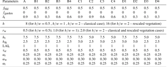
Table 2.List of input parameters for the ensemble of simulations performed with TEB.
Parameters A B1 B2 B3 B4 C1 C2 C3 C4 D1 D2 D3 D4
fbld 0.5 0.5 0.5 0.5 0.5 0.5 0.5 0.5 0.5 0.5 0.5 0.5 0.5
fgarden 0 0 0 0 0 0 0 0 0 0 0 0 0
δt 0.9 0.3 0.3 0.6 0.6 0.9 0.9 0.6 0.6 0.3 0.3 0.3 0.3
h 8 (forh/w=0.5 ,h/w=1 ,h/w=2 – classical case); 16 (forh/w=2 – rescaled vegetation)
rw 0.5 (forh/w=0.5); 1.0 (forh/w=1); 2.0 (forh/w=2 – classical and rescaled vegetation cases)
ht 7.5 7.5 7.5 7.5 7.5 7.5 5.0 7.5 5.0 7.5 7.5 5.0 5.0
htk 2.5 2.5 2.5 2.5 2.5 5.0 2.5 5.0 2.5 5.0 5.0 2.5 2.5
LAIt 1 1 1 1 1 1 1 1 1 1 1 1 1
τsr 0.5 0.5 0.5 0.5 0.5 0.5 0.5 0.5 0.5 0.5 0.5 0.5 0.5
αr 0.25 0.25 0.25 0.25 0.25 0.25 0.25 0.25 0.25 0.25 0.25 0.25 0.25
αw 0.30 0.30 0.30 0.30 0.30 0.30 0.30 0.30 0.30 0.30 0.30 0.30 0.30
αt 0.25 0.25 0.25 0.25 0.25 0.25 0.25 0.25 0.25 0.25 0.25 0.25 0.25
the urban canyon form, as well as the height of trees and trunks, are comparable to those of SOLENE simulations. But the different spatial arrangements of trees simulated by SO-LENE are simply prescribed as cover fractions in TEB. As a result, some configurations (e.g., B1 and B2 with different horizontal locations or B3 and B4 with different numbers of tree lines, shown in Fig. 3) cannot be distinguished by the TEB approach, and are associated with the same cumulative cover fraction of tree canopy in TEB. In this manner, inter-actions between tree lines are not taken into account in TEB, contrary to SOLENE, where rays are attenuated at each time they cross a mesh belonging to a vegetated envelope. All ge-ometric features of both sets of simulations with SOLENE and TEB are summarized in Table 2. In SOLENE, the inci-dent radiation is roughly attenuated by 50 % once it crosses a mesh which belongs to a vegetation envelope. In terms of process modeling, the formulation of transmissivity of radi-ation through the foliage in TEB is simplified here for the evaluation stage. In order to be consistent with the SOLENE approach, the exponential attenuation expressing a maximum interception (including the leaf area index) in Eqs. (3), (4), and (5) is replaced by 0.5. The same way, the formulation proposed in Appendix B (Eqs. B1, B2, B3, and B4) for mod-ulating the radiation attenuation depending on the likely path of rays and based on the leaf area density profile, is sub-stituted here by the expression 1−0.5(LAD/LAI), so that the maximum attenuation is 0.5 when all thickness of tree canopy is passed through. Note also that TEB is forced by the same conditions of incoming solar radiation than those calculated for the roofs in SOLENE. Using a unique forc-ing for each component (direct or diffuse) of the solar radi-ation from the SOLENE simulradi-ations, TEB forcings do not take into account the non-uniform distribution of incoming diffuse solar radiation. From this imprecision differences re-sult from 1 to 4 % between the fluxes of the two walls,
de-pending on their orientation, for studied aspect ratios during summertime (sensitive analysis not shown).
5.2.3 Comparison method
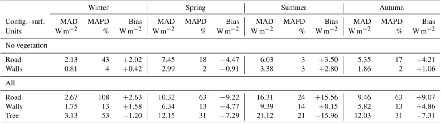
Table 3.Statistical scores for absorbed shortwave radiation flux by surfaces regarding the seasons.
Winter Spring Summer Autumn
Config.–surf. MAD MAPD Bias MAD MAPD Bias MAD MAPD Bias MAD MAPD Bias
Units W m−2 % W m−2 W m−2 % W m−2 W m−2 % W m−2 W m−2 % W m−2
No vegetation
Road 2.13 43 +2.02 7.45 18 +4.47 6.03 3 +3.50 5.35 17 +4.21
Walls 0.81 4 +0.42 2.99 2 +0.91 3.38 3 +2.80 1.86 2 +1.06
All
Road 2.67 108 +2.63 10.32 63 +9.22 16.31 24 +15.56 9.46 63 +9.07
Walls 1.75 13 +1.58 6.34 13 +4.77 9.39 14 +8.15 5.82 13 +4.86
Tree 3.13 53 −1.20 12.15 31 −7.29 21.12 21 −15.96 12.03 31 −7.31
the mean daily fluxes, and the mean bias (bias in W m−2), according to following equations:
MAD= (20)
Pns
i=1 Pno
j=1 Pnh
k=1 Pnt
l=1|FSOL(i, j, k, l)−FTEB(i, j, k, l)| ns·no·nh·nt
MAPD= (21)
100·
Pns
i=1Pnjo=1Pnk=1h
FSOL(i,j,k)−FTEB(i,j,k) FSOL(i,j,k)
ns·no·nh
Bias= (22)
Pns
i=1 Pno
j=1 Pnh
k=1 Pnt
l=1(FSOL(i, j, k, l)−FTEB(i, j, k, l)) ns·no·nh·nt .
The indexes i, j, k, l refer to as season, street orienta-tion, aspect ratio of the street, and hour of the day, respec-tively, with ns=4, no=4, nh=3, nt=24. We also run
simulations of theh/w=2 additional cases where canyons are greened with a rescaled vegetation (see Sect. 5.2.1 and Fig. 2).
6 Results
6.1 General analysis and seasonal effects
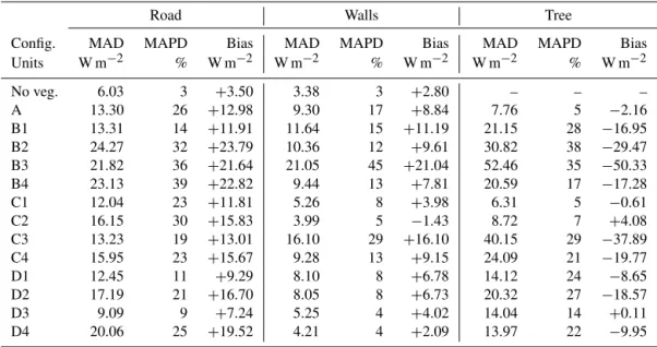
Table 3 presents the statistical scores computed for the short-wave radiation absorbed by the different elements of the canyon for both cases (with and without vegetation). Since multiple reflections are treated differently between TEB and SOLENE, these results are used to show the magnitude of variability of differences related to the presence of vegeta-tion in the canyon or the considered season. Results are pre-sented here by gathering the experiments performed with dif-ferent street orientations and difdif-ferent vegetation layouts, but by distinguishing the seasons. In the light of the mean biases, the TEB model tends to systematically overestimate the ab-sorption by road and walls compared to SOLENE (up to+16 and+8.5 W m−2for road and walls, respectively), and to
un-derestimate the absorption by trees (up to−16 W m−2), re-gardless of the configuration or the season. Considering that the temperate climate is characterized by four distinct sea-sons with contrasting sunshine, air temperature, and humid-ity conditions, seasonal analysis was undertaken. Analysis of the results for each season separately indicates that rela-tive differences (MAPD) are particularly high for wintertime simulations for road and trees, due to a very low incoming so-lar radiation in that period. Nonetheless, the associated MAD and biases are acceptable (less than 3.5 and±3 W m−2,
re-spectively). Summer is the season which provides the best results in terms of MAPD when the canyon is tree filled (less than 25 %) or not (3 %). This season is also the most relevant to be examined here because our first concern is to improve the simulation of the potential cooling effect of street trees in a urban environment, submitted to a strong urban heat is-land at this period. The evaluation is focused on effects of deciduous trees which are typical and widely present in cities under temperate climate. Such trees are leafless during win-ter, so that they have a negligible impact on thermal comfort and energy demand in this season. That is why we focus on the summertime example hereafter, to assess the TEB perfor-mances for simulating the solar radiative exchanges in ideal-ized canyons, vegetated or not.
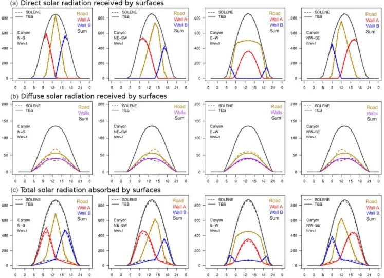
Figure 4.Comparison of TEB and SOLENE simulations of hourly direct (top) and diffuse (middle) solar radiation fluxes (W m−2) received by urban facets before multiple reflections, and total shortwave radiation fluxes (W m−2) absorbed by urban facets after inter-reflections (bottom) for urban canyons without vegetation. The results are presented here only for the aspect ratio equal to 1 and for the four street orientations during a summer day.
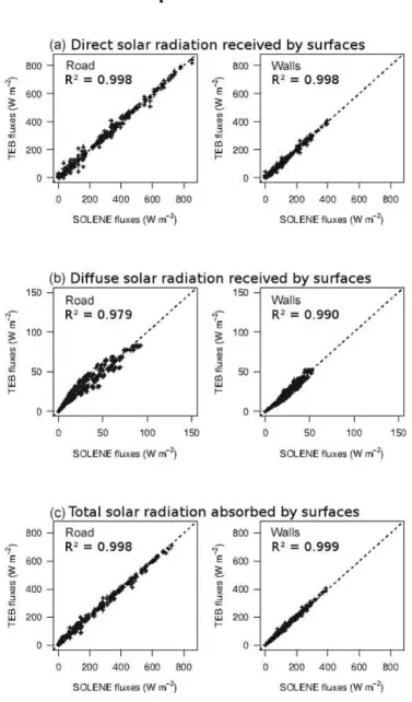
Both direct and diffuse solar radiation received by the road and the separate walls before any reflections, as well as the total shortwave radiation absorbed by these surfaces, are studied. An example of daily cycle is presented in Fig. 4 for the case whereh/w=1 and the four street orientations, for the summer season. The scatterplots integrate all the hourly fluxes simulated for the three aspects ratios, the four street orientations, and the four seasons (Fig. 5). As expected, they demonstrate a strong positive linear relationship between fluxes calculated by SOLENE and TEB (R2≥0.99 except for diffuse solar radiation absorbed by roads: R2=0.979) despite various meteorological conditions.
The comparison between SOLENE and TEB simulations for the direct solar radiation received by road and walls be-fore any reflections highlights very good results. TEB is able to reproduce the geometrical effects of the canyon on radiation penetration according to the time of the day, as well as the street orientation. For northeast–southwest and northwest–southeast-oriented streets, TEB correctly
simu-lates the dissymmetry of fluxes between the two walls, as well as the temporal shift in peak of radiation received by the road in comparison with the north–south-oriented street. For the east–west street case, the direct radiation received by the road is marked by a plateau effect between 08:00 and 19:00 LT. The two walls have different behaviors: the wall most exposed to the sun receives the maximum direct radiation at solar noon, whereas the most shaded wall re-ceives direct radiation only early in the morning and late in the afternoon. The scores confirm the good performances of TEB: MAD are 4.39 and 2.49 W m−2, and biases are−0.28
and+0.40 W m−2for road and walls, respectively (Table 4). They are associated with low MAPD of only 1 % for both road and walls.
Figure 5.Scatterplots comparing TEB and SOLENE simulations of hourly direct (top) and diffuse (middle) solar radiation fluxes (W m−2) received by urban facets before multiple reflections, and total shortwave radiation fluxes (W m−2) absorbed by urban facets after inter-reflections (bottom) for urban canyons without vegeta-tion. Each scatterplot gathers the hourly fluxes simulated for the four seasons, the three aspect ratios, and the four street orientations.
By considering an average surface, TEB underestimates the diffuse solar radiation received by walls in the morning and the afternoon, and it overestimates it at solar noon. On the contrary, it overestimates the diffuse solar radiation received by the road in the morning and the afternoon, and it underes-timates it at solar noon. In this case, MAD and biases remain weak (less than 3.5 and±1 W m−2, respectively) because the involved fluxes are not very high (depending on the season, the diffuse component is only 15–25 % of the total incident solar radiation), but MAPD values are slightly higher than for direct solar radiation, reaching 7 and 5 % for road and walls, respectively (Table 5). However, these discrepancies
have no impact on performances of TEB neither at daily scale on fluxes of walls nor on instantaneous cumulated canyon fluxes. Moreover, the dissymmetry of received diffuse solar radiation fluxes is no longer observed in east–west-oriented cases.
Finally, the total shortwave radiation absorbed by road and walls is well estimated by TEB despite the simplified hy-potheses of the model and the use of a unique sky view factor by the surface: MAD and biases are 6.03 and+3.50 W m−2 for road, respectively, and 3.38 and+2.80 W m−2for walls (Table 6). In view of the important incident radiation flux, exceeding 1000 W m−2at solar noon, the MAPD of 3 % for
both surfaces remains moderate.
6.3 The case of urban canyons with vegetation
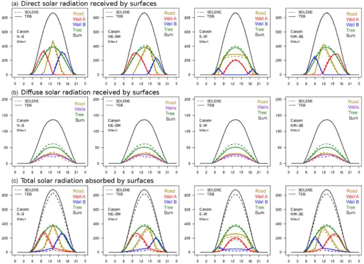
The same evaluations are conducted for vegetated canyons. The statistical scores are computed as previously (see Eqs. 20, 21, 22) but by accounting for the 13 vegetation outs. We also computed additional cases of vegetation lay-outs for the configurations referred to as “h/w=2 rescaled vegetation” (see Sect. 5.2.1 and Fig. 2 for further explana-tions). As an example, a comparison of hourly fluxes is pre-sented in Fig. 6 for the layout A and an aspect ratioh/w=1, and for the summer daily cycle. This configuration is one of the most simple and comparable layouts between the two models: trees are 7.5 m high (i.e., almost the same height as buildings), tree crowns have a 5 m thickness; they are cen-tered in the middle of the canyon and cover 90 % of the canyon width on the horizontal plane.
Table 4.Statistical scores for direct solar radiation received by surfaces before multiple reflections for summertime.
Road Walls Tree
Config. MAD MAPD Bias MAD MAPD Bias MAD MAPD Bias Units W m−2 % W m−2 W m−2 % W m−2 W m−2 % W m−2
No veg. 4.39 1 −0.28 2.49 1 +0.40 – – –
A 9.27 14 +8.73 3.52 5 −1.55 6.22 4 −5.43
B1 11.01 9 +9.11 10.84 6 +2.12 19.22 32 −13.17 B2 23.09 26 +22.51 8.26 8 +2.25 27.71 37 −26.76 B3 16.77 22 +16.47 11.25 20 +10.14 37.07 30 −36.78 B4 20.80 29 +20.42 7.09 8 −0.94 19.44 17 −18.35
C1 9.10 14 +8.55 3.51 5 −1.57 5.96 4 −5.18
C2 13.81 21 +13.47 5.89 9 −4.98 4.13 3 −3.17
C3 8.39 9 +7.79 9.77 16 +8.67 25.58 22 −25.24
C4 11.58 13 +11.15 4.77 4 +1.58 14.13 18 −13.91 D1 11.38 6 +6.40 10.03 5 +1.29 14.95 29 −8.86 D2 15.84 17 +15.29 8.29 8 +2.23 20.52 30 −19.56
D3 6.17 4 +3.90 7.82 4 −1.68 15.14 20 −0.21
D4 19.38 21 +18.62 5.05 5 −3.57 14.10 23 −11.11
Table 5.Statistical scores for diffuse solar radiation received by surfaces before multiple reflections for summertime.
Road Walls Tree
Config. MAD MAPD Bias MAD MAPD Bias MAD MAPD Bias Units W m−2 % W m−2 W m−2 % W m−2 W m−2 % W m−2
No veg. 3.35 7 +0.87 1.70 5 −0.43 – – –
A 1.91 15 +1.37 1.51 9 +1.07 3.51 20 −3.50
B1 2.99 14 +1.91 1.83 8 +1.09 4.10 43 −4.10
B2 4.03 29 +3.79 1.64 7 +0.79 5.38 49 −5.38
B3 3.10 24 +2.75 2.88 27 +2.72 8.22 44 −8.22
B4 3.37 30 +3.21 1.47 6 +0.74 4.71 32 −4.71
C1 1.89 14 +1.31 1.50 11 −0.55 1.73 13 −0.24
C2 1.90 14 +1.35 1.60 4 −0.19 1.94 12 −0.88
C3 2.43 13 +1.52 1.69 12 +1.38 4.36 28 −4.36
C4 2.37 13 +1.50 1.69 5 +0.52 2.61 22 −2.47
D1 2.82 10 +1.31 1.53 3 +0.36 2.05 26 −2.05
D2 3.27 20 +2.73 1.40 5 +0.25 3.25 35 −3.25
D3 2.80 9 +1.10 1.63 3 −0.11 1.20 17 −0.86
D4 3.54 22 +3.07 1.62 5 −0.65 1.84 27 −1.72
tree rows are away from the walls (B1 vs. B2, D1 vs. D2, or D3 vs. D4), contrary to a continuous tree layer occupying almost the entire width of the canyon (A, C1, C2).
As expressed in Eqs. (9) and (10), the diffuse solar radia-tion fluxes received by road and walls (walls are managed to-gether as an average surface), depends on the sky view factor of the given surface and on an attenuation coefficient of the incoming radiation through the foliage. Regarding all sea-sons and configurations combined, the received solar radi-ation by ground-based surfaces is also overestimated while the diffuse solar radiation flux reaching tree crowns is un-derestimated in the TEB simulations (Fig. 7b). Remember that the diffuse solar radiation received by the trees is
Table 6.Statistical scores for total shortwave radiation absorbed by surfaces after multiple reflections for summertime.
Road Walls Tree
Config. MAD MAPD Bias MAD MAPD Bias MAD MAPD Bias Units W m−2 % W m−2 W m−2 % W m−2 W m−2 % W m−2
No veg. 6.03 3 +3.50 3.38 3 +2.80 – – – A 13.30 26 +12.98 9.30 17 +8.84 7.76 5 −2.16 B1 13.31 14 +11.91 11.64 15 +11.19 21.15 28 −16.95 B2 24.27 32 +23.79 10.36 12 +9.61 30.82 38 −29.47 B3 21.82 36 +21.64 21.05 45 +21.04 52.46 35 −50.33 B4 23.13 39 +22.82 9.44 13 +7.81 20.59 17 −17.28 C1 12.04 23 +11.81 5.26 8 +3.98 6.31 5 −0.61 C2 16.15 30 +15.83 3.99 5 −1.43 8.72 7 +4.08 C3 13.23 19 +13.01 16.10 29 +16.10 40.15 29 −37.89 C4 15.95 23 +15.67 9.28 13 +9.15 24.09 21 −19.77 D1 12.45 11 +9.29 8.10 8 +6.78 14.12 24 −8.65 D2 17.19 21 +16.70 8.05 8 +6.73 20.32 27 −18.57
D3 9.09 9 +7.24 5.25 4 +4.02 14.04 14 +0.11
D4 20.06 25 +19.52 4.21 4 +2.09 13.97 22 −9.95
sides and vegetation layouts including two rows where the number of sides is doubled (A vs. B3, C1 vs. C3). Consid-ering the extremely vegetated canyon A, MAPD values are 15, 9 and 20 % for road, walls, and tree, respectively, cor-responding to MAD values of 1.91, 1.51, and 3.51 W m−2 (Table 5). Globally, the estimation of the diffuse solar radia-tion received by the road and walls are acceptable regarding the MAPD, which are≤30 %. However, the relative differ-ences associated with the tree layer are contrasted (from 12 to 49 %), depending on the characteristics of the vegetation layout.
For the same configuration, when comparing TEB results to the SOLENE simulations as reference, the total shortwave radiation absorbed by the different elements of the canyon is simulated with correct daily dynamics (Fig. 6). Despite similar temporal behavior of the fluxes, their magnitudes can greatly diverge, especially for the road and tree surfaces with some MAPD values greater than 30 % and some biases greater than ±25 W m−2 (Table 6). The global scatterplot (Fig. 7c, all seasons and configurations) confirms the trends previously found and the absorbed flux by the trees is un-derestimated. The predictability based on SOLENE results is also weaker (R2=0.954). These poor performances of TEB regarding the statistical scores have to be interpreted with caution. This work aims at evaluating the cost in terms of performances of TEB to simulate a correct allocation of ra-diative fluxes for each facet of the canyon in spite of a simple geometric approach based on cover fractions and a unique view factor per interaction. For example, the tree fraction is computed as a cumulative fraction of all crowns in the street in TEB. Thus, the interactions between tree lines are not al-lowed, contrary to those in SOLENE. However, the conse-quences of some other divergent assumptions can alter TEB scores by the comparison of the absorbed fluxes even if
nei-ther one or the onei-ther model is the truth (as it would have been in observations), and SOLENE can not be considered as the reference simulation for these points. Indeed, the way to cal-culate the transmissivity during multiple reflections is dis-similar between the two models (see Sect. 5.2.3). TEB code computes infinite isotropic reflections using a unique view factor for each facet of the canyon and mean radiative missivity terms. The formulation of the mean radiative trans-missivity terms is based on strong hypotheses on the potential attenuation of rays: they express the ratio between the sec-tor of canyon scanned by the view facsec-tor associated with the studied interaction and the thickness of crown contained in this canyon sector (see Appendix B). In addition, reflections from the high vegetation are constrained upwards in TEB (see Sect. 4.4 and Appendix C for full explanations). On the contrary, SOLENE radiative scheme computes isotropic mul-tiple reflections within the canyon for each triangular mesh, using the radiosity method. The vegetation envelopes here are strictly semitransparent because the penetration of light through the foliage can not be modulated by the leaf area density. Whatever the foliage thickness which is crossed, as soon as a ray reaches a cell of vegetation envelope in SO-LENE, this radiation is attenuated by half.
Figure 6.Comparison of TEB and SOLENE simulations of hourly direct (top) and diffuse (middle) solar radiation fluxes (W m−2) received by urban facets before multiple reflections, and total shortwave radiation fluxes (W m−2) absorbed by urban facets after inter-reflections (bottom) for urban canyons with vegetation. The results are presented here only for the aspect ratio equal to 1 and for the four street orientations during a summer day.
6.4 Benefits of TEB developments
In this section, simulations provided by the initial version of TEB and by the implemented version are compared. For this purpose, we use equations in the new version related to the transmission of radiation fluxes from the high vegetation following the expression presented in Eq. (3), adapted when it required the considered leaf area density (see Appendix B for further details).
6.4.1 Analysis of the behavior of absorbed shortwave radiation per canyon surface
The shortwave radiation received and absorbed by the walls and the road can be strongly affected by the presence of tree vegetation. The comparison between the initial version of TEB which deals with vegetation at ground level, and the new version which explicitly includes an additional tree stra-tum shows differences illustrated in Fig. 8 by taking the
Figure 7.Scatterplots comparing TEB and SOLENE simulations of hourly direct (top) and diffuse (middle) solar radiation fluxes (W m−2) received by facets before multiple reflections, and total shortwave radiation fluxes (W m−2) absorbed by facets after inter-reflections (bottom) for urban canyons with vegetation. Each scatterplot gathers the hourly fluxes simulated for the four seasons, the four aspect ratios, and the four street orientations.
sinceαt=0.25. In the new version, 50 % of the received so-lar radiation is transmitted through the foliage and 75 % of the remaining flux is absorbed by trees, i.e., only 37.5 % of the total shortwave radiation received by trees.
Comparing the fluxes before and after their weighting based on their canyon fraction, the road absorption by squared meters of canyon can extremely vary following the garden fraction at the ground in the initial version. Indeed, in the reference cases, the high vegetation is treated as a ground-based vegetation fraction which is included in the garden fraction (δg). This limitation implies that the garden fraction
takes the value of the greater fraction between low and high vegetation. Consequently, the road fraction, which is always defined as 1−δg, is varying according to the vegetation
lay-out. For example, here, the road fraction is only 0.10. For this experiment, the differences between before and after the weighting of absorbed fluxes by trees is small because the
tree fraction is high (=0.90). In this case, there is no differ-ences for the walls according to the unit of the fluxes since the canyon aspect ratio ish/w=1. For smaller aspect ratios, the fluxes of walls based on the canyon surface will be lower than those calculated by squared meters of wall. On the con-trary, for aspect ratios exceeding 1, the fluxes of walls based on the canyon surface will be higher. The new developments have corrected a systematic overestimation bias in the refer-ence version. This can have a significant impact on the sim-ulation of thermal comfort conditions for pedestrians as well as on energy consumption of buildings for air-conditioning usage.
6.4.2 Analysis of an integrated canyon albedo
The albedo of the canyon (αcan) is calculated as the ratio
Figure 8.Comparison of the total shortwave radiation flux (W m−2) absorbed by road, walls, and tree between the reference TEB simulations without distinction between low and high vegetation, and the new version including an explicit tree canopy corresponding to configuration A within a north–south-oriented canyon with an aspect ratio ofh/w=1 during a summer day. The fluxes are expressed either in W m−2of the considered surface or in W m−2of canyon.
Scan⇓ +Scan↓ and the absorbed radiationScan∗ ) and the total
in-coming shortwave radiation:
αcan=
Scan⇓ +Scan↓
−Scan∗
Scan⇓ +S↓can
. (23)
For each simulation, these fluxes are used at the solar noon in order to compute an instantaneous canyon albedo. The re-sults in summertime are presented as box plots (Fig. 9) that gather all the vegetation layouts, if any, but that distinguish the canyon aspect ratios. Only north–south canyons are rep-resented here. It is a synthetic indicator of TEB enhancement at the scale of the entire canyon, which is crucial when SUR-FEX is run coupled with an atmospheric model such as the research MESO-NH model (Lafore et al., 1997) or the opera-tional model AROME (Seity et al., 2011) to provide climatic simulations.
The aspect ratio has a significant impact on the canyon albedo: the canyon albedo decreases with an increasing as-pect ratio. Since the geometry and radiative properties of the vegetationless canyons and ground-based vegetation canyons in the reference version of TEB are comparable, they provide similar canyon albedos. It is explained by the absence of fo-liage in the vertical plane and identical albedos of road and garden (αr=αg=0.25). For canyons withh/w=0.5 aspect
ratios, the albedo of vegetated canyons with an explicit tree
canopy is systematically lower than unobstructed canyons. Trees can more easily absorb the incoming solar radiation than ground-based surfaces. For higher aspect ratios, the im-pact of trees depends on the balance between their greater sky view factor and reflectivity regarding artificial surfaces and their trapping effect on solar radiation, reducing or in-creasing the total solar energy absorption by the canyon, re-spectively. Note also that their relative impact is lower when the thickness of the crown is proportionally small compared to the height of the buildings. For rescaled vegetation cases in deep streets, we observe a greater variability of canyon albedos compared to the same urban form with thinner tree crowns placed in the lower part of the canyon.
7 Conclusions
In order to investigate some of the physical processes related to the presence of vegetation in an urban environment, e.g., for microclimate, hydrology, or building energy consumption issues, the modeling is definitely a necessary tool.
Figure 9.Comparison of the canyon albedo at solar noon between the reference TEB simulations without distinction between low and high vegetation, and the new version including a tree canopy by aspect ratios for all vegetation layouts combined within north–south-oriented canyons during a summer day. See Sect. 5.2.1 and Fig. 2 for further explanations about theh/w=2 rescaled vegetation configurations.
single view factor for each emitting and receiving surface ap-plied for radiative calculations.
To take into account the tree canopy in TEB, it was how-ever required to add a new vegetated stratum on the verti-cal plane, which can shade the road, the walls, and the low vegetation. This modification led to more complex radiative calculations, but has been done with a concern to preserve a certain level of simplicity and to limit the number of new in-put parameters for TEB. It is important to emphasize that the model is designed to be run over whole cities, for which it can simulate the local climatic variability related to urban land-scape heterogeneities at the neighborhood scale. This means that computing times must be acceptable, and that input ur-ban data must be available or easy to define. Consequently, the high vegetation is described here using only five input parameters: cover fraction of trees, height of trees, height of trunks, leaf area index, and albedo.
This simplified characterization of high vegetation nec-essarily induces some uncertainties on solar radiative changes. We estimated it by carrying out a comparative ex-ercise between TEB and a high-spatial-resolution solar and lighting model (SOLENE). On the basis of an idealized ge-ometry of an urban canyon with various vegetation layouts, TEB is evaluated regarding the total shortwave radiation flux absorbed by the elements that compose the canyon. TEB simulations in summer gathered the best scores for all con-figurations and surfaces considered, which is precisely the most relevant season to assess the cooling effect of deciduous trees under temperate climate. Statistical scores have demon-strated a good capacity of TEB to solve the radiative balance of canyons without vegetation despite the use of a unique sky view factor for each facet of the urban scene. Mean absolute differences and biases of 6.03 and+3.50 W m−2for road,
re-spectively, and of 3.38 and+2.80 W m−2for walls have been recorded in vegetationless canyons. In view of the important incident radiation flux, exceeding 1000 W m−2at solar noon, the mean absolute percentage differences of 3 % for both sur-faces remain moderate. Additionally, it is necessary to put in perspective obtained scores with the fact that they include the error generated by the treatment of walls as a mean wall in TEB in comparison with separate walls in SOLENE con-sidering the diffuse component of the solar radiation. This identified error is no longer existing at the canyon or daily scales. Concerning the vegetated canyons, we noted a high variability of statistical scores depending on the vegetation layout. The greater uncertainties are found for the solar ra-diation fluxes received and absorbed by the high vegetation. The mean absolute difference averaged over the vegetation configurations during summertime is 21.12±13.39 W m−2 or 20.92±10.87 % of mean absolute percentage difference for the total shortwave absorption but these scores are asso-ciated with acceptable biases:−15.96±15.93 W m−2. The systematic underestimation of fluxes reaching the new tree stratum is explained by the cover fraction approach in TEB where sides of the crown are not represented. Interactions be-tween potential tree lines or intra-canopy scattering and trap-ping are also neglected. Presented scores include the effect of divergent approaches in the formulation of the transmis-sion process through trees between TEB and SOLENE even though neither of the two models could be considered as a reference at this stage for this point.
describ-ing the horizontal extent of high vegetation. Infinite reflec-tions within the canyon are also conditioned to the transmis-sivity term calculated per pair of exchanging surfaces. This study demonstrated the enhancement of new developments on the computed absorbed shortwave radiation fluxes within the canyon between the former reference version of TEB and the implemented version. In the current version, trees can in-tercept and absorb the direct solar radiation at the canopy level instead of from the ground. Consequently, the walls and ground are more shaded. High and low vegetation fractions are now explicitly dissociated. The grass and bare soil frac-tions only contribute to the garden fraction. In this way, the road fraction, defined as 1−δg, is independent of the tree
cover. This implies that the weighting of fluxes at the canyon scale has become realistic. The aspect ratio has a significant impact on the canyon albedo: the canyon albedo decreases with an increasing aspect ratio. For canyons withh/w=0.5 aspect ratios, the albedo of vegetated canyons with an ex-plicit tree canopy is systematically lower than unobstructed canyons. Trees within the canyon can more easily absorb the incoming solar radiation than ground-based surfaces. For higher aspect ratios, the impact of trees depends on the bal-ance between their greater sky view factor and reflectivity regarding artificial surfaces and their trapping effect on solar radiation, reducing or increasing the total solar energy ab-sorption by the canyon, respectively. Canyon albedo is also
more vegetation responsive forh/w=1 urban forms or in cases whereh/w=2 canyons when the tree crown thickness is scaled regarding the depth of the street.
The future developments will focus on the separate calcu-lation of turbulent energy fluxes for ground-based and high vegetation. The aerodynamic effect of trees on air flow within the canyon should also be parameterized. The adaptation of TEB to trees taller than buildings will broaden the range of potential neighborhoods to which its tree model could be ap-plied. Based on this more sophisticated version of TEB, new impact studies could be conducted and greening adaptation strategies could be evaluated more precisely.
8 Code availability
Appendix A: Sky view and view factors
Sky view factors for road, garden, and wall (Eqs. A1, A2) as well as the view factors between elements remain unchanged in relation to the initial version of the radiative calculations in TEB (described in Masson, 2000 and Lemonsu et al., 2012):
9rs=9sr=
s
h
w 2
+1−h
w (A1)
9wr=9ws= 1 2
h w+1−
q h w 2 +1 h w (A2)
9sw=1−9sr (A3)
9ww=1−29ws= q
h w
2
+1−1
h w
(A4)
9rw=1−9rs=1− s h w 2
+1−h w
. (A5)
For the tree canopy, the sky view factor and view fac-tors from road and walls are computed in the middle of the canyon and at mid-height of the crown (hcw):
9st=
s
h
w·
h−hcw h
2
+1−
h
w· h−hcw
h
(A6)
9rt= s h w· hcw h 2
+1−
h w· hcw h (A7)
9wt=1−1
2(9st+9rt) . (A8)
9stand9rtare calculated in the same way as9srin the
mid-dle of the canyon but they are adjusted to the [hcw−h] area
and the [0−hcw] area, respectively.9wtis computed as the
complementary term of9stand9rt on 2π and for one wall
(as well as9wsand9ww). We normalized9wt to express it
on oneπ only.
Appendix B: Mean radiative transmissivity of canyon tree canopy
The multiple reflections of solar radiation inside the canyon (as detailed in Masson, 2000 and Lemonsu et al., 2012) are now affected by the presence of trees whose foliage inter-cepts, reflects, and absorbs a part of the energy. The transmis-sivity of radiation through the foliage of tree canopy is vari-able according to the way the rays cross the foliage and the distance they travel. According to the location of tree crowns inside the canyon and the dominant orientation of radiation (e.g., emissions from sky to ground or from wall to ground do not reach the foliage the same way), these rays can cross all the foliage thickness or only a small portion. The vertical
distribution of leaves in the tree crowns also has an impact on transmissivity.
Different transmissivity functions (referred to asτ12 for
exchanges between element 1 and element 2) are calculated depending of the surfaces involved in radiative exchanges. One distinguishes four cases of radiation exchanges by hy-pothesizing that transmissivity functions are symmetric; i.e., exchanges from element 1 to element 2 are equivalent to the reverse way: between ground-based surfaces and sky (τrs=τsg) or wall (τrw=τgw), between wall and sky (τws),
and between wall and wall (τww). For each case, we admit,
according to Lee and Park (2008), that majority of radiation exchanges occur in a specific area of the canyon, for which the leaf area density (LADt, expressed in m2of leaf area per
m3of volume) is calculated:
τrs=1−δt
1−exp
−kR0hLADtdz
(B1)
τrw=1−δt
1−exp
−kR h
2 0 LADtdz
!
(B2)
τws=1−δt
1−exp
−kRh h
2LADtd
z
(B3)
τww=1−δt
1−exp
−kRh
0LADtdz
. (B4)
The limits of integrals involved in the calculation of the transmissivity functions have been consistently defined with canyon sectors scanned by the associated view factors. For example, Eq. (9) expresses how the diffuse incoming solar radiation reaches the road from the sky. This formulation is typically based on the sky view factor of the road9rswhich
scans an area covering the entire height of the building. We added a transmissivity functionτrs describing the ratio
be-tween the thickness of the tree crown within the canyon and the vertical extent of the area of interest, here [0−h].
Note that these expressions are in accordance with the one applied in Eq. (3) in which LADt is integrated on the
en-tire thickness of foliage so that it is equivalent to LAIt. As
mentioned above, since the tree crown is described as a rect-angular parallelepiped with a regular distribution of leaves, a uniform vertical profile of LAD is applied here.
Appendix C: Total shortwave radiation absorption by solving infinite reflections