Impacts of Irrigation and Drought on Salem Ground Water
T. Subramani
1K. Prasath
2P. Velmurugan
3V. Baskaran
4 1Professor & Dean, Department of Civil Engineering, VMKV Engineering College, Vinayaka Missions University, Salem, India
2,3,4
PG Students of Irrigation water resources and management Engineering, Department of Civil Engineering, VMKV Engineering College,Vinayaka Missions University, Salem,
ABSTRACT
This investigation is the first of three phases of a ground-water management study. In this report, effects of irrigation and drought on the ground-water resources of Salem are examined. Irrigation water use for five soil types is estimated from a monthly water budget model on the basis of precipitation and temperature data from the last 30 years at selected weather stations across Salem. Moisture deficits are computed for each soil type on the basis of the water requirements of a corn crop. It is assumed that irrigation is used to make up the moisture deficit in those places where irrigation systems already exist. Irrigation water use from each township with irrigated acreage is added to municipal and industrial ground-water use data and then compared to aquifer potential yields. The spatial analysis is accomplished with a statewide geographic information system. An important distinction is made between the seasonal effects of irrigation water use and the annual or long-term effects. The model is tested for its sensitivity to weather variation; seasonal water deficits are calculated by using data from extreme growing seasons and extended drought periods. The effect of increasing the amount of irrigated land by 50 percent is also considered for normal weather conditions and droughts. The effect of variable irrigation demand on water resources is expressed as the ratio of water use to ground-water potential yield for each township. This is done to highlight regions most susceptible to ground-ground-water stress because of drought or increased irrigation by showing where use could exceed yield. The sensitivity of the results is not tested for variations in spatial aggregation. This will be one of the primary tasks in subsequent study phases. Results show that irrigation is a substantial seasonal consumptive ground water use in Salem, with the potential for growth. However, present effects appear to be localized and highly dependent on weather conditions. Some potential for seasonal or temporary overpumpage may exist in the heavily irrigated areas during years with below-normal precipitation or during extended droughts. The aquifers being used for irrigation appear to have the ability to recover from present irrigation demands without suffering significant depletion, implying that the annual effect of irrigation is currently relatively minimal. The exception to this may be during extended drought periods, especially if widespread expansion of irrigation practices also occurs in the state. A 50 percent expansion of irrigation would appear to have surprisingly little additional impact on ground-water resources under most climatic conditions. That degree of growth around currently irrigated land would result in expanded irrigation areas still within reach of the productive, high-yielding aquifers already being pumped for irrigation. A much larger degree of irrigation expansion into areas with heavier-textured soils is possible in Salem.
KEYWORDS
: Moisture,, Remote sensing, Potential, Ground water Using Gis, Aquifers.I.
INTRODUCTION
The availability and use of ground water in Salem vary widely, both regionally and seasonally. Ground-water resources are abundant, but they are also finite and are not distributed uniformly. As population, industry, and agriculture have grown in Salem, ground water has been increasingly relied on as a ready source for water. But because ground-water resources are limited, conflicts, competition, and shortages of ground water have occurred on occasion.
This has given rise to the recent focus on the need for ground-water management in Salem, especially as it relates to drought planning. Salem has a sub-humid climate with ample mean annual
precipitation ranging from 34 inches in the north to 46 inches in the south. However, precipitation distribution can be very uneven, and prolonged droughts do occur. Droughts of shorter duration during the growing season are also not uncommon. These events are unpredictable and can have wide ranging economic and hydrologic effects, making them particularly important to ground-water planning in Salem. Of particular interest also is the increase in irrigated agriculture and the effect that may have on the ground-water resources of the state.
Although a very small portion of Salem farmland is currently irrigated, that fraction is growing and seasonal consumptive water use by irrigation appears to be substantial. This can cause ground-water
competition, although incidents of conflict in Salem are infrequent and localized.
Given the importance of both ground water and the agricultural economy in Salem, it will be very important to know if there will continue to be enough ground water to sustain a growing irrigation demand without placing a burden on other users, particularly during droughts. There is a clear need to measure, or accurately estimate, the amount of ground water used for irrigation during years with good, bad, and normal weather, and to better understand the implications of a growing irrigation water demand on ground-water resources and future ground-water management objectives.
It is important to protect Salem ground-water resources from depletion, plan for the effects of drought, and help minimize potential conflicts among ground-water users. Increasing irrigation and climate variability need to be considered in future water planning of the state. A three-phase ground-water management study is planned to consider the need for designating ground-water management areas
(GWMA‟s) to address problems of drought and water
competition. The three phases of this ground-water management study are:
1) To gain a better understanding of the stresses on ground-water supplies from drought and increased irrigation
2) To delineate potential ground-water management areas
3) To design an administrative and technical structure for operating ground-water management areas.
1.1THE IMPACT OF IRRIGATION
Irrigation is generally defined as the application of water to the land for the purpose of supplying moisture essential to plant growth. In the process, irrigation projects transform the land in two ways: (1) by direct modifications of the land surface that occur when canal networks are constructed and land is cleared, shaped and levelled for irrigation;
(2) by indirect in-depth transformations that take place when the water and salt balances in the region are changed following the import of additional quantities of water and salt into the area.
1.2 RAINFALL AND CLIMATE
The district receives the rain under the influence of both southwest and northeast monsoons. The northeast monsoon chiefly contributes to the rainfall in the district. Rainfall data from six stations over the period 1901-2003 were utilized and a perusal of the analysis shows that the normal annual rainfall over the district varies from about 800 mm to 1600 mm. It is the minimum around Sankari (800 mm) in the south western part of the district.
It gradually increases towards north, northeast and east and attains a maximum around Yercaud
(1594.3 mm) in the northern part. The district enjoys a tropical climate. The weather is pleasant during the period from November to January. Mornings in general are more humid than the afternoons, with the humidity exceeding 75% on an average. In the period June to November the afternoon humidity exceeds 60% on an average.
In the rest of the year the afternoons are drier, the summer afternoons being the driest. The hot weather begins early in March, the highest temperature being reached in April and May. Weather cools down progressively from about the middle of June and by December, the mean daily maximum temperature drops to 30.2°C, while the meandaily minimum drops to 19.2°C and 19.6°C in January in Salem and Mettur Dam respectively.
II.
GEOMORPHYLOGY AND SOIL
TYPES
2.1 Geomorphology
Salem district forms part of the upland plateau region of Tamil Nadu with many hill ranges, hillocks and undulating terrain with a gentle slope towards east. The prominent geomorphic units identified in the district through interpretation of Satellite imagery are 1) Plateau, 2) Structural hills, 3) Bazada zone, 3) Valley fill, 4) Pediments, 5) Shallow Pediments and 6) Buried Pediments.
A number of hill ranges are located in the northern and north eastern parts of the district, whereas the southern, western and eastern parts of the district are gently undulating and dotted with a few isolated hillocks. The important hill ranges in the district are Yercaud hills, Kanjamalai hills, Godumalai hills and Pachamalai hills.
2.2 Soils
The soils can be broadly classified into 6 major soils types viz., Red insitu, Red Colluvial Soil, Black Soil, Brown Soil, Alluvial and Mixed Soil. Major part of the district is covered by Red insitu and Red Colluvial soils. Block soils are mostly seen in Salem, Attur, Omallur and sankari taluks. Brown Soil occupies major portion of Yercaud and parts of Salem and Omallur taluks and the Alluvial Soil is seen along the river courses in Omallur and Sankari taluks. Mixed soil is occurring only in Attur taluk.
2.3 GROUND WATER SCENARIO 2.3.1 Hydrogeology
deposits comprise boulders, cobbles, gravels, sands and silts and are seen in the foothills of all the major hill ranges.
The thickness of these aquifers ranges from a few meters to as much as 25 m. Ground water occurs under phreatic conditions and is developed by means of dug wells. They are important from ground water development point of view in the hilly terrain. Granite Gneiss, Charnockite, Granites and other associates represent the hard consolidated crystalline rocks. Ground water occurs under phreatic conditions in the weathered mantle and under semi-confined conditions in the fractured zones.
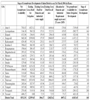
2.4 Ground Water Resources
The ground water resources have been computed jointly by Central Ground Water Board and State Ground & Surface Water Resources and Development Centre (PWD, WRO, Government of Tamil Nadu) as on 31st March 2004. The salient features of the computations are furnished below.
Table 4.2 groundwater development of salem district
2.5 Ground Water Quality
Ground water in phreatic aquifers in Salem district, is in general colorless, odorless and slightly alkaline in nature. The specific electrical conductance
of ground water in phreatic zone (in μ S at 25 o C)
during May 2006 was in the range of 526 to 6040. In major part of the district the electrical conductivity is
above1000 μS/cm, except in Yercaud, P.Goundanpalayam & Salem. Total Hardness is observed in 60% of the samples exceeds more than permissible limit. About 80% of the samples are having high concentration of Nitrate, which may be due to anthropogenic activities. 22% of the samples are having higher concentration of Fluoride (>1.5 mg/L), in parts of Edapadi, Attayampatti &
Jalakandapuram. It is observed that the majority of the samples are characterized by higher concentration of NO³, SO4 and F than the BIS permissible limit. In general, groundwater can be categorized as High Salinity on the basis of SAR and hence proper soil management strategies are to be adopted for major parts of the world.
III.
GROUNDWATER MANAGEMENT
STRATEGY
3.1 Groundwater Development
In view of the comparatively high level of ground water development in the major part of the district and the quality problems due to geogenic and anthropogenic factors, it is necessary to exercise caution while planning further development of available ground water resources in the district. The development of ground water for irrigation in the district is mainly through dug wells tapping the weathered residuum or recent alluvial deposits.
The yields of dug wells are improved at favourable locations by construction of extension bores, which are 40 to 75 m. Deeper bore wells have also become popular as the source for irrigation in the district in recent years.
3.3 GROUNDWATER RELATED ISSUES & PROBLEMS
The development of ground water in the district, in general, is high. As many as 14 out of 20 blocks in the district have been categorised as over exploited or critical . The trend analysis of historical ground water level data also indicates a long-term fall in a major part of the district.
Based on the factors mentioned, it is inferred that a major part of the district could be considered vulnerable to various environmental impacts of water level depletion such as declining ground water levels, drying up of shallow wells, decrease in yield of bore wells and increased expenditure and power consumption for drawing water from progressively greater depths. Incidence of fluoride in ground water in excess of permissible limits for drinking has been reported from parts of the district, especially from the fracture zone. Pollution of ground water due to industrial effluents is another a major problem in the district.
IV.
AWARENESS & TRAINING
ACTIVITY
6.1 Mass Awareness Campaign (MAP) & Water Management Training Programme (WMTP) by CGWB
Two Mass Awareness Campaign on “Ground Water Management, Regulation & Conservation” was
organized in Salem district. The first Campaign was conducted at Sankari during 1999 – 2000 and the second Campaign was conducted at Gangavalli in 2006-07.
The findings of exploration carried out by CGWB, the results of Geophysical investigations for source finding and their limitations, Ground water resource potential of Salem district, Techniques on Ground water resource management and need for regulation and water conservation were explained to the gathering of 350 and 500 people at Sankari and Gangavalli respectively.
One Water Management Training Programme
(WMTP) was organized on “Water Management” at
Attur on 8.11.2006 and 9.11.2006. 40 officers attended the training from various State Government agencies, Representatives of Panchayat Administration, Farmers Association, etc
.
6.2 AREA NOTIFIED BY CGWA/SGWA
Central Ground Water Authority has notified three blocks for registration of ground water abstraction structures owing to very high ground water development in the blocks as given below.
Gangavelli
Talaivasal
Veerapandi
Government of Tamil Nadu vide G.O.No. 53 has restricted groundwater development for irrigation in the over exploited blocks of Tamil Nadu. The over exploited blocks in this district are as follow.
Attur
Ayotiapattinam
Gangavalli
Konganapuram
Magudanchavadi
Mecheri
Nangavalli
Omalur
P.N.Palayam
Panamarathupatti
salem
Talaivasal
Valapadi
Veerapandi
Fig 6.1Ground water
V.
GROUNDWATER IRRIGATION
Groundwater has rapidly emerged to occupy a
dominant place in India‟s agriculture and food
security in recent years. Over the past three decades it has become the main source of growth in irrigated areas, and now accounts for over 60 per cent of the irrigated area in the country. It is estimated that over
70 per cent of India‟s food grain production now
comes from irrigated agriculture in which groundwater plays a dominant role.
Since the growth in groundwater irrigation has not been largely government or policy driven and has happened mainly through highly decentralized private activity, the groundwater revolution has gone by and large unnoticed. However, despite its huge significance and importance, groundwater irrigation is heading for a crisis and needs urgent attention and understanding in India. The number of irrigation blocks labelled as overexploited is increasing at an alarming rate of 5.5 per cent per year.
The number of blocks in which officially the creation of wells must completely stop is scaling new heights every year. Yet, the sinking of new wells continues rapidly, at enormous private, public, and environmental costs. The way India will manage its groundwater resource will clearly have serious implications for the future growth and development of the water resources, agriculture, and food sectors in India, as well as the alleviation of poverty.
VI.
GROUNDWATER QUALITY
PROBLEMS
An in-depth analysis of the hydrogeologic conditions was made. Development of a two-dimensional crosssectional model and subsequent simulations showed that the increase in groundwater salinity in the region except close to coast, was not due to active saltwater intrusion from the sea but due to saline water intrusion from existing saline zones into freshwater zones because of groundwater extraction.
VII.
CONCLUSION
The purpose of this project was to evaluate the effects of drought and increased irrigation on the ground-water resources of Salem. This evaluation was generalized and intended for statewide planning purposes. The results are not suitable for localized interpretation. Given these limitations, the results of seasonal water balance modeling and spatial analyses of soils, land use, and aquifer potential yield lead to several general conclusions.
It appears that irrigation can be a substantial consumptive ground-water use in Salem during the growing season, but its effects are very localized and depend heavily on weather conditions. Some potential for seasonal aquifer over pumpage may exist because of irrigation in some of the heavily irrigated regions during seasons with below normal precipitation, implying the possibility for temporary ground-water use conflicts. For the most part, however, these ground-water supply problems appear to be limited to the growing season.
Natural aquifer recovery compensates for heavy summer irrigation water use over the course of
a year so that on an annual basis, Salem‟ aquifers
appear able to withstand irrigation pumpage without suffering significant, long-term depletion. The exception to this may be in the event of an extended drought when potential aquifer over pumpage appears possible over larger areas of the state. This condition would presumably be temporary, reversing when the drought ends. The other, potentially much more far-reaching exception would be the wholesale expansion of irrigation out of the traditionally irrigated sandy soils and into the much larger portion of the state which has soils of heavier texture.
These are, for example, through credit rationing by NABARD based on the degree of aquifer development, curbing new power connections to bore wells, and time restrictions on electric power supply. The present environmental legislations and regulations are also weak in addressing the environmental impact of groundwater utilization (Briscoe and Malik 2006). The Central Ground Water Board (CGWB) has prepared a model legislation for groundwater regulation.
This has been circulated to state governments and has undergone many revisions. The present version mainly emphasizes regulation, including management and overdraft regulations. These versions, however, contain no provision for ensuring the participation of the local population in the management or in the regulation (Jeet 2005). A major institutional reform would be establishing tradable private property rights in groundwater. This could also empower communities to have rights over the groundwater that they manage, and address issues, such as efficiency, equity, and sustainability (Kumar 2003).
However, bringing about such reforms in water rights would be a complex process because such rights may not always be mutually exclusive (Saleth 1996). If appropriate legal, institutional, and policy regimes exist, local user groups/organizations can emerge in problem areas with support from external agencies, such as NGOs. Some of them can help recognize the rights of individuals and communities over groundwater, and establish tradable private property rights. The present institutional arrangements in India which involve central, state, and local institutions, and both formal and informal structures, are unable to bring about water allocation, planning, and management on a comprehensive or scientific basis.
Bold steps have been taken by many countries in the face of similar challenges that India is facing concerning groundwater ownership. In the early 1980s the legislatures of the American arid states of Arizona and New Mexico replaced the common law/rule of absolute ownership of groundwater, with a government administered permit system of groundwater extraction (The World Bank 1999b).
REFERENCES
[1]. Babaria, N.B., Solanki, M.S., Ardeshana,
A.V. and Barad, V.G. “Quality of Underground Irrigation Waters of Saurashtra Region”.
[3]. Bhatia, Bela (1992). “Lush Fields and Parched Throats: Political Economy of Groundwater in Gujarat”, Economic and Political Weekly, Vol.27, No.51- 52. [4]. Briscoe, J, (1996). “Water Resources Supply
and Management Issues in Chennai (Formerly Madras)”. World Bank:
Washington DC.
[5]. Briscoe, John and Malik, R.P.S. (2006).
“India’s Water Economy: Bracing for a Turbulent Future”. The World Bank. Oxford
University Press, New Delhi.
[6]. Centre for Science and Environment (CSE) 1991. Floods, floodplains and environmental myths. State of India‟s Environment: A Citizens‟ report #3. New Delhi.
[7]. Chambers, Robert; N.C. Saxena; and
Tushaar Shah, (1987). “To the Hands of the Poor: Water and Trees”. Delhi: Oxford and
IBH Publishing Company.
[8]. Chopra, Kanchan, Rao, Hanumantha, C.H. and Sengupta, Ramprasad (Eds.) (2003). Water Resources, Sustainable Livelihoods and Eco-System Services, Concept Publishing Company, New Delhi.
[9]. Dains, S.R. and J.R. Pawar (1987).
“Economic Returns to Irrigation in India”.
New Delhi, Report prepared by SDR Research Groups Inc. for the US Agency for International Development.
[10]. Dhawan, B.D. (1982). “The Development of tube-well irrigation in India”. New Delhi;
Agricole Publishing Academy.
[11]. Dhawan, B.D. (1985). “Output impact according to main irrigation sources: Empirical evidence from four selected States”. Paper presented at the INSA National Seminar on “Water Management: Key to Development of Agriculture,” New
Delhi, 28-30 April 1986.
[12]. Dhawan, B.D. (1993). “Trends and New Tendencies in Indian Irrigated Agriculture”. New Delhi, Commonwealth Publishers.
[13]. Dhawan, B.D. (1995). “Groundwater Depletion, Land Degradation, and Irrigated Agriculture in India”. New Delhi;
Commonwealth Publishers.
[14]. Freeman, D.M., M.K. Lowdermilk, et al.
(1978). “Farm Irrigation constraints and farmer’s responses: Comprehensive field survey in Pakistan”. Fort Collins, Colorado
State University.
[15]. Gandhi, Vasant P. and Namboodiri, N. V.
(2002) „Investment and institutions for water management in India’s agriculture: Profile and behaviour‟, in D. Brennan (ed) Water
Policy Reform: Lessons from Asia and
Australia, Australian Centre for International Agricultural Research (ACIAR), Canberra [16]. Gandhi, Vasant and Ashutosh Roy (2009),
The Performance of Ground-water
Institutions in India: Empirical Study, in Lin Crase and Vasant P. Gandhi Edited, Reforming Institutions in Water Resource Management: Policy and Performance for Sustainable Development, Earthscan: London, forth coming.
[17]. Gandhi, Vasant and Suresh Sharma (2009),
The Performance of Rain-water Harvesting Institutions in India: Empirical Study, in Lin Crase and Vasant P. Gandhi Edited, Reforming Institutions in Water Resource Management: Policy and Performance for Sustainable Development, Earthscan: London, forthcoming.
[18]. Gleick, P. and L. Nash (1991). “The Societal and Environmental Costs of the Continuing California Drought”. Oakland, Pacific
Institute for Studies in Development, Environment and Security.
[19]. Herdt, R.W. and T. Wickham (1978).
“Exploring the gap between potential and actual rice yields: the Philippine case”.