ISSN: 2067-533X
INTERNATIONAL JOURNAL
OFCONSERVATION SCIENCE
Volume 1, Issue 4, October-December 2010: 227-240 www.ijcs.uaic.ro
DUNE ECOSYSTEM MANAGEMENT OF THE
RAZIM-SINOIE LITTORAL BAR (ROMANIA)
Gheorghe ROMANESCU∗
Department of Geography, Alexandru Ioan Cuza University, Bd.Carol I, 20A, 700505, Iaşi, Romania
Abstract
The Razim-Sinoie lagoon complex is located in the south-eastern part of Romania. It is bordered by the Dobrudja region to the west and north, the Danube Delta to the north-east and the Black Sea to the east. An assessment of the quality of dunes was made in that area and several conservation measures were proposed. The age of the Razim-Sinoie littoral bar cannot be older than 1500 – 2000 years, according to to the total closure of the Halmyris bay and the end of the harbour activities in Histria and, subsequently, in Enisala. Transversally, the littoral bar is quite symmetrical, with few differences between the part towards the sea, which is more abrupt, and the less abrupt part towards the lagoon. Most of the sediments that make up the littoral bar are of Danubian origin and the rest are of marine origin (bio-constructional, caused by the smashing of the empty shells). The materials get transported by the littoral stream and deposited by waves and wind. The average increase of the marine level is between 1 and 2 cm/year. Even if the transgressive phenomenon occurs along the entire bar, several sectors are slightly eroded (as in Portita), others are slightly progradated (as in Chituc-Capul Midia) and the rest have a precarious relative equilibrium (Periboina, Periteasca). The reduced water transparency facilitates a good development of the shell population, and causes the terrigenic material/organogenic material ratio (T/O) to be 50/50. As a result of the reduction of the Danube solid discharge which supplied the littoral bar, the whole alignment was affected, and, consequently, a generalized retreat of the shore line occurred. Under such circumstances, a supplementary sediment discharge was necessary, but without affecting the nearby ecosystems. Supplementary material can be brought from offshore, from the – 20m deep isobath or by building canals between the Sfantu Gheorghe arm of the Danube (the southernmost arm) and the littoral nearby. In that case, the old secondary arms and canals: Buhaz-Zaton, Crasnicol and Dranov can be oversized. The shelter dams next to Gura Portita (in the centre) caused important amounts of sediments to be held back, but at the same time a sediment shortage was felt to the south of these dams. In order to stop the littoral erosion and stabilize the dune system, underbrush can be planted, as an indigenous element which develops vigorously in the coastal dune environment.
Keywords: littoral bar; dune ecosystem; management; solid discharge; Black Sea.
Introduction
Although the Danube Delta is one of the most studied landforms on the territory of Romania, the genesis and morphology of the Razim-Sinoie littoral received little attention, as the researches focused mainly on the erosion and accumulation processes along the shore.
∗
In this material we approach two main issues: the genesis and morphology of the littoral bar and, implicitly, of the coastal dunes and dune management in the context of the increasingly aggressive human intervention caused by the development of littoral tourism.
The entire present study, as an integrated study, was unique and it involved measurements and observations over a longer period, as transport and accommodations were not covered by the project.
As human interventions became more aggressive a relevant law enforcement authorities (Administration of the Danube Delta Biosphere Reserve) was required, but also specialists in different fields (geographers, biologists, hydrologists, hydro-technicians, geologists etc.) became involved in preserving the natural balance in the area.
Even if the Danube Delta is a biosphere reservation, unauthorized works, especially on the littoral bar, are still conducted. Under such circumstances, the environmental laws needed to be reconsidered, as the analyzed area was threatened by intense erosion processes.
The coordinates of the Razim-Sinoie lagoon complex are: 44021’30’’ N lat. (Midia Cape), 45002’30’’ N lat. (Agighiol), 28032’40’’ E long. (Tasaul), 29008’30’’ E long. (Gura Dranov) (Fig. 1).
Fig. 1. The geographical location of the Razim-Sinoie lagoon complex
(<2g/l). In the north-eastern sector of the Razim the quantity of clay transported by canals increased significantly [1].
The Razim-Sinoie lagoon complex is located on an abrasion basement, with a wavy appearance, over which the marine or lacustrine-swampy formations were deposited. Subsequently it sank and the water level increased. The Dobrudjan abrasion basement can be found at depth of 14.5m at Jurilovca, 40m in the area of the Portita-Periboina levee, and 52m next to the Dranov lake. Therefore, the abrasion basement follows a west to east and from south-west to north-east slope, towards the deltaic complex.
The depth of the lake is relatively low, around 1.5 – 2m, sometimes even less; very seldom its depth reaches 3m (only in the southern part). An important characteristic is the fact that inside the lake there are several remainders of the predeltaic land, of the inselberg type, with pediments, and they extend far below the water level: Popina (49m), Gradistea, Popinetu (Triassic) and Bisericuta (9m – Cretaceous) [2].
The sedimentary continental material brought in the lagoon complex came from the Danube Delta (through the above mentioned canals), or from the brooks tributary to the lakes. Another part came from the surface erosion produced on the loess type friable material, specific to the Dobrudjan land.
The sediments are made up of calcareous mud, organic mud and calcareous sand with a thickness of 0.3-1.20m. Usually, the sand is coarse and the clay percentage can exceed 15%. A larger proportion of the clay is found in the north-eastern sector of the Razim complex, because of the contribution of the Danube (through the canals linking the arms of the delta). The largest quantity of whole shells, or shell fragments, can be found next to the Dobrudjan shore [1-4]. The quantity and type of sediments depend on the agitation degree of water.
Experimental data
In this study we tried to determine the types of the barrier spit, the classification of the dunes, of the beaches and of the linking passages between the lagoon and the Black Sea. In this respect, we consulted relevant literature in the field for reference: Bird [5-6], Paskoff [7], Pirazzoli [8] etc.
Detailed measurements (height, length) were made in order to point out the differences between the shore affected by progradation and the shore affected by abrasive processes. They revealed the difference between the level of the lagoon water and the sea level.
The measurements were taken over a longer period of time, and they were compared with several topographical maps issued by the Military Topographical Service [9-10].
For comparisons, sand samples were taken both from the typical barrier spits of the Danube Delta, and from the barrier spits that close the Razim-Sinoie lagoon complex. Apart from particle size analysis (which makes the subject of another study), the terrigenic/organogenic ratio was analyzed in order to point out its origin.
For morphological data, modern digital accurate theodolite was used, in order to point out any relevant details. The measurements were compared with the local average see level. As measurement instruments we used tape measures and rulers.
In order to identify the plants growing on the barrier spit, we used the Romanian flora record.
considered as characteristic for the progradation and abrasion models. For each segment several sand samples were taken and an average was determined.
Sand samples were taken from the line of wave breaking (0m).
In addition to the particle size analysis of each sample, the proportion between the terrigenic and the organic material was established.
The intensity of the morphological processes was estimated by measurements between fixed landmarks and the water line. All the elements of the landmark base were used to obtain a database of shore and beach dimensions in points placed at a 1km from one another. The precise location was ensured by the identification of the coordinates x and y within a STEREO/70 system as well as of the z.m. marks within the Black Sea Constanta system.
Results and Discussion
The Razim-Sinoie lagoon complex is the largest lake complex in Romania, and it represents an association of three genetic types of cuvettes [11-12]:
- marine lagoons with one shore, actually representing the old maritime cliff, currently fossilized (the four large lagoons: Razim, Golovita, Zmeica and Sinoie);
- marine limane coasts that occupy the river mouths in the former golf (Calica, Agighiol, Babadag etc);
- lakes between levees, belonging to the group of marine barrier spits situated between the Razim-Sinoie complex and the Black Sea (Cosna, Periteasca, Pahane Ranec, Leahova Mare, Leahova Mica, Edighiolurile etc).
The origin of the Razim-Sinoie lagoon complex is somehow identical to that of the Danube Delta. The genesis of the lake is, therefore, a copy on a smaller scale of the genesis of the Danube Delta:
- the golf stage (Halmyris);
- the lagoon stage;
- the delta stage (or deltaic plain) – the next stage (Fig. 2).
The genesis of the barrier spit, and implicitly of the lagoon, must be associated with the formation and evolution of the Danube Delta. The data obtained so far reveal a Holocene age for the Danube Delta [2, 13-21]. The problem of sequence in time is hard to establish.
According to all the hypotheses issued so far, it seems that during the Atlantic period (the climatic optimum, 5,000-6,000 years ago) the level of the Planetary Ocean raised to a level that favored an intense accumulation of sand on the slope of certain shores. During that period (Fanagorian Transgression?) the level of the Black Sea increased with 3-5m and the first barrier spit, separating the present golf occupied by the Danube Delta, was formed (the Jibrieni, Letea, Caraorman alignment). The deltas studied by Panin indicate an age of 11,000 BC. After that, a secondary delta appeared: Sf.Gheorghe I, Sulina, Sf.Gheorghe II and Chilia, Cosna and Sinoie (next to the lagoon complex Razim-Sinoie).
The Razim-Sinoie barrier spit (the Cosna and Sinoie deltas) appeared as a result of the decapitation of the triangular delta of Sulina (of the “tibru” type). The sediments that the Sf.Gheorghe II delta and the Razim-Sinoie barrier spit are made up of, came from the erosion of the Sulina Delta in the “scissors” system.
Fig. 2 The Sulina Stage (7,200-2,000 years B.P.)
The Razim-Sinoie barrier spit cannot be older than 2,000 years. In the beginning it had the shape of an arrow with the end linked to the southern sector of the Danube. It is older in the northern sector and younger in the southern sector. Its width varies from one place to another, according to the conditions existing in that perimeter. In sectors affected by progradation (Perisor, Chituc) they are more developed, while in sectors affected by erosion (Portita) they are less developed.
The cross section of the barrier spit is relatively symmetrical from one side to the other. On the part exposed to the sea, the slope angle is higher compared to the part exposed to the lagoon, where the slope is smoother.
The sediments that make up the barrier spit are mostly of Danubian origin and of marine origin (of a bioconstructional nature, as shell fragments). The materials are transported by the shore drift and the waves and wind deposit them.
The sedimentary accumulation is made by the waves and currents as well as by various human activities, which are still very reduced in this case. The sedimentary accumulation is done by the longitudinal littoral transfer (drift, shore drift, littoral transfer), by the reconstruction of the summer equilibrium profile (of calm weather) and by coastal hydro-technical constructions.
The Razim-Sinoie barrier spit passed through several evolution stages in the last 2,000 years, as a result of the changing local conditions near the deltaic shore. Apart from the present transgression that occurs on a general scale, reaching values of 1-2mm/year on the Romanian shore, there are other forces involved: sedimentary accumulation processes, the slope of the avant-shore, the factors that contribute either to the abrasion or to the progradation etc. Although the transgressive phenomenon is present over the entire area of the barrier spit, some sectors are slightly eroded (Portita), others are slightly progradated (Chituc-Midia Cape) and in the rest of the sectors there is a precarious relative equilibrium (Periboina, Periteasca). The two opposite phenomena appear as a result of a shortage of sedimentary material in the Portita sector (as a result of closing the Gura Portitei (the Portita Inlet), the accumulation of sedimentary materials coming from the lagoon ceased and the high intensity wind blowing north to south and a north-east to south-west).
In our case, the terrigenic material/organogenic material ratio (T/O) was 50/50 on the entire barrier spit, as compared to the 90/10 ratio for the Sulina-Sahalin sector, 60/40 for Sahalin-Zatoane, 80/20 for Perisor. The reduced turbidity of the water in the sector of the Razim-Sinoie barrier spit causes a rapid growth of the shell population that represents the raw material of beach sediments. The organogenic material represents the CaCO3 accumulation. The aeolian activity, by means of waves and wind, causes the shells to break and transforms them into sand particles. The gradual decrease of the terrigenic accumulation is caused by the distance between this sector and the Danube river mouths. Only a low quantity of the very fine particles are transported there.
The accumulation shore (of a deltaic type) was divided into several sectors, according to morphological characteristics. The Razim-Sinoie barrier spit includes three morphological sectors:
- Perisor – Portita (Periteasca – in the north); - Portita – Chituc (Portita – in the centre); - Chituc – Midia Cape (Chituc – in the south).
The Perisor – Portita sector includes a dune bar behind which small size lakes are found, greatly fragmented and in an advance clogging state.
The Portita – Chituc sector is the most interesting and it is the most representative example of a barrier spit partially closing a lagoon. It had two natural inlets, popularly known as “portite”, “periboine” or “buhazuri” (“buazuri”, “bugazuri” – means “a canal” in Turkish); actually, they represent openings (grau or passe in French, inlet in English) which ensure the communication between the lagoon and the sea. Their genesis may be different (in the case of the Black Sea where tides are not significant):
- they could be created by the passage of the marine currents over the barrier spit, during strong storms, when the waves exceed 6-10m in height:
- they could be generated by the water surplus in the lagoon;
- a previous interruption of the sedimentation in the barrier spit could also be the cause. Unfortunately, both passages underwent modifications:
- in 1960-1974 The Gura Portitei inlet was completely closed, and now its evolution is controlled [24] ;
It is possible that the shelter dams built next to the Portita tourist complex caused the stagnation of important quantities of sediments that were supposed to be deposited in southern sectors. The most obvious withdrawal is manifested in the sector of Gura Portitei (the southern sector – Portita Lighthouse), because an accumulation with sediments from Razim is absent, but also from the north (Periteasca, Perisor) where there is no Danube tributary to feed the barrier spit.
In the sector of the Portita Lighthouse, the barrier spit was reduced with 75m in 20 years, with an average of 3.75 to 4 m per year. The erosion occurred horizontally as well as vertically and, as a result of the latter, a decrease of the sedimentary storage with 70m3/m l (linear meter) occurred.
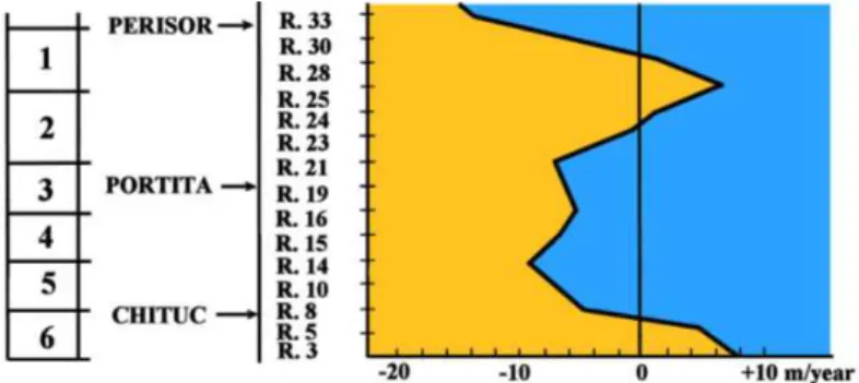
On the barrier spit, during the period 1982-2004 we made 6 measurements: -the accumulation shore in the Perisor sector, at an average rate of +3 - +11 m/year; -shore of moderate erosion between Perisor and Portita sectors, at an average rate of -1 - -6 m/year;
-lagoon barrier in parallel retreat in the Portita sector, at an average rate of -5 - -10 m/year;
-barrier in translation in the Periboina sector, at an average rate of -5 - -10 m/year; -erosion shore between the Periboina and Chituc sectors, at an average rate of -5 – 8 m/year;
-accumulation shore in Chituc sector, at an average rate of +5 - +7 m/year (Fig. 3).
Fig. 3. Behavior of the water line on the barrier spit along of the Razim-Sinoie lagoon
The volume of solid material transported to the south of the Periboina Inlet is higher than that transported to the north, because of the contribution of the solid materials transported by the lagoon current inside the lacustrine complex. As a result of closing the Gura Portitei inlet, the solid discharge through the Periboina Inlet increased. That material built the Chituc barrier spit.
The Chituc – Capul Midia sector is much better represented, and it is the only one that clearly reveals the progradation phenomena. It is made up of two sub-sectors:
- a northern one, with lakes (of the “edighiol” type) situated between the secondary barrier spits, with prolonged shape, with a north east to south west direction;
- a southern one, with a well developed typical accumulation barrier spit, where the width can exceed 5km.
Abrasion is predominant on the Razim-Sinoie barrier spit (on more than 60-70% of the area), while accumulation represents only 30-40%. The hydro-dynamic factors, in natural regime, have a large contribution to the modification of this barrier spit. The anthropic constructions are very rare (shelter dams at Portita and the lock in Periboina) and they do not influence significantly the activity of the natural factors on the shore line.
The width and slope of the beach depend on the quantity of available materials and on the energy of the waves currents that are capable of to transport them [8]. The beach on the Razim-Sinoie barrier spit is poorly developed, and it contains only one single row of prolonged dunes. When the shore is well fed with sedimentary materials and its evolution is long, coastal dune field or prolonged successions of dunes can appear. The interior dunes are older than those closer to the shore.
The low beach of the Razim-Sinoie barrier spit is very extended because it is part of a typical accumulation sector. Sub-aquatic bars and troughs appear on its surface. The high beach includes one or two berms and a row of prolonged dunes known as avant-dunes. Sometimes, small waves of shell fragments appear (of different sizes). Due to the present transgression of the Black Sea, the present shore is continuously withdrawing over almost its entire length (except the northern and southern sector). Erosion and accumulation take place in accordance with Bruun’s law.
The profile of the beach is continuously changing, as it has to adjust itself to the hydro-dynamical conditions that are continuously changing too. The beach lowers when the sedimentary storage diminishes, as a result of erosion caused by storm winds, and it grows, as a result of the accumulation produced in the periods of relatively calm weather with wind. The beach goes through an annual cycle of accumulation and erosion. An objective tendency of the beach (stability, progradation, abrasion) can be predicted only when long term observations are made.
Unfortunately, the general rule of the Razim-Sinoie beach is represented by its withdrawal. In reality, this beach complieswith the average statistics over the world (70% erosion, 20% relative equilibrium, 10% progradation – Bird [6]). The decrease of the total quantity of sediments transported by the Danube (81 mil.t/year in 1894 – Commission Europeenne du Danube [25]; 58.7 mil.t/year – Gastescu, Driga [26]; Bondar [27]; 22 mil.t/year – Duma [28]; Romanescu [20, 22-24]), the increase of the general level of the Black Sea with 1-2mm/year, the intensification of the destructive power of winds etc. are the causes that generate a precarious state of the Razim-Sinoie beach.
The dunes in the first line are border dunes. The small sand accumulations emerge during the warm season, on the high beach, where the remainders of different annual halonitrophic plants represent obstacles for the wind. Their existence is often ephemeral, as they can be swept by the waves of the first storm. The only plants that survive, are those that grow above the highest sea level, behind the perennial psamophyle plants. They have the appearance of low mounds, several decimetres in height, known under the name of nebkas. They have the tendency to grow in a more or less continuous alignment (Fig. 4).
Fig. 4. Scheme of dune formation in the Razim-Sinoie barrier spit
We noticed that the dunes in sectors with a relative equilibrium, or with a certain tendency of accumulation, were situated at a longer distance from the shore (8-10m – Portita). The slope of the avant-dunes in the abrasion sector is higher and often the dunes present terassettes on the beach, with altitudes frequently reaching 1m.
The avant-dunes with relative equilibrium present one or two berms while in the abrasion sectors, these were absent. The psamophyle vegetation installed on those avant-dunes was a pioneer vegetation and it was absent in the areas where shells were predominant.
We should mention the existence of a dune made up exclusively of shell fragments of various sizes. It had a length of 250m and an average width of 20-25m. It was situated 9km north of the Gura Portitei inlet and it was limited from the southern and northern alignment (with predominant shells) by deflation corridors (storm corridors). The dune was recently formed, as inside it, around 20-30cm deep, still green plants were found. Such a shell fragments dune is very rare and that is why it represents a unique phenomenon in the Romanian accumulation shore.
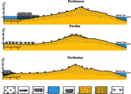
For the sectors Periteasca, Portita and Periboina ideal profiles of the Razim-Sinoie barrier spit were created. The back of the dune, in the Portita sector, is short, as small size and low depth lakes are found nearby, covered with vegetation. Their clogging is advanced and their bottom is situated above the general level of the Black Sea. In the Periteasca sector the back of the dune is very extended, and it turns practically into a sandy area, covered with psamophyle vegetation and with Euphorbia helioscopia. The summits of the avant-dunes contain a large quantity of shell fragments. The barrier spit has a single berm. The Periboina sector, with two berms, extends far behind the avant-dune and its end is situated in lacustrine depressions, strongly clogging (they are usually swamps).
carried to the lacustrine depressions situated between the avant-dune and the dam, and that is why the lakes are strongly clogging. The process is also sped up by the fact that the reef vegetation and the rush vegetation is well developed. On the edge of the lakes, as a result of the saraturation phenomenon, halophyle vegetation frequently grows (Salicornia herbaceea and
Sueda maritima).
Fig. 5. Synthetic profiles in the Razim-Sinoie barrier spit (Periteasca, Portita, Periboina): 1 -Psamophyle vegetation; 2 - Rush; 3 - Reed; 4 - Lakes; 5 - Swamps;
6 - Shells; 7 - Sand; 8 - Euphorbia helioscopia.
The western sector of the barrier spit has an accelerated evolution of progradation towards the lagoon complex, as the vegetation develops very well and facilitates the clogging. The clogging is faster due to the fact that the sand swept away by the wind is kept by the reed vegetation and this vegetation contributes, with a large quantity of organic matter, to the agraddation of the lagoon bottom. After closing the Gura Portitei inlet (1960-1974) the chemical concentration of water changed, from a value of 6-10g/l before the closing, to less than 2g/l today. As a result of the sweetening of the water in the lagoon, the areas covered with reed vegetation extended significantly. After digging up the canals (Dunavat, Dranov, Lipovenilor and Mustaca) that link the Sf.Gheorghe arm with the Razim-Sinoie lagoon complex, the water level increased with more than 30cm. The highest level is in the Razim lagoon. The water level in the Sinoie lake was modified too, but only after the cutting of the V Canal, that allowed the transfer of the drinking water from Golovita to the south.Because drinking water has a lower density than seawater from the Black Sea, but also because the water level in the lagoon complex is higher, a water transfer by means of the phreatic water takes place, from the lagoon to the sea. Theoretically, a slow transfer of sand and clay sediments that make up the barrier spit could also take place.
The decrease in the quantity of alluvia along the shore is cased by the reduction of these alluvia on the Danube, but also on the rivers in the north-western sector of the Black Sea: Dnepr, Dnestr, Bug etc. The multi-annual diagram of the solid discharge variation shows a sudden decrease, with 25-30%, in the period 1970-1972. This variation corresponds with the closing of the Porţile de Fier I (Iron Gates I) Dike. With the construction of the Portile de Fier I and II (on the Danube), the alluvia discharge of the Danube was partially interrupted; around 30 mil t sediments stop annually in the first dike [20, 23, 28].
The present alluvia discharge, especially the sand from the Danube, results especially from the erosion of the sediments belonging to the fluviatile river bed. That can clearly be demonstrated by the gradual increase of the particle size sediments in the river bed upstream of the Portile de Fier I Dike and then Portile de Fier II.
The beach can also be fed artificially, but this procedure is very expensive and laborious. The material used in such a case should be as similar as possible to the material existent on the beach. If the material is too fine, there is a risk of it being dispersed very easily by the waves. The material can be taken from the dunes or from the avant-coast, by dredging; in the latter case the sand is to be taken from a depth of 20m, so that the beach remains undisturbed. The extracted material can be diffused at a lower depth, upstream the chosen place, in order to be transported by the shore drift; in this case, the accumulation on the beach occurs naturally. The dredged material can also be brought to the shore by reffulation pipes (floating or submersed).
If an avant-dune is destroyed, it is advisable that it be recreated in the same place where it was degraded, to restore it in the place where it was affected and to protect it where it is still intact.
In order to re-establish an avant-dune, several psamophyle species can be planted, especially Ammophila arenaria, which is a very good sand fixator. This procedure is very cheap and efficient and it is very adequate to the Romanian littoral. The bushes are arranged perpendicular on the predominant wind direction, and their density should be higher on the maritime side in order to contribute to a better spreading of the sand on the whole dune area. For these bushes to grow faster, fertilizer can be administrated.
If an avant-dune is restored it is very important that it regain the previous natural morphology that represented the result of an equilibrium with the associated beach. It is essential that the avant-dune preserve the same mobility, as its location changes in time, due to the changing of the meteo-marine conditions. The anthropic interventions on the avant-dunes should be led carefully in order to preserve the fragility of the natural equilibrium.
There are several solutions to complete the littoral alluvia deficit:
- the discharge of the alluvia dredged at the “Sulina bar”, near the south of the river mouth; - stopping the short dikes from advancing;
- the deviation of the waters from the Sulina arm through the Imputita brook – using two paths: the Vatafului brook; Busurca canal (this way, a part of the alluvia are directly transported in the abrasive sector, and in the “Sulina bar” silting will slowly occur; the sector next to the Sulina town and next to the short dikes must be periodically dredged in order to maintain a minimum depth of 7.15m);
Fig. 6. Canalization proposals for some secondary deltaic arms, with the purpose of raising the solid discharge at the coastal level: 1 - Lakes; 2 - Canals; 3 - Canalization proposals; 4 - Villages; 5 - Continental land
Conclusions
Because the Razim-Sinoie lagoon copies, on a smaller scale, the genesis and other features of the Danube Delta, it should be included in this morpho-hydrographic unit. Actually, it is included in the Danube Delta Biosphere Reserve.
The Razim-Sinoie lagoon complex occupies the old territory of the Halmyris Golf. This golf was blocked 2,000 years ago by a barrier spit of the “arrow” type. The materials that made up the barrier spit were transported by the north to south shore drift and are of Danubian origin. The genesis of the barrier spit was also facilitated by the decapitation of the Sulina delta (of the “tibru” type).
The sediments of the lagoon complex are made up of calcareous mud, organic mud and calcareous sand, in layers 0.3 to 1.2m, and even thicker.
The barrier spit is penetrated only by two openings called “portite”, “periboine” or “buhazuri” (“bugazuri”, “buazuri” – in Turkish, means “a canal”):the Gura Portitei inlet (artificially closed in 1960-1974) and the Periboina inlet (controlled by a water lock).
The maximum abrasion is recorded in the point of Portita Lighthouse and it has the value of 4.5m/year.
Along the entire barrier spit, the abrasion is predominant (60-70%), while the accumulation sector represents only 30-40%.
The beach of the barrier spit is of the “arrow” type, it is long, continuous and straight. It has two distinct parts: the low beach and the high beach. The profile of the beach is continuously changing as it has to adjust to the hydrodynamic conditions that are continuously changing. On good weather accumulation takes place and during storms erosion occurs.
Razim-Sinoie barrier spit are of avant-dune type and they get the appearance of a levee parallel to the shore. The avant-dunes have an almost symmetrical profile, and they are 2-3m high. They are sporadically fragmented by deflation corridors (storm corridors). The avant-dunes in the sector with a relative equilibrium are situated at a longer distance from the shore (12-15m), compared to those situated in the abrasive sector (8-10m). The shore of the sector with a relative equilibrium has one or two berms, while the abrasive shore does not have such forms, and it is limited by beach terassettes (scarps) with heights up to 1m. They are covered with pioneer psamophyle vegetation. The coastal dune (avant-dune) represents a useful sand reserve for the dynamic equilibrium of the beaches.
Towards the lagoon complex, the lacustrine depressions are intensely clogging with deflation materials and with organic remainders deposited by the hygrophile vegetation, which developed abundantly as a result of the sweetening of waters.
References
[1] G. Romanescu, Lacul Razim – caracterizare sedimentologica, Mediul si Cooperarea transfrontiera, TRANSECO '97, 1997, p. 1-13.
[2] G. Romanescu, Complexul lagunar Razim-Sinoie. Studiu morfohidrografic, Editura Universitatii Alexandru Ioan Cuza, Iasi, 2006.
[3] G. Romanescu, Complexul lagunar Razim-Sinoie. Caracterizare sedimentologica,
Comunicari de Geografie, 4 (2000), p. 169-176.
[4] G. Romanescu, Geomorfologia cordonului litoral Razim-Sinoie, Comunicari de
Geografie, 5, (2001), p. 115-123.
[5] E.C.F. Bird , Coastas, The M.I.T. Press, Cambridge, 1969.
[6] E.C.F. Bird, Coastal changes, a global review, Wiley, Chichester, 1985.
[7] R. Paskoff, Les Littoraux. Impact des aménagements sur leur évolution, Armand Colin, Paris, 1998.
[8] P.A. Pirazzoli, Les littoraux, Éditions Nathan, Paris, 1993.
[9] ***, Hartile topografice in proiectie Gauss, Directia Topografica Militara, Bucuresti, 1952.
[10] ***, Hartile topografice in proiectie Gauss, Directia Topografica Militara, Bucuresti, 1971-1972.
[11] P. Gastescu, Lacurile din Romania, Editura Academiei Romane, Bucuresti, 1971.
[12] A. Breier, Lacurile de pe litoralul romanesc al Marii Negre. Studiu hidrogeografic, Editura Academiei Romane, Bucuresti, 1976.
[13] E. Liteanu, A. Pricăjan, Lithologie et type génetique des depôts du delta du Danube, INQUA, I, Lodz, 1961.
[14] E. Liteanu, A. Pricăjan, Alcătuirea geologică a Deltei Dunării, Hidrobiologia, 4, 1963, p. 57-82.
[15] N. Mihailescu, The evolution of the fluviatile network of the Danube delta in the Pleistocene and Holocene, Travaux du Museum d'Histoire Naturale Gr.Antipa, 30,
1989, p. 355-366.
[16] N. Panin, Histoire quaternare du delta du Danube, Cercetari Marine, I.R.C.M., 4, 1972, p. 5-15.
[17] N. Panin, Black Sea coast line changes in the last 10000 years a new attempt at identifyng the Danube nouths as described ancients, Dacia, 27, 1-2, 1983, p.175-184.
[18] N. Panin, Danube Delta. Genesis, evolution and sedimentology, Rev. Roum. Geol., Gephys., Geol., Geographie, 33, 1989, p.25-36.
[21] G. Romanescu, L'évolution hydrogéomorphologique du delta du Danube. Etape Pleistocène-Holocène inférieur, Z.Geomorph.N.F., Suppl.-Bd. 106, 1996.
[22] G. Romanescu, The Danube Delta – Some Hydromorphodynamic Aspects. Deltaic
changes during the modern and contemporary historical stages, Editura Universitatii Suceava, 1999.
[23] G. Romanescu, Morpho-Hydrographical evolution of the Danube Delta II, Editura TERRA NOSTRA, Iasi, 2005.
[24] ***, Date inedite, Institutul Român de Cercetări Marine, Constanta, 1999.
[25] ***, Commission Europeenne du Danube – son oeuvre de 1856 à 1931, Paris, 1932. [26] P. Gastescu, B. Driga, Évolution du debit liquide a l'embouchure du Danube dans la mer
Noire pendant la période 1850-1980, Rev. Roum. de Géolo., Géophys., Géogr, Serie Géographie, 23, 1982, p. 89-102.
[27] D. Duma, Influente antropice asupra transportului de aluviuni si dinamicii albiilor de raurilor, Simpozionul P.E.A., 2, 1988, p. 67-74
[28] N. Panin, A. Popa, C. Gaita, D. Farnoaga, J.V. Herry, Dinamica sedimentelor pe bratele Dunarii in delta. Modificarile determinate de amenajarile hidrotehnice, Lucrarile celui de al IV-lea Simpozion „Provenienta si Efluenta Aluviunilor”, Piatra Neamt, 1992, p. 57-75.