© Author(s) 2009. This work is distributed under the Creative Commons Attribution 3.0 License.
Earth System
Sciences
Hydrologic and landscape changes in the Middle Ebro River (NE
Spain): implications for restoration and management
A. Cabezas1, F. A. Com´ın1, S. Beguer´ıa2, and M. Trabucchi1
1Pyrenean Institute of Ecology, IPE-CSIC, Zaragoza, Spain 2Aula Dei Experimental Station, EEAD-CSIC, Zaragoza, Spain
Received: 20 August 2008 – Published in Hydrol. Earth Syst. Sci. Discuss.: 30 September 2008 Revised: 5 January 2009 – Accepted: 20 January 2009 – Published: 25 February 2009
Abstract.The changes of landscape (1927–2003), discharge regime and anthropic activities with the river-floodplain of one reach at the Middle Ebro River (NE Spain) were inves-tigated with the objective to identify the factors that best ex-plain the natural ecotope succession and propose a realistic restoration option with consideration of the landscape dy-namics during the last century and the socio-economic con-text. Our results indicate that hydrological and landscape pat-terns have been dramatically changed during the last century as a consequence of human alteration of the fluvial dynam-ics within the studied reach. The magnitude and variability of river discharge events have decreased at the end of the last century, and flood protection structures have disrupted the river floodplain connectivity. As a result, the succesional pathways of riparian ecotopes have been heavily modified because natural rejuvenation no longer takes place, resulting in decreased landscape diversity. It is apparent from these data that floodplain restoration must be incorporated as a sig-nificant factor into river management plans if a more natu-ral functioning wants to be retrieved. The ecotope structure and dynamics of the 1927–1957 period should be adopted as the guiding image, whereas current hydrologic and land-scape (dykes, raised surfaces) patterns should be considered. Under the current socio-economic context, the more realistic option seems to create a dynamic river corridor reallocating dykes and lowering floodplain heights. The extent of this river corridor should adapt to the restored flow regime, al-though periodic economic investments could be an option if the desired self-sustained dynamism is not reached.
Correspondence to:A. Cabezas ([email protected])
1 Introduction
Linking landscape patterns and ecological processes is a common goal of landscape ecology (Forman and Godron, 1986). Landscape ecology holds the potential for develop-ing a truly holistic perspective of river corridors by integrat-ing structure, dynamics and function (Ward et al., 2002). The diversity of landscape units and their spatial distribu-tions in pristine riverine landscapes are the result of geo-morphological and biological processes and interactions op-erating across a wide range of spatio-temporal scales. As a consequence, it was through the interpretation of sequen-tial landscape patterns that the primary drivers of the riverine landscape dynamics have been inferred in different studies (Miller et al., 1995; Hohensinner et al., 2004; Geerling et al., 2006; Whited et al., 2007). A full range of phenom-ena, ranging from catastrophic events to predictable mean flow, generate the fluvial dynamics and fluctuating hydro-logical connectivity that characterizes intact river-floodplain systems (Jungwirth et al., 2002). Riparian succession tends to drive aquatic environments toward terrestrial landscapes, but erosion and deposition during low-frequency floods trun-cate those successional pathways. As a result, in a diverse landscape which contains landscape units at every stage of succession, irregular and anticipated, events drive hydrogeo-morphological functions and, in general, allow the system to remain stable (Amoros and Wade, 1996).
(Tockner and Stanford, 2002). At the Ebro River, in north-east Spain, the promotion of dam construction for irrigation purposes during the last century (Pinilla, 2006), resulted in the accelerated occupation of river margins and massive con-struction of flood protection structures. In the middle stretch of the Ebro, only about 4% of the floodplain is covered by natural vegetation (Ollero, 1992). Regato (1988) reported that natural vegetation had been strongly modified within the Ebro River study reach by alteration of the fluvial dynam-ics; this was later confirmed by Castro et al. (2001). Flood-plain habitats, therefore, must be a critical component of river management for the Water Framework Directive to be successfully applied on the Ebro River.
To achieve the restoration of threatened river systems, a complete understanding of geomorphological and ecological processes is required (Kondolf, 1998). Such an understand-ing will serve as a basis to predict the potential effects of performing site-specific restoration either alone or in combi-nation with flow allocation on a basin-wide scale. In this pa-per, the landscape dynamics of one study reach in the Middle Ebro River are investigated, as well as changes in the natural flow regime and anthropic activities, in order to achieve the next tasks: (a) examine changes in hydrological and land-scape patterns (b) identify the factors that best explain the natural ecotope succession and (c) propose a realistic restora-tion oprestora-tion with considerarestora-tion of the landscape dynamics during the last century and the socio-economic context.
2 Methods
2.1 Study area
The study reach was located in the Middle Ebro River, NE Spain (Fig. 1). This is the largest river in Spain (watershed area=85 362 km2, river length=910 km, average annual discharge to the Mediterranean Sea=14 442 Hm3; 1927–2003) and is still geomorphologically active. Within this section, the average floodplain width is about 5 km. The main channel has a wandering morphology (sin-uosity=1.39, mean channel slope=0.050%, mean chan-nel width=110.31±36.3 m), with elongated meanders and scarcity of in-channel islands. Within the study reach, the daily average discharge is 227.48 m3/s (1927–2003) and the elevation ranges between 175 m a.s.l. in the river channel to 185 m a.s.l. at the base of the scarp. The estimated area that would be inundated by the 10-y flood event (3000 m3/s, 1927–2003) is 2230 ha, although only about 14% of that area would be inundated during a 1000 m3/s flood event (0.37 years return period, 1927–2003), and only 4% would be flooded by a river discharge of 500 m3/s. Upstream of the city of Zaragoza, the catchment area is 40 434 km2and the dam-equivalent capacity is 1637.19 Hm3. The flow regime has changed along the last century at the study reach, as re-flected by the annual average discharge (Fig. 2).
2.2 Hydrological analysis
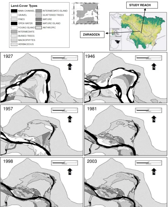
1927 1946
1957 1981
1998 2003 ZARAGOZA
STUDY REACH
Fig. 1.Ecotope maps for a representative part of the study reach, including each of the six years considered in the study. River flow is from
the upper left to lower right. There has been essentially no main channel migration between 1981 and 2003. No significant changes were detected between 1998 and 2003.
inter-period comparisons. Finally, the mean annual discharge at the Zaragoza gauging station was also calculated.
2.3 Landscape analysis
Ecotope maps (Fig. 1) were generated from a set of aerial photographs (1927, 1946, 1957, 1981, 1998 and 2003, all taken at low water levels) to perform a landscape transition
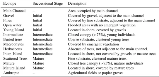
Table 1.Ecotope types used to define landscape units.
Ecotope Successional Stage Description
Main Channel – Area occupied by main channel
Gravel Initial Covered by gravel, adjacent to the main channel Fines Initial Covered by fine substrate, adjacent to the main channel Open water Initial Flooded areas with no emergent vegetation
Young Island Initial Located in-shore, covered by gravels Intermediate Intermediate Closed canopy (>75%), young individuals Buried trees Intermediate Coarse substrate, clustered young trees Macrophytes Intermediate Covered by emergent vegetation
Herbaceous Intermediate Absence of trees, not adjacent to the main channel Inter. Island Intermediate Located in shore, not covered by gravels or mature trees Scattered Trees Mature Fine substrate, clustered mature trees.
Mature Mature Closed tree canopy (>75%), mature individuals Mature Island Mature Located in shore, covered by mature trees Anthropic – Agricultural fields or poplar groves
Fig. 2.Yearly average discharge for the study period (1927–2003)
at the Zaragoza City gauging station. Dash lines indicate the peri-ods when hydrological data was separated for the analysis of flood events.
scanned at 600 dpi, yielding raster images with a pixel resolu-tion from 1 to 2 m. Posiresolu-tional accuracy (n=20) in the studied floodplain averaged 5 m for all georeferenced images. Fi-nally, 1998 and 2003 aerial pictures were supplied by the Aragon Regional Government as georeferenced images with a 1.0 and 0.5 m pixel resolution, respectively.
Three years of field campaigns served as a basis for the identification of ecotope types (Table 1). Landscape units were delimited on the aerial pictures. This method is only applicable if pictures have been taken at comparable water levels. Landscape patches were digitized using ArcGis 9.2® with a fixed scale of 1:3000. At recent aerial pictures (1927– 2003), the ecotope type was assigned to the different units directly on ecotope maps during field campaigns. Since all the study area was surveyed, any ground-truthing statistical test was performed. For the older aerial pictures (1927, 1946, 1957, 1981), landscape units were classified following a sim-ple interpretation-key made from the observed relationships between field ecotopes and map units in the former photos. The key was created using texture, colour, tree density,
ver-tical structure, position in the landscape or previous channel migration dynamics. When possible, a stereoscope was used to exploit the original quality and vertical information of the aerial photos. All patches smaller than 64 m2 were elimi-nated and vector maps were rasterised to a 10×10 m grid us-ing ArcGis 9.2®.
To explore the relationship between landscape structure and river-floodplain interactions, ecotope maps were pro-gressively truncated by increasing the distance to the main channel (considering the thalweg of each year) by 100 m, up to 1000 m, and every 500 m from 1000 to 2500 m. This 2500 m buffer comprises the 10 y floodplain, which has been considered the reference area for the landscape metrics. De-lineation of this reference area was defined by the Ebro River Basin Administration using remote sensing data and ground-truthing during the February 2003 flood, which peaked at 2988 m3/s at the Zaragoza gauging station (Losada et al., 2004). For all buffers considered in this study, Fragstats 3.3 (McGarigal and Marks, 1995) was used to calculate the area and percentage of land occupied by each ecotope category, as well as ecotope diversity using the Shannon Index. The Shannon Index (H) is commonly used to measure biolog-ical diversity in categorbiolog-ical data. This index considers the number of species the evenness of each specie, calculated as followsH=−Pp∗ilnpi (pi: ecotope proportion of typei).
It has been widely applied in landscape studies (McGarigal and Marks, 1995). Cumulative diversity spectra, consider-ing buffers progressively further from the main channel, were plotted. The shape of the spectra is expected to indicate spa-tial distribution of ecotope diversity, and so the effect of a more active fluvial dynamic or anthropic occupation of the outer floodplain. On the other hand, diversity at the 2500 m buffer indicates the total landscape diversity.
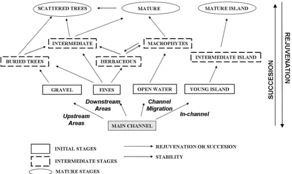
Fig. 3.Ecotope succession scheme. See explanations in the text (Methods section).
Kilimanjaro® (CrossTab). A general ecotope succession model (Fig. 3) was then created from the interpretation of transition matrices and previous research on vegetation dy-namics (Braun Blanquet and de Bol´os, 1987; Regato, 1988). In this scheme (Fig. 3) arrows between natural ecotopes (all ecotopes less “anthropic”) indicate the linear trend to-wards more mature ecotopes of riparian succession. Ev-ery ecotope transition was classified either as Natural transi-tions or as Human-affected transition. Natural transitransi-tions are those between natural ecotopes (e.g. “main channel” towards “gravel”), which were classified as succession (SUC), reju-venation (REJ) or stability (STA) according to the succes-sion model: transitions between ecotopes at the same stage (initial, intermediate or mature in Fig. 3) were considered as STA; those transitions between ecotopes at different stage were considered as SUC or REJ depending on the direction (Fig. 3), also reflecting the possibility of direct transitions by any ecotope at mature and initial stages. Finally, human-affected transitions were those from a natural ecotopes to-wards the “anthropic” ecotope type. Using the cartographic ecotope data from the previous year, we determined how eco-tope types developed from the initial patchwork. For this analysis, the importance (%) of SUC, REJ and STA (Natural transitions) during the analysed snap-shots was represented in triangular ternary plots as recently constructed by Geerling et al. (2006). Human-affected transitions were consequently discarded for this analysis. For an easier interpretation of the results, the transitions were later grouped into the three time periods in accordance with the hydrological analysis: (a) 1927–1957, transitions 1 and 2, (b) 1957–1981, transi-tion 3 and (c) 1981–2003, transitransi-tions 4 and 5.
Fig. 4.Magnitude-frequency plots illustrating reduced frequency of
high-discharge events in more recent years.
3 Results
3.1 Hydrological analysis
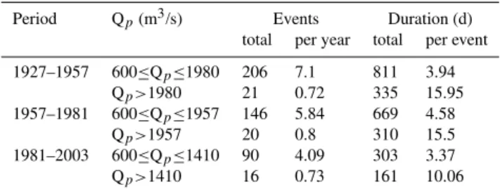
Table 2. Number, frequency and duration of flood events at the Zaragoza gauging station. Data were analyzed separately for the three temporal periods. Flood events were considered if ex-ceeds 600 m3/s and categorized according to the estimated bankfull discharge (1927–1957=1980 m3/s; 1957–1981=1957 m3/s; 1981– 2003=1410 m3/s). Qp=Flood magnitude.
Period Qp(m3/s) Events Duration (d)
total per year total per event
1927–1957 600≤Qp≤1980 206 7.1 811 3.94
Qp>1980 21 0.72 335 15.95
1957–1981 600≤Qp≤1957 146 5.84 669 4.58
Qp>1957 20 0.8 310 15.5
1981–2003 600≤Qp≤1410 90 4.09 303 3.37
Qp>1410 16 0.73 161 10.06
periodicity declined. For example, a 3000 m3/s event, which served to delimit the floodplain area, had a recurrence time of 8 y and 10 y in the periods 1927–1957 and 1957–1981, respectively. From 1981 and 2003, however, the frequency of an event of that magnitude decreased, with a recurrence time of 60 years. Similarly, the bankfull discharge dropped slightly from 1980 to 1917 m3/s between the first and the sec-ond time periods, but diminished substantially to 1410 m3/s in the 1981 to 2003 period. The number of flood events in which the peak exceeded the bankfull discharge has de-creased since 1981 (Table 2) although no real drop was vis-ible in the per year occurrence. Also the duration of these flood events were higher before 1981. With regards to the floods that peaked below bankfull discharge, the number and frequency have progressively dropped during the study riod, going from 206 sub-peak events in the 1927–1957 pe-riod (7.10 events per year), to only 90 such events in the 1981–2003 period (4.09 events per year). However, dura-tion of sub-peak events have oscillated, reaching a maximum (4.58 d per event) in the 1957–1981 period, and a minimum (3.37 d per event) in the most recent period, showing no clear trends.
3.2 Landscape analysis
Ecotope maps show how drastically the landscape structure has changed from 1927 to 2003 (Fig. 1). Ecotope diversity has decreased over that same period. The Shannon Diversity index (H) of the entire floodplain area, which corresponds to the 2500 m buffer, dropped from 1.78 in 1927 and 1946 to 1.08 in 1998 and 2003 (Fig. 5). In 1981, this index was slightly lower than in 1998. In addition, there has been a spatial change in ecotope diversity within the floodplain rel-ative to proximity of the main river channel. Prior to 1981, ecotope diversity peaked at a distance of 200–300 m from the river bank and then decreased with increasing distance from the river; the 1946 spectra shows a secondary, though slight, peak at 900 m. However, the 1981, 1998 and 2003
Fig. 5.Ecotope diversity as a function of distance to the river
chan-nel. Note that 1998 and 2003 plots are superimposed.
data show maximum ecotope diversity at just 100 m from the main channel, followed by a rapid and steep drop.
Elongated meanders were present in the 1927 maps, but these oxbow channels were cut-off before 1946 (Fig. 1). Lat-eral accretion caused the main channel to migrate between 1946 and 1981, and established its current location. The area of the main channel decreased over the study period (8.24% in 1927 to 5.33% in 2003, Table 3), whereas human-occupation of the river space has markedly increased in im-portance, especially between 1946 and 1981. This change appears true not only for the outer margins of the floodplain, where incremental impacts would be expected and domi-nated by intermediate and mature ecotopes (Fig. 1), but also for the natural riparian corridor, adjacent to the main chan-nel, which has narrowed considerably (Fig. 1). On the con-trary, the percentage occupied by natural ecotopes has de-creased from 49.5% to 26.4% during the study period (Ta-ble 3). Mature ecotopes maintain their importance despite such decreased, although it was lower between 1946 and 1981. On the other hand, the portion covered by initial and intermediate ecotopes drastically drop during the examined period.
and “intermediate island”. Finally, about the 30% of the patches occupied either by “scattered trees” or “mature” were renewed progressively between 1927 and 1957, while STA dominated for the remainder patches. From 1957 to 1981, trends were similar to those in previous period for “open wa-ter” and “gravel”, but SUC became dominant for “fines” and “young island”. For intermediate stages, SUC also emerged as the dominant process, although REJ was also important. Referring to mature ecotopes, rejuvenation at areas adja-cent to the main channel (around 50%) and anthropization in the outer floodplain (Table 3) restricted the establishment of “scattered trees” and “mature”. Finally, all ecotope types showed a slight trend towards STA between 1981 and 1998, with the exception of “island” ecotopes. During this period, REJ became nearly nonexistent (Fig. 6). Moreover, all eco-topes showed increasing signs of stability after 1998, despite the potential erosive effect of a 10 y flood (1927–2003 data) in February 2003.
4 Discussion
4.1 Changes in hydrological and landscape patterns Over the last century, the natural flow regime in the Mid-dle Ebro River has been modified by progressive river flow regulation and anthropization of the catchment area. During the last part of the century, discharge magnitude and vari-ability have markedly decreased (Figs. 2 and 4). Accord-ing to our analysis, the mean annual discharge within the study reach has declined approximately 30% since 1981, co-inciding with the decrease of bankfull discharge. Various researchers have suggested that this phenomenon has been caused by the progressive increase of evapotranspiration due to higher temperatures, reforestation of abandoned agricul-tural fields in mountainous areas, increase in reservoir wa-ter storage (volume and surface area) and the expansion of irrigated farmlands (Iba˜nez et al., 1996; Ollero, 2007). In basin areas upstream of the study reach, a sharp increase in the total equivalent capacity of reservoirs occurred between 1950 and 1980, in parallel with the expansion of irrigated land. However, the emphasis on agricultural production since the 1980’s was driven to a large degree by the cultivation of water-hungry crops such as rice, fruits or vegetables (Frutos et al., 2004). In addition to this increased demand, precipita-tion peaked during the 1970s in nearly all of the Ebro Basin (Abaurrea et al., 2002), which may have helped to dampen the effect of human impacts on the system. Flood events, flow and flood pulses (see Tockner et al., 2000) have shown distinct patterns of change in their frequency and duration (Table 2). Our analysis detected that events above the bank-full discharge decreased in duration but not in number since 1981, while those below bankfull discharge decreased only in number. The management of the largest reservoirs for ir-rigation purposes might explain those trends. In winter, the
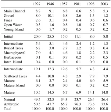
Table 3.Area (%) covered by each ecotope in each year.
Percent-ages are calculated for the total floodplain area (2230 Ha). Sub-totals by succesional stage (see Table 1) are also displayed.
1927 1946 1957 1981 1998 2003
Main Channel 8.2 9.1 6.8 6.6 5.3 5.3 Gravel 8.0 10.1 6.8 2.6 1.3 1.2 Fines 2.6 3.1 0.4 0.4 0.6 0.6 Open Water 0.5 1.6 0.8 1.0 0.7 0.7 Young Island 0.6 1.7 0.2 0.5 0.2 0.2
Initial 20.0 25.5 15.0 11.1 8.0 8.0
Intermediate 5.4 5.1 4.6 2.4 1.2 1.3 Buried Trees 6.2 3.0 2.7 1.2 0.3 0.4 Macrophytes0 7.0 4.1 4.6 1.8 2.2 2.3 Herbaceous 0.1 0.1 0.7 0.2 0.5 0.5 Inter. Island 0.4 0.0 0.0 0.1 0.0 0.0
Intermediate 19.1 12.3 12.6 5.7 4.3 4.4
Scattered Trees 4.4 10.8 4.3 2.9 7.9 7.9 Mature 6.1 3.7 2.4 4.0 6.0 5.9 Mature Island 0.0 0.0 0.0 0.1 0.2 0.2
Mature 10.5 14.5 6.7 6.9 14.1 14.0
Natural 49.5 52.3 34.3 23.7 26.4 26.4 Anthropic 50.5 47.7 65.7 76.3 73.6 73.6 Total 100.0 100.0 100.0 100.0 100.0 100.0
number of floods is dampened using the existing flood con-trol infrastructure in order to store water for summer, when irrigation demand is high. Given the winter storage goals, the capacity of flood-control systems to mitigate large floods in early spring, when the snowmelt occurs, is minimal. This has been previously described for dams located in the Pyre-nees, which are often at or near capacity at the onset of spring floods (Lopez-Moreno et al., 2002).
to anthropic ecotopes proceed almost entirely from 1946 to 1981, resulting in a two fold increase of the area covered by human managed ecotopes (Table 3). After abandonment, some of those human-manages patches have been covered by natural vegetation, what explains the slight increase of ecotope diversity since 1981 (Fig. 5). Since magnitude of river flow and fluctuations in river discharge between 1957 and 1981 did not greatly differ from the previous period of 1927 to 1957 (Fig. 4), it was the extensive implementation of flood protection structures along the river banks that was the most likely factor disrupting river-floodplain interactions, accelerating succession towards mature stages (Fig. 1). Al-though defences have been constructed along the Ebro River for centuries (Ollero, 2007), within the study reach almost all modern and effective flood protection structures were built between 1960 and 1980 (Ollero, 1992), and they are rein-forced after every large flood.
4.2 Natural ecotope succession
Human alteration of river-floodplain interactions, which oc-curred sequentially, prevailed over the natural drivers of floodplain dynamics since 1957. This promoted a different ecotope dynamics, as well as distinct initial conditions, for each time period considered in this study: (a) Channel Mi-gration (1927–1957): unmodified flow regime and absence of flood protection, high conversion to anthropic landcov-ers took place at least since 1946, (b) Vertical Accretion (1957–1981): unmodified flow regime but establishment of flood protection (Ollero, 1992), high rates of conversion to anthropic landcovers and (c) Homogenization (1981–2003): modified flood regime and dyke construction, conversion to anthropic ecotopes with a great reduction in natural ecotopes. During the first phase (1927–1957), the river-floodplain interactions during flow pulses not only stabilized part of the area occupied by initial and intermediate ecotopes, but also compromised the ongoing succession through main chan-nel migration. Flood scouring forced larger patches of ma-ture ecotopes to be located at the outer floodplain (Fig. 1), whereas flood events were sufficiently robust to rejuvenate mature patches located adjacent to the main channel (Fig. 6). Between 1946 and 1957, the elevated river-floodplain con-nectivity allowed for rapid readjustments to disturbances within the watershed, which explains the differences be-tween initial and intermediate ecotope areas bebe-tween 1946 and 1957 (Table 3).
During the second phase (1957–1981), river-floodplain in-teractions were strong enough to allow channel migration before the main channel adjusted to its “straitjacket” (sensu Lamers et al., 2006), and therefore, rejuvenation occurred at every successional stage (Fig. 6). The intense conversion to human-managed ecotopes restricted natural patches to the river corridor (Fig. 1), while lateral accretion was progres-sively constrained by dyke construction. As a consequence, succession was probably accelerated by higher vertical
ac-cretion rates. Steiger et al. (2001) described this trend for a riparian area over a 30-y period in the Garonne river.
During the last period (1981–2003), the synergic effect of a modified flow regime and flood protection impeded eco-tope rejuvenation, with the exception of in-channel ecoeco-topes (Fig. 6). Between 1981 and 1998, the effect of non-erosive floods caused succession to proceed for the initial and in-termediate ecotopes, resulting in the dominance of mature ecotopes at the end of the period (Table 3). The last exam-ined transition period (1998–2003) revealed strong system stability (Fig. 6), despite the potential effects of a 3000 m3/s (60 y; 1981–2003) in February 2003. According to Amoros and Wade (1996), tremendous quantities of external energy are required to revert succession because in mature ecotopes succession is driven by autogenic processes. Indeed, only bank erosion at localized points was detected between 1998 and 2003.
4.3 Restoration options for the study reach
Prior to suggest feasible restoration guidelines, it is nec-essary to consider the current socio-economic context both at basin and reach scale. At basin scale, alternative strate-gies would need a more integrated use of natural resources, consisting primarily of soil and water (Com´ın, 1999). Be-yond that, however, the current land uses within the Ebro Basin territory must also be integrated into a management plan, as performed for other threatened floodplains (Hale and Adams, 2007). At present, 80% of the Ebro water demand is diverted for agriculture and farming (Frutos, 2004), ac-counting for about 40% of the mean annual discharge. This trend is not likely to be changed because of further irrigation development is planned (www.chebro.es). At reach scale, public reclamation of agricultural lands for restoration pur-poses seems possible. The average age of landholders has increased through time, and a high percentage of the crops are only profitable due to agricultural subsidies. With regards to flood protection structures, decisions concerning on dyke reallocation rely entirely on the Ebro Basin administration.
Table 4.Area (%) covered by each natural ecotope for the array of natural landforms. Percentages are calculated for the area occupied by natural ecotopes (all less “anthropic”). Sub-totals by succesional stage (see Table 1) are also displayed.
1927 1946 1957 1981 1998 2003
Main Channel 16.3 17.4 19.9 28.0 19.8 20.2 Gravel 16.1 19.2 20.0 11.0 4.9 4.5 Fines 5.3 6.0 1.2 1.6 2.3 2.3 Open Water 1.0 3.1 2.4 4.3 2.6 2.8 Young Island 1.7 3.2 0.5 1.9 0.7 0.7
Initial 40.3 48.8 43.9 46.8 30.3 30.3
Intermediate 11.0 9.7 13.4 10.2 4.6 4.8 Buried Trees 12.5 5.8 7.8 5.1 1.1 1.3 Macrophytes0 14.2 7.9 13.4 7.7 8.5 8.5 Herbaceous 0.1 0.2 2.1 0.8 2.0 1.9 Inter. Island 0.8 0.0 0.0 0.2 0.1 0.1
Intermediate 38.5 23.5 36.7 24.1 16.3 16.7
Scattered Trees 8.8 20.6 12.5 12.2 29.9 29.8 Mature 12.3 7.1 6.9 16.7 22.8 22.5 Mature Island 0.0 0.0 0.0 0.2 0.7 0.7
Mature 21.2 27.7 19.4 29.1 53.4 53.0 Total 100.0 100.0 100.0 100.0 100.0 100.0
should mimic those observed between 1927 and 1957 for nat-ural ecotopes (Fig. 6).
To successfully restore the study reach towards this guid-ing image, previous research has to be implemented because current geomorphological and ecological processes are ex-pected to differ from those at the beginning of the last cen-tury. The effect of modifying topography on the erosive ca-pability of floods, and so over landscape dynamics, has to be first investigated by modelling surface flows. It allows pre-dicting the effect of removing dykes or lowering floodplain heights at a specific area. Such actions would need an initial economic investment, which will be required to be periodic if the self-sustained dynamism is not reached within the dy-namic corridor. This strategy has been proposed as a valid compromise between the need for flood protection and the growing demand for ecosystem rehabilitation in highly regu-lated rivers (Baptist et al., 2004). Similarly, the modification of different components of the flow regime has to be evalu-ated. Efforts should focus on evaluation the effect of restor-ing some components of the flow regime (frequency, dura-tion, timing, rate of change) since that will more likely in-fluence riparian vegetation growth and establishment (Poff et al., 1997; Bendix and Hupp, 2000; Hughes and Rood, 2003; Stromberg et al., 2007). Finally, the management of fine-grained sediment dynamics is an urgent priority, as indicated by others (Owens et al., 2005; Rovira and Iba˜nez, 2007), if a more natural geomorphological functioning wants to be achieved. The delivery in the system of sediments belonging from lowering floodplain heights should be also evaluated as a restoration tool.
5 Conclusions
Flow regulation, human occupation and construction of flood protection structures have modified landscape structure and dynamics in the study reach. At present, the fluvial landscape is less diverse and dominated by mature stages and anthopic ecotopes, river-floodplain interactions are counteracted by dykes, and hydrological patterns are different, in terms of pulses of the river discharge, to those observed prior to river regulation (1927–1957). It seems, therefore, that a more natural functioning of the river-floodplain system should be achieved through ecological restoration. To accomplish this goal, ecotope diversity and dynamics observed between 1927 and 1957 is a valid reference situation. When implementing restoration, managers should consider the current hydrolog-ical and landscape constraints (dykes, vegetation encroach-ment, and raised surfaces) and the socio-economic context at basin and reach scale. The more realistic option is cre-ating a dynamic river corridor whose extent should adapt to the restored flow regime. An initial economic inversion is necessary to reallocate dykes and lowering floodplain height; however, it might be required periodically if self-sustained restoration is not achieved within this dynamic river corridor. Acknowledgements. The research was funded by the Department of the Environmental Science, Technology and University – Aragon government (Research group E-61 on Ecological Restoration) – and MEC (CGL2005-07059). The Spanish Research Council (CSIC) granted Alvaro Cabezas through the I3P program (I3P-EPD2003-2), which was financed by European Social Funds (UE). Thanks are extended to Alfredo Ollero for his collaboration with the flood protection data, and to Paz Errea and Jesus Martinez for their indispensable help with the GIS software.
Edited by: A. Butturini
References
Abaurrea, J., As´ın, J., and Centellea, A.: Caracterizaci´on espacio-temporal de la evoluci´on de la precipitaci´on anual en la cuenca del Ebro, in: El agua y el Clima, edited by: Guijarro, J. A., Gri-malt, M., Laita, M., and Alonso, S.:, Publicaciones de la Aso-ciaci´on Espa˜nola de Climatolog´ıa, 113–124, 2002.
Amoros, C. and Wade, P. M.: Ecological succesions, in: Fluvial Hydrosystems, edited by: Petts, G. E., and Amoros, C., Chapman & Hall, London, 211–241, 1996.
Baptist, M. J., Penning, W. E., Duel, H., Smits, A. J. M., Geerling, G. W., van der Lee, G. E. M., and Van Alphen, J. S. L.: As-sessment of the effects of cyclic floodplain rejuvenation on flood levels and biodiversity along the Rhine river, River Res. Appl., 20, 285–297, 2004.
Begueria, S.: Uncertainties in partial duration series modelling of extremes related to the choice of the threshold value, J. Hydrol., 303, 215–230, 2005.
Braun-Blanquet, J. and de Bol`os, O.: Las comunidades vegetales de la depresi´on del Ebro y su dinamismo, Delegaci´on Medio Ambi-ente – Ayuntamiento de Zaragoza, Zaragoza, 278 pp., 1987. Castro, P., Guerrero, J., and Mu˜noz, M. A.: Plan de Restauraci´on
del Bosque de Ribera en la Reserva Natural de los Galachos (Zaragoza), Investigacion, Consejo de Proteccion de la Natu-raleza de Aragon, Zaragoza, 165 pp., 2001.
Com´ın, F. A.: Management of the Ebro River Basin: Past, present and future, Water Sci. Technol., 40, 161–168, 1999.
Cunnane, C.: A particular comparison of annual maxima and partial duration series methods of flood frequency prediction, J. Hydrol., 18, 257–271, 1973.
Dury, G. H.: Magnitude-Frequency analysis and Channel Morphol-ogy, in: Fluvial GeomorpholMorphol-ogy, edited by: Morisawa, M., Allen and Unwin, London, 91–121, 1981.
Forman, R. T. T. and Godron, M.: Landscape Ecology, John Wiley and Sons, New York, 1986.
Frutos, L. M., Ollero, A., and S´anchez Fabre, M.: Caracteri-zaci´on del Ebro y su cuenca y variaciones en su comportamiento hidrol´ogico, in: Alteraci´on de los regimenes fluviales peninsu-lares, edited by: Gil Oncina, A., Fundaci´on Caja Murcia, Ali-cante, 223–280, 2004.
Geerling, G. W., Ragas, A. M. J., Leuven, R., van den Berg, J. H., Breedveld, M., Liefhebber, D., and Smits, A. J. M.: Succession and rejuvenation in floodplains along the river Allier (France), Hydrobiologia, 565, 71–86, 2006.
Hale, B. W. and Adams, M. S.: Ecosystem management and the conservation of river-floodplain systems, Landscape Urban Plan., 80, 23–33, 2007.
Hohensinner, S., Habersack, H., Jungwirth, M., and Zauner, G.: Reconstruction of the characteristics of a natural alluvial river-floodplain system and hydromorphological changes following human modifications: The Danube River (1812–1991), River Res. Appl., 20, 25–41, 2004.
Hughes, F. M. R. and Rood, S. B.: Allocation of river flows for restoration of floodplain forest ecosystems: A review of ap-proaches and their applicability in Europe, Environ. Manage., 32, 12–33, 2003.
Iba˜nez, C., Prat, N., and Canicio, A.: Changes in the hydrology and sediment transport produced by large dams on the lower Ebro river and its estuary, Regul. Rivers Res. Manag., 12, 51–62, 1996. Jungwirth, M., Muhar, S., and Schmutz, S.: Re-establishing and as-sessing ecological integrity in riverine landscapes, Freshw. Biol., 47, 867–887, 2002.
Junk, W. J., Bayley, B., and Sparks, R. E.: The flood pulse concept in river-floodplain systems, in: Proc. Intern. Large River Sym-posium, Special Issue of J. Canad. Fish. Aquat. Sci., edited by: Dodge, D. P., 106, 11–27, 1989.
Kondolf, G. M.: Lessons learned from river restoration projects in California, Aquat. Conserv., 8, 39–52, 1998.
Lamers, L. P. M., Loeb, R., Antheunisse, A. M., Miletto, M., Lu-cassen, E. C. H. E. T., Boxman, A. W., Smolders, A. J. P., and Roelofs, J. G. M.: Biogeochemical constraints on the ecological rehabilitation of wetland vegetation in river floodplains, Hydro-biologia, 565, 165–186, 2006.
Lopez-Moreno, J. I., Begueria, S., and Garcia-Ruiz, J. M.: Influ-ence of the Yesa reservoir on floods of the Aragon River, central Spanish Pyrenees, Hydrol. Earth. Syst. Sci., 6, 753–762, 2002.
Losada, J. A., Montesinos, S., Omedas, M., Garcia, M. A., and Gal-van, R.: Cartograf´ıa de las inundaciones del R´ıo Ebro en Febrero de 2003: Trabajos de Fotointerpretaci´on, teledetecci´on y analisis SIG en el GIS-EBRO, Metods Cuantitativos, SIG y Teledetec-cion., Murcia, 207–218, 2004.
Miller, J. R., Schulz, T. T., Hobbs, N. T., Wilson, K. R., Schrupp, D. L., and Baker, W. L.: Changes in landscape structure of a southestearn Wyoming riparian zone following shifts in stream dynamics, Biol. Conserv., 72, 371–379, 1995.
McGarigal, K. and Marks, B.: FRAGSTATS: Spatial Analysis Pro-gram for Quantifiying Landscape Structure, USDA For. Serv. Gen. Tech. Rep. PNW-351., 1995.
Ollero, A.: Los meandros libres del Ebro medio (Logro˜no-La Zaida): geomorfolog´ıa fluvial, ecogeograf´ıa y riesgos., Dep. Ge-ograf´ıa y Ordenaci´on del Territorio, Universidad de Zaragoza, Zaragoza, 1992.
Ollero, A.: Din´amica reciente del cauce de el Ebro en la Reserva Natural de los Galachos, Rev. C. & G., 9, 85–93, 1995. Ollero, A.: Channel adjustments, floodplain changes and riparian
ecosystems of the middle Ebro River: Assessment and manage-ment, Int. J. Water Resour. D., 23, 73–90, 2007.
Owens, P. N., Batalla, R. J., Collins, A. J., Gomez, B., Hicks, D. M., Horowitz, A. J., Kondolf, G. M., Marden, M., Page, M. J., Peacock, D. H., Petticrew, E. L., Salomons, W., and Trustrum, N. A.: Fine-grained sediment in river systems: Environmental significance and management issues, River Res. Appl., 21, 693– 717, 2005.
Pinilla, V.: The development of irrigated agriculture in twentieth-century Spain: a case study of the Ebro basin, Agr. Hist. Rev., 54, 122–141, 2006.
Poff, N. L., Allan, J. D., Bain, M. B., Karr, J. R., Prestegaard, K. L., Richter, B. D., Sparks, R. E., and Stromberg, J. C.: The natural flow regime, Bioscience, 47, 769–784, 1997.
Rohde, S., Hostmann, M., Peter A., and Ewald, K. C.: Room for rivers: An integretive search strategy for floodplain restoration, Landscape Urban Plan. 78, 50-70, 2006.
Regato, P.: Contribucion al estudio de la flora y la vegetaci´on del galacho de la Alfranca en relaci´on con la evoluci´on del sistema fluvial, Naturaleza en Aragon, Diputaci´on General de Aragon, Zaragoza, 189 pp., 1988.
Rovira, A. and Iba˜nez, C.: Sediment Management Options for the lower Ebro River and its Delta, J. Soils Sediments, 7, 285–295, 2007.
Stanford, J. A., Lorang, M. S., and Hauer, F. R.: The shifting habitat mosaic of river ecosystems, Ver. Int. Verein. Limnol., 29, 123– 136, 2005.
Steiger, J., Gurnell, A. M., Ergenzinger, P., and Snelder, D.: Sed-imentation in the riparian zone of an incising river, Earth Surf. Proc. Land., 26, 91–108, 2001.
Stromberg, J. C., Beauchamp, V. B., Dixon, M. D., Lite, S. J., and Paradzick, C.: Importance of low-flow and high-flow characteris-tics to restoration of riparian vegetation along rivers in and south-western United States, Freshwater Biol., 52, 651-679, 2007. Tockner, K., Malard, F., and Ward, J. V.: An extension of the flood
pulse concept, Hydrol. Process., 14, 2861–2883, 2000.
Ward, J. V. and Stanford, J. A.: Ecological Connectivity in Alluvial River Ecosystems and Its Disruption by Flow Regulation, Regul. Rivers Res. Manage., 11, 105–119, 1995.
Ward, J. V., Malard, F., and Tockner, K.: Landscape ecology: a framework for integrating pattern and process in river corridors, Landscape Ecol., 17, 35–45, 2002.