Evaluating performance of Portuguese
Marine Spatial Planning
Maria Adelaide de Oliveira Ferreira
Novembro, 2016
Tese de Doutoramento em Geografia e Planeamento Territorial
Evaluating Performance of Portuguese Marine Spatial Planning
Tese apresentada para cumprimento dos requisitos necessários à obtenção do grau de Doutor em Geografia e Planeamento Territorial, especialidade em Planeamento e Ordenamento do Território, realizada sob a orientação científica do Professor Doutor Carlos Pereira da Silva, Faculdade de Ciências Sociais e Humanas da Universidade Nova de Lisboa e a co-orientação do Professor Doutor David Johnson, Seascape Consultants,
Ltd., United Kingdom
Os trabalhos que culminaram na presente tese foram financiados pela Fundação para a Ciência e a Tecnologia (FCT), no âmbito de uma bolsa individual de doutoramento
(SFRH/BD/88549/2012).
A investigação decorreu no CICS.NOVA – Centro Interdisciplinar de Ciências Sociais, da Faculdade de Ciências Sociais e Humanas da Universidade Nova de Lisboa, no quadro do
grupo de investigação Modelação Espacial, Social e Planeamento (Fundos nacionais FCT no quadro do projecto PEst-UID/SOC/04647/2013).
“There are no passengers on spaceship Earth. We are all crew.”
ACKNOWLEDGEMENTS
“No (wo)man is an island”
(Adapted from John Donne, 1572-1631)
My journey over the last four years, unlike widely spread notions about the solitude of a Ph.D. study, was everything but a lonely one. I am grateful and indebted to a vast number of colleagues, acquaintances, and friends who, in some way or other, even if just by sharing a laugh, were a part of this process and led me further. Forgive me if I cannot name you all. Here, I must thank the following people and institutions:
My brrrilliant supervisors, for being such wonderful, generous, gracious, and good-hearted human-beings: Prof. Carlos Pereira da Silva, for, so many years ago, accepting to supervise a new student worried about the post-evaluation of Portuguese coastal management plans, and for so generously embarking on and supporting the various shifts in that charted course, along the (sometimes) tortuous path that brought us here. Thank you for the many opportunities, for your insightful intelligence and clairvoyance, for your constant encouragement and never failing support, for your trust, for allowing me the space and instilling in me the confidence to tread this path. Prof. David Johnson, for, on top of an unbelievable multitude of commitments and engagements, and while trotting the globe, accepting to co-supervise this thesis, and effectively making the time to do it. Thank you for your generosity and confidence, for your sharp insights, for your continued oversight, for the multitude of doors opened and for, regardless of geographic location, always being there.
Prof. Allan Williams, for promptly and generously agreeing to co-supervise a thesis on post-evaluation of Portuguese coastal management plans, and for, as promptly and generously, supporting me on my decision to tread a divergent path.
Arq. Margarida Almodovar, who, while at DGPM, presented us with the challenge of developing the set of indicators proposed in the POEM, and offered the institutional support which undoubtedly contributed to secure the funding to pursue this research. Eng. Conceição Santos, also at DGPM, for making the time, out of an incredibly busy schedule, for lengthy and fruitful discussions about evaluation, MSP, indicators. Thank you for your openness and frankness, for your continued support and encouragement during this research.
The Portuguese Foundation for Science and Technology (FCT) for financially supporting these four years of research.
The Luso-American Foundation (FLAD), and particularly Mr. Charles Buchanan and Mrs. Paula Vicente, for awarding me a three-month scholarship to go to Oregon State University to learn about the U.S. MSP experience. My gratitude to you both, as I hope you know, goes back a much longer way. The formal and informal learning opportunities you have provided me here and in the U.S. throughout the years have indelibly shaped me professionally and personally. Thank you for your continued confidence in me and for your friendship.
Prof. Flaxen Conway and Prof. Holly Campbell, at Oregon State University, for taking in a total stranger, out of the blue, in record time, with tons of logistics, and with open arms. Thank you for your hospitality and professionalism, for the opportunities created and doors opened, for your candor and generosity, for so committedly helping me to produce the written account of the perceptions of MSP practitioners on the reality of MSP in the U.S. Thank you also Prof. Lynne Hinkey, my dear friend, for directing me to the right people on this road to Oregon.
Prof. Tomás Ramos, at CENSE-FCT/UNL, for the captivating enthusiasm with which you greeted two perfect strangers, a professor and his student, and offered assistance on devising a sensible method to define relevant indicators of MSP performance. Thank you for so generously sharing your time, and expertise, including as a facilitator!
Prof. Marta Chantal, at Porto University, for so generously and enthusiastically sharing your legal expertise, which, coupled with your vast knowledge of ecosystem-based management, helped me to develop a better understanding of the Portuguese legal framework for MSP, in its various nuances.
Prof. Francisco Andrade, at FCUL, for the intense discussions about MSP, evaluation, indicators, sustainability, strategic environmental assessment, which were key to help me frame my questions, and to strengthen my arguments (or realize their frailty). Thank you for your continued confidence and encouragement throughout the last couple of decades! Dr. () Catarina Frazão Santos, also at FCUL, for all the sharing (in so many senses and dimensions) during this journey, and long before, for your serene intelligent self that I so admire.
The Faculty of the Department of Geography of FCSH, thank you all for your constant and warm support, particularly Prof. Dulce Pimentel and Prof. Fernando Martins for your unfailing confidence and encouragement, and for the cherished teaching opportunities! The administrative personnel (Ph.D. and Director’s secretariats), for their spotless efficiency. All my colleagues at e-GEO/CICS.NOVA. I owe a special thank you to Ricardo Mendes, always ready to lend a useful helping hand, and to Susana Brito and Catarina Fonseca, not only for their incomparable role as workshop facilitators, and their logistical assistance in so many circumstances, but mostly for many fruitful discussions and brainstormings – thank you for your confidence in me, for your support, for the coffee and laughs.
All the experts who participated in the various stages of this research, either as interviewees, workshop participants, and/or public session speakers. I am indebted to each and every one of you for your enormous generosity in sharing with me your time, knowledge, and enthusiasm over these matters. Dr. Charles Ehler, Prof. Juan Vivero, Dr. Paul Gilliland, Dr. Tundi Agardy, Dr. Gonçalo Carneiro: thank you for your continued interest in this research and for your priceless help in making it more focused and richer.
Carla Marinho (my president!), Lurdes Soares, Cristina Girão Vieira, Líbia Zé-Zé, for being such wonderful people and friends. Jack and Barbara Blanton, the core of my American family – I love you and miss you (and the smell and taste of the meias-de-leite at your place).
All my family, my reason for being, for making life so light, magical, and happy. Zé, Gertrudes e Emília: Thank you for being such wonderful people, my role models, my rocks. It has been said that a family that laughs together, stays together. We have been the living proof of that for decades now. I love and admire you immensely. Francisco: Thank you for being here, always by my side, my loving partner in life, my better half, for constantly challenging me to go beyond my zone of comfort and to better myself, and for making my best dreams come true. Maria: my dearest (not so) little (anymore) girl, thank you for being you. I love you.
Finally, I would like to thank all the authors referenced in this thesis (and more) who have thought and written about these research topics, sometimes in such inspired and inspiring ways, providing so much information to build on and so much food for thought. Other authors, through their lyrics, provided inspiration and perspective, and also deserve recognition.
EVALUATING PERFORMANCE OF PORTUGUESE MARINE SPATIAL PLANNING MARIA ADELAIDE DE OLIVEIRA FERREIRA
ABSTRACT
KEYWORDS: MSP performance, indicators, evaluation, Portugal, participatory process
Marine spatial planning (MSP), a public process of analysing and allocating the spatial and temporal distribution of human activities in marine areas to achieve ecological, economic, and social objectives, is today generally accepted as the preferred tool to promote sustainable development of our increasingly degrading marine environment. However, as implementation of MSP grows worldwide, so does the realisation of the importance of effectively assessing performance of that implementation, to ensure that MSP delivers its maximum potential. While some evaluation initiatives are already in place, dedicated research on the evaluation component of MSP is a pressing need.
Portugal is one of Europe’s and the world’s largest maritime nations, and, in line with EU policy and guidelines, has just completed its legal framework for MSP. As the spatial plan for the c. 4 M km2 of Portugal’s national maritime space (NMS) is being developed, it is critical that it is coupled from the onset with the discussion on how its performance (the success of those actions) will be evaluated. This study aimed to assist the emerging Portuguese MSP system, in the development of an evaluation mechanism to assess its performance, based on a set of national, strategic level indicators scoped out through a participatory approach.
objectives of Portuguese MSP. They cover key aspects of MSP: the ecosystem-approach to management, data and knowledge base, transparency, stakeholder participation, improved coordination, legal certainty, and articulation at the boundaries of MSP (land-sea integration, and cross-border cooperation).
This research constituted a first approach to a mechanism to evaluate MSP performance for the entire Portuguese NMS from the outset of the planning process. It was unique in Portugal in fully engaging a diversity of MSP practitioners and stakeholders in this stage of planning evaluation, a burgeoning approach at the international level. As such, while the proposed mechanism was focused on the Portuguese case, it has the potential to be useful, relevant and adaptable to other coastal nations in Europe and beyond.
AVALIAÇÃO DO DESEMPENHO DO ORDENAMENTO DO ESPAÇO MARÍTIMO PORTUGUÊS
MARIA ADELAIDE DE OLIVEIRA FERREIRA
RESUMO
PALAVRAS-CHAVE: Desempenho do OEM, indicadores, avaliação, Portugal, processo participado
O Ordenamento do Espaço Marítimo (OEM), um processo público de analisar e alocar a distribuição especial e temporal das actividades humanas em áreas marinhas para alcançar objectivos ecológicos, económicos e sociais, é hoje globalmente aceite como a ferramenta preferencial para promover o desenvolvimento sustentável do nosso ambiente marinho, em crescente estado de degradação. Porém, à medida que a implementação do OEM aumenta a nível mundial, também cresce a consciência da importância de uma avaliação concreta dessa implementação, de forma a assegurar que o desempenho do OEM maximiza o seu potencial. Embora algumas iniciativas de avaliação estejam já em curso, há uma necessidade premente de desenvolver investigação dedicada sobre a componente de avaliação em OEM.
i) uma análise do quadro legal português de OEM; ii) o desenvolvimento de um sistema de indicadores para avaliar o desempenho do OEM nacional, concebido como um processo iterativo, com cinco passos, e baseado nos objectivos de OEM legalmente estabelecidos. Os indicadores seleccionados estão relacionados com os onze princípios da UE para o OEM e com os objectivos de OEM português legalmente estabelecidos, e cobrem aspectos chave do OEM: abordagem ecossistémica, base de informação, transparência, participação dos agentes, melhorias na coordenação, segurança legal e articulação nas fronteiras do OEM (integração mar-terra e cooperação transfronteiriça).
Index
ACKNOWLEDGEMENTS ... ix
ABSTRACT ... xi
RESUMO ... xiii
Index ... xv
List of tables ... xvii
List of figures ... xix
List of acronyms ... xxi
Foreword ... xxiii
Introduction... 1
A need to advance performance evaluation of Marine Spatial Planning ... 1
Aims and objectives of this research ... 3
Methods ... 5
Structure of the thesis ... 8
Chapter 1 - Sustainable development in the Pale Blue Dot ... 13
1.1. “You are here” ... 13
1.2. Sustainable development ... 14
1.3. Ocean governance and marine spatial planning ... 19
1.4. MSP in Europe ... 21
1.5. Chapter summary ... 25
Chapter 2 –The revenge of Portugal’s geography ... 29
2.1. Portugal, the Mediterranean, and the Atlantic ... 29
2.2. Placing the ocean on the international agenda ... 32
2.3. Redrawing the nation’s borders ... 35
2.4. Portugal’s MSP framework ... 39
2.5. An analysis of Portugal’s MSP framework ... 47
2.6. Chapter summary ... 61
Chapter 3 – Evaluation and indicators in planning ... 65
3.1. Evaluation in planning ... 65
3.2. Indicators ... 70
3.3. Evaluating MSP ... 77
3.4. Evaluation of coastal and ocean plans and policies in Portugal ... 82
3.5. Chapter summary ... 84
Chapter 4 – Indicator system development process: methods and results ... 87
4.1. Methodology... 87
4.2. Step 1 – Identify adequate objectives ... 88
4.3. Step 2 – Pre-selection of indicators ... 89
4.4. Step 3 – Indicator screening by experts ... 91
4.5. Step 4 – Indicator discussion workshop... 104
4.6. Step 5 – Public debate session ... 118
4.7. Dissemination/Communication of results ... 123
5.2. A general model for the evaluation of MSP performance ... 150
5.3. Critical evaluation of the approach ... 152
5.4. Implementing evaluation of MSP performance ... 158
5.5. Chapter summary ... 165
Conclusions ... 169
An original contribution to evaluate performance of Portuguese MSP ... 169
Recommendations to improve performance evaluation of Portuguese MSP ... 172
Back to Earth – the unique and irreplaceable role of the social sciences in MSP ... 175
A Gold Rush on the Portuguese maritime space or Pandora’s box? ... 177
References ... 180
Annex I. U.S. MSP experience: Interview list ... 217
Annex II. Example of indicator factsheet: Condition of Marine Protected Areas ... 219
Annex III. Indicator questionnaire used in step 3 ... 221
Annex IV. Indicator development process: Interview list ... 225
Annex V. Participative workshop: List of participants ... 227
List of tables
Table 1.1.The 12 principles of the ecosystem approach ……… 16
Table 1.2.Definitions of Marine Spatial Planning ……… 20
Table 1.3. The ten key principles of MSP stated in the EU’s 2008 MSP Roadmap…. 22 Table 1.4. The eleven descriptors for the determination of GES ……….... 23
Table 2.1. Areas of Portuguese interior maritime waters, territorial seas and EEZ... 35
Table 2.2. Private use titles of areas or volumes of the NMS …..……… 44
Table 2.3. Categories and numbers of stakeholders interviewed ..……….. 48
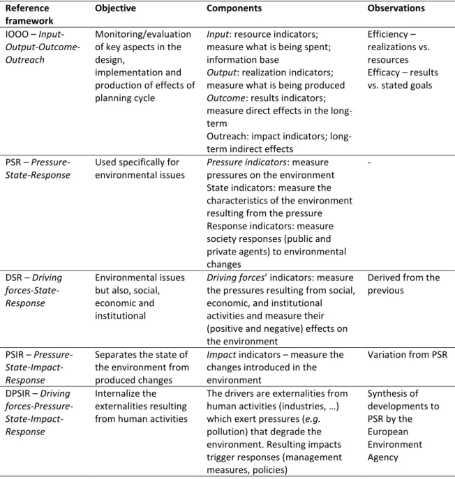
Table 2.4. Main concerns and suggestions for improving the proposed framework 59 Table 3.1.Examples of reference frameworks for indicator systems ………. 73
Table 3.2.Examples of marine spatial planning initiatives worldwide ……….. 78
Table 4.1. Objectives of Portuguese MSPlans (abridged from DL 38/2015) ………….. 89
Table 4.2.Proposed indicators for objective b) ………. 90
Table 4.3.Proposed indicators for objectives c), d), e), and f) ………. 91
Table 4.4. No. of interviews in terms of the main expertise of the interviewees ….. 93
Table 4.5. Synthesis of results ……… 94
Table 4.6. Revised indicators for objective b) …..……….. 101
Table 4.7. Revised indicators for objective c) …..……….. 102
Table 4.8. Revised indicators for objective d) …..……….. 102
Table 4.9. Revised indicators for objective e) …..……….. 103
Table 4.10. Revised indicators for objective f) …..………. 103
Table 4.11. Categories and numbers of participants …..……….. 104
Table 4.12.Answers to “How does MSP contribute to the country’s SD?” ……… 106
Table 4.13.Answers to “How should a correctly planned NMS be?” ………. 108
Table 4.14.Answers to “How do you envision national MSP to look like in 10 y?” .. 109
Table 4.15. Results of the classification of indicators proposed for objective b) ….. 112
Table 4.16. Results of the classification of indicators proposed for objective c) ….. 113
Table 4.17. Results of the classification of indicators proposed for objective d) ….. 113
Table 4.18. Results of the classification of indicators proposed for objective e) ….. 114
Table 4.19. Results of the classification of indicators proposed for objective f) ….. 114
Table 4.20.Results of the voting for the “top 10” indicators ………. 116
Table 4.21. Information relative to the 15 most voted indicators ……….. 117
Table 5.1. Elements of the indicator factsheets ……… 132
Table 5.2. EBM – Environmental status of the marine environment factsheet …….. 133
Table 5.3. EBM – Condition of Marine Protected Areas factsheet ……… 135
Table 5.4. EBM – Well-being: cultural/spiritual value of the sea factsheet ……… 136
Table 5.5.“Data and knowledge” factsheet ………. 138
Table 5.6.“MSP by area and type of activity” factsheet ………..….. 139
Table 5.7.“Transparency” factsheet ………. 140
Table 5.8.“Stakeholder participation” factsheet ..……….. 143
Table 5.9.“Ensure legal effect of MSP” factsheet …..………. 144
Table 5.10. Coordination – Promote economic exploitation factsheet ………. 146
Table 5.11. Coordination – Employment in maritime sectors factsheet ……….. 147
Table 5.12. Coordination – Conflict factsheet ………. 148
List of figures
Figure I.1. Link between the three specific objectives of this research ……….. 4
Figure 2.1.Portugal’s national maritime space ……… 37
Figure 2.2. Estimated distribution of marine mineral resources in the NMS ….………. 38
Figure 3.1. The planning cycle ……….. 66
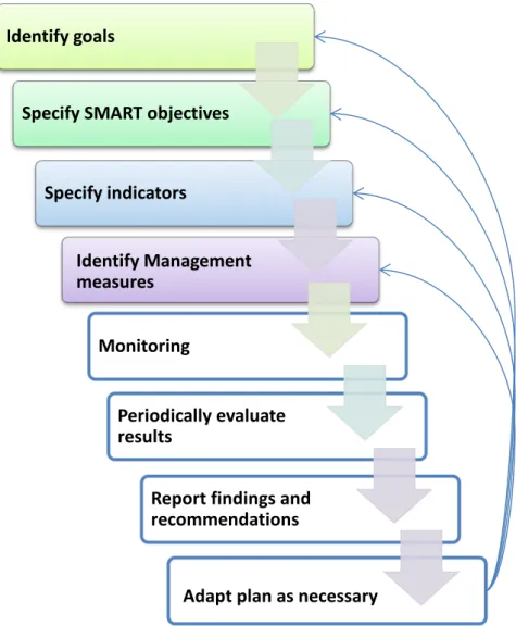
Figure 3.2. Simplified logical model of the connection between goals, objectives, indicators and management measures in MSP ……… 67
Figure 3.3. Key-steps of adaptive planning and management processes ………. 69
Figure 3.4. The Daly triangle relating natural capital to well-being …….……….. 75
Figure 3.5. Cause and effect diagram integrating the key principles of MSP .…………. 82
Figure 3.6. The policy cycle of the Portuguese MSP process …….………. 83
Figure 4.1. Indicators for objective b) …….……… 95
Figure 4.2. Example of individual indicator classification sheet ….……….. 110
Figure 4.3. Example of group indicator classification sheet ….……… 111
Figure 4.4. Results of the voting for the top 10 indicators ………..….. 115
Figure 4.5. Programme of the debate session .………. 119
Figure 4.6. Top 15 indicators divided by objectives ………..………… 119
Figure 4.7. Top 15 indicators separated in terms of potential information sources .. 120
Figure 4.8.Public conference on Portugal’s developing MSPM system ………. 124
Figure 4.9.Participatory workshop on indicators to evaluate Portugal’s MSP system performance ……… 125
Figure 4.10. Press coverage of the debate session held at FCSH/UNL in 07.06.2016. 126 Figure 5.1. Legally stated objectives matched with key principles of MSP ……… 130
Figure 5.2.Proposed evaluation mechanism to assess performance of Portuguese MSP ………. 131
List of acronyms
CBA – Cost-Benefit Analysis
CBD – Convention on Biological Diversity
CLCS – Commission on the Limits of the Continental Shelf CMSP – Coastal and Marine Spatial Planning
DGPM –Portugal’s General-Directorate for Maritime Policy EAP –EU’s Environmental Action Program
EBM – Ecosystem-based management EC – European Commission
EEA – European Environment Agency EEZ – Exclusive Economic Zone
EIA – Environmental Impact Assessment EU – European Union
EUSDS – European Union Sustainable Development Strategy
FCSH/UNL –Faculdade de Ciências Sociais e Humanas/Universidade Nova de Lisboa FCT – Foundation for Science and Technology
GDP – Gross Domestic Product GES – Good Environmental Status GIS – Geographic Information System GS – Good status
ICM – Integrated Coastal Management
ICZM – Integrated Coastal Zone Management IMP –EU’s Integrated Maritime Policy
IOOO – Input-Output-Outcome-Outreach
MPA – Marine Protected Area MRE – Marine Renewable Energy
MSFD –EU’s Marine Strategy Framework Directive MSP – Marine Spatial Planning
MSPlans – Marine Spatial Plans
MSPM – Marine Spatial Planning and Management NGO – Non-Governmental Organization
NM – Nautical mile
NMS – National Maritime Space NOP – National Ocean Policy NOS – National Ocean Strategy
POEM –Plano de Ordenamento do Espaço Marítimo R&D – Research and Development
SD – Sustainable Development
SDG –UN’s Sustainable Development Goal SEA – Strategic Environmental Assessment
SMART – Specific, Measurable, Achievable, Relevant, Time-bound TUEM –Taxa de utilização do EMN (private use feee)
U.S. – United States UK – United Kingdom UN – United Nations
UNCLOS – United Nations Convention on the Law of the Sea UNEP – United Nations Environment Programme
Foreword
1972, the year when I was born, marked some type of global awakening to the increasing environmental deterioration of our home, this “mote of dust suspended in a
sunbeam”. I grew up listening about the hole in the ozone layer, about climate change
and a poisoned environment – I remember looking out the window worrying if some or how much radiation from Chernobyl was upon us, hoping it would be just too far away.
Born and bred in Portugal, and the daughter of a sailor, the sea was a constant in my life. I knew, since the age of 8, the two things I wanted to be when I grew up: a mother, and a scientist. Further inspired by Jacques-Yves Cousteau, whose documentaries I religiously watched every Sunday morning on TV, a more specific focus on saltwater environments was soon decided upon…
Now, at 44, I am a mother (of a wonderful 12-year old girl) and a scientist of sorts (biologist, ecologist, environmental activist), primarily focused on coastal environments, and more recently, with some added grasp of geography and planning, on the marine environment. My broad goals (and some more specific objectives) charted as a child for my future self, were broadly reached. In performance evaluation, this would undoubtedly equate to success. But implementation continues…
Part of the deal of being a mother and a scientist of sorts is the responsibility to actively contribute to promote a safe operating space for humanity – one that will allow my daughter to grow up happy and healthy in a healthy planet, where her children, and all children, now, then, and after, can grow happy and healthy too. Our daily options in everything we do are nothing more than the management measures that will lead us closer or further away from that objective – and time is of the essence.
This thesis offers a humble yet hopeful contribution to inform Portuguese MSP as it progresses towards implementation – so that 30-50 years from now those who are still around may conclude that Portuguese MSP contributed to reach the broad goal of sustainable development of our marine environment on this planet Ocean.
La mer
Qu'on voit danser Le long des golfes clairs A des reflets d'argent La mer
Des reflets changeants Sous la pluie
La mer Les a bercés
Le long des golfes clairs Et d'une chanson d'amour La mer
A bercé mon cœur pour la vie
Introduction
Introduction
A need to advance performance evaluation of Marine Spatial Planning
The ocean is increasingly viewed as the last frontier (Norse, 2007). As resources dwindle on land, attentions turn to the maritime realm as a renewed source of opportunities for growth. One notable example is the European Commission’s Blue Growth strategy, listing opportunities for marine and maritime sustainable growth (EC, 2012). However, as human activities gradually encroach on the ocean, requiring more and more ocean space, the number of conflicts among activities and between humans and the marine environment is expanding, contributing to a concurrent degradation of ocean health (EEA, 2015; UN, 2016).
Recognition of this reality has led to growing scientific and political attention being given to ocean governance, and, particularly, to Marine Spatial Planning (MSP). MSP has
been defined as “a public process of analysing and allocating the spatial and temporal distribution of human activities in marine areas to achieve ecological, economic, and social
objectives that are usually specified through a political process” (Ehler & Douvere, 2009, p. 18). Being a public planning process, MSP must, i.a., be based on transparency and participation/stakeholder engagement (CEC, 2008), as ways to foster better decisions, buy-in of solutions (buy-includbuy-ing compliance with legislation), and democratic credibility (Wates, 2006). Though relatively recent as an approach, MSP is gradually being implemented worldwide (Ehler, 2014), in Australia, the U.S., African and Asian countries, and in Europe, where a number of Marine Spatial Plans already exist (e.g., UK, Belgium, The Netherlands, Germany, Norway), and a Directive establishing a framework for MSP is already in place (OJEU, 2014). Today, MSP is generally accepted as a prime tool to promote sustainable development of the marine environment (Flannery and Ellis, 2016). However, as demonstrated by recent findings on the practice of MSP (e.g., Jones et al., 2016), an evaluation of MSP initiatives and their performance is critical, “otherwise optimism that
these ideals have been achieved because an increasing proportion of the world’s seas are
Performance evaluation, an assessment of progress toward the achievement of pre-defined goals or objectives in planning, usually based on sets of indicators, albeit often neglected, is a key learning element in the planning/governance cycle (Laurian et al., 2010). It allows agencies/governments and society to objectively assess how successful implementation was, namely in terms of efficiency or of efficacy, including effects on the environment and on the social-economic-institutional/governance systems such initiatives target or affect (Ehler, 2014; Gobierno de España, 2010; Mascarenhas et al., 2012, 2015; UNEP, 2014). In the field of public initiatives for the ocean, various frameworks have been developed for the evaluation of planning or management initiatives, such as Marine Protected Areas (MPAs), or Marine Spatial Plans (e.g., Belfiore et al., 2006; Douvere, 2010; Ehler, 2014; Hockings et al., 2006; Pomeroy et al., 2004). In terms of concrete initiatives, various Marine Spatial Plans include sets of indicators for their evaluation, namely: the Great Barrier Reef Marine Park in Australia (GBRMPA, 2014); in the U.S., Rhode Island’s Special Area Management Plan (McCann et al., 2013, Mulvaney, 2013), and Massachusetts Ocean Management Plan (Commonwealth of Massachusetts, 2015); in Europe, Scotland’s
Shetland Islands Marine Spatial Plan (SIC, 2013), England’s East Inshore and Offshore Marine Plans (MMO, 2014). However, despite these examples, a “low priority [is] assigned in
practice to evaluation of marine management in general and MSP in particular” and there is still limited experience of MSP and insufficient implementation data (Carneiro, 2013, p. 215). As such, Carneiro concludes, evaluation on the MSP cycle still requires dedicated research.
Research on spatial planning, including on its evaluation component, has, first and
foremost, “an action orientation”, i.e., an “ambition that research findings will ‘make a
difference’” in relation to the social and political reasons (initiatives) that motivated the
research (Silva et al., 2015, p. xxvi). On a related note, Ferrão (2011) challenged spatial planning specialists (as mediators of dynamics and solutions) to collaborate with political agents with the objective of making public policies more efficient, specifically through promoting the evaluation of public policies from the perspective of institutional learning.
Introduction
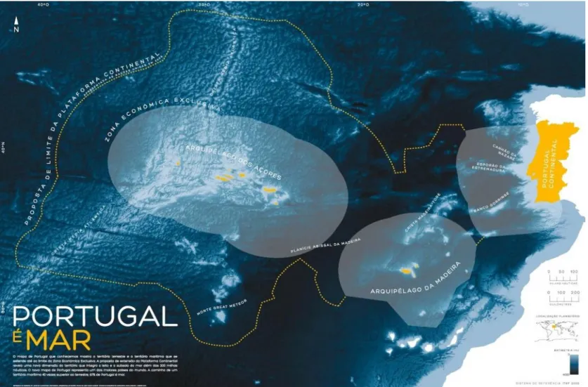
area of continental shelf beyond 200 nautical miles) makes up 97% of the nation’s territory,
and includes nearly 50% of the volume of European Union’s marine waters (MAM, 2014). The entire Portuguese National Maritime Space (NMS) corresponds to about 4% of the Atlantic and 1 % of the global ocean (Bessa Pacheco, 2013). Since 2014, a new bundle of national legislation has been put in place for the Portuguese NMS, including the National Ocean Strategy (NOS) 2013-2020 (Resolution of the Council of Ministers 12, 2014), and a base law for Marine Spatial Planning and Management of the Portuguese NMS, aimed to
contribute to Portugal’s sustainable development (Law 17, 2014). Decree-Law 38/2015, which develops Law 17/2014, determines the development of a Marine Spatial Plan for the entire NMS – the Situation Plan – and the permanent evaluation of the status of national MSP (Decree-Law 38, 2015). However, no specific metrics are as yet proposed for such an evaluation. While, in the past, little or no attention was given to the evaluation of spatial planning on land as well as on the coast (e.g., Ferreira et al., 2013), as the marine spatial planning of the Portuguese NMS is developed and implemented, considering its dimension and geostrategic importance, it is vitally important that it is coupled from the onset with the discussion on how its performance (the success of those actions) will be evaluated: has MSP achieved what it set out to achieve, how close or far is it from achieving intended goals, including how is national MSP contributing to deliver sustainable development?
Aims and objectives of this research
The overall aim of the present study is to assist the emerging Portuguese MSP system in the development of an evaluation mechanism of its performance, by scoping out, through a participatory approach, a set of national/strategic level indicators. This research seeks to reflect on the way in which the current setup for MSP has been organized in Portugal through a critical analysis of the proposed system carried out with the involvement of experts, as a contribution to inform the participatory development of an evaluation framework for Portuguese MSP. More specifically, this research sets out to:
1. Analyse the current policy seascape for Portuguese MSP;
3. Propose guidelines for an evaluation mechanism for the performance of Portuguese MSP.
Figure I.1. synthesises the link between the three specific objectives of this research.
Figure I.1. Link between the three specific objectives of this research.
The unique/novel contribution of this thesis is presenting a first approach to a mechanism to evaluate performance of MSP for the entire Portuguese national maritime space, using a participatory approach. The hypothesis of this research is that it is possible and desirable to use a participatory model to develop an evaluation mechanism of the performance of Portuguese MSP, where the stakeholders themselves are direct contributors to the definition and selection of indicators, help to validate the results, and promote its implementation. This proposes a shift from the current practice of top-down, unilateral, definition of evaluation mechanisms (including indicators) in MSP, towards a new, participatory, approach to the monitoring and evaluation stages of the MSP cycle, to improve its chances of implementation and success. This signifies broadening the scope of
“the public process” beyond the planning stage into the planning evaluation stage. In so doing, it may potentially be useful to other coastal nations in the EU and elsewhere engaged in designing and implementing MSP systems and their evaluation mechanisms.
The research presented here is also action oriented. It is funded by the Portuguese Foundation for Science and Technology (FCT), and has the institutional support of the Portuguese Directorate-General for Sea Policy (DGPM), the national agency responsible for evaluating the status of Portuguese MSP. This financial and institutional support demonstrates the timeliness, pertinence, and practical interest of this research, at a moment when Portugal is actively involved in the strategic development and spatial planning of its maritime territory. Through this rapport with the national authorities that play a role in management of the Portuguese maritime space, this research also contributes to bring R&D activities closer to the country’s planning and management/operational needs. In this framework, the participatory development of an indicator system to assess
Participatory analysis of legal
framework
Participatory indicator development
process
Introduction
performance of the national MSP system, constitutes a unique opportunity to place Portugal at the forefront of scientific research in the field of monitoring and evaluation of MSP: bringing together researchers and political agents (policy-makers), to reflect on the MSP process, and contributing to its implementation and monitoring, while building examples of good practices in this field, both nationally and internationally.
Methods
For the development of a mechanism to evaluate performance of the Portuguese marine spatial planning system, an approach was used based on a combination of secondary research (literature review) and primary research (data production).
Baseline study (secondary research)
A literature review (secondary research) allowed for the establishment of the state-of-the-art concerning the topics of interest relevant to the field of performance evaluation of MSP, including practical examples of experiences with particular marine spatial plans, and related fields of sustainability and ocean health. It also provided the necessary base information to support the establishment of a participatory methodology to derive a tentative set of indicators for the evaluation of the Portuguese MSP system.
Data production (primary research)
This data production component was structured in two stages:
i) Analysis of the Portuguese legal framework for MSP, based on the insights and
perceptions of national and international MSP experts, as a starting point to guide and frame the selection of indicators for evaluation performance of Portuguese MSP. Two studies were carried out:
o an analysis of international experience in MSP focusing on the U.S.;
o perceptions of Portuguese experts on the Portuguese legal framework for MSP;
ii) Indicator development process.
Analysis of the Portuguese legal framework for MSP
the value of existing dialogue on ocean governance between the U.S. and Europe (e.g., the CALAMAR project (2011), the Dräger Foundation’s (2013) EU-U.S. conference series, the Galway Statement (2013)), it was deemed timely to consider the U.S. experience in MSP processes. In particular, understanding how the U.S. has addressed competing uses, and evaluated alternatives, is relevant to any discussion of parallel European and Portuguese efforts, and was used to highlight potential similar challenges during the implementation of Portuguese MSP.
To have a handle on the perceptions of Portuguese experts on the Portuguese legal framework for MSP, on 16 January 2015, an expert conference was organised at FCSH/UNL to discuss the Portuguese MSP legal framework at the time: the Law establishing the Basis of the Policy for Marine Spatial Planning and Management of the National Maritime Space (NMS) (MSPM Law: Law 17, 2014), and a Decree-Law Proposal developing the implementation of the MSPM Law and transposing EU’s MSP Directive (later Decree-Law 38, 2015). The conference had a double objective: i) to discuss the Portuguese MSP legal framework, particularly the Decree-Law Proposal; ii) to produce a document to be sent to the government with suggestions for improvement. The conference was organized in three sessions (Spatial planning, Law, and Environment) with specialists in themes related to MSPM from academia and civil society as invited speakers.
The main findings of both analyses were used to feed the indicator selection process and the development of the MSP evaluation framework, and to contribute to the body of proposals for improving the national MSPM framework.
Indicator selection process
For the participatory development of indicators to evaluate performance of Portuguese MSP, a mixed-methods approach was adopted consisting of a combination of qualitative findings from expert/stakeholder interviews, substantiated by quantitative indicator rankings from questionnaires and votings.
Introduction
evaluation bibliography. Steps 3-5 consisted of the participatory part of the process. The five steps are detailed below:
Step 1 – Identify adequate objectives: identification of the most appropriate source
of objectives to assess performance of national MSP;
Step 2 – Pre-selection of indicators: identification of potentially relevant indicators in
relation to the objectives of national MSP, selected from the national and international literature on the topic of MSP evaluation;
Step 3 – Indicator screening by experts: screening of selected indicators through
one-on-one semi-structured interviews with national and international experts in the fields of MSP and evaluation to streamline a list of relevant indicators, based on qualitative and quantitative data;
Step 4 – Participative workshop: independent expert discussion exercise with
Portuguese MSP practitioners and other MSP related agents and stakeholders, including but not limited to the experts involved in the preceding step, to discuss the streamlined list of indicators and select the most relevant ones.
Step 5 – Public debate session: A public session for the presentation of the indicators
selected, focused on obtaining high-level institutional feedback from the heads of the main
agencies responsible for Portugal’s MSP, and on providing an opportunity of opening the debate to, and getting feedback from, a wider audience of stakeholders/public.
This iterative approach was designed as an adaptation of the Delphi method or Delphi technique (Hsu & Sandford, 2007; Linstone & Turoff, 2002; Thangaratinam & Redman, 2005) to fit the specificities of this research.
Structure of the thesis
The thesis consists of an introduction, five chapters, and a conclusion.
Chapter 1, “Sustainable development in the Pale Blue Dot”, frames marine spatial planning as the most widely accepted ocean governance tool for sustainable development in the marine environment. The concepts of sustainable development and of planetary boundaries on our Ocean planet, where the health of the marine ecosystem continues to degrade, are discussed to frame the discussion on sustainable development goals and of the need for strong ocean governance frameworks and tools. It also reviews the emergence and development of MSP worldwide, and more particularly in the EU, in terms of the drivers, policies and established principles and guidelines for MSP.
Introduction
aspects, which, in the experts’ understanding constituted weaknesses or threats to optimal
implementation (results published in Ferreira et al., 2015b, 2015c).
Chapter 3, “Evaluation and indicators in planning”, reviews the importance of evaluation in planning, namely performance evaluation, particularly in marine policy frameworks and marine spatial planning and related plans and justifies the need to develop further the field. It reviews definitions and ideal characteristics of indicators and of indicator selection criteria, and presents an overview of useful indicator frameworks (it uses results of secondary research published in UNEP, 2014). The chapter also includes a section on the evaluation of coastal and ocean plans and policies in Portugal.
Chapter 4, “Indicator system development process: methods and results”, presents in detail the five components of the step-by-step methodology designed for the development of an indicator system for the performance evaluation of Portuguese MSP (includes results published in Ferreira, 2016, 2016b; Ferreira et al., 2016, 2016b). It also includes the presentation and assessment of the dissemination/communication initiatives carried out during this study.
The “Conclusions” highlight the original contribution of this research to evaluate performance of Portuguese MSP, including an assessment of the achievement of general and specific objectives of this research and a summary of the strengths and weaknesses of the adopted approach. A list of specific recommendations to improve performance evaluation of Portuguese MSP is presented. Attention is drawn to the unique role of the social sciences in forwarding a better practice in MSP.
As mentioned above, parts of the research included in this thesis have already been published in peer-reviewed papers and reports, excerpts of which are used in this manuscript (a note is made at the head of the chapters whenever that is the case). As such, not all references consulted during this research are used (and listed) in this manuscript. Some will only be found in the original full texts of the papers/reports.
Sou a estrela do mar
Só a ele obedeço, só ele me conhece
Só ele sabe quem sou no princípio e no fim
Só a ele sou fiel e é ele quem me protege
Quando alguém quer à força
Ser dono de mim
(I am the sea star,
I only obey the sea, only the sea knows me
Only he knows who I am in the beginning and the end
Only to him I am faithful and it is he who protects me
When someone wants by force
To own me)
Sustainable development in the Pale Blue Dot
Chapter 1 - Sustainable development in the Pale Blue Dot
1.1. “You are here”1
In early February 1990, as Voyager 1 dashed across space to explore the universe beyond the outer limits of the solar system, it received one last command from Earth: to tilt back its camera and capture one final image of our planet. Carl Sagan explained that he
“thought it might be a good idea (…) to have them take one last glance homeward” (Sagan, 1997, p. 10). He anticipated that our planet “would be just a point of light, a lonely pixel, hardly distinguishable from the many other points of light Voyager could see (…). But precisely because of the obscurity of our world thus revealed, such picture might be worth
having” (ibid.).
The resulting image was thus described and explained by Sagan (ibid.):
… a mosaic of squares laid down on top of the planets and a background smattering
of more distant stars. (…) From this distance the planets seem only points of light (…)
Because of the reflection of sunlight off the spacecraft, the Earth seems to be sitting
in a beam of light, as if there were some special significance to this small world. But
it's just an accident of geometry and optics. (…) And why that cerulean color? The
blue comes partly from the sea, partly from the sky. (p. 11).
He finished the description by sharing his reflections on this “pale blue dot”:
… from this distant vantage point, the Earth might not seem of any particular
interest. But for us, it's different. Look again at that dot. That's here. That's home.
That's us. (…)everyone you love, everyone you know, everyone you ever heard of (…)
in the history of our species lived there—on a mote of dust suspended in a sunbeam
(…) There is perhaps no better demonstration of the folly of human conceits than this
distant image of our tiny world. To me, it underscores our responsibility to deal more
kindly with one another, and to preserve and cherish the pale blue dot, the only home
we've ever known (p. 12-13).
Sagan’s idea of taking this picture of Earth from a spot in space 6 billion km away
from our planet was to put in perspective, from 1,000 times farther away, the iconic picture taken in 1972 during the last manned mission to the Moon. From the vantage point of the astronauts on board Apollo 17, the Earth looked like a Blue Marble in the vastness of space. Sagan (1997) wrote:
While almost everyone is taught that the Earth is a sphere with all of us somehow
glued to it by gravity, the reality of our circumstance did not really begin to sink in
until the famous frame-filling Apollo photograph of the whole Earth (p. 11).
1.2. Sustainable development
In fact, that one image taken in December 1972, added visuals to the global message conveyed a few months prior, in June 1972, by the United Nations Conference on the Human Environment. The 1972 Stockholm Convention, as it became known, drew the
world’s attention to global environmental degradation and stated the first global principles of sustainable development2
.
In 1983, Gro Harlem Brundtland was called upon by the United Nations to establish and chair a World Commission on Environment and Development to charter “a global
agenda for change” with the mandate, first and foremost, “to propose long-term environmental strategies for achieving sustainable development by the year 2000 and
beyond” (WCED, 1987, p.5). In this Commission’s report, “Our Common Future” (a.k.a.
“Brundtland report”), environment was defined, simply and unequivocally, as “where we all
live”, and which “does not exist as a sphere separate from human actions, ambitions, and
needs”, and development as “what we all do in attempting to improve our lot within that
abode. The two are inseparable”. Concerning sustainability, the report stated that “Many of the development paths of the industrialized nations are clearly unsustainable. And the
2
Principle 1 of the Declaration issued therein stated that “Man has the fundamental right to freedom, equality and adequate conditions of life, in an environment of a quality that permits a life of dignity and well-being, and he bears a solemn responsibility to protect and improve the environment for present and future generations”
(UNEP, 2016). Principle 2 referred to the safeguard of the Earth’s natural resources (including especially representative samples of natural ecosystems) “for the benefit of present and future generations through
careful planning or management, as appropriate” (ibid). After the 1972 Stockholm Conference, “several states
Sustainable development in the Pale Blue Dot
development decisions of these countries, because of their great economic and political power, will have a profound effect upon the ability of all peoples to sustain human progress for generations to come” (WCED, 1987, p.7), especially to support the increasing pressure and demands of a rapidly growing human population. As such, preference for “sustainable
development” over “sustainable growth” (an expression that appeared only once in the
Brundtland report), marked a deliberate choice and the recognition, in 1987, of the existence of limits to growth on a finite planet (cf. Meadows et al., 1972). The universal adoption, at least on paper, of this new paradigm of sustainable development, took place at the Earth Summit in Rio de Janeiro, in 1992. Sustainable development has since become a major policy driver, from the global to the local level, and may be viewed as the dominant paradigm in various fields of planning and management (Gallagher et al., 2004).
The ecosystem approach
Recognition of the “alarming rate” of species extinction caused by human activities,
led the United Nations Environment Programme (UNEP), as early as 1988, to convene an expert working group to develop an international legal instrument “for the conservation of
sustainable use of biological diversity” – the Convention on Biological Diversity (CBD), opened for signature at the 1992 Rio Conference (CBD, undated). Within the context of the CBD emerged the concept of an ecosystem approach to management or ecosystem-based management (EBM) “as a paradigm to explicitly account for the interconnectedness among systems, the cumulative impacts to ecosystems and to integrate ecological, social, economic and institutional perspectives, recognising their strong dependencies” (SCBD/STAP-GEF, 2012, 11). As defined in the CBD, “the ecosystem approach is a strategy for the integrated management of land, water and living resources that promotes conservation and
sustainable use in an equitable way” recognizing that “humans, with their cultural diversity,
are an important component of many ecosystems” (SCBD, 2004, p.6). The twelve principles of the ecosystem approach stated in Decision VII/11 of CBD’s Conference of the Parties are listed in Table 1.1. (ibid.).
McLeod and Leslie (2009) recall that EBM is “grounded on the idea that ultimately
we are managing people’s influences on ecosystems, not ecosystems themselves” (p. 4),
i) Acknowledging connections, including, first and foremost, the inextricable dynamic
linkages between ecosystems and social systems, or “coupled social-ecological
systems”, meaning that “EBM is fundamentally a place-based approach” (p. 4);
ii) Cumulative impacts of multiple activities (and the individual actions therein) and how they affect the delivery of ecosystem services3 that flow from these coupled social-ecological systems;
iii) Multiple objectives, i.e., the range of benefits humans receive from ecosystems,
“rather than single ecosystem services” (ibid.).
Table 1.1. The 12 principles of the ecosystem approach (SCBD, 2004).
1. The objectives of management of land, water and living resources are a matter of societal choice. 2. Management should be decentralized to the lowest appropriate level.
3. Ecosystem managers should consider the effects (actual or potential) of their activities on adjacent and other ecosystems.
4. Recognizing potential gains from management, there is usually a need to understand and manage the ecosystem in an economic context. Any such ecosystem-management programme should:
a) Reduce those market distortions that adversely affect biological diversity; b) Align incentives to promote biodiversity conservation and sustainable use; c) Internalize costs and benefits in the given ecosystem to the extent feasible.
5. Conservation of ecosystem structure and functioning, in order to maintain ecosystem services, should be a priority target of the ecosystem approach.
6. Ecosystems must be managed within the limits of their functioning.
7. The ecosystem approach should be undertaken at the appropriate spatial and temporal scales.
8. Recognizing the varying temporal scales and lag-effects that characterize ecosystem processes, objectives for ecosystem management should be set for the long term.
9. Management must recognize that change is inevitable.
10. The ecosystem approach should seek the appropriate balance between, and integration of, conservation and use of biological diversity.
11. The ecosystem approach should consider all forms of relevant information, including scientific and indigenous and local knowledge, innovations and practices.
12. The ecosystem approach should involve all relevant sectors of society and scientific disciplines.
Planetary boundaries
Between the Rio Conference and the present, countless initiatives have been promoted worldwide, at all geographical scales, to the end of promoting sustainable development, with still insufficient results in terms of global sustainability. While, in
“Beyond the limits”, Meadows et al. (1992) concluded that the Earth’s vital ecological limits had already been exceeded and that they could even collapse by the middle of the 21st century, in 2009, Rockström and co-authors drew attention to how the Earth’s environment
3Ecosystem services may be defined as “the benefits human populations derive, directly or indirectly, from
Sustainable development in the Pale Blue Dot
has been deviating from the stable Holocene conditions that allowed the development of human civilizations, diverging from what they called a “safe operating space for humanity” 4 (Rockström et al., 2009). These authors proposed a framework based on nine planetary boundaries, three of which, in their estimation, had already been exceeded: rate of biodiversity loss, climate change, and human interference with the nitrogen cycle. In 2015, the planetary boundary framework was developed and updated, with four boundaries now believed to have been crossed: extinction rate, deforestation, atmospheric carbon dioxide (as an element of climate change), and flow of nitrogen and phosphorus (Stephen et al., 2015)5
.
Recognizing the importance and validity of the planetary boundaries framework, the European Union, through its Environment Action Programme to 2020, has set a long term
vision for 2050, of “living well, within the limits of our planet” (OJEU, 2013).
Sustainable Development Goals – Goal 14
In 2015, the United Nations put out its “2030 Agenda for Sustainable Development”,
“a plan of action for people, planet and prosperity” where the protection of the natural environment is the cross-cutting foundation for sustainable development (UN, 2015). The Agenda established seventeen sustainable development goals – one of them, goal 14 to
“Conserve and sustainably use the oceans, seas and marine resources” (UN, 2015). The paramount importance of this goal has been simply summed in Lorna Inniss and Alan
Simcock’s (Joint Coordinators of the 1st World Ocean Assessment) statement “Globally, the drive towards sustainable development cannot ignore the seven-tenths of the planet covered by the ocean. (…) We need to understand the overall benefits of the ocean to us humans, and the overall impacts of humans on the ocean” (UN, 2016)6.
Despite its vastness and the remoteness of some Ocean areas, virtually all of it is affected by some type of human pressure (Halpern et al., 2008). The First Global Integrated
4Perhaps one of the most compelling explanations of this “safe operating space for humanity” was provided
by Eugene P. Odum (1993, 1997), who used the Apollo 13 accident as a metaphor of “spaceship” Earth “and
our endangered life-support systems”. 5
Other boundaries are ozone depletion, freshwater use, atmospheric aerosol loading, chemical pollution
(renamed “introduction of novel entities” to include radioactive and nanomaterials), and ocean acidification.
6While the ocean “covers over three quarters of the Earth’s surface, contains 97% of the Earth’s water, and
Marine Assessment – World Ocean Assessment I, carried out under the auspices of the United Nations, and published in 2016, concluded (UN, 2016):
i) Climate change and related atmospheric changes seriously impact the ocean, which shows trends of increasing sea level rise and acidification, and decreased mixing and oxygenation;
ii) Global capture fisheries are “near the ocean’s productive capacity” and there is unsustainable exploitation of living marine resources in many regions, which, sometimes coupled with pollution, causes ecosystem changes, and decreased productivity of fish stocks, i.a., jeopardizing food security and biodiversity7;
iii) There are increasing pressures on marine biodiversity, not only close to densely
populated areas but also in the open ocean. Many biodiversity “hotspots” have become “magnets for human uses” increasing the potential for human pressures;
iv) Increasing amounts of pollution from land-based sources, from our growing human population, and the associated industrial and agricultural production (plastics, other harmful materials, excess nutrients) exceed local carrying capacity and have deleterious social, economic and environmental consequences;
v) Despite improvements, globally there is still and uneven distribution of the benefits provided by the Ocean, contributing to reduce the capacity of less developed countries to address the causes of ocean degradation;
vi) Increasing use of ocean space, both from the expansion of existing activities and
from the development of new ones, increase “the potential for conflicting and cumulative pressures” particularly as “in most cases, those various activities are increasing without any clear overarching management system or a thorough
evaluation of their cumulative impacts on the ocean environment” (ibid, p. 8);
vii) Sustainable ocean use cannot be achieved without coherent and overall management of the various activities affecting the ocean, based on vaster and more integrated knowledge on the ocean;
Sustainable development in the Pale Blue Dot
viii) Delays in implementing known measures to counteract the pressures identified
above means that “we are unnecessarily incurring those environmental, social and economic costs” (ibid. p. 10).
Regionally, the status of Europe’s seas is deemed to be “poor”, with “a range of human-induced pressures affecting the state of marine ecosystems directly” (EEA, 2015, p.
188). One important finding of the EEA’s 2015 “State of Europe’s Seas” report is “how the
activities using non-living marine natural capital are exerting a greater range of pressures on the living natural capital (i.e. marine ecosystem capital) than those activities using the
latter” generating “equity issues, as those dependent on healthy seas like fishing, aquaculture, tourism and biotechnology, may have their development opportunities
hindered by those who do not depend directly on a healthy ecosystem” (ibid., p. 189).
Clearly, dealing with the multiple and increasing pressures placed on the Ocean is an urgent task requiring adequate governance and management systems and thorough evaluation of cumulative impacts, grounded on solid knowledge.
1.3. Ocean governance and marine spatial planning
Until relatively recently, conflicts associated with human activities in the maritime space were perceived as being few, limiting the interest in dedicated planning and integrated management efforts. Conflicts (among users or between users and the marine environment) were solved on a case-by-case or on a sectoral basis (Cicin-Sain & Knecht, 1998; Ehler & Douvere, 2009). On the other hand, the existence of different jurisdictions over the coast and maritime space, and its sheer complexity (its fluid and dynamic nature and its complex ecology), have frustrated the integrated management of this space, and, inherently, of its planning (Cicin-Sain & Knecht, 1998; CEC, 2008).
The doctrine of the “freedom of the seas”, put forward by the Dutch Hugo Grotius in
structures that attempts to come to grips with the components and interlinkages among these various instruments have earned them the name of “horrendograms” (Boyes & Elliott, 2014). On the other hand, such a sectoral (or case-by-case) approach has typically resulted in conflict either among different human uses (user-user conflicts) or between uses and the environment (user-environment conflicts) (Ehler & Douvere, 2009). The problem, as these authors point out, is that “these conflicts weaken the ability of the ocean to provide the
necessary ecosystem services upon which humans and all other life on Earth depend” (ibid., p. 19).
Marine spatial planning evolved in this context as a way to promote “a more rational organization of the use of marine space and the interactions between its uses, to balance
demands for development with the need to protect marine ecosystems (…) (Ehler & Douvere, 2009, p. 18) (cf. Table 1.2. for definitions of MSP).
Table 1.2. Definitions of Marine Spatial Planning (MSP).
Source Definition of MSP
UNESCO-IOC’s Marine Spatial Planning Initiative webpage (UNESCO-IOC, 2015)
A public process of analysing and allocating the spatial and temporal distribution of human activities in marine areas to achieve ecological, economic, and social objectives that usually have been specified through a political process. Characteristics of MSP include ecosystem-based, area-ecosystem-based, integrated, adaptive, strategic and participatory.
Marine Spatial Planning in the Context of the Convention on Biological Diversity (SCBDSTAP—GEF, 2012, p. 6)
A framework which provides a means for improving decision-making as it relates to the use of marine resources and space. It is based on principles of the ecosystem approach (EA) and ecosystem-based management (EBM). All MSP exercises are spatial (place-based) management processes no matter at what scale and in what social context or biome it is being practiced. It is also temporal, utilizing forecasting methods and fully taking into account seasonal dimensions. Directive 2014/89/EU
establishing a framework for maritime spatial planning (EU, 2014, p. L 257/140)
A process by which the relevant Member State’s authorities analyse
and organise human activities in marine areas to achieve ecological, economic and social objectives;
Executive Order 13547 --Stewardship of the Ocean, Our Coasts, and the Great Lakes (White house, 2010, p.2)
Sustainable development in the Pale Blue Dot
At the onset, MSP was associated with the management of marine protected areas (MPAs) and nature conservation, starting in Australia’s Great Barrier Reef Marine Park, whose first spatial plan was developed in 1981, and in 1997, in the United States, with the Florida Keys National Marine Sanctuary Management Plan (Douvere, 2010; NOAA, 2011). More recently, in densely used marine areas, marine spatial managementof multiple uses (including nature conservation) has progressively been implemented (Douvere, 2010).
Though relatively recent as an approach, MSP is being increasingly endorsed and used worldwide as a tool to the integrated management of growing human demands on marine resources (Ehler, 2014; UNESCO-IOC, 2015). In fact, according to Flannery et al.
(2016), MSP “has rapidly become the most commonly endorsed management regime for
sustainable development in the marine environment” (p. 121) and is now considered one of the most pragmatic tools to implement Ecosystem-Based Management (EBM) (Douvere, 2010; SCBD/STAP-GEF, 2012)8.
MSP is ecosystem-based, integrated (horizontally, across sectors/agencies, and vertically, among levels of government), place- or area-based, adaptive, strategic and anticipatory (focusing on the long-term), and participatory (Ehler & Douvere, 2009). In fact, according to these authors, MSP is, in many ways, similar to integrated coastal management
(ICM) in that both approaches are “integrated, strategic, and participatory” and that “both aim to maximize compatibilities among human activities and reduce conflicts” (user-user; user-environment) (ibid, p. 22).
1.4. MSP in Europe
In line with the international arena, over the last decade the European Union (EU) has developed its policy framework for integrated ocean management and MSP. Among the most relevant elements are the Integrated Maritime Policy (IMP), the Roadmap for MSP, the Marine Strategy Framework Directive (MSFD), the European Strategy for the Atlantic Ocean
8 ICES (2005, p.4) has offered a definition of the Ecosystem Approach for the marine environment as ‘a comprehensive integrated management of human activities based on the best available scientific knowledge about the ecosystem and its dynamics, in order to identify and take action on influences which are critical to the health of the marine ecosystems, thereby achieving sustainable use of ecosystem goods and services and