HYDROLOGICAL RISKS CHARACTERISTIC FOR
PRAPASTIILOR DRAINAGE BASIN, PIATRA CRAIULUI
MOUNTAINS
ANCA MUNTEANU1, VALENTINA ILINCA STOICA 1
ABSTRACT. – Hydrological Risks Characteristic for Prăpăstiilor Drainage Basin, Piatra Craiului Mountains. The subject of this paper aims to present the
characteristics of extreme hydrological phenomena form Prăpăstiilor Drainage Basin. Prăpăstiilor Drainage Basin is situated in the north-eastern part of Piatra CraiuluiMountains, eastern Carpathians. The structural conformation, given by the presence of Piatra Craiului syncline and by the limestone-conglomerate lithologic pattern, determines certain characteristics of the hydrographic network, which is mostly temporary, because of the water infiltration into the substrate. The springs, which provide permanent flow to the network, occur only on the syncline axis and at the base of slope deposits. When entering the gorge areas, they disappear in the same substrate, and reappear as springs, downstream of the gorges. Thus, because of these aspects, over which climate elements overlap, during periods of heavy rain, extreme events like floods frequently occur in different sectors. Effects on the environment components are complex. The floods accelerate the erosion, can affect the forest roads, construction or isolated houses along water bodies. Sometimes, the floods reach Zărnești town, causing damages or casualties. This paper comes to complete studies conducted till present on the enigmatic Piatra Craiului Mountains and its surroundings, which were included in Piatra Craiului National Park.
Keywords: hydrological risks, hydrographic factors, floods, Prăpăstiile Zărneștiului Drainage Basin, Piatra Craiului Mountains.
1. INTRODUCTION
The subject of this paper aims to present the characteristics of
extreme hydrological phenomena in
Prăpăstiilor
Drainage Basin, which is
situated in the north-eastern part of Piatra Craiului Mountains, towards
Rucar - Bran Corridor (tributary of Barsa Mare). The presence of extreme
hydrological phenomena in this drainage basin, as in all Piatra Craiului
Mountains, drew attention to those who have studied various aspects of
natural hazards in the area (Constantinescu, 1977, 2006, 2009, Munteanu,
2009, Munteanu, Constantinescu 2006). Morphological aspects, determined
by the geological and structural substrate, which overlap the climatic
1
elements, give the characteristic of hydrographic network that meets the
ideal conditions for the manifestation of hydrological phenomena. They are
represented mainly by floods, torrential rains, but also droughts can be
registered. Due to local conditions, during periods of heavy rain, extreme
events like floods frequently occur in various sectors, especially on the main
watercourses. Their effects on the environment components are extremely
complex. Thus, they accelerate erosion, deepening and changing the
riverbeds, may affect county and forest roads located along the
watercourses, buildings or isolated houses. Sometimes, the floods reach to
Z
ă
rne
ș
ti town, causing damages or casualties (Munteanu, Constantinescu
2006).
2. METHODOLOGY
The methodology used in this paper relied, in a first phase on
documentation through the study of relevant literature regarding hydric
extreme phenomena (Barry, 2008; Marchi et al. In 2010, McClymont et al.,
2010; Sorocovschi, 2002 , 2011; Sorocovschi et al., 2008; Versini et al.,
2010; Voiculescu, 2004). Afterwards, the study itself focused on the
identification, analysis and presentation of local characteristics of areas
vulnerable to hydric phenomena as well as how the substrate and climatic
event can determine certain conditioning of occurrence. Data and materials
used for conducting this study rely mainly on observations and field
research on a range of several years, in different periods. Because there are
no weather stations or permanent climatic observation points, there is no
quantitative statistical data for this basin. Therefore, no statistical analysis of
these phenomena was possible.
Cartographic materials were also analyzed: maps (at various scales
and editions), aerial photographs, satellite images, orthophotoplans, and
photos. A number of general climate data were added to these (Teodoreanu,
1980, 2006). Maps were made by processing of Ikonos 2004 satellite images
(provided by Piatra Craiului National Park Administration), using ArcView
3.2 software. The morphological conditions of areas vulnerable to floods
were determined (Munteanu, Constantinescu, 2006). Finally, to corroborate
information provided by cartographic materials with field observations,
areas affected by these risks were identified.
3. RESULTS AND DISCUSIONS
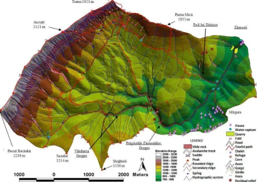
rocky, narrow, steep appearance of its gorges, locally called precipices, and also due to its large thalweg and great flow rate at flood regime. In this way, the toponym marks also the presence of this phenomenon. Its position, at the contact of Piatra Craiului Mountains with Rucăr-Bran Corridor, determines certain morpho – hydrographic particularities. The general appearance is given by the presence of limestone and conglomerate syncline, its western flank being represented by Piatra Craiului Ridge (at 2000 m altitude) and the eastern one having lower altitudes (1300-1550 m). Through the eastern flank, Prăpăstiilor Valley has cut sectors of gorges in its way to Brasov Depression. The general direction of flow is towards northeast. Altitudes between 700-2238 m, favor the occurrence of extreme hydrological phenomena (Munteanu, Constantinescu 2006, fig. 2).
Fig. 1. Location of the studied area within National Park Piatra Craiulu and Romania
(left) and traces of the floods in the Vlădușca Gorges (right)
The NE-SW orientation and the appearance of the ridge, with peaks over 2000 m (Baciului Peak 2238 m, the highest in the massive in south-west), provides an amphitheater arrangement. To the east and southeast a number of short slopes descend from the hills towards the Corridor, linking south, in “La Table” area, with “Muchia Gainii”, towards the ridge. This determines the valleys default routes, many fault generated. The river Basin gathers its network from the ridge area towards downstream area, toward the syncline axis, the valleys joining in the gorges area. The most important valleys are Vlăduşca, Mărtoiu, Brusturel,
into the substrate. The springs, which provide permanent flow to the network, occur only on the syncline axis and at the base of slope deposits. When entering the gorge areas, they disappear in the same substrate, and reappear as springs, downstream of the gorges. (Constantinescu, 2006). In the high-altitude areas, valleys routes are mainly modeled by nival processes, by avalanches (Munteanu, 2009) (Fig. 1, 2).
The role of climate characteristics is particularly important in triggering risk phenomena (Simenhois, Birkeland, 2010). Together with the existing morphology, the climate elements represent characteristics of mountain climate zone (Bogdan, 1996). Average annual rainfall gradient is 15-20 mm/100m: 40 mm/100m between 1700-1800 m altitude and 100-120 mm between 1700 and 2000 m altitude (Teodoreanu, 2006).
Fig. 2. General geomorphologic map of Prăpăstiilor Basin, marking the sectors where
the floods occur. Torrentially can be observed throughout the river network (after Munteanu, Constantinescu 2006, with modifications)
1000-1200 mm. More than half of the annual amount of precipitation falls only within 4 months (May-August), when the greatest number of days with rain is recorded. It is the season with the most intense torrential activity and greatest probability of hydrologic risk phenomena occurrence (Fig. 3 left) (Teodoreanu, 1980).
Analyzing in percents the seasonal data, it appears that most precipitations are recorded in the summer months 36.9% at Fundata and 34.4% at Omu Peak; the fewer are in winter (16.5%) at Fundata, and in autumn (16.4%) at Omu Peak; in spring, for both weather stations the record is just a little over 25% (Fig. 3 right) (Teodoreanu, 1980).
Fundata Vf. Omu
Fig. 3. Monthly average multiannual precipitations (mm) (left) and the seasonal precipitation (%) (right) (after Teodoreanu, 1980)
Floods occur during heavy rains of spring, because of the snow melting and during summer showers. The largest impact on slope erosion and riverbed dynamic processes will have the heavy rains. Throughout the year, rain showers accompanied by lightning and hail occur from April-May until November. Also the important rain showers are the ones that may cause short-term surface flow on some of the valleys descending from the ridge (Teodoreanu, 1980, Constantinescu, 2006; Munteanu, 2009).
Precipitations contribute to the acceleration of erosion, may cause mobilization of blocks located on slopes and drainage of debris, may cause the activation of unstable accumulations of rock or heterogeneous materials, may cause unexpected floods on main watercourses, especially on those with karstic flow (Fig. 2, 4) or on torrential tributary bodies. Also, because they reduce visibility, may become a potential risk factor for tourists (Constantinescu 2006, Munteanu, 2009).
Valley). In this valley, floods may occur, even if rainfalls occur only upstream, not in the gorges, as it happened in the summer of 2002 or 2004.
Padina lui Dănişor tributary, a torrent along one of the most traveled trails that reach Curmătura Chalet, was affected by torrentiality on June 28, 2008 and July 12, 2009. Flood destroyed part of the county road and damaged the cars of tourists, parked right in the direction of the alluvial cone (Fig. 2, 5).
Fig. 4. Aspects from gorge sectors. Prapastiilor Valley in the area of springs, which dried up in 201 1(left) . Facilities made to protect the county road in 2011 ( right)
Fig. 5 Flood risk areas in the Prăpăstiilor Drainage Basin
forest roads are also used for access to the chalets (especially Curmătura Chalet) or for the access of tourists to the gorges or to the central and southern part of the massif. The downstream part of the road along the valley, from Zărneşti to Podul
Măgurii, is a county road. Therefore, there have been created a number of facilities, with protective walls, strengthening of embankments (some were made with material from the quarry located in the area downstream which may cause other slope processes, even avalanches). In same location, in 2011 has been made a series of retention dams, in order to reduce the effects of extreme events (Fig. 4). The floods on the rivers coming from Prăpăstiilor Basin, can cause flooding of
Zărnești town.
Despite the fact that this basin is located in a mountain massif, drought may occur. Due to lack of precipitation over a longer period, surface water dries up. The phenomenon is accentuated by the presence of limestone conglomerate substrate, which allows water infiltration. It is the case of second half of 2011, when a series of springs have dried up, even those downstream the gorges, affecting the vegetation and fauna, and also touristic activities (those of Curmătura Chalet; dehydration cases increased), Zărnești town water resources (which are captured downstream of springs) were reduced (Fig. 2, 4, 5).
Due to its unique natural resources that can be found here, Prăpăstiilor Basin was included in Piatra Craiului National Park, increasing protection requirements. A more detailed knowledge of all local aspects is need, as a support of analysis of the relationships between all the components of the environment.
4. CONCLUSIONS
Extreme hydrologic phenomena, characteristic for Prăpăstiilor Drainage Basin, have a high degree of risk. This is due to local conditions, the presence of limestone and conglomerate substrate, arranged as a syncline. Hydrographic network is mostly temporary, hydrologic activities occurring as floods, along the main valleys, or on various torrential bodies, accelerating the torrential erosion. Although infrastructure is represented only by county roads, forest roads or trails, they are frequently affected, thus increasing the risk for tourists and adjacent localities. Due to extreme events, which periodically occur, a series of preventive measures were taken, through various consolidation works.
All this analysis represents a database of knowledge of natural resources, water being an essential element in the existence of this area. This material comes thus to enhance studies conducted so far on extreme risk phenomena that affect the enigmatic area of Piatra Craiului Mountains.
ACKNOWLEDGEMENTS
Administration of the Piatra Craiului National Park, the Rescue Service, the chalets keepers and the members of the Liliecii Brasov NGO.
REFERENCES
1. R. Barry (2008), Mountain weather and climate, Cambridge University Press, 506 p. 2. Bogdan O. (1996), Riscurile climatice din România, Academia Romana, Institutul de
Geogrfie, Bucureşti, p. 68-72.
3. Constantinescu T. (1977), Evolution du reseau hydrographique de la zone karstique
„Prăpăstiile Zărneştilor” (Massif de Piatra Craiului-Carpates Meridionales), Trav. Inst.
Speol „Emile Racovitza”, 16, Bucarest, p. 217-228.
4. Constantinescu, T. (2006), Torentiality and avalanches, the main present day geomorphological processes in Piatra Craiului Ridge, Reserch in Piatra Craiului National Park, 2, Ed. Universităţii Transilvania, Braşov, p. 38-46.
5. Constantinescu, T. (2009), Piatra Craiului – Studiu geomorfologic, Ed. Universitara Bucuresti, 163 p.
6. Marchi L., Cavalli M., D’AgostinoV. (2010), Hydrogeomorphic processes and torrent control works on a large alluvial fan in the eastern Italian Alps, Nat. Hazards Earth Syst. Sci., 10, p. 547–558.
7. McClymont F., Hayashi M., Bentley L. R., Muir D., Ernst E. (2010), Groundwater flow and storage within an alpine meadow-talus complex Hydrol. Earth Syst. Sci., 14, p. 859– 872.
8. Munteanu, A. (2009), Mofodinamica actuala, riscuri si hazarde naturale în Masivul
Piatra Craiului, Teză de doctorat, Universitatea Bucuresti, 282 p.
9. Munteanu A., Constantinescu T. (2006), Geomorphological aspects in Prăpăstiilor
Valley Hydrological Bassin (Piatra Craiului National Park), Research in Piatra Craiului
National Park 2, Ed. Universităţii Transilvania, Braşov, p. 44-66
10. Versini P.A., Gaume E., Andrieu H. (2010), Application of a distributed hydrological model to the design of a road inundation warning system for flash flood prone areas, Nat. Hazards Earth Syst. Sci., 10, p. 805–817.
11. Simenhois R., Birkeland K. (2010), Meteorological and Environmental Observations
from Three Glide Avalanche Cycles and the Resulting Hazard Management Technique,
Proceedings of the 2010 International Snow Science Workshop, Squaw Valley, California, 6 p.
12. Sorocovschi V. (2002), Riscueile hidrice, Riscuri şi catastrofe, I, Ed. Casa Cărţii de
Ştiinţă, Cluj Napoca, p. 55-65.
13. Sorocovschi V., Șerban Gh., Bătinaș R., (2004), Riscuri hidrice în bazinul inferior al
râului Arieș, Riscuri şi catastrofe, I, II, III,Ed. Casa Cărţii de Ştiinţă, Cluj Napoca, p.
143-148.
14. Sorocovschi V. (2011), The classification of hydrological hazard. A Point of view,
Riscuri şi catastrofe, 10, 9,Ed. Casa Cărţii de Ştiinţă, Cluj Napoca, p. 33-44.
15. Teodoreanu E. (1980), Culoarul Rucăr – Bran, Studiu climatic şi topoclimatic, Ed.
Academiei Române, Bucureşti, 165 p.